
BlockBefore
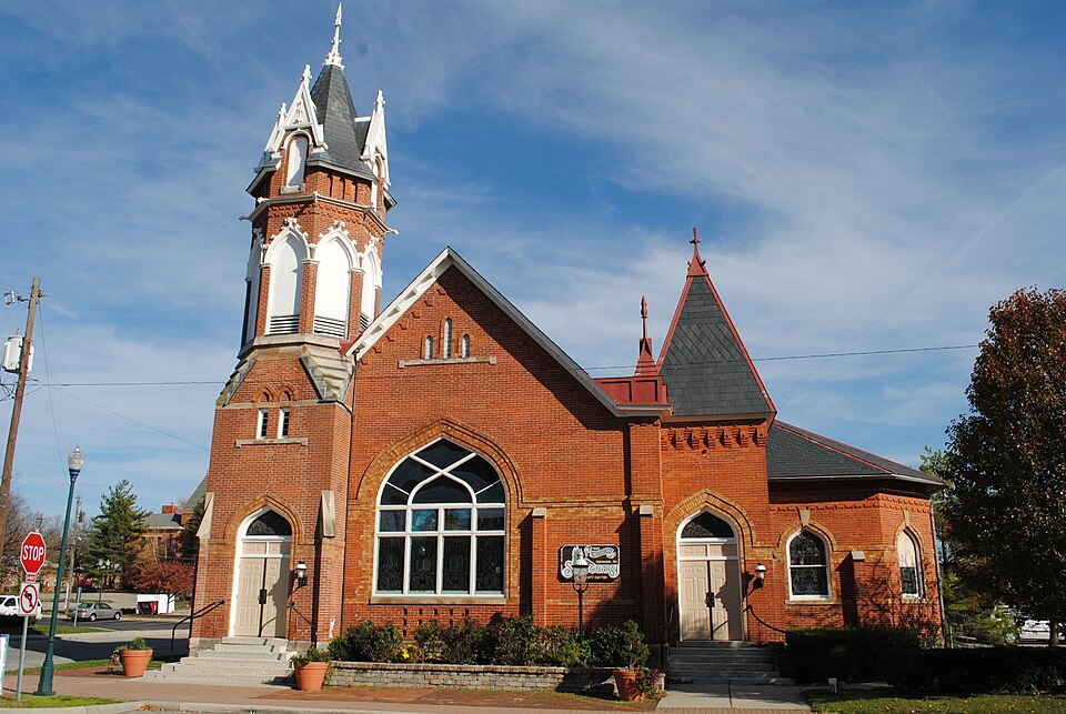
Photograph of Old Peace Lutheran Church
Photograph by Wdzinc, CC BY-SA 3.0. Via Wikimedia Commons.

Old Peace Lutheran Church

Listed on the National Register of Historic Places in 1987. A historic map-sheet match is not published yet. The record needs a coordinate-quality review before it can be joined to a sheet boundary.

From the record

one of 295 National Register listings in Franklin County · listed in 1987 · category: Building · one of 3 National Historic Landmarks in Franklin County.

Sources: the case file at the National Archives · the National Register database, National Park Service

The listing

  • What is counted as historic. The nomination lists 1 building as contributing to the listing.
  • Address. 78--82 N. High St., Gahanna, 43830
  • When was it listed? 1987-04-23
  • Category. building
  • National Register reference number. 87000640 - the number the National Park Service assigned this property when it was listed, and the key its nomination file is catalogued under at the National Archives.

Storms near this property

36 since 1994

Regional context, not property-specific evidence. The National Weather Service names Gahanna, the town this property stands in, in 36 storm reports between 1994 and 2025: 20 thunderstorm wind, 9 hail, 4 flood, 2 flash flood. No death or injury is recorded in these reports. Each account below is quoted exactly as the forecast office filed it, from the NOAA Storm Events Database, and each date opens the federal record of that event.

WhenEvent Place namedHarm What the report says
October 2006HailGahanna$100,000,000Hail up to hen egg size fell for up to 15 minutes across the eastern Columbus suburbs, causing extensive widespread damage to vehicles, homes and other structures. The hail accumulated up to several inches deep in spots, and remained on the ground well after the thunderstorm had passed.
October 2006HailGahanna$100,000Golf ball size hail fell for five to ten minutes across eastern Franklin county and covered the ground. Several homes and structures sustained damage from the hail.
June 2016Thunderstorm WindGahanna$50,000Multiple large branches were knocked down along Cherry Bottom Road.
July 2023Thunderstorm WindGahanna$5,000Several large trees were downed.
July 2012Thunderstorm WindGahanna$5,000Multiple trees six inches in diameter were reported down near Gahanna due to damaging thunderstorm winds.
June 2006Thunderstorm WindGahanna$5,000Several trees and large limbs were knocked down.
May 2000Thunderstorm WindGahanna$5,000Numerous trees downed. Nickel size hail also occurred.
July 1999Thunderstorm WindGahanna$5,000Trees and power lines knocked down.
September 1994Thunderstorm WindGahanna$5,000Trees were downed.
June 2006Thunderstorm WindGahanna$3,000Large tree limbs were downed.
August 2017Thunderstorm WindGahanna$2,000Power lines were knocked down and trees were snapped on Hamilton Road.
August 2017Thunderstorm WindGahanna$2,000Several large trees were knocked down between Gahanna Lincoln High School and John Glenn Columbus International Airport.
June 2000Thunderstorm WindGahanna$2,000Two large trees were downed...one blocking Morse Road.
June 2000Thunderstorm WindGahanna$2,000Two large trees were downed, one falling across Morse Road.
May 2015Thunderstorm WindGahanna$1,000A tree was downed.
December 2013Flash FloodGahanna$1,000A few roads were closed in Gahanna due to high water caused by heavy rainfall. One of these roads included Ridenour Road.
September 2012Thunderstorm WindGahanna$1,000A tree was downed on Crown Hill Court due to damaging thunderstorm winds.
September 2012Thunderstorm WindGahanna$1,000A tree was downed near the intersection of High and Walnut Streets due to damaging thunderstorm winds.
April 2011Thunderstorm WindGahanna$1,000Several large tree branches were broken due to the winds.
June 2025Thunderstorm WindGahanna$250Several large limbs were downed along Tresham Road.
May 2020Thunderstorm WindGahanna$250A few very large branches were snapped off of two healthy trees on Majoram Drive.
June 2019FloodGahanna-High water was reported on Hamilton Road.
July 2018FloodGahanna-Widespread street flooding was reported in Gahanna.
July 2017Flash FloodGahanna-High water was covering several neighborhood roads.
July 2017FloodGahanna-High water was reported on Bridgestone Drive.
July 2015FloodGahanna-High water was covering residential streets. Water depth was at least halfway up car tires.
July 2011Heavy RainGahanna-Standing water was reaching half way up cars due to heavy rain.
April 2024HailGahanna-no account filed
February 2024HailGahanna-no account filed
July 2012HailGahanna-no account filed
September 2012HailGahanna-no account filed
June 2012Thunderstorm WindGahanna-no account filed
April 2011Thunderstorm WindGahanna-no account filed
April 2010HailGahanna-no account filed
July 2006HailGahanna-no account filed

Every storm recorded in Franklin County

Map coverage status

No historic map-sheet match is published for this property yet. That does not mean no map exists. This record needs a coordinate-quality review before it can be joined to a sheet boundary. Browse the county's mapped places while that work is pending.

From the nomination file

1,924 words on record

When this property was proposed for the National Register, someone wrote the case for it: what the building is, and why it matters. That document is a federal record in the public domain. It is quoted below word for word, never summarised. The text was read off the scanned case file by machine, so the occasional stray character is the recogniser's and the 1970s typewriter's.

Statement of significance

Applicable National Register Criteria Areas of Significance (enter categories from instructions) Period of Significance Significant Person Church: Unknown Addition: Clotts, Ralph The Old Gahanna Sanctuary, formerly the Peace Lutheran Church, is being to its architectural significance. The building is an excellent example of building is a well preserved example of religious architecture in Gahanna. dormers, and conical roof with finial. X See continuation sheet 1895 Architecture Architect/Builder used the church on alternate Sundays. Each congregation had its own minister State significance of property, and justify criteria, criteria considerations, and areas and periods of significance noted above. and vestry. Significant Dates prevalent in allied nations during the hostilities.

The Peace Lutheran congregation was formally organized by German settlers in in 1838 and located on Johnstown Road.In the following years, as settlers the church was divided into separate German and English congregations which The congregation continued to grow after 1918,as evidenced by the for a new building at the northeast corner of Hamilton and Clark Roads.In it was identified by its German name,"Freidens."The first church was built Cultural Affiliation roughly $10,oo0.Church records do not include information on the architect L locally corner tower with ornate pointed arched arcading, steeply pitched roof assimilated into early American society, services became bilingual.

In 1867 language for worship services, a reflection of anti-German sentiment which was construction of a Parish Hall addition in 1938 designed by Ralph Clotts, a local architect and member of the Church.

Read the complete 1,924-word case file.

The whole case file for this property - 1,924 words, 17 pages, reproduced complete.

Quoted from the National Register nomination for reference 87000640, 17 pages, held by the National Archives in Record Group 79. See the catalogue record.

Listed places nearby

1 within 8 miles

Other National Register properties close enough to walk or drive between, ordered by distance from this one. Both positions come from the same geocoding pass that matched these properties to their map sheets.

Photograph PropertyDistance Listed
High and Gay Streets Historic District6.0 miles2014

Sources for this property

National Archives recordThe nomination case file for reference 87000640 in Record Group 79.
Franklin CountyAll 295 listed properties in this county.

Provenance

  • Listing record. National Park Service National Register of Historic Places, listed-properties dataset, current to 2026-05-22.
  • Map join. Address geocoded through the United States Census geocoder, then tested against the published boundary of every sheet in the USGS Historical Topographic Map Collection.
  • How this page is made. Listing fields come from federal records; map-sheet coverage is a labelled coordinate-to-boundary calculation, not a source-field claim.
  • Storms. NOAA National Centers for Environmental Information, Storm Events Database https://www.ncei.noaa.gov/stormevents/ A work of the United States government, no copyright under 17 U.S.C. 105. Narratives are quoted verbatim from the National Weather Service report and are not edited or summarised.