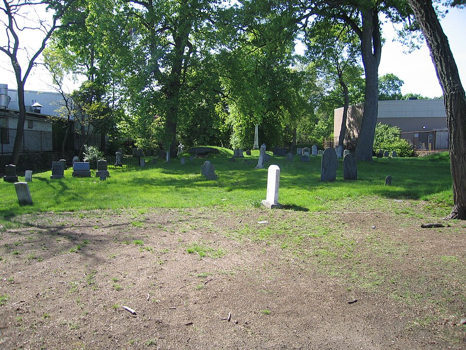
Built in 1683. Listed on the National Register of Historic Places in
1987. A historic map-sheet match is not published yet. The record needs a coordinate-quality review before it can be joined to a sheet boundary.
From the record
“The Westerly Burial Ground is an historic cemetery on Centre Street in the West Roxbury neighborhood of Boston, Massachusetts.”
Wikipedia article Westerly Burial Ground, CC BY-SA 4.0.
one of 206 National Register listings in Suffolk County · listed in 1987 · category: Site · built in 1683 · one of 5 National Historic Landmarks in Suffolk County.
National Register reference number.87001401- the number the National Park Service assigned this property when it was listed, and the key its nomination file is catalogued under at the National Archives.
What happened here
An account from the chapter on Boston city, The inset identifies its exact
source book and publication year.
IN giving some notices of manners and social life during this period, I shall speak first of usages which were characteristic of the close of the last century: most of them continued without essential modification until our city charter swept away the old landmarks, and Boston felt the im¬ pulses which mark a new epoch in her history.
It is most convenient to add here the brief details of the later annexa¬ tions. The movement in favor of adding Dorchester to the city began very soon after the union of Boston and Roxbury. It met with stren¬ uous opposition, however, in the old town. An act was passed by the Legislature of 1869, and approved June 4 of that year, submitting the question to a vote of the people in the city and town. The election was held June 22. Boston voted more than six to one in favor of annexation, the numbers being three thousand four hundred and twenty ayes to five hundred and sixty-five noes. Dorchester agreed by a small majority, - nine hundred and twenty-eight votes being cast in favor of the union, and seven hundred and twenty-six against it.2 Four years later, in 1873, the pro¬ ject of annexing several municipalities in the neighborhood was taken up in earnest. In Charlestown, in fact, the idea was an old one, having been brought forward at various times in the previous twenty years ; and for some years before 1873 the annexation question had been the leading issue before the voters of that city. As a result of the agitation the Legislature sub¬ mitted the question of annexation to the voters of Charlestown, Brighton, Brookline, and West Roxbury, the consent of the people of each place, and of Boston, being required for each separate annexation. The voting took place October 7. Boston agreed to accept all the new responsibilities offered to it, and only Brookline refused its consent to be absorbed.3 No annexations have taken place since 1873.
From March 31, 1834, to 1842, the trustees and school committee had a united supervision of the Eliot school. More recently a proposition was made to place the girls in one building under the supervision of the trustees, and the boys in another under that of the town. This proposition was accepted. Previous to this time the income of the Eliot fund had been applied to the education of children in the common English studies. The sale of some lands having increased the income considerably, the Eliot school became a high school in connection with the Roxbury city schools. After the annexation of West Roxbury to Boston, the trustees dissolved their connection with the city, and re-opened the school on Eliot Street, where it was formerly taught. It is still substantially a high school, with an elementary department, free for both sexes, and under the control of the trustees exclusively. The head-master is D. S. Smalley.
Regional context, not property-specific
evidence. The
federal wildfire occurrence database
lists 50 fires within 5 miles of Westerly Burial Ground between
2003 and 2020, burning about 358 acres in total. None started naturally. None was recorded as arson.
Distance is straight-line from the map coordinates, so a fire counted
here may appear on a neighbouring settlement's page as well.
Reported cause
Fires
Missing data/not specified/undetermined
24
Recreation and ceremony
14
Smoking
9
Equipment and vehicle use
3
The most recent of
them, most recent first, with the day each was reported and the service
that recorded it.
Regional context, not property-specific
evidence. Museums hold 12,860 specimens
collected within 10 miles of Westerly Burial Ground between 1810 and
1975: 4,918 Plantae, 4,069 Fungi, 3,222 Animalia, 293 Chromista, 202 Protozoa, 93 Bacteria, 63 Unrecorded. 12 distinct Species records are shown.
Collected by (MARSDEN, H W), ?, A B Seymour and others. Each is a
physical object with a catalogue
number, and each entry opens the museum's record. This is what was
collected and kept, not a survey of what lives here - nothing can be
concluded from a species being absent.
Regional context, not property-specific
evidence. The federal mineral resources record lists
1 working within 5 miles of Westerly Burial Ground: 1 unknown.
None of them still produces. What was taken out: Stone, Crushed/Broken. Distance is straight-line from the
map coordinates, so a quarry counted here may appear on a neighbouring
settlement's page as well.
Regional context, not property-specific
evidence. The National Weather Service names
West Roxbury, the town this property stands in, in 7 storm reports between 1997 and 2024: 3 thunderstorm wind, 2 flash flood, 1 hail, 1 flood.
No death or injury is recorded in these reports. Each account below is quoted exactly as the forecast office
filed it, from the NOAA Storm Events Database, and each date
opens the federal record of that event.
No historic map-sheet match is published
for this property yet. That does not mean no map exists. This record needs
a coordinate-quality review before it can be joined to a sheet boundary.
Browse the county's mapped places while that work is
pending.
From the nomination file
9,087 words on record
When this property was proposed for the
National Register, someone wrote the case for it: what the building is,
and why it matters. That document is a federal record in the public domain.
It is quoted below word for word, never summarised. The text was read off the scanned case file by machine, so the
occasional stray character is the recogniser's and the 1970s
typewriter's.
Statement of significance
surtal aroune West Roxbury Certifying official has considered the significance of this property in relation to other properties Massachusetts nationally statewide Lx/locally Applicable National Register Criteria xA Criteria Considerations (Exceptions) Areas of Significance (enter categories from instructions) Religion Art (funerary) community planning and development Period of Significance 1683-1900 Significant Dates N/A Cultural Affiliation N/A Significant Person N/A Architect/Builder N/A State significance of property, and justify criteria, criteria considerations, and areas and periods of significance noted above. Wester ly Burial Ground possesses integrity of location, design, materials and workmanship. The burial ground was established by a vote of the town fathers in 1683.
It is one of the few surviving elements of the 17th century settlement patterns associated with the ear ly settlement of West Roxbury, and is. its most visible reminder of the 17th century beginning of the community. It marks the focus of the earliest settlement, which included the cemetery and an adjacent church. Westerly is one of seven 17th century burial grounds in Boston,andis noted for its comprehensive collection of three centuries of funerary sculpture. The burial ground contains approximately 265 grave markers. The earliest graves are those of the town's first and most prominent families including the Drapers and the Lyons. Westerly also contains the graves of eight veterans of the Revolutionary War and fifteen Civil War Veterans.
Ground thus meets criteria A and C and Exception Dof the National Register of Historic Places on the Tocal level. Westerly Burial Ground provides a visual record of 3 centuries of the development of Roxbury and West Roxbury. It provides a history of early settlers, prominent families and the separation of West Roxbury from Roxbury in the mid 19th century. Westerly served as West Roxbury's only cemetery for 268 years. Burials at Westerly ceased in 1951.
Quoted from the National Register nomination
for reference 87001401, 36 pages, held by the National Archives in Record
Group 79. See the
catalogue record.
Listed places nearby
6 within 8 miles
Other National Register properties close
enough to walk or drive between, ordered by distance from this one. Both
positions come from the same geocoding pass that matched these properties
to their map sheets.
Listing record. National Park Service National Register of Historic Places, listed-properties dataset, current to 2026-05-22.
Map join. Address geocoded through the United States Census geocoder, then tested against the published boundary of every sheet in the USGS Historical Topographic Map Collection.
How this page is made. Listing fields come from federal records; map-sheet coverage is a labelled coordinate-to-boundary calculation, not a source-field claim.
Wildfire. Short, Karen C. 2022. Spatial wildfire occurrence data for the United States, 1992-2020 [FPA_FOD_20221014]. 6th Edition. Fort Collins, CO: Forest Service Research Data Archive. https://doi.org/10.2737/RDS-2013-0009.6 Collected with United States Government funding and usable without additional permissions or fees.
Specimens. Global Biodiversity Information Facility (GBIF), https://www.gbif.org/. Only records licensed CC0 or CC BY are used. Records licensed CC BY-NC are excluded because this site carries advertising. Images are checked individually and any whose licence is non-commercial, no-derivatives or unreadable is refused.
Mines and quarries. USGS Mineral Resources Data System (MRDS) https://mrdata.usgs.gov/mrds/ A work of the United States government, no copyright under 17 U.S.C. 105.
Storms. NOAA National Centers for Environmental Information, Storm Events Database https://www.ncei.noaa.gov/stormevents/ A work of the United States government, no copyright under 17 U.S.C. 105. Narratives are quoted verbatim from the National Weather Service report and are not edited or summarised.
 Block
Block