
BlockBefore
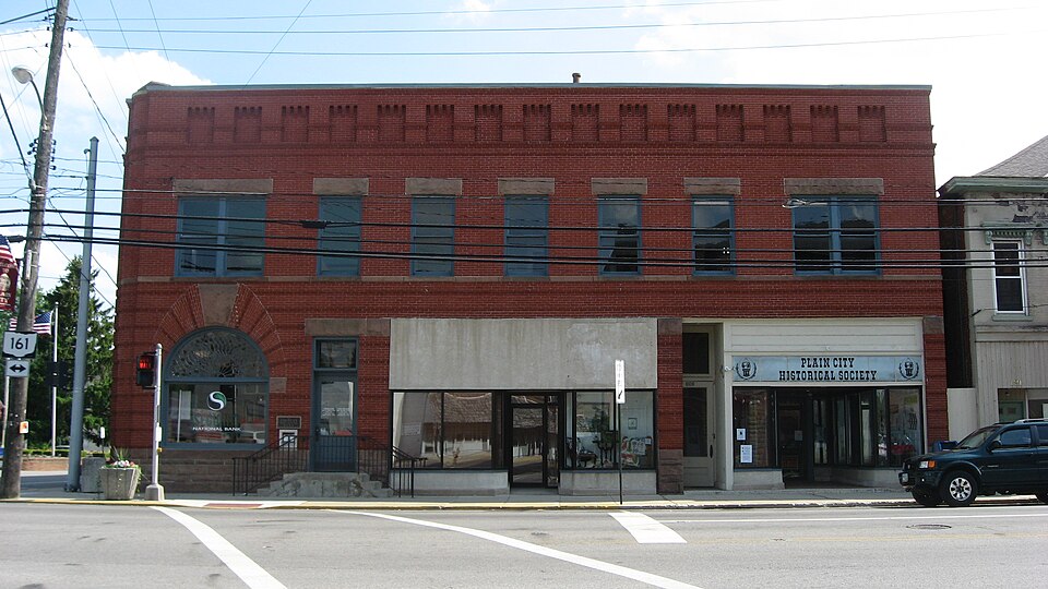
Photograph of Farmers National Bank
Photograph by Nyttend, Public domain. Via Wikimedia Commons.

Farmers National Bank

Built in 1900. Listed on the National Register of Historic Places in 1995. A historic map-sheet match is not published yet. The record needs a coordinate-quality review before it can be joined to a sheet boundary.

From the record

“Farmers National Bank is a bank building in the village of Plain City in Madison County, Ohio, United States. The bank is located at the intersection of State Route 161 and Chillicothe Street.”

Wikipedia article Farmers National Bank (Plain City, Ohio), CC BY-SA 4.0.

one of 7 National Register listings in Madison County · listed in 1995 · category: Building · built in 1900.

Sources: the Wikipedia article · the case file at the National Archives · the National Register database, National Park Service · the Wikipedia article

The listing

  • What is counted as historic. The nomination lists 1 building as contributing to the listing.
  • Address. Jct. of Main and Chillicothe Sts., SW corner, Plain City, 43064
  • When was it listed? 1995-03-09
  • Category. building
  • Township. Darby township
  • When was it built? 1900
  • National Register reference number. 95000168 - the number the National Park Service assigned this property when it was listed, and the key its nomination file is catalogued under at the National Archives.

The ground it stands on

15,559 words

The chapter on Darby Township in History of Madison County, Ohio : Its People, Industries and Institution with Biographical Sketches of Representative Citizens and Genealogical Records of Many of the Old Families, published 1915 names Plain City. This is what it says, exactly as the scans read.

In 1796, as mentioned above, Benjamin Springer, with his wife and two sons, Silas and Thomas, also his son-in-law, Usual Osborn, and wife, settled on Big Darby creek. They were natives of Pennsylvania, and built their cabin on land later owned by John Taylor, close to the north line of Canaan township and just within the limits of the same. But their names are mentioned here because of their close proximity and close relations with the early pioneers of Darby township. In 179S, the Ewing brothers, James and Joshua, emigrated from Kentucky to present Darby township and settled a short distance northeast of the site of Plain City. They bought farms lying on both sides of Big Darby creek. One reason for making their purchases on both sides of the stream was that they might have ready access to the prairie grazing lands, and at the same time have tillable lands on the elevated bottoms along the creek. They supposed, as did many others, that the open prairie land would afford them pasturage for many years to come. In this, however, they were mistaken, for they were in time owned by industrious farmers and inclosed with good fences.

Passage source: History of Madison County, Ohio : Its People, Industries and Institution with Biographical Sketches of Representative Citizens and Genealogical Records of Many of the Old Families, published 1915.

The Taylor brothers. John. Daniel and Richard, natives of New York state, emigrated to Kentucky in 1795 and settled on land they purchased near Lexington. They became discouraged and disgusted because of the constant litigations over titles, and determined to seek new lands. John Taylor, going to the man from whom he had made his purchase, made a trade with him for lands in the then territory of Ohio. By this exchange he became the owner of Ihree hundred acres of land on the banks of Big Derby, now in Union county. He moved to bis new farm in 1800, sold bis first purchase to Frederick Sager, and bought another about one mile south of Plain City, on both sides of Big Darby creek, from John Graham. Here be erected a log cabin, stable and outbuildings, and soon afterward, probably about the year 1804, be married a widow McCullough, sister of Judge Mitchell. Two children blessed this union, a daughter and a son. The daughter died in infancy, but the son, John Taylor, Jr., lived on the old homestead for many years, and is still remembered by the older residents of Darby township.

Passage source: History of Madison County, Ohio : Its People, Industries and Institution with Biographical Sketches of Representative Citizens and Genealogical Records of Many of the Old Families, published 1915.

Machine-read from a century-old scan, so expect the errors a machine makes: misspelled names, dropped words, stray characters.

Read the whole chapter on Darby Township - 15,559 words on its settlement, mills, schools and churches.

Mines and quarries near this property

2 within 5 miles

Regional context, not property-specific evidence. The federal mineral resources record lists 2 workings within 5 miles of Farmers National Bank: 2 past producers. None of them still produces. What was taken out: Limestone, General, Stone, Crushed/Broken. Distance is straight-line from the map coordinates, so a quarry counted here may appear on a neighbouring settlement's page as well.

Where SiteCommodity StatusRecorded
Darby Number 220 Limestone QuarryLimestone, GeneralPast ProducerSedimentary
Darby Number 220 Limestone QuarryStone, Crushed/BrokenPast Producer

Every working recorded in Madison County

Storms near this property

12 since 1994

Regional context, not property-specific evidence. The National Weather Service names Plain City, the town this property stands in, in 12 storm reports between 1994 and 2010: 9 thunderstorm wind, 3 hail. The reports record 1 injury. Each account below is quoted exactly as the forecast office filed it, from the NOAA Storm Events Database, and each date opens the federal record of that event.

WhenEvent Place namedHarm What the report says
June 1994Thunderstorm WindPlain City1 hurt, $5,000Trees were downed. A 17-year-old was indoors and was injured when a plate glass window shattered during the strong winds. He was treated for lacerations.
July 1997Thunderstorm WindPlain City$15,000Roof blown off a barn. Several trees and power lines downed.
July 1998Thunderstorm WindPlain City$10,000Numerous trees downed.
July 2003Thunderstorm WindPlain City$5,000Several trees were knocked down.
May 2004Thunderstorm WindPlain City$3,000Trees were downed.
July 1999Thunderstorm WindPlain City$3,000Several large limbs down.
August 2003Thunderstorm WindPlain City$2,000Two trees were knocked down.
June 2010Thunderstorm WindPlain City$1,000Large tree limbs were reported down in the area.
May 2006HailPlain City-no account filed
May 2002HailPlain City-no account filed
May 2002Thunderstorm WindPlain City-no account filed
June 1994HailPlain City-no account filed

Every storm recorded in Madison County

Map coverage status

No historic map-sheet match is published for this property yet. That does not mean no map exists. This record needs a coordinate-quality review before it can be joined to a sheet boundary. Browse the county's mapped places while that work is pending.

From the nomination file

2,773 words on record

When this property was proposed for the National Register, someone wrote the case for it: what the building is, and why it matters. That document is a federal record in the public domain. It is quoted below word for word, never summarised. The text was read off the scanned case file by machine, so the occasional stray character is the recogniser's and the 1970s typewriter's.

Statement of significance

[X C Property embodies the distinctive characteristics of a type, period, or method of construction or represents the work of a master, or possesses high artistic values, or represents a significant and - D Property has yielded, or is likely to yield, 1902 - Building erected 1930s - Security modifications - B removed from its original location. - C a birthplace or grave. - D a cemetery. -E a reconstructed building, object, or structure. - F a commemorative property. within the past 50 years.

The whole case file for this property - 2,773 words, 30 pages, reproduced complete.

Quoted from the National Register nomination for reference 95000168, 30 pages, held by the National Archives in Record Group 79. See the catalogue record.

Sources for this property

National Archives recordThe nomination case file for reference 95000168 in Record Group 79.
Wikipedia articleCommunity-written account of this property, licensed CC BY-SA.
Madison CountyAll 7 listed properties in this county.

Provenance

  • Listing record. National Park Service National Register of Historic Places, listed-properties dataset, current to 2026-05-22.
  • Map join. Address geocoded through the United States Census geocoder, then tested against the published boundary of every sheet in the USGS Historical Topographic Map Collection.
  • How this page is made. Listing fields come from federal records; map-sheet coverage is a labelled coordinate-to-boundary calculation, not a source-field claim.
  • Mines and quarries. USGS Mineral Resources Data System (MRDS) https://mrdata.usgs.gov/mrds/ A work of the United States government, no copyright under 17 U.S.C. 105.
  • Storms. NOAA National Centers for Environmental Information, Storm Events Database https://www.ncei.noaa.gov/stormevents/ A work of the United States government, no copyright under 17 U.S.C. 105. Narratives are quoted verbatim from the National Weather Service report and are not edited or summarised.