BlockBefore
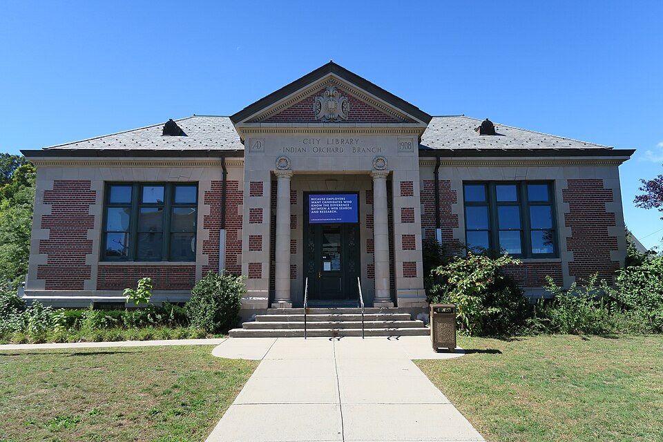
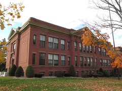
Photograph of Indian Orchard Branch Library
Photograph by John Phelan, CC BY-SA 4.0. Via Wikimedia Commons.

Indian Orchard Branch Library

Built in 1908 in the Neoclassical architecture. Listed on the National Register of Historic Places in 1999. A historic map-sheet match is not published yet. The record needs a coordinate-quality review before it can be joined to a sheet boundary.

From the record

“The Indian Orchard Branch Library is a historic branch library at 44 Oak Street in Springfield, Massachusetts. The Classic Revival building was constructed in 1909 to a design by John W.”

Wikipedia article Indian Orchard Branch Library, CC BY-SA 4.0.

one of 123 National Register listings in Hampden County · listed in 1999 · category: Building · built in 1908, Neoclassical architecture, by John W. Donohue.

Sources: the Wikipedia article · the case file at the National Archives · the National Register database, National Park Service

The listing

  • What is counted as historic. The nomination lists 1 building as contributing to the listing.
  • Address. 44 Oak St., Springfield, 01151
  • When was it listed? 1999-02-26
  • Category. building
  • Township. Springfield city
  • When was it built? 1908
  • Architectural style. Neoclassical architecture
  • Architect. John W. Donohue
  • National Register reference number. 99000258 - the number the National Park Service assigned this property when it was listed, and the key its nomination file is catalogued under at the National Archives.

The ground it stands on

126,411 words

The chapter on Springfield City in King's Handbook of Springfield, Massachusetts : a Series of Monographs, Historical and Descriptive, published 1884 names Springfield. This is what it says, exactly as the scans read.

TN making this " Handbook of Springfield," the aim has been to make a readable and trustworthy description of the city as it now is. The volume contains nearly four hundred octavo pages, with almost two hundred illustrations, nearly all of which were made expressly for this volume. At the end are full indexes comprising nineteen pages, with more than twentyseven hundred references, so that any part of the contents can be referred to instantly. The views are intended to show some of the historic, unique, and prominent features of the city. The portraits will bring to mind the faces of men who have been prominent in civil government, who have gained places in the local literary annals, or have been active in those enterprises which have brought wealth and fame to the city. No attempt has been made to furnish an elaborate history of Springfield ; yet for all practical purposes, the book contains as much history as the ordinary citizen cares to know or could well remember. It is believed that this book is the most pretentious one as yet issued of its kind, for any city of the size of Springfield, in this country. The original design was a much smaller volume ; but after the work was begun, so much interesting matter was found for the reader, and so many enthusiastic and patriotic citizens were met, that the book was materially enlarged, and many illustrations were added. It is hoped that it now will be acceptable, not only to the former and present residents, but also to those who may have occasion only to visit the city.

Passage source: King's Handbook of Springfield, Massachusetts : a Series of Monographs, Historical and Descriptive, published 1884.

It will be apparent that much valuable aid has been rendered by many well-informed citizens, most of whom are credited at the end of their respective chapters. Many persons not having furnished whole chapters ought to be mentioned here, in brief acknowledgment of their services : among them, the Rev. Dr. William Rice, the venerable city librarian; J. Newton Bagg of West Springfield ; Thomas At. Dewey, late secretary of the Business-

Passage source: King's Handbook of Springfield, Massachusetts : a Series of Monographs, Historical and Descriptive, published 1884.

Machine-read from a century-old scan, so expect the errors a machine makes: misspelled names, dropped words, stray characters.

Read the whole chapter on Springfield City - 126,411 words on its settlement, mills, schools and churches.

Fires near this property

346 since 2015

Regional context, not property-specific evidence. The federal wildfire occurrence database lists 346 fires within 5 miles of Indian Orchard Branch Library between 2015 and 2020, burning about 153 acres in total. 9 started naturally. 2 were recorded as arson. Distance is straight-line from the map coordinates, so a fire counted here may appear on a neighbouring settlement's page as well.

Reported cause Fires
Missing data/not specified/undetermined206
Equipment and vehicle use76
Debris and open burning22
Recreation and ceremony16
Smoking11
Natural9
Misuse of fire by a minor4
Arson/incendiarism2

The most recent of them, most recent first, with the day each was reported and the service that recorded it.

DateCause SizeReported by Name on the report
9 September 2015Missing data/not specified/undeterminedunder an acreMassachusetts Bureau of Forest Fire Controlnot named
8 September 2015Missing data/not specified/undeterminedunder an acreMassachusetts Bureau of Forest Fire Controlnot named
5 September 2016Missing data/not specified/undeterminedunder an acreMassachusetts Bureau of Forest Fire Controlnot named
5 September 2016Recreation and ceremonyunder an acreMassachusetts Bureau of Forest Fire Controlnot named
4 September 2018Equipment and vehicle useunder an acreMassachusetts Bureau of Forest Fire Controlnot named
4 September 2016Missing data/not specified/undeterminedunder an acreMassachusetts Bureau of Forest Fire Controlnot named
4 September 2015Equipment and vehicle useunder an acreMassachusetts Bureau of Forest Fire Controlnot named
3 September 2015Missing data/not specified/undetermined1.0 acresMassachusetts Bureau of Forest Fire Controlnot named

Every fire recorded in Hampden County

Specimens collected near this property

12 of 1,980 shown

Regional context, not property-specific evidence. Museums hold 1,980 specimens collected within 10 miles of Indian Orchard Branch Library between 1845 and 1975: 749 Animalia, 632 Fungi, 558 Plantae, 26 Chromista, 9 Unrecorded, 5 Protozoa, 1 Bacteria. 12 distinct Species records are shown. Collected by A. Albee, A. B. Seymour, A. E. Kirk and others. Each is a physical object with a catalogue number, and each entry opens the museum's record. This is what was collected and kept, not a survey of what lives here - nothing can be concluded from a species being absent.

Image SpeciesYear Collected by Where, as recorded
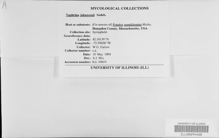
Specimen of Taphrina johansonii Sadeb.Taphrina johansonii Sadeb.1894W.G. Farlow
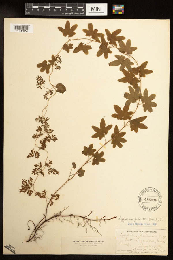
Specimen of Lygodium palmatum (Bernh.) Sw.Lygodium palmatum (Bernh.) Sw.1895Deane, WalterEast Longmeadow;;;;
Specimen of Calligrapha rhoda Knab, 1909Calligrapha rhoda Knab, 19091900F. KnabWest Springfield
A photograph of the species Galeopsis tetrahit, not of this specimenGaleopsis tetrahit L.1845not recorded
A photograph of the species Icterus galbula, not of this specimenIcterus galbula (Linnaeus, 1758)1857Collector(s): Joel Asaph AllenSpringfield
A photograph of the species Pipilo erythrophthalmus, not of this specimenPipilo erythrophthalmus erythrophthalmus (Linnaeus, 1758)1857Collector(s): Joel Asaph AllenSpringfield
A photograph of the species Setophaga aestiva, not of this specimenSetophaga aestiva aestiva (J.F.Gmelin, 1789)1857Collector(s): Joel Asaph AllenSpringfield
A photograph of the species Turdus migratorius, not of this specimenTurdus migratorius migratorius Linnaeus, 17661857Collector(s): Joel Asaph AllenSpringfield
A photograph of the species Carex platyphylla, not of this specimenCarex platyphylla J.Carey1858J. BlakeMt. Holyoke
A photograph of the species Geranium robertianum, not of this specimenGeranium robertianum L.1858not recordedMt. Holyoke
A photograph of the species Viola pubescens, not of this specimenViola pubescens Aiton1858not recordedMt. Holyoke
A photograph of the species Rhinichthys atratulus, not of this specimenRhinichthys atratulus (Hermann, 1804)1859Wheatland, R.H.Chicopee River, at Chicopee, Hampden County, Massachusetts; Locality according to historical catalogue: 'Chicopa River, Massachusetts'/erroneous, is Chicopee River, at Chicopee, Massachusetts (according to MCZ online fish catalogue).

All 1,980 specimens within 10 miles, at the Global Biodiversity Information Facility.

Mines and quarries near this property

10 of 27 shown

Regional context, not property-specific evidence. The federal mineral resources record lists 27 workings within 5 miles of Indian Orchard Branch Library: 14 past producers, 12 producers, 1 plant. 13 still produce. What was taken out: Sand and Gravel, Construction, Stone, Dimension, Flagstone, Aluminum. Distance is straight-line from the map coordinates, so a quarry counted here may appear on a neighbouring settlement's page as well.

Where SiteCommodity StatusRecorded
Clay PitBrick ClayProducerClay
Clay PitClayPast Producer
Construction Aggregates PitGranite, Stone, Crushed/BrokenProducer
Granby Quarry No 1Stone, Crushed/BrokenPast Producer
Bay State Refining Co--Chicopee, MaAluminumPlant
Chicopee PlantAluminumPast Producer
Sandstone QuarryStone, DimensionProducerSandstone
Sandstone QuarryFlagstonePast Producer

Every working recorded in Hampden County

Storms near this property

60 of 134 shown

Regional context, not property-specific evidence. The National Weather Service names Springfield, the town this property stands in, in 134 storm reports between 1993 and 2025: 69 thunderstorm wind, 41 hail, 11 flood, 6 lightning. The reports record 2 injuries. Each account below is quoted exactly as the forecast office filed it, from the NOAA Storm Events Database, and each date opens the federal record of that event.

WhenEvent Place namedHarm What the report says
July 2008Thunderstorm WindWest Springfield2 hurt, $10,000A tree on Interstate 91 near the Massachusetts Turnpike was downed by thunderstorm winds onto a car, puncturing the windshield. A 61 year old man and a 57 year old woman were injured. Rescuers had to cut through the tree before they could get to the people in the car. The man was able to climb out by himself once the tree was out of the way, but the woman had to be extricated. This also blocked both southbound lanes of Interstate 91 bringing traffic to a complete stop.
August 2013HailWest Springfield$3,000,000Quarter to half dollar size hail fell on Main Street, accumulating up to two inches in spots. A car on Fairview Avenue was damaged with numerous hail dents. There were also several reports of nickel size hail in the area of Riverdale Road. About 500 cars at the Balise family of car dealerships were damaged. Damage ranged from minimal to extensive. Further damage was found two weeks later, when heavy rain fell through small holes in the roof of Chestnut Middle School, resulting in water damage.
August 2006Thunderstorm WindWest Springfield$275,000no account filed
August 2011FloodWest Springfield$200,000After receiving three to eight inches of heavy rain from Tropical Storm Irene, flooding resulted in the closure of Route 20 in West Springfield at Sibley Avenue.
July 2011Thunderstorm WindEast Springfield$75,000Trees and wires on Berkshire Avenue, Locust, Paramount, Stuart and Brewster Streets, Wellfleet Drive, Memorial Drive, and several other streets in the Indian Orchard neighborhood were downed by thunderstorm winds. Trees fell on houses on Paramount and Brewster Streets. A person was trapped in the house on Paramount Street, but was uninjured.
May 2010Thunderstorm WindWest Springfield$75,000Multiple utility poles and trees were downed across West Springfield and Agawam, including several utility poles along Route 5 in West Springfield.
July 2011Thunderstorm WindEast Springfield$50,000Trees were downed onto several houses on Grochmal Avenue in the Indian Orchard section of Springfield. These trees fell in such a way that people were trapped inside the houses. No one was injured. Several trees in the area were also uprooted.
June 2011Thunderstorm WindEast Springfield$50,000Large trees were downed onto two houses and a car. The houses were on Quincy Street.
July 2010LightningEast Springfield$50,000A lightning strike ignited an attic fire at a house on Locust Street.
May 2010Thunderstorm WindWest Springfield$50,000The Automated Surface Observing System at Barnes Municipal Airport (KBAF) recorded a wind gust of 58 mph. In addition, many trees and wires were downed by thunderstorm winds, including a four foot diameter oak tree on Morgan Road in West Springfield. On City View Avenue in West Springfield, a tree and utility pole were downed, blocking the road. Two power poles were downed near the intersection of East Elm Street and Riverdale Road.
May 2010Thunderstorm WindSpringfield$35,000Multiple trees on Cottage and Garden Streets and Roosevelt and Berkshire Avenues were downed by thunderstorm winds.
July 2006Thunderstorm WindSpringfield$35,000no account filed
August 2018FloodSpringfield$30,000At 1:11 PM EST, water was reported entering basements on the 1300 block of Main Street in Springfield.
May 2010Thunderstorm WindWest Springfield$30,000Trees and wires were downed along Route 20 in West Springfield and in Springfield. A large tree was downed onto a house on Forest Park Avenue in Springfield.
May 2010Thunderstorm WindEast Springfield$25,000Numerous large trees were downed by thunderstorm winds.
August 2004Thunderstorm WindWest Springfield$25,000no account filed
February 2016Thunderstorm WindWest Springfield$20,000Trees on Adrian Avenue, Craiwell Avenue, Upper Beverly Street, and Sibley Avenue in West Springfield were downed by thunderstorm winds.
June 2011Thunderstorm WindWest Springfield$20,000A tree on Cold Spring Avenue was downed onto a car by thunderstorm winds.
June 2010Thunderstorm WindWest Springfield$20,000Several trees were downed across West Springfield, including one down on a car on Route 5 near Memorial Bridge and one down on Circuit Avenue. Several large limbs were also downed on Fairview Avenue.
July 2010LightningEast Springfield$20,000A lightning strike ignited a house fire on Perkins Street.
September 2008FloodWest Springfield$20,000Heavy rain associated with Tropical Storm Hanna ranged from three and a half to five and a half inches. This resulted in widespread street flooding across central Hampden County. The Union Street underpass in West Springfield was flooded. In Wilbraham, multiple roads were flooded, including Main Street and several locations on Route 20 and Route 32. Minor mudslides occurred on Route 32. Both Holyoke and Springfield experienced widespread street flooding. Route 32 and several other roads were rendered impassable by floodwaters in Monson. Several vehicles on these roads became disabled. In addition, three residences were flooded along a retention road.
July 2014Thunderstorm WindWest Springfield$15,000Trees were downed on several streets, including Park and Main. A tree was downed onto two cars on Amostown Road.
July 2008LightningEast Springfield$15,000A house on Wistaria Street was struck by lightning and caught fire.
August 2005Thunderstorm WindWest Springfield$15,000no account filed
May 2025Thunderstorm WindEast Springfield$12,000In Springfield, there was a large tree blocking Delmore St. There was a large tree on two houses on Jeffery St. There was a tree down on a house near Allen St. There was a tree down on a house near Providence St. There was a tree down near Peekskill Ave.
May 2006Thunderstorm WindWest Springfield$12,000no account filed
July 2022Thunderstorm WindEast Springfield$10,000In Springfield, a large tree was down on cars on Brookdale Drive. Photo shared on Twitter.
July 2014Thunderstorm WindWest Springfield$10,000Trees on Highland Avenue were downed by thunderstorm winds.
July 2014Thunderstorm WindWest Springfield$10,000A tree on High Street was downed by thunderstorm winds, blocking the road. Trees and wires along Prospect Avenue were downed as well.
July 2014Thunderstorm WindEast Springfield$10,000A large tree was downed onto a house on Ambrose Street. Wires were downed on Prospect Avenue and Hunter's Place.
August 2013Thunderstorm WindWest Springfield$10,000A tree was downed onto a car on Elm Street in West Springfield. In addition, a window was broken on Main Street, presumable from the windblown large hail.
May 2010Thunderstorm WindWest Springfield$10,000Trees on Cooper Street were downed by thunderstorm winds.
July 2008Thunderstorm WindEast Springfield$10,000Trees and wires in the Porter Lake area, including Berkshire Avenue and River Street, were downed by thunderstorm winds. One of these trees was downed onto a car.
June 2006Thunderstorm WindSpringfield$10,000no account filed
May 2006Thunderstorm WindWest Springfield$10,000no account filed
July 2002Thunderstorm WindWest Springfield$10,000no account filed
August 2021Thunderstorm WindWest Springfield$8,000In West Springfield, there were numerous trees downed by an isolated severe thunderstorm. On Elm Street there was a six-inch branch down. Trees were down on Woodmont Street and on Amostown Road at Fausey Drive. A large tree and wires were down on Piper Road. A large tree was down on a house on Churchill Street. Wires were down on on Vincent Drive, Morgan Road, and Smyrna Street.
October 2008FloodSpringfield$8,000Heavy rain fell across Hampden County. Up to two feet of water collected in several locations in Springfield and West Springfield, including Cambridge Street and Route 5. Several cars flooded out.
July 2021Thunderstorm WindWest Springfield$6,000In West Springfield, a utility pole was down on Route 20 at Dewey Street. A tree was down on wires on Birnie Avenue.
August 2024Thunderstorm WindSpringfield$5,000In Springfield, a tree fell down on a car on Dwight St. The person inside was freed and was ok.
July 2018Flash FloodWest Springfield$5,000At 2 PM EST, a thunderstorm moving over Westfield and West Springfield created downpours over the area. A car was trapped in flood waters on Old Westfield Road in West Springfield.
July 2018Flash FloodWest Springfield$5,000At 2:10 PM EST, heavy rain from a thunderstorm flooded and closed U.S.Route 20 in Westfield at the intersection with East Mountain Road. A car was trapped in the flood waters.
August 2016Thunderstorm WindWest Springfield$5,000A tree at the corner of Main Street and Burford Avenue was downed by thunderstorm winds.
July 2014Thunderstorm WindEast Springfield$5,000A large tree was downed onto a home on Ambrose Street.
August 2012FloodWest Springfield$5,000One car was stuck at a restaurant on Route 5. Water was up to the floor boards of another car on Prospect Street. The Automated Surface Observing System at Barnes Municipal Airport (KBAF) recorded 1.14 inches of rain in 20 minutes and a total of just under 1.50 inches.
August 2012FloodWest Springfield$5,000In West Springfield, West School Street was flooded and impassable. The River Street underpass also was flooded with a car stuck in the floodwaters. Meadow Street in Agawam was flooded and impassable.
June 2010Thunderstorm WindEast Springfield$5,000A tree and wires on Chestnut Street were downed by thunderstorm winds.
August 2009Thunderstorm WindEast Springfield$5,000A tree and large limbs on Paxton Road and Riverdale Street were downed by thunderstorm winds.
August 2008LightningEast Springfield$5,000Lightning struck a garage on Menthuen Street resulting in a fire.
August 2006Thunderstorm WindWest Springfield$5,000no account filed
June 2005LightningSpringfield$5,000no account filed
August 2005Thunderstorm WindWest Springfield$5,000no account filed
August 2005HailSpringfield$5,000no account filed
October 2020Thunderstorm WindEast Springfield$4,000In Springfield, a tree was down on Liberty Street. A tree and wires were down on Birchland Avenue. A tree split and landed on a house on Jeffrey Road.
July 2006FloodSpringfield$4,000no account filed
August 2020LightningEast Springfield$2,000In Springfield, lightning struck a house causing a fire on White St.
July 2019Thunderstorm WindEast Springfield$2,000A tree was downed on wires on Route 5 and Route 91.
May 2002Thunderstorm WindSpringfield$2,000no account filed
July 2002Thunderstorm WindSpringfield$2,000no account filed

Every storm recorded in Hampden County

Newspapers printed here

0 digitised pages

2 papers published in this town, digitised by the Library of Congress and free to read: 0 issues, 0 pages. Every page is searchable, so a name or a street can be looked for directly in what the town printed about itself at the time.

NewspaperPublished
Springfield Weekly Republican1851 to 1946
Springfield Republican1838 to 1851

Map coverage status

No historic map-sheet match is published for this property yet. That does not mean no map exists. This record needs a coordinate-quality review before it can be joined to a sheet boundary. Browse the county's mapped places while that work is pending.

From the nomination file

7,567 words on record

When this property was proposed for the National Register, someone wrote the case for it: what the building is, and why it matters. That document is a federal record in the public domain. It is quoted below word for word, never summarised. The text was read off the scanned case file by machine, so the occasional stray character is the recogniser's and the 1970s typewriter's.

Statement of significance

Applicable National Register Criteria (Mark "x" in one or more boxes for the criteria qualifying the property for National Register listing.) X A Property is associated with events that have made a significant contribution to the broad patterns of our history. _B Property is associated with the lives of persons significant in our past. X C Property embodies the distinctive characteristics of a type, period, ormethod of construction or represents the work of a master, or possesses high artistic values, or represents a significant and distinguishable entity whose components lack individual distinction. _D Property has yielded, or is likely to yield, information important in prehistory or history.

Criteria Considerations (Mark "x" in all the boxes that apply.) Property is: _A owned by religious institution or used for religious purposes. _ B removed from its original location. _ C a birthplace or grave. _ D a cemetery. _ E a reconstructed building, object, or structure. _F a commemorative property. _G less than 50 years of age or achieved significance within the past 50 years.

Narrative Statement of Significance (Explain the significance of the property on one or more continuation sheets.) Hampden, MA County and State Areas of Significance (Enter categories from instructions) ARCHITECTURE COMMUNITY PLANNING AND DEVELOPMENT EDUCATION Period of Significance 1909-1948 Significant Dates 1909 Significant Person (Complete if Criterion B is marked above) N/A Cultural Affiliation N/A Architect/Builder DONOHUE, JOHN WILLLIAM 9.

The whole case file for this property - 7,567 words, 34 pages, reproduced complete.

Quoted from the National Register nomination for reference 99000258, 34 pages, held by the National Archives in Record Group 79. See the catalogue record.

Listed places nearby

6 within 8 miles

Other National Register properties close enough to walk or drive between, ordered by distance from this one. Both positions come from the same geocoding pass that matched these properties to their map sheets.

Sources for this property

National Archives recordThe nomination case file for reference 99000258 in Record Group 79.
Wikipedia articleCommunity-written account of this property, licensed CC BY-SA.
Hampden CountyAll 123 listed properties in this county.

Provenance

  • Listing record. National Park Service National Register of Historic Places, listed-properties dataset, current to 2026-05-22.
  • Map join. Address geocoded through the United States Census geocoder, then tested against the published boundary of every sheet in the USGS Historical Topographic Map Collection.
  • How this page is made. Listing fields come from federal records; map-sheet coverage is a labelled coordinate-to-boundary calculation, not a source-field claim.
  • Wildfire. Short, Karen C. 2022. Spatial wildfire occurrence data for the United States, 1992-2020 [FPA_FOD_20221014]. 6th Edition. Fort Collins, CO: Forest Service Research Data Archive. https://doi.org/10.2737/RDS-2013-0009.6 Collected with United States Government funding and usable without additional permissions or fees.
  • Specimens. Global Biodiversity Information Facility (GBIF), https://www.gbif.org/. Only records licensed CC0 or CC BY are used. Records licensed CC BY-NC are excluded because this site carries advertising. Images are checked individually and any whose licence is non-commercial, no-derivatives or unreadable is refused.
  • Mines and quarries. USGS Mineral Resources Data System (MRDS) https://mrdata.usgs.gov/mrds/ A work of the United States government, no copyright under 17 U.S.C. 105.
  • Storms. NOAA National Centers for Environmental Information, Storm Events Database https://www.ncei.noaa.gov/stormevents/ A work of the United States government, no copyright under 17 U.S.C. 105. Narratives are quoted verbatim from the National Weather Service report and are not edited or summarised.