 Block
From the record
9 National Register listings published here.
Sources: the National Register database, National Park Service
15 topographic sheets cover 5 settlements here, and 9 properties are on the National Register of Historic Places.
9 National Register listings published here.
Sources: the National Register database, National Park Service
Every property in this county listed on the National Register of Historic Places, with the year it was listed and the federal nomination document.
| Photograph | Property | Type | Listed | Reference |
|---|---|---|---|---|
 | Aurora County Courthouse | building | 1993 | 92001855 |
 | Hilton House | building | 2000 | 00001352 |
 | Hofmeister House | building | 2007 | 06001307 |
 | Lincoln House | building | 2002 | 02000023 |
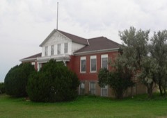 | Patten Consolidated School | building | 2008 | 08000797 |
 | Raesly House | building | 2004 | 04000472 |
 | William P. Smith House | building | 2004 | 04000471 |
 | Sweep Hotel | building | 2005 | 05000033 |
 | Underwood United Methodist Church | building | 2008 | 08000798 |
Every wildfire the federal occurrence database records inside this county: 162 of them, burning about 11,644 acres. 12 started naturally and none was recorded as arson. Each settlement page carries the fires within five miles of it.
| Reported cause | Fires |
|---|---|
| Missing data/not specified/undetermined | 82 |
| Equipment and vehicle use | 32 |
| Debris and open burning | 30 |
| Natural | 12 |
| Railroad operations and maintenance | 3 |
| Smoking | 2 |
| Other causes | 1 |
The five largest, by the area the report gives. None of them was recorded as arson.
| Date | Cause | Size | Reported by | Name on the report |
|---|---|---|---|---|
| 2 February 2002 | Equipment and vehicle use | 7,000 acres | Plankinton Volunteer Fire Department | RUSSELL EHLERS |
| 28 July 2006 | Equipment and vehicle use | 750 acres | South Dakota Wildland Fire Suppression | not named |
| 28 July 2006 | Equipment and vehicle use | 700 acres | South Dakota Wildland Fire Suppression | AMICK |
| 11 January 2000 | Debris and open burning | 400 acres | Plankinton Volunteer Fire Department | NINETEEN |
| 21 October 2014 | Missing data/not specified/undetermined | 350 acres | South Dakota Wildland Fire Suppression | HORNING BEAN FIRE |
| 6 October 2011 | Equipment and vehicle use | 250 acres | South Dakota Wildland Fire Suppression | COMBINE WIRING |
| 8 April 2016 | Missing data/not specified/undetermined | 220 acres | South Dakota Wildland Fire Suppression | TENHIGH |
| 9 April 2012 | Missing data/not specified/undetermined | 200 acres | South Dakota Wildland Fire Suppression | CONTROLLED BURN BY FD |
Every settlement page carries the fires within five miles of it - see the settlement index below.
The NOAA Storm Events Database holds 306 reports for this county, causing no deaths, 1 injury and about $5,554,500 in recorded property damage. Each settlement page carries the reports that name it.
| Kind of event | Reports |
|---|---|
| Hail | 152 |
| Thunderstorm Wind | 114 |
| Tornado | 16 |
| Flood | 14 |
| Flash Flood | 6 |
| Funnel Cloud | 2 |
| Lightning | 1 |
| Heavy Rain | 1 |
The most serious of them, by death, then injury, then recorded damage. The accounts are quoted exactly as the forecast office filed them.
| When | Event | Place named | Harm | What the report says |
|---|---|---|---|---|
| July 1973 | Tornado (F1) | not stated | 1 hurt, $25,000 | no account filed |
| June 2024 | Flood | Aurora Center | $2,540,000 | Rainfall amounts across Aurora County from June 20-22 ranged from 3 to 9 inches. Widespread overland flooding ensued. ||Numerous county and township roads were impacted by flood waters and closed. Interstate 90 was closed near the Aurora/Davison County line and South Dakota Highway 16 was closed in multiple areas parallel to the interstate. Preliminary damage assessments estimate there to be 1.93 million dollars in damage to public infrastructure. ||Multiple structures were impacted by backed up water or sewage. Four residences reported damage in White Lake, estimated at a cost of 31 thousand dollars. Eighteen residences and 4 businesses in Plankinton reported damage, estimated at a cost of 582 thousand dollars. |
| September 2019 | Flood | Aurora Center | $709,000 | Around 80 percent of Aurora County experienced water over county and township roads, with the greatest impacts over the southern half of the county. Travel was not recommended from Thursday through Sunday. Interstate 90 was briefly closed between Plankinton and Mount Vernon due to areas of water across the roadway. Property damage costs include damage to public infrastructure. |
| March 2019 | Flood | Plankinton | $600,000 | Snow melt and heavy rainfall (measured 1.80 inches at White Lake) resulted in significant flooding of agricultural lands and inundation of county roads as Firesteel Creek near Mount Vernon (gage site MTVS2) reached moderate flood stage, cresting 6.44 feet above flood stage on March 22. |
| March 2019 | Flood | Aurora Center | $600,000 | Flooding resulted in extensive damage to public infrastructure including numerous county and township roads, culverts, and some bridges. The property damage costs include estimates for public property losses. |
| May 2007 | Tornado (EF3) | Plankinton | $300,000 | A tornado destroyed a hunting lodge and nearby outbuildings. The tornado also severely damaged a house, tossed a trailer 100 yards, and caused tree damage. |
| June 2000 | Thunderstorm Wind | White Lake | $200,000 | Thunderstorm winds partly or totally destroyed numerous farm buildings, moved a large semi-truck 30 feet, blew another semi-truck into a ditch, caused widespread tree and power line damage including 2 foot diameter trees blown down, and damaged homes and vehicles, mainly with flying debris. Power outages resulted from the power lines and poles being blown down. |
| August 2009 | Hail | Aurora Center | $100,000 | Large hail dented vehicles, broke windows on vehicles and buildings, and damaged siding. The Aurora Center Reformed Church suffered considerable damage, resulting in the need to board the broken windows for Sunday service the next day. The hail also damaged crops, mainly corn. The amount of crop damage was not known. |
| July 2000 | Thunderstorm Wind | White Lake | $100,000 | Thunderstorm winds caused widespread tree damage and also damaged at least two buildings. |
| September 2019 | Thunderstorm Wind | Stickney Arpt | $50,000 | An empty metal grain bin was blown apart by thunderstorm winds. |
| June 2010 | Thunderstorm Wind | White Lake | $40,000 | Thunderstorm winds blew the roof off a house and heavily damaged the adjoining garage. The winds also blew out car windows and caused tree damage, including several trees blown down. |
| June 2020 | Thunderstorm Wind | Stickney | $35,000 | A pole barn was significantly damaged. Property damage costs are rough estimates. |
| June 2020 | Thunderstorm Wind | Stickney | $30,000 | Extensive damage occurred to a grain bin, with minor damage done to the roof of a pole barn. Property damage costs are rough estimates. |
| June 2020 | Thunderstorm Wind | Stickney | $25,000 | Cattle and calf shelters were damaged. Several calves were killed. Property damage costs are rough estimates. |
| September 2019 | Flood | Plankinton | $25,000 | Firesteel Creek near Mount Vernon (gage site MTVS2) responded sharply to 5 to 9 inches of rainfall between September 10-12 (6.49 inches at White Lake, 5.68 inches near Stickney and 7.83 inches 5 miles west southwest of Mitchell) to reach the sixth highest crest on record at 7.17 feet above flood stage on September 13. Innumerable county and township roads were inundated and damaged, along with extensive agricultural flooding. |
| July 1986 | Tornado (F2) | not stated | $25,000 | no account filed |
| July 2020 | Thunderstorm Wind | Aurora Center | $20,000 | An anchored play set and gazebo were destroyed. Several large limbs were also downed by the strong winds. Minor damage occurred to house skirting and siding. Property damage amounts are rough estimates. Crop damage is an estimate from insured losses. Information provided by the United States Department of Agriculture. |
| July 2019 | Thunderstorm Wind | Stickney | $20,000 | Extensive tree damage in Stickney. A tree fell onto power lines near a transformer, causing a power outage in town. |
| July 1999 | Thunderstorm Wind | White Lake | $20,000 | no account filed |
| July 2017 | Hail | Plankinton | $10,000 | Hail, blown by 65 to 75 mph winds, caused considerable damage to vehicle windshields on Interstate 90. |
| July 2017 | Thunderstorm Wind | Plankinton | $10,000 | Broken windshields causing by wind blown hail along Interstate 90 between mile markers 305 and 308. |
| July 2009 | Hail | Plankinton | $10,000 | Large hail covered the ground and severely damaged crops. The amount of crop damage was not known. The hail also damaged windows on a home and vehicles, and dented vehicles. The hail was accompanied by damaging winds. |
| July 2009 | Thunderstorm Wind | Plankinton | $10,000 | Thunderstorm winds destroyed a hog barn, killing one sheep and injuring several others. The winds also blew off shingles from a barn and caused tree damage. The winds contributed to crop damage caused by accompanying large hail. |
| June 2008 | Thunderstorm Wind | Stickney | $10,000 | Thunderstorm winds tipped over a semi trailer, blew feed bunks 100 yards, and blew down several trees. |
| August 2004 | Thunderstorm Wind | Plankinton | $10,000 | Thunderstorm winds caused tree damage, including a large tree blown onto a trailer. |
| June 1997 | Thunderstorm Wind | White Lake | $10,000 | no account filed |
| June 2020 | Flash Flood | Stickney | $5,000 | Several county roads were flooded. Rainfall overnight and through the morning totalled 3.94 inches at Corsica and 3.33 inches 10 miles west of Dimock. Property damage costs are rough estimates. |
| August 2015 | Thunderstorm Wind | Storla | $5,000 | Thunderstorm winds blew down up to 4 inch diameter trees and branches, and also blew down power lines. |
| June 2015 | Thunderstorm Wind | Storla | $5,000 | Thunderstorm winds rolled over a trailer home and caused tree damage. |
| September 2012 | Thunderstorm Wind | Plankinton | $2,000 | Thunderstorm winds blew down trees, blew doors off a barn, and damaged railroad ties in fencing. |
| September 2019 | Thunderstorm Wind | Stickney | $1,000 | Strong winds blew pickup truck sideways and downed several larger limbs. |
| June 2013 | Thunderstorm Wind | Storla | $1,000 | Thunderstorm winds snapped a power pole. |
| July 2001 | Lightning | Plankinton | $1,000 | Lightning started a fire that destroyed 15 large round hay bales. |
| September 2019 | Thunderstorm Wind | Aurora Center | $250 | Thunderstorm winds broke several limbs of 4 to 6 inches in diameter. |
| September 2019 | Thunderstorm Wind | Stickney | $250 | Thunderstorms winds removed several tree limbs to 3 inches diameter. |
| July 2025 | Thunderstorm Wind | Plankinton | - | Thunderstorm winds downed several 3-to-4-inch diameter tree branches across Plankinton. |
| July 2025 | Thunderstorm Wind | Plankinton | - | Thunderstorm wind gusts were measured by a personal weather station. |
| July 2025 | Thunderstorm Wind | Plankinton | - | Thunderstorm wind gusts were measured by a Road Weather Information System sensor near Plankinton. |
| July 2025 | Funnel Cloud | White Lake | - | A funnel cloud developed over White Lake. |
| August 2025 | Thunderstorm Wind | Plankinton | - | A second distinct period of severe thunderstorm wind gusts were measured by a Road Weather Information System sensor 5 miles west of Plankinton. |
| August 2025 | Thunderstorm Wind | White Lake | - | A full-sized tree with an estimated diameter of at least 16 inches was broken in half. Some minor building damage occurred from the thunderstorm wind gusts. |
| August 2025 | Hail | Aurora Center | - | Hail ranged in size up to quarter size. |
| August 2025 | Thunderstorm Wind | White Lake | - | An extended period of thunderstorm severe wind gusts were measured by South Dakota Mesonet station WTES2 White Lake. |
| August 2025 | Thunderstorm Wind | Plankinton | - | Thunderstorm wind gusts were measured by a Road Weather Information System sensor 5 miles west of Plankinton. |
| August 2025 | Thunderstorm Wind | Plankinton | - | Thunderstorm wind gusts were measured by a personal weather station 3 miles northeast of Plankinton. |
| July 2025 | Thunderstorm Wind | Plankinton | - | The emergency manager measured a thunderstorm wind gust of 70 mph. |
| July 2025 | Thunderstorm Wind | Aurora Center | - | The emergency manager measured a thunderstorm wind gust of 73 mph. |
| June 2025 | Thunderstorm Wind | Plankinton | - | An extended period of severe wind gusts measured by South Dakota RWIS site near Plankinton. |
| June 2025 | Thunderstorm Wind | Stickney | - | Several 4 inch diameter tree limbs were downed by thunderstorm winds. |
| June 2025 | Thunderstorm Wind | Plankinton | - | Winds were measured by a personal weather station, with a peak gust at 2041 CST. |
| June 2025 | Hail | Aurora Center | - | Hail was mostly pea to dime size, but a few stones were as big as a nickel. |
| July 2024 | Thunderstorm Wind | Plankinton | - | Thunderstorm wind gusts peaked at 64 mph at 155 am CST at the South Dakota Road Weather Information System site near Plankinton. |
| July 2024 | Thunderstorm Wind | Aurora Center | - | A large cottonwood tree fell on a pickup. Numerous large branches were blown down across the yard. |
| June 2024 | Flash Flood | Plankinton | - | Early evening rainfall was intense with 2 to 2.5 inches in a couple of hours, which resulted in widespread flash flooding in Plankinton. For a more comprehensive description of flood damage, please see other entries for areal and river flooding for Aurora County. |
| June 2024 | Flash Flood | Plankinton | - | Continued rainfall exacerbated flooding of roads with numerous barricaded and impassable. Several homes had flooded basements. For a more comprehensive description of flood damage, please see other entries for areal and river flooding for Aurora County. |
| June 2024 | Flood | Plankinton | - | Firesteel Creek near Mount Vernon rose above flood stage the evening of June 21st, cresting around 8.94 feet above flood stage (16.94 feet) on June 22nd. This crest is in the Major Stage. The creek then fell below flood stage on the afternoon of June 27th. For a more comprehensive description of flood damage, please see other entries for Aurora County. |
| July 2023 | Thunderstorm Wind | Stickney | - | Thunderstorm wind gusts as high as 63 mph were measured by a personal weather station 5 miles north-northeast of Stickney. |
| July 2023 | Thunderstorm Wind | Stickney | - | Thunderstorm winds were measured by a personal weather station 5 miles north-northeast of Stickney. |
| July 2023 | Thunderstorm Wind | Plankinton | - | Thunderstorm wind gusts as high as 60 mph were measured by South Dakota Road Weather Information System site SD533 4 miles west of Plankinton. |
| July 2023 | Hail | Storla | - | Crop damage is an estimate from insured losses. Information provided by the United States Department of Agriculture. |
The Survey's mineral resources record lists 3 workings inside this county. 2 still produce and 1 is closed or unrecorded. Each settlement page carries the workings within five miles of it.
| Commodity | Workings |
|---|---|
| Sand and Gravel, Construction | 3 |
The least common of them first, because a county's hundredth gravel pit says nothing its first ten did not.
| Where | Site | Commodity | Status | Recorded |
|---|---|---|---|---|
| Alten Pit | Sand and Gravel, Construction | Unknown | ||
| Markhardt Pit | Sand and Gravel, Construction | Producer | ||
| Robby Sand & Gravel Pit | Sand and Gravel, Construction | Producer |
Named settlements recorded in the Geographic Names Information System, each with the topographic sheets covering it. Villages, hamlets and abandoned places alike. Each is shown with the nearest named watercourse or landform and the survey quadrangle it falls on.