 Block
From the record
4 National Register listings published here.
Sources: the National Register database, National Park Service
38 topographic sheets cover 18 settlements here, and 4 properties are on the National Register of Historic Places.
4 National Register listings published here.
Sources: the National Register database, National Park Service
Every property in this county listed on the National Register of Historic Places, with the year it was listed and the federal nomination document.
| Photograph | Property | Type | Listed | Reference |
|---|---|---|---|---|
| Harding Schoolhouse | building | 1989 | 89000832 | |
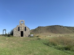 | Holy Spirit Chapel | building | 1995 | 95000817 |
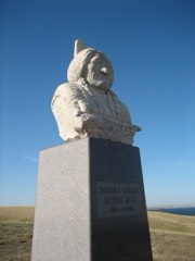 | Sitting Bull Monument | object | 2006 | 06001008 |
| South Dakota Dept. of Transportation Bridge No. 16-570-054 | structure | 1993 | 93001279 |
Every wildfire the federal occurrence database records inside this county: 1,608 of them, burning about 109,442 acres. 271 started naturally and 196 were recorded as arson. Each settlement page carries the fires within five miles of it.
| Reported cause | Fires |
|---|---|
| Missing data/not specified/undetermined | 344 |
| Natural | 271 |
| Equipment and vehicle use | 256 |
| Arson/incendiarism | 196 |
| Fireworks | 163 |
| Debris and open burning | 161 |
| Misuse of fire by a minor | 111 |
| Other causes | 42 |
| Power generation/transmission/distribution | 19 |
| Recreation and ceremony | 18 |
| Smoking | 13 |
| Railroad operations and maintenance | 13 |
| Firearms and explosives use | 1 |
The five largest, by the area the report gives. None of them was recorded as arson.
| Date | Cause | Size | Reported by | Name on the report |
|---|---|---|---|---|
| 21 October 2000 | Missing data/not specified/undetermined | 12,000 acres | Standing Rock Agency | TRIBLE |
| 18 July 2006 | Natural | 10,691 acres | Standing Rock Agency | STONE MAN CHURCH |
| 28 July 2006 | Natural | 8,060 acres | Standing Rock Agency | LIGHTNING COMPLEX |
| 19 July 2006 | Natural | 7,829 acres | Dakota Prairie National Grasslands | BLACK HORSE CREEK |
| 31 October 1999 | Power generation/transmission/distribution | 6,500 acres | Isabel Volunteer Fire Department | PAT PETERSON |
| 31 October 1999 | Power generation/transmission/distribution | 5,703 acres | Standing Rock Agency | HELLSGALE |
| 19 September 2000 | Missing data/not specified/undetermined | 5,300 acres | Standing Rock Agency | FTMANUEL |
| 17 September 2000 | Natural | 5,000 acres | Meadow Volunteer Fire Department | MILES |
Every settlement page carries the fires within five miles of it - see the settlement index below.
The NOAA Storm Events Database holds 626 reports for this county, causing no deaths, 4 injuries and about $407,780 in recorded property damage. Each settlement page carries the reports that name it.
| Kind of event | Reports |
|---|---|
| Hail | 310 |
| Thunderstorm Wind | 235 |
| Flood | 36 |
| Tornado | 23 |
| Flash Flood | 14 |
| Funnel Cloud | 4 |
| Wildfire | 3 |
| Lightning | 1 |
The most serious of them, by death, then injury, then recorded damage. The accounts are quoted exactly as the forecast office filed them.
| When | Event | Place named | Harm | What the report says |
|---|---|---|---|---|
| May 1953 | Tornado (F2) | not stated | 2 hurt, $250,000 | no account filed |
| April 1955 | Tornado (F0) | not stated | 2 hurt, $2,500 | no account filed |
| July 1994 | Thunderstorm Wind | McLaughlin | $50,000 | Hail broke some windows and damaged crops, while strong winds demolished a shed and part of a catwalk and blew down numerous tree limbs and branches. The damage occurred on the edge of a swath that extended largely north of the northern border of South Dakota. Most of the damage in South Dakota occured in or near Lemmon. |
| July 1994 | Hail | Perkins and | $50,000 | Hail broke some windows and damaged crops, while strong winds demolished a shed and part of a catwalk and blew down numerous tree limbs and branches. The damage occurred on the edge of a swath that extended largely north of the northern border of South Dakota. Most of the damage in South Dakota occured in or near Lemmon. |
| March 2009 | Flood | Wakpala | $50,000 | no account filed |
| August 1993 | Thunderstorm Wind | not stated | $5,000 | Strong thunderstorm winds damaged tents at a fair. |
| April 1955 | Tornado (F0) | not stated | $250 | no account filed |
| June 1983 | Tornado (F0) | not stated | $30 | no account filed |
| May 2025 | Thunderstorm Wind | Watauga | - | A farmer estimated winds at 60 mph but no damage was noted. |
| June 2025 | Thunderstorm Wind | Black Horse | - | The caller states that estimated wind gusts to 60 mph caused some wind driven small hail damage. |
| June 2025 | Thunderstorm Wind | Mc Intosh | - | A trained spotter estimated thunderstorm winds topped out at about 70 mph. |
| June 2025 | Thunderstorm Wind | Mc Laughlin | - | A trained spotter estimates wind gusts topped out at 60 mph. |
| September 2025 | Tornado (EFU) | Wakpala | - | Storm chasers reported a brief tornado touchdown over open land, roughly 8 miles northeast of Wakpala, SD. No damage was reported. |
| May 2024 | Thunderstorm Wind | Watauga | - | A trained spotted estimated wind gusts at 60 mph. |
| June 2023 | Thunderstorm Wind | Morristown | - | A personal weather station 6 miles south of Morristown recorded a wind gust of 70 mph. |
| June 2023 | Flood | Wakpala | - | Oak Creek near Wakpala, at the WKPS2 gauge, rose into minor flood stage of 10.0 feet at 3:00 pm MDT on June 25th, crested at 11.8 feet at 7:45 pm MDT on the 25th, and then fell below flood stage at 7:15 am MDT on the 26th. Agricultural land was impacted. |
| June 2023 | Thunderstorm Wind | Mc Laughlin | - | A personal weather station 6 miles west-southwest of McLaughlin recorded a wind gust of 62 mph. |
| September 2023 | Thunderstorm Wind | Mahto | - | Thunderstorm winds downed several tree branches at a residence 8 miles northwest of Kenel, SD which sits just south of the North Dakota state line. Another residence just over the border had siding removed by these strong winds. |
| September 2023 | Thunderstorm Wind | Morristown | - | Thunderstorm winds downed trees and power lines at a residence 5 miles south of Morristown. The power outage from wind damage to power lines extended back to the northwest as far as Keldron, SD. |
| May 2022 | Thunderstorm Wind | Trail City | - | A fire department employee estimated 70 mph wind gusts, which downed a nearby large cottonwood tree. |
| June 2022 | Thunderstorm Wind | Maple Leaf | - | Severe winds damaged a garage door. |
| July 2022 | Thunderstorm Wind | Black Horse | - | The public reported many trees uprooted. |
| June 2022 | Thunderstorm Wind | Watauga | - | Estimated 60 mph winds blew dirt and moved hay bales. The time of the peak wind was estimated based on radar. |
| July 2022 | Thunderstorm Wind | Black Horse | - | The public reported extensive damage to a large outdoor storage building due to high winds. |
| August 2021 | Thunderstorm Wind | Little Eagle | - | Sixty mph winds were estimated. |
| August 2021 | Thunderstorm Wind | Walker | - | Estimated 60 mph winds blew down a tree limb. |
| August 2021 | Thunderstorm Wind | Bullhead | - | Estimated 100 mph winds took the roof off a barn. A nearby mesonet station recorded a wind gust of over 100 mph. |
| August 2021 | Thunderstorm Wind | Bullhead | - | Estimated 100 mph winds took shingles off a home and tin off an outbuilding along with downing many large tree branches. A nearby mesonet station recorded a wind gust of over 100 mph. |
| June 2021 | Tornado (EF0) | Little Eagle | - | A tornado touched down and tracked northeast briefly in eastern Corson County. No damage was reported. |
| June 2021 | Flash Flood | Black Horse | - | Thunderstorms produced very heavy rains of up to 10.35 inches 4 miles north of Firesteel in central Corson County during the evening hours of June 8th. As a result, water ran over a county road, stock dams were overtopped and planted fields were completely washed out. Several reports of flooded basements were also documented. |
| June 2021 | Thunderstorm Wind | Black Horse | - | Small tree limbs were downed by estimated sixty mph winds. |
| July 2020 | Thunderstorm Wind | Trail City | - | Estimated sixty-five mph winds occurred. |
| July 2020 | Thunderstorm Wind | Keldron | - | Estimated eighty mph winds knocked some trees and branches down. |
| July 2020 | Thunderstorm Wind | Morristown | - | Estimated seventy mph winds downed several trees and many limbs. |
| July 2020 | Thunderstorm Wind | Morristown | - | Estimated sixty mph winds brought some tree limbs down along with moving a children's playhouse across the road. |
| August 2020 | Thunderstorm Wind | Keldron | - | Estimated sixty mph winds downed some large tree branches onto power lines causing power outages. |
| August 2020 | Thunderstorm Wind | Morristown | - | Estimated seventy mph winds downed several trees and took out the power in the house. |
| June 2020 | Thunderstorm Wind | Mahto | - | Sixty mph winds were estimated. |
| June 2020 | Thunderstorm Wind | Morristown | - | An estimated sixty mph wind downed an olive tree. |
| March 2019 | Flood | Thunder Hawk | - | Many roads were flooded in the county and on the Standing Rock Indian Reservation. |
| June 2019 | Thunderstorm Wind | Athboy | - | Sixty mph winds brought several branches down. |
| August 2019 | Hail | Little Eagle | - | Large hail and severe winds began a destructive path of crop and grassland damage from near Little Eagle and to the southeast before moving into eastern Dewey county. |
| August 2019 | Thunderstorm Wind | Watauga | - | Sixty mph winds were estimated. |
| August 2019 | Hail | Trail City | - | Quarter size hail piled up to near 5 inches in spots with the corn stripped. |
| August 2019 | Hail | Trail City | - | Quarter size hail stripped a lot of corn. |
| September 2019 | Thunderstorm Wind | Mc Intosh | - | Estimated seventy mph winds downed some trees in Mcintosh. |
| July 2019 | Thunderstorm Wind | Thunder Hawk | - | Estimated sixty-five mph winds downed many branches. |
| July 2018 | Thunderstorm Wind | Maple Leaf | - | An empty semi trailer was tipped over by estimated seventy-five mph winds. |
| July 2018 | Flash Flood | Little Eagle | - | Heavy rain caused flash flooding of the streets in and near Little Eagle. |
| July 2018 | Thunderstorm Wind | Mahto | - | Numerous trees were downed by estimated eighty mph winds. |
| July 2018 | Flash Flood | Wakpala | - | Very heavy rains caused flash flooding on Oak Creek near Wakpala. Oak creek rose 10 feet in a short period of time reaching 15 feet in the early morning. The creek then crested at 16.34 feet in the mid morning hours to just over major flood stage. Oak Creek then fell slowly into the afternoon and evening hours to below flood stage. Some agricultural land and roads were flooded. |
| June 2018 | Thunderstorm Wind | Keldron | - | An estimated seventy mph wind damaged a small 5 by 5 foot deck attached to the house. |
| June 2018 | Thunderstorm Wind | Little Eagle | - | Sixty mph winds were estimated. |
| July 2017 | Thunderstorm Wind | Trail City | - | Sixty mph winds were estimated. |
| July 2017 | Thunderstorm Wind | Athboy | - | Sixty mph winds were estimated. |
| July 2017 | Hail | Black Horse | - | Ping pong sized hail damaged or destroyed some crops. |
| June 2016 | Thunderstorm Wind | Athboy | - | Eighty mph winds pushed over a semi truck and trailer along with moving some farm equipment slightly from its original position. Some heavy steel feeders were also moved from 250 to 500 yards. |
| August 2016 | Thunderstorm Wind | Mc Intosh | - | Seventy-five mph winds brought many power poles down from Mcintosh to several miles south on Highway 65. A Quonset was also blown across Highway 65. |
| August 2016 | Thunderstorm Wind | Little Eagle | - | Sixty mph winds were estimated. |
| July 2016 | Thunderstorm Wind | Morristown | - | Sixty mph winds were estimated. |
The Survey's mineral resources record lists 10 workings inside this county. 3 still produce and 7 are closed or unrecorded. Each settlement page carries the workings within five miles of it.
| Commodity | Workings |
|---|---|
| Sand and Gravel, Construction | 10 |
The least common of them first, because a county's hundredth gravel pit says nothing its first ten did not.
| Where | Site | Commodity | Status | Recorded |
|---|---|---|---|---|
| Gravel Pit | Sand and Gravel, Construction | Past Producer | ||
| Gravel Pit | Sand and Gravel, Construction | Past Producer | ||
| Gravel Pit | Sand and Gravel, Construction | Past Producer | ||
| Gravel Pit | Sand and Gravel, Construction | Past Producer | ||
| Gravel Pit | Sand and Gravel, Construction | Past Producer | ||
| Gravel Pit | Sand and Gravel, Construction | Past Producer | ||
| Gravel Pit | Sand and Gravel, Construction | Past Producer | ||
| Sdg - Morristown Quad - Deposit 5 | Sand and Gravel, Construction | Producer | TERRACE | |
| Sdg - Morristown Quad - Deposit 6 | Sand and Gravel, Construction | Producer | TERRACE | |
| Sdg - Morristown Quad - Deposit 7 | Sand and Gravel, Construction | Producer | TERRACE |
Named settlements recorded in the Geographic Names Information System, each with the topographic sheets covering it. Villages, hamlets and abandoned places alike. Each is shown with the nearest named watercourse or landform and the survey quadrangle it falls on.
West Corson unorganized territory · 57644 · On First Creek · Black Horse Butte quadrangle
7 sheets, 1953 to 1998
West Corson unorganized territory · 57660 · On Soldier Creek · Black Horse quadrangle
7 sheets, 1953 to 1980
East Corson unorganized territory · 57621 · On Rock Creek · Bullhead quadrangle
8 sheets, 1953 to 1980
East Corson unorganized territory · 57658 · Near Rattlesnake Butte · Wakpala quadrangle
8 sheets, 1953 to 1985
No longer a settlement
East Corson unorganized territory · 57642 · Little Eagle quadrangle
8 sheets, 1953 to 1985
East Corson unorganized territory · 57658 · Wakpala SE quadrangle
8 sheets, 1953 to 1985
Lemmon unorganized territory · 57638 · On Thunder Hawk Butte · Thunder Hawk quadrangle
6 sheets, 1953 to 1980
The vanished settlements of Corson County: the places named above that are no longer on the map.