 Block
From the record
4 National Register listings published here.
Sources: the National Register database, National Park Service
27 topographic sheets cover 17 settlements here, and 4 properties are on the National Register of Historic Places.
4 National Register listings published here.
Sources: the National Register database, National Park Service
Every property in this county listed on the National Register of Historic Places, with the year it was listed and the federal nomination document.
| Photograph | Property | Type | Listed | Reference |
|---|---|---|---|---|
| Haakon County Courthouse | building | 2019 | 100003442 | |
| Midland Depot | building | 2019 | 100004621 | |
| Stroppel Hotel and Hot Mineral Baths | building | 2025 | 100012183 | |
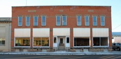 | Waddell Block | building | 2010 | 10000049 |
Every wildfire the federal occurrence database records inside this county: 216 of them, burning about 23,962 acres. 95 started naturally and 2 were recorded as arson. Each settlement page carries the fires within five miles of it.
| Reported cause | Fires |
|---|---|
| Natural | 95 |
| Equipment and vehicle use | 57 |
| Missing data/not specified/undetermined | 32 |
| Debris and open burning | 14 |
| Smoking | 4 |
| Misuse of fire by a minor | 4 |
| Fireworks | 3 |
| Arson/incendiarism | 2 |
| Power generation/transmission/distribution | 2 |
| Other causes | 1 |
| Recreation and ceremony | 1 |
| Railroad operations and maintenance | 1 |
The five largest, by the area the report gives. None of them was recorded as arson.
| Date | Cause | Size | Reported by | Name on the report |
|---|---|---|---|---|
| 24 March 2000 | Debris and open burning | 4,000 acres | Philip Volunteer Fire Department | DON FERGUSON |
| 30 July 2006 | Natural | 3,000 acres | South Dakota Wildland Fire Suppression | not named |
| 19 March 2000 | Missing data/not specified/undetermined | 2,000 acres | Milesville Volunteer Fire Department | DON FERGUSON 2 |
| 19 July 2012 | Missing data/not specified/undetermined | 1,600 acres | South Dakota Wildland Fire Suppression | T-34 FIRE |
| 6 September 2005 | Natural | 1,100 acres | South Dakota Wildland Fire Suppression | DUGAN STEWART - SMITH LANRY |
| 31 August 2005 | Natural | 1,000 acres | South Dakota Wildland Fire Suppression | HANSON - PRICE |
| 12 July 2006 | Natural | 800 acres | South Dakota Wildland Fire Suppression | not named |
| 13 August 2007 | Equipment and vehicle use | 800 acres | South Dakota Wildland Fire Suppression | PRAIRIE BERRY |
Every settlement page carries the fires within five miles of it - see the settlement index below.
The NOAA Storm Events Database holds 570 reports for this county, causing no deaths, no injuries and about $5,534,980 in recorded property damage. Each settlement page carries the reports that name it.
| Kind of event | Reports |
|---|---|
| Thunderstorm Wind | 284 |
| Hail | 222 |
| Tornado | 26 |
| Flood | 23 |
| Flash Flood | 8 |
| Funnel Cloud | 5 |
| Wildfire | 1 |
| Heavy Rain | 1 |
The most serious of them, by death, then injury, then recorded damage. The accounts are quoted exactly as the forecast office filed them.
| When | Event | Place named | Harm | What the report says |
|---|---|---|---|---|
| June 2001 | Thunderstorm Wind | Philip | $3,000,000 | no account filed |
| June 2008 | Flood | Midland | $1,000,000 | Flooding occurred in Philip and throughout much of Haakon County. |
| July 2013 | Thunderstorm Wind | Philip | $500,000 | The combination of large hail and wind caused extensive damage to buildings and vehicles around town. |
| June 1992 | Tornado (F2) | not stated | $250,000 | no account filed |
| May 2019 | Flood | Milesville | $100,000 | Releases from Angostura Dam, combined with runoff from heavy rain, continued to cause major flooding along the Cheyenne River. The Cheyenne River near Plainview reached a preliminary height of 22.87 feet and a peak flow of 61,900 cfs on May 23, which is a new record height and the second highest discharge ever recorded at the location. |
| July 2013 | Hail | Philip | $100,000 | Large hail and strong wind damaged a house, vehicles, tractors, and a baler. |
| July 2003 | Thunderstorm Wind | Philip | $100,000 | Strong winds destroyed a Quonset barn and blew a trailer off its blocks. Several large round hay bales were blown over a fence. |
| July 2004 | Thunderstorm Wind | Philip | $50,000 | Part of barn roof was torn off. |
| July 2004 | Thunderstorm Wind | Billsburg | $50,000 | Winds tore the roof off a 40x60 ft pole barn, damaged a shop building, and blew over road signs. |
| July 2001 | Thunderstorm Wind | Kirley | $50,000 | An old barn and fences were blown down. |
| July 1994 | Hail | not stated | $50,000 | Hail broke windows and damaged vehicles, and 3 inches of rain flooded crops. |
| July 1994 | Tornado (F1) | Philip | $50,000 | The tornado destroyed a pole barn, damaged some old sheds, farm equipment, and several vehicles; and cut a swath through a wheat field. |
| July 2006 | Thunderstorm Wind | Milesville | $25,000 | Mobile home was blown over. |
| July 1964 | Tornado (F2) | not stated | $25,000 | no account filed |
| August 1959 | Tornado (F2) | not stated | $25,000 | no account filed |
| August 2009 | Thunderstorm Wind | Philip | $20,000 | The combination of wind and hail damaged a house, automobiles, and other property. |
| June 2004 | Thunderstorm Wind | Milesville | $20,000 | no account filed |
| August 2009 | Hail | Midland | $15,000 | Large hail damaged and broke windows of automobiles. |
| August 2011 | Hail | Milesville | $15,000 | no account filed |
| June 2012 | Thunderstorm Wind | Philip | $10,000 | Two semi-trailers were blown over a mile north of Philip along Highway 73. A large tree and many branches were blown down in town. |
| July 2011 | Thunderstorm Wind | Philip | $10,000 | Several trees and numerous large branches were downed by the wind in Philip. |
| June 2005 | Thunderstorm Wind | Kirley | $10,000 | Strong winds picked up a large cattle trailer and carried it about 1/8th of a mile, through 3 corral fences and into the middle of the corral. When it went through, it knocked over the corrals, breaking off 12" x 12" square corner posts. Winds also lifted the corner tin off a barn, leaving a hole in the roof. |
| July 2001 | Hail | Grindstone | $10,000 | Large hail broke windows in 3 homes and damaged some crops. |
| August 2011 | Hail | Midland | $10,000 | no account filed |
| August 2011 | Hail | Milesville | $10,000 | no account filed |
| May 2011 | Tornado (EF1) | Philip | $5,000 | A tornado caused minor damage to a ranch north of Philip. Plywood and metal roofing was torn off the house. A metal shed had a collapsed wall and some roof panels torn off. A large grain bin was dented by flying debris. |
| May 2011 | Tornado (EF0) | (Php)Philip Arpt | $5,000 | A small tornado briefly touched down near Ottumwa but caused no damage. |
| May 1993 | Thunderstorm Wind | not stated | $5,000 | Strong thunderstorm winds destroyed a shed in the Philip/Cottonwood area. Heavy rains of three inches or more north of Philip caused dams to run over and a few dams in the Milesville area to be lost. The rains also caused some damage to roads in the area. |
| July 2004 | Thunderstorm Wind | Billsburg | $3,000 | Siding torn off a building and several hay bales were destroyed. |
| May 1974 | Tornado (F2) | not stated | $2,500 | no account filed |
| May 1974 | Tornado (F1) | not stated | $2,500 | no account filed |
| May 1974 | Tornado (F1) | not stated | $2,500 | no account filed |
| March 1961 | Tornado (F1) | not stated | $2,500 | no account filed |
| July 2016 | Thunderstorm Wind | Midland | $1,000 | Strong winds blew the roof off an outbuilding. |
| June 1997 | Hail | Philip | $500 | no account filed |
| May 1974 | Tornado (F1) | not stated | $250 | no account filed |
| August 2016 | Thunderstorm Wind | Philip | $200 | The strong winds ripped a door off a house. |
| June 1952 | Tornado (F0) | not stated | $30 | no account filed |
| June 2025 | Thunderstorm Wind | Midland | - | SD mesonet recorded wind gust. |
| June 2025 | Thunderstorm Wind | Midland | - | SD mesonet recorded wind gust. |
| June 2025 | Thunderstorm Wind | Midland | - | SD mesonet recorded wind gust. |
| July 2025 | Hail | Milesville | - | Larger pieces up to 1 inch in diameter. |
| July 2025 | Thunderstorm Wind | Midland | - | SD Mesonet recorded wind gust. |
| July 2025 | Thunderstorm Wind | (Php)Philip Arpt | - | ASOS recorded wind gust. |
| July 2025 | Thunderstorm Wind | Midland | - | SD Mesonet recorded wind gust. |
| July 2025 | Thunderstorm Wind | Midland | - | SD Mesonet recorded wind gust. |
| July 2025 | Thunderstorm Wind | Midland | - | SD Mesonet recorded wind gust. |
| July 2025 | Thunderstorm Wind | Midland | - | SD Mesonet recorded wind gust. |
| July 2025 | Thunderstorm Wind | Midland | - | SD Mesonet recorded wind gust. |
| July 2025 | Thunderstorm Wind | Midland | - | SD Mesonet recorded wind gust. |
| July 2025 | Thunderstorm Wind | Midland | - | SD Mesonet recorded wind gust. |
| July 2025 | Thunderstorm Wind | Milesville | - | SD Mesonet recorded wind gust. |
| July 2025 | Thunderstorm Wind | Midland | - | SD Mesonet recorded wind gust. |
| September 2025 | Thunderstorm Wind | Milesville | - | SD Mesonet Station recorded the wind gust. |
| September 2025 | Thunderstorm Wind | Milesville | - | SD Mesonet Station recorded the wind gust. |
| August 2025 | Thunderstorm Wind | (Php)Philip Arpt | - | ASOS measured wind gust. |
| August 2025 | Thunderstorm Wind | Midland | - | SD Mesonet recorded wind gust. |
| August 2025 | Thunderstorm Wind | Midland | - | SD Mesonet recorded wind gust. |
| August 2025 | Thunderstorm Wind | Midland | - | SD Mesonet recorded wind gust. |
| August 2024 | Thunderstorm Wind | Milesville | - | Wind gusts were estimated at around 60 mph. |
The Survey's mineral resources record lists 3 workings inside this county. None of them still produces: all are closed or unrecorded. Each settlement page carries the workings within five miles of it.
| Commodity | Workings |
|---|---|
| Sand and Gravel, Construction | 3 |
The least common of them first, because a county's hundredth gravel pit says nothing its first ten did not.
| Where | Site | Commodity | Status | Recorded |
|---|---|---|---|---|
| Kusieh Pit | Sand and Gravel, Construction | Past Producer | ||
| Michael Pit | Sand and Gravel, Construction | Past Producer | ||
| Millage Pit | Sand and Gravel, Construction | Past Producer |
Named settlements recorded in the Geographic Names Information System, each with the topographic sheets covering it. Villages, hamlets and abandoned places alike. Each is shown with the nearest named watercourse or landform and the survey quadrangle it falls on.
West Haakon unorganized territory · 57567 · Post Ranch quadrangle
6 sheets, 1954 to 1984
No longer a settlement
West Haakon unorganized territory · 57567 · Elevenmile Corner quadrangle
6 sheets, 1954 to 1984
East Haakon unorganized territory · 57552 · Near Hay Draw · Nowlin quadrangle
6 sheets, 1954 to 1984
West Haakon unorganized territory · 57567 · On White Willow Creek · Powell quadrangle
6 sheets, 1954 to 1984
West Haakon unorganized territory · 57553 · On Shanty Creek · Murray Draw quadrangle
5 sheets, 1954 to 1984
The vanished settlements of Haakon County: the places named above that are no longer on the map.