 Block
From the record
2 National Register listings published here.
Sources: the National Register database, National Park Service
18 topographic sheets cover 10 settlements here, and 2 properties are on the National Register of Historic Places.
2 National Register listings published here.
Sources: the National Register database, National Park Service
Every property in this county listed on the National Register of Historic Places, with the year it was listed and the federal nomination document.
| Photograph | Property | Type | Listed | Reference |
|---|---|---|---|---|
| Amos Hoffman House | building | 1986 | 86001476 | |
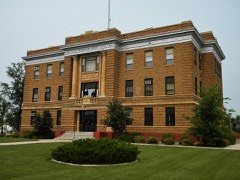 | McPherson County Courthouse | building | 1986 | 86003020 |
Every wildfire the federal occurrence database records inside this county: 204 of them, burning about 10,354 acres. 40 started naturally and none was recorded as arson. Each settlement page carries the fires within five miles of it.
| Reported cause | Fires |
|---|---|
| Equipment and vehicle use | 67 |
| Debris and open burning | 55 |
| Natural | 40 |
| Missing data/not specified/undetermined | 32 |
| Other causes | 3 |
| Smoking | 2 |
| Fireworks | 2 |
| Recreation and ceremony | 1 |
| Railroad operations and maintenance | 1 |
| Misuse of fire by a minor | 1 |
The five largest, by the area the report gives. None of them was recorded as arson.
| Date | Cause | Size | Reported by | Name on the report |
|---|---|---|---|---|
| 23 August 2003 | Missing data/not specified/undetermined | 2,700 acres | South Dakota Wildland Fire Suppression | JOEL BERTSCH 2 |
| 24 March 2004 | Debris and open burning | 1,200 acres | South Dakota Wildland Fire Suppression | ALLEN STUECKLE |
| 3 April 2008 | Equipment and vehicle use | 1,000 acres | South Dakota Wildland Fire Suppression | not named |
| 5 October 2011 | Equipment and vehicle use | 1,000 acres | South Dakota Wildland Fire Suppression | GRASSLAND COLONY |
| 14 May 2009 | Debris and open burning | 300 acres | South Dakota Wildland Fire Suppression | not named |
| 13 April 2006 | Debris and open burning | 300 acres | South Dakota Wildland Fire Suppression | not named |
| 11 July 2006 | Equipment and vehicle use | 250 acres | South Dakota Wildland Fire Suppression | not named |
| 10 April 2015 | Debris and open burning | 200 acres | South Dakota Wildland Fire Suppression | GRASS FIRE |
Every settlement page carries the fires within five miles of it - see the settlement index below.
The NOAA Storm Events Database holds 386 reports for this county, causing 2 deaths, 5 injuries and about $3,493,360 in recorded property damage. Each settlement page carries the reports that name it.
| Kind of event | Reports |
|---|---|
| Hail | 196 |
| Thunderstorm Wind | 135 |
| Tornado | 27 |
| Flood | 10 |
| Flash Flood | 7 |
| Funnel Cloud | 7 |
| Lightning | 2 |
| Wildfire | 1 |
| Heavy Rain | 1 |
The most serious of them, by death, then injury, then recorded damage. The accounts are quoted exactly as the forecast office filed them.
| When | Event | Place named | Harm | What the report says |
|---|---|---|---|---|
| July 1966 | Tornado (F3) | not stated | 2 killed, 4 hurt, $250,000 | no account filed |
| August 2006 | Tornado (F3) | Eureka | 1 hurt | A supercell thunderstorm produced an F3 tornado in southwest Mcpherson county. The tornado was on the ground for nearly a half hour and covered about 14 miles. The tornado touched down near the Campbell county line. There were four different sites damaged with the greatest damage 8 miles south of Eureka and 2 miles southeast of Hillsview. Damage included numerous power poles snapped off, trees shredded of leaves, bark and/or uprooted. Numerous livestock and deer were killed. Devastating damage was observed to farm equipment, homes, barns, grain bins, and vehicles. A well anchored mobile home was completely destroyed. Debris from each site was observed up to 3 miles away. One person received minor scrapes and bruises. |
| June 1979 | Tornado (F1) | not stated | $2,500,000 | no account filed |
| July 1977 | Tornado | not stated | $250,000 | no account filed |
| June 1961 | Tornado (F2) | not stated | $250,000 | no account filed |
| April 2019 | Flood | Greenway | $67,800 | no account filed |
| May 2018 | Flash Flood | Long Lake | $54,000 | no account filed |
| August 2008 | Flash Flood | Spring Creek Colony | $40,000 | Heavy rain caused flash flooding of a farm and surrounding crops and roads 10 miles north northeast of Leola. Water flowed into the basement of the home and severely damaged or destroyed the basement and everything in it. |
| August 1963 | Tornado (F1) | not stated | $25,000 | no account filed |
| July 1962 | Tornado (F2) | not stated | $25,000 | no account filed |
| September 1961 | Tornado (F2) | not stated | $25,000 | no account filed |
| July 1994 | Thunderstorm Wind | Leola | $5,000 | Thunderstorm Winds uprooted some trees. |
| August 2020 | Lightning | Eureka | $1,000 | Lightning struck the roof of a garage, putting a large hole in it. There was smoke, but no fire. |
| August 1993 | Hail | Leola | $500 | no account filed |
| September 1991 | Tornado (F1) | not stated | $30 | no account filed |
| July 1966 | Tornado (F1) | not stated | $30 | no account filed |
| April 2026 | Thunderstorm Wind | Eureka Muni Arpt | - | A trained spotter reported power poles snapped due to thunderstorm wind gusts 6 miles north northeast of Eureka. 615 customers lost power with this system in McPherson county. |
| July 2025 | Thunderstorm Wind | Eureka | - | A trained spotter estimated winds topped out at 50 to 60 mph. |
| August 2025 | Tornado (EFU) | Leola | - | The Leola fire department observed a brief touchdown in an open field. No damage was observed. |
| August 2025 | Thunderstorm Wind | Long Lake | - | A trained spotter 5 miles west of Long Lake estimated thunderstorm winds at 50 to 60 mph. |
| August 2025 | Hail | Langlake | - | Quarter sized hail accompanied thunderstorm winds resulting in crop and garden produce damage. |
| May 2024 | Funnel Cloud | Leola | - | The public relayed through Facebook the presence of a funnel cloud near the town of Leola. |
| May 2024 | Thunderstorm Wind | Eureka | - | A member of the public reported that thunderstorm wind gusts had torn shingled off of a roof. |
| May 2024 | Thunderstorm Wind | Hillsview | - | The public relayed through Facebook that they estimated the thunderstorm wind gusts at around 60 mph. |
| June 2024 | Thunderstorm Wind | Hillsview | - | A member of the public estimates thunderstorm winds reached approximately 60 mph. |
| August 2023 | Hail | Hillsview | - | Hail to the size of quarters combined with wind gusts of 50 to 60 mph resulted in significant crop damage 2 mines north northeast of Hillsview. |
| August 2023 | Thunderstorm Wind | Long Lake Colony | - | School playground equipment damaged. |
| August 2023 | Thunderstorm Wind | Wetonka | - | Paint damage to side of house by wind blown hail. Hail size is unknown. |
| August 2023 | Thunderstorm Wind | Wetonka | - | Thunderstorm winds were strong enough to blow the property off of this individuals patio. |
| June 2022 | Thunderstorm Wind | Hillsview | - | The report was relayed via social media. |
| July 2022 | Heavy Rain | Hillsview | - | The public reported an estimated rainfall amount of 6 inches. |
| June 2022 | Thunderstorm Wind | Leola | - | The wind gust was measured by a personal weather station. |
| June 2022 | Hail | Leola | - | The report of severe hail came from mPING. |
| June 2022 | Thunderstorm Wind | Wetonka | - | Large trees and power polls were downed by significant straight-line wind, and grain bins were severely damaged. The time of the wind was estimated by radar. |
| June 2022 | Thunderstorm Wind | Leola | - | A personal weather station recorded a wind gust of 79 mph. |
| June 2022 | Thunderstorm Wind | Leola | - | A machine shed was destroyed, a stave silo partially destroyed, farm equipment was displaced, machine shed doors pushed in, multiple grain bins dented and widespread tree damage occurred. |
| June 2022 | Thunderstorm Wind | Leola | - | Wind blew in a shop/shed door and blew off the shop/shed's tin roof. It also blew a grain bin off its base, and snapped a pole in half. |
| July 2021 | Thunderstorm Wind | Long Lake | - | A roof was peeled off of a building by estimated 70 mph winds. |
| August 2021 | Thunderstorm Wind | Langlake | - | Sixty mph winds were estimated. |
| June 2021 | Thunderstorm Wind | Hillsview | - | Estimated 70 mph winds took all or part of the roofs off of several sheds along with tipping over a grain bin auger. |
| June 2021 | Thunderstorm Wind | Leola | - | Estimated 80 mph winds caused damage along the south side of Leola including an unroofed barn, tipped grain bins, downed tree branches, tipped camper, and destroyed pole barn. Debris was sent flying into the home of a local resident with no injuries reported. |
| June 2021 | Thunderstorm Wind | Spring Creek Colony | - | A wind power company measured a 90 mph wind gust. |
| July 2020 | Thunderstorm Wind | Spring Creek Colony | - | Seventy mph winds were estimated. |
| July 2020 | Thunderstorm Wind | Wetonka | - | Multiple rounds of severe winds occurred at the residence. There were very strong winds from the northwest along with south winds from the storm inflow. The most significant damage was done to a machine shop which lost the majority of the roof and walls. Farm machinery was damaged including a seed drill which was rotated and a feed wagon which was rolled onto its side. An old barn was toppled. This damage primarily spread from northwest to southeast. Finally, a small outbuilding was tossed back to the north, likely from the strong southerly inflow winds. |
| July 2020 | Thunderstorm Wind | Long Lake Colony | - | Significant damage occurred to the Long Lake Hutterite Colony. Witnesses said two rounds of wind caused damage to the property. Southerly storm inflow winds ripped multiple roof panels off four separate turkey barns. Debris was spread to the west northwest. Additional damage was done to a feed mill and a machine shed was completely destroyed. Debris from these buildings was tossed from north northwest to south southeast. Other grain bin damage also occurred. The total path length was about a half mile or slightly more. |
| July 2020 | Flash Flood | Spring Creek Colony | - | Many county roads were underwater in northeast Mcpherson county due to flash flooding from very heavy rainfall. |
| July 2020 | Thunderstorm Wind | Leola | - | Estimated eighty mph wind downed a tree and collapsed a garage. |
| July 2020 | Thunderstorm Wind | Wetonka | - | Estimated ninety mph winds brought several power poles down, trees and branches down, took part of a shop roof off, along with hay bales blown into different pastures. |
| July 2020 | Thunderstorm Wind | Wetonka | - | Tree and building damage from estimated eighty mph winds. |
| July 2020 | Thunderstorm Wind | Long Lake Colony | - | Estimated ninety mph winds removed panels from a turkey barn roof and damaged a feed mill. A fire truck was completely destroyed. |
| July 2020 | Thunderstorm Wind | Wetonka | - | Estimated ninety mph winds destroyed a machine shed, an old barn, along with other outbuildings. |
| July 2020 | Thunderstorm Wind | Wetonka | - | Estimated ninety mph winds tore the roof off a trailer home and uprooted trees. |
| July 2020 | Thunderstorm Wind | Wetonka | - | Significant damage was done to a machine shed by estimated eighty mph winds. |
| July 2020 | Tornado (EF2) | Wetonka | - | A tornado touched down 3 miles north northwest of Wetonka causing significant damage to the Grassland Hutterite Colony. A large machine shop lost the roof and wall. A large, empty, anchored grain bin was completely removed from its base and the adjacent feed mill was significantly damaged. A 400 foot by 80 foot turkey barn was completely destroyed along with a smaller outbuilding. Debris from these two buildings was scattered in many directions. A trailer was flipped, freight storage unit rotated and two other outbuildings had complete loss of roof panels. Roof and siding damage occurred to many of the residential buildings. Tree and crop damage had also occurred. The tornado tracked over 2 miles southeast, crossing Mcpherson County Highway 23 and ending about one mile north northeast of Wetonka. Debris from the Grassland Colony was dispersed along the entire track of the tornado. |
| August 2020 | Thunderstorm Wind | Eureka | - | Estimated seventy-five mph winds blew the roof off a wood frame quonset with additional roof damage on a second outbuilding. |
| March 2019 | Flood | Greenway | - | Snowmelt flooded several roads in Mcpherson county with some buildings threatened or flooded. On March 30th, County Road 23 two miles south of Highway 10 went underwater and was closed. |
| July 2018 | Thunderstorm Wind | Long Lake | - | Estimated ninety mph winds took a third of the roof off a machine shed and damaged a grain bin. |
| May 2018 | Hail | Eureka Muni Arpt | - | Nickel hail piled up to three inches deep in places. |
| July 2018 | Thunderstorm Wind | Wetonka | - | Sixty mph winds were estimated. |
| July 2018 | Thunderstorm Wind | Madra | - | Estimated ninety mph winds toppled several trees, downed a power line, and moved a semi. |
The Survey's mineral resources record lists 3 workings inside this county. 2 still produce and 1 is closed or unrecorded. Each settlement page carries the workings within five miles of it.
| Commodity | Workings |
|---|---|
| Sand and Gravel, Construction | 3 |
The least common of them first, because a county's hundredth gravel pit says nothing its first ten did not.
| Where | Site | Commodity | Status | Recorded |
|---|---|---|---|---|
| Glaesman Pit & Mill | Sand and Gravel, Construction | Producer | ||
| Obenauer Sand and Gravel | Sand and Gravel, Construction | Producer | ||
| Schnabal Pit | Sand and Gravel, Construction | Past Producer |
Named settlements recorded in the Geographic Names Information System, each with the topographic sheets covering it. Villages, hamlets and abandoned places alike. Each is shown with the nearest named watercourse or landform and the survey quadrangle it falls on.
Central McPherson unorganized territory · 57481 · Wetonka North quadrangle
8 sheets, 1899 to 1985
Central McPherson unorganized territory · 57481 · Wetonka South quadrangle
8 sheets, 1899 to 1985
Central McPherson unorganized territory · 58439 · Forbes NW quadrangle
8 sheets, 1899 to 1985