 Block
From the record
15 National Register listings published here.
Sources: the National Register database, National Park Service
22 topographic sheets cover 8 settlements here, and 15 properties are on the National Register of Historic Places.
15 National Register listings published here.
Sources: the National Register database, National Park Service
Every property in this county listed on the National Register of Historic Places, with the year it was listed and the federal nomination document.
| Photograph | Property | Type | Listed | Reference |
|---|---|---|---|---|
 | Crystal Theatre | building | 2000 | 00001214 |
| Frank and Sarah Drake Claim House | building | 2015 | 14001184 | |
| Egan Park | site | 2003 | 03000556 | |
 | George Few House | building | 1983 | 83003017 |
| First Presbyterian Church and Cemetery | building | 2017 | 100001402 | |
| First Scandinavian Baptist Church | building | 2000 | 00000999 | |
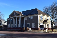 | Flandreau Masonic Temple | building | 1989 | 89001725 |
 | Japanese Gardens Dance Pavilion | building | 1994 | 94001390 |
| Little Village Farm Sale Barn | building | 1995 | 95001469 | |
 | Moody County Courthouse | building | 1993 | 92001863 |
| Pettigrew Barns | building | 2004 | 04000473 | |
| South Dakota Department of Transportation Bridge No. 51-051-000 | structure | 2000 | 99001699 | |
| South Dakota Department of Transportation Bridge No. 51-102-010 | structure | 2000 | 99001693 | |
 | South Dakota Dept. of Trans. Br. No. 51-124-136 | structure | 2001 | 01000090 |
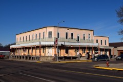 | St. Vincent's Hotel | building | 1983 | 83003018 |
Every wildfire the federal occurrence database records inside this county: 198 of them, burning about 2,203 acres. 3 started naturally and 4 were recorded as arson. Each settlement page carries the fires within five miles of it.
| Reported cause | Fires |
|---|---|
| Missing data/not specified/undetermined | 81 |
| Debris and open burning | 60 |
| Equipment and vehicle use | 23 |
| Smoking | 13 |
| Fireworks | 4 |
| Arson/incendiarism | 4 |
| Misuse of fire by a minor | 3 |
| Natural | 3 |
| Railroad operations and maintenance | 2 |
| Other causes | 2 |
| Power generation/transmission/distribution | 2 |
| Recreation and ceremony | 1 |
The five largest, by the area the report gives. None of them was recorded as arson.
| Date | Cause | Size | Reported by | Name on the report |
|---|---|---|---|---|
| 21 October 2014 | Missing data/not specified/undetermined | 300 acres | South Dakota Wildland Fire Suppression | CAP |
| 6 October 2011 | Missing data/not specified/undetermined | 160 acres | South Dakota Wildland Fire Suppression | VANDYKE BEANFEILD |
| 31 March 2000 | Equipment and vehicle use | 150 acres | Colman Volunteer Fire Department | MALVY CHRISTENSON |
| 8 April 2005 | Debris and open burning | 120 acres | South Dakota Wildland Fire Suppression | LEBRUN |
| 15 April 2009 | Debris and open burning | 100 acres | South Dakota Wildland Fire Suppression | not named |
| 15 October 2014 | Missing data/not specified/undetermined | 95 acres | South Dakota Wildland Fire Suppression | SOYBEAN FIRE |
| 5 November 2001 | Debris and open burning | 80 acres | Colman Volunteer Fire Department | CARLTON LEWEUS |
| 30 March 2005 | Missing data/not specified/undetermined | 79 acres | South Dakota Wildland Fire Suppression | LAKE |
Every settlement page carries the fires within five miles of it - see the settlement index below.
The NOAA Storm Events Database holds 323 reports for this county, causing no deaths, 1 injury and about $4,695,250 in recorded property damage. Each settlement page carries the reports that name it.
| Kind of event | Reports |
|---|---|
| Hail | 121 |
| Thunderstorm Wind | 96 |
| Flood | 87 |
| Tornado | 10 |
| Lightning | 5 |
| Flash Flood | 4 |
The most serious of them, by death, then injury, then recorded damage. The accounts are quoted exactly as the forecast office filed them.
| When | Event | Place named | Harm | What the report says |
|---|---|---|---|---|
| June 1956 | Tornado (F2) | not stated | 1 hurt, $2,500 | no account filed |
| May 2012 | Thunderstorm Wind | Flandreau | $1,000,000 | Thunderstorm winds caused widespread damage in the south part of Flandreau. Roofs on homes, apartment buildings, and other buildings were blown off or damaged. The roof of a large church was blown off, and parts of the roof damaged nearby homes. The Flandreau city office building had part of its south wall blown off, resulting in interior damage to ceiling tiles and insulation. Siding on other walls of this building and on numerous homes was damaged. Tree damage was widespread, including several trees blown down or uprooted. The winds blew down power lines, leaving parts of the city without power for almost three hours. |
| September 2019 | Flood | Colman | $604,000 | Flooding resulted in some crop loss and extensive damage to public infrastructure including numerous county and township roads, culverts, and some bridges. The property damage costs include estimates for public property losses. Crop loss estimates provided by the United States Department of Agriculture. |
| May 1993 | Tornado (F1) | Colman to | $500,000 | A tornado touched down intermittently on a northeast path through Moody County causing various kinds of damage. South of Colman the tornado hit a farm killing 23 pigs, damaging tractors and equipment, and moving the rafters in a house. At 659 PM CDT the tornado was sighted by spotters one one-half mile southwest of Colman. South of Egan high winds destroyed a garage. At 710 PM CDT a 30,000 lb. semi-truck traveling west on SD highway 34 became temporarily airborne and was thrown into the ditch damaging the truck beyond repair but not hurting the driver. At 725 PM CDT the tornado hit a farm two miles west of Ward shearing off the top of a silo, and damaging the barn and garage. |
| July 2011 | Thunderstorm Wind | Flandreau | $300,000 | Thunderstorm winds caused widespread tree damage in Flandreau, including numerous trees uprooted or snapped. Several homes and vehicles were damaged, mostly by falling trees or tree debris. A large camper in the city park was overturned. The winds and tree debris also damaged power lines, causing a power outage. Tree debris blocked numerous roads in and near town. Damage to the city's electrical system alone was later estimated at $125,000. |
| June 1998 | Thunderstorm Wind | Colman | $300,000 | no account filed |
| March 2019 | Flood | Colman | $260,000 | Flooding resulted in damage to public infrastructure including county and township roads and culverts. |
| September 2019 | Flood | Flandreau | $250,000 | After excessive two-day rainfall during September 10-12 (6.57 inches near Aurora, 6.55 inches 3 miles west southwest of Brookings, 6.27 inches 8 miles south of Brookings), the Big Sioux River near Brookings (gage site BRKS2) reached the second highest stage on record of 5.39 feet above flood stage on September 13. Numerous county roads and bridges were inundated, with a few farm outbuildings engulfed in water. Agricultural flooding was extensive. |
| April 2011 | Flood | Colman | $200,000 | Major flooding of the Big Sioux River, as well as flooding of lakes and lowlands in the county, continued through April, though small stream flooding abated and flooding in other areas such as the city of Flandreau abated some. Some farmland remained flooded, both near to and away from the Big Sioux River. A few roads remained closed by the flooding for part of the month. Water was covering some other roads, mainly from flooded lowlands. Some roads were damaged. High water and groundwater levels from record precipitation in the year 2010, a main reason the flooding onset was so fast in March, was also a main reason that the flooding subsided so slowly during April. |
| June 1996 | Hail | Flandreau | $200,000 | no account filed |
| June 2024 | Flood | Colman | $105,000 | Rainfall amounts across Moody County from June 20-22 ranged from 4 to 9 inches. This rainfall resulted in some overland flooding and minor to moderate flooding along the Big Sioux River and Flandreau Creek. ||Overland flooding resulted in some damages to township and county roads. Preliminary damage assessments estimate loss to public infrastructure to be around 105 thousand dollars.||The majority of overland flooding subsided by June 23, bur river flooding continued through the end of the month. For additional information on river flooding, please see other flood entries for Moody County. |
| August 2019 | Thunderstorm Wind | Flandreau Muni Arpt | $100,000 | Thunderstorm outflow caused significant damage to farm outbuildings. |
| September 2019 | Flood | Lone Tree | $100,000 | After excessive two-day rainfall during September 10-12 (6.71 inches 11 miles north of Colman, 8.82 inches at Flandreau), the Big Sioux River at Trent (gage site TRES2) reached the highest stage on record of 6.24 feet above flood stage on September 13. Numerous houses were inundated in Trent, as well as almost all county and township roads in the area near the river. |
| September 2010 | Flood | Flandreau | $100,000 | Widespread heavy rain, combined with saturated ground, caused a fairly rapid rise of the Big Sioux River to moderate to major flooding levels. Roads and numerous agricultural land near the river were flooded. Several homes near the river were flooded, and several people were evacuated. Damage to homes and some roads was reported, although the known damage was thought to be a small part of the total damage. |
| July 2000 | Hail | Flandreau | $100,000 | Large hail damaged crops and trees. The hail also broke windows and dented vehicles. |
| June 2000 | Lightning | Colman | $70,000 | Lightning struck a house, starting a fire which caused heavy damage. |
| September 2019 | Flood | Flandreau | $50,000 | After excessive two-day rainfall during September 10-12 (6.71 inches 11 miles north of Colman, 8.82 inches at Flandreau), the Big Sioux River near Egan (gage site EGAS2) reached the highest stage on record of 7.70 feet above flood stage on September 12. Extensive agricultural flooding occurred around Egan, and water encroached into homes on the east side of Egan. |
| June 2014 | Flood | Colman | $50,000 | Persistent moderate to heavy rain caused flooding of fields and other lowlands, including several roads, homes, and businesses. This flooding lasted for almost two days, and was aggravated locally by additional storms during that time. Some roads were damaged or washed out. |
| July 2011 | Thunderstorm Wind | Sioux Falls Jct | $50,000 | Thunderstorm winds blew over 4 semi-trailer trucks and a camper at the Flandreau exit of Interstate 29. |
| July 1997 | Hail | Trent | $50,000 | no account filed |
| August 2005 | Thunderstorm Wind | Trent | $30,000 | Thunderstorm winds destroyed a barn by moving it 100 feet off its foundation, after which it collapsed. The collapsing barn heavily damaged a stock trailer. The winds also blew off part of the roof of a barn on a nearby farm. Tree damage was significant, with over 20 trees blown down, as well as numerous branches on other trees. One large branch that fell damaged a car and the roof of a house. |
| June 2001 | Thunderstorm Wind | Colman | $30,000 | Thunderstorm winds caused tree damage, and blew electrical poles over to a 45 degree angle. |
| May 1996 | Thunderstorm Wind | Flandreau | $30,000 | no account filed |
| September 2019 | Flood | Flandreau | $25,000 | After excessive two-day rainfall during September 10-12 (6.71 inches 11 miles north of Colman, 8.82 inches at Flandreau), the Big Sioux River above Flandreau (gage site BSFS2) reached the highest stage on record of 5.29 feet above flood stage on September 13. Water inundated Flandreau Park as well as numerous county and township roads north of Flandreau. |
| September 2019 | Flood | Flandreau | $25,000 | After excessive two-day rainfall during September 10-12 (8.93 inches at Flandreau and 8.64 inches near Pipestone), Flandreau Creek near Flandreau (gage site FCRS2) reached the highest stage on record of 5.46 feet above flood stage on September 12. 487th Avenue at the gage site and numerous other township roads were inundated by water, as well as the Flandreau Golf Club. Significant amounts of agricultural land were also flooded. |
| September 2017 | Thunderstorm Wind | Colman | $25,000 | Farm equipment and a few trees were damages. |
| July 2010 | Hail | Flandreau | $25,000 | Large hail was accompanied by wind gusts up to 40 mph. The hail caused damage to several vehicles, and also caused an unknown amount of crop damage. |
| May 2011 | Lightning | Flandreau | $20,000 | Lightning struck a light pole and damaged a gas line, starting a fire in a house. The fire destroyed a wall and siding. |
| July 2011 | Thunderstorm Wind | Egan | $10,000 | Thunderstorm winds flattened a Morton building. |
| July 2010 | Thunderstorm Wind | Egan | $10,000 | Thunderstorm winds blew the roofs off several storage bins. |
| June 2008 | Tornado (EF1) | Trent | $10,000 | A tornado blew a 40 by 100 foot metal machine shed a quarter mile, destroyed an outbuilding, and damaged trees. |
| May 2004 | Thunderstorm Wind | Colman | $10,000 | Thunderstorm winds caused tree damage and blew down power lines along state highway 34, 2 miles east of Interstate 29. |
| July 2000 | Thunderstorm Wind | Colman | $10,000 | Thunderstorm winds tore the roof off a cattle shed. The winds also caused tree damage, including at least 20 trees blown down. |
| October 2019 | Flood | Flandreau | $5,000 | After rainfall on October 1 of 1.08 inches in Clear Lake, 0.81 inches in Bruce, and 0.80 inches in Brookings, the Big Sioux River near Brookings (gage site BRKS2) climbed back into flood stage and crested at 0.13 feet above flood stage on October 7. A few county and township roads were flooded near the gage site, along with a considerable amount of agricultural land. Property damage costs are rough estimates. |
| September 2019 | Flood | Colman | $5,000 | After excessive two-day rainfall during September 10-12 (record 2-day 8.52 inches 2 miles north of Chester), Skunk Creek near Chester (gage site SCCS2) reached the second highest stage on record of 0.33 feet above flood stage on September 12. Significant amounts of agricultural land were inundated. |
| September 2019 | Flood | Flandreau Muni Arpt | $5,000 | After excessive two-day rainfall during September 10-12 (record 2-day rainfall of 6.75 inches at Pipestone), Pipestone Creek below Pipestone (gage site PSTM5) reached the highest stage on record of 1.74 feet above flood stage on September 12. A water rescue was necessary when a motorist drove into rapidly flowing waters on Minnesota State Highway 30 around 315 am on September 12. In total, 13.5 miles of county maintained roads were under water at one point. Significant flooding of agricultural land occurred. |
| May 2012 | Thunderstorm Wind | Flandreau Muni Arpt | $5,000 | Thunderstorm winds flattened a billboard sign with a metal frame. |
| March 2012 | Thunderstorm Wind | Trent | $5,000 | Thunderstorm winds damaged several outbuildings on a farmstead. |
| June 2002 | Lightning | Flandreau | $5,000 | Lightning struck a house, damaging both exterior and interior walls, and damaging electrical and telephone lines to the house. |
| July 1998 | Lightning | Flandreau | $5,000 | no account filed |
| October 1997 | Thunderstorm Wind | Colman | $5,000 | no account filed |
| August 2021 | Thunderstorm Wind | Trent | $2,000 | Thunderstorm wind gusts downed several large tree limbs from 6 to 10 inches in diameter. Property damage costs are a rough estimate. |
| September 2009 | Lightning | Colman | $1,000 | Lightning started a grass fire which burned over two acres, before being contained by the Brookings Fire Department. |
| May 1983 | Tornado (F0) | not stated | $250 | no account filed |
| May 1983 | Tornado (F0) | not stated | $250 | no account filed |
| May 1983 | Tornado (F0) | not stated | $250 | no account filed |
| June 2025 | Flood | Colman | - | The Big Sioux River near Brookings rose above flood stage the morning of June 30th, cresting around 0.98 feet above flood stage (9.98 feet) on June 30th. The river continued rising into early July. |
| July 2025 | Flood | Colman | - | The Big Sioux River near Brookings continued above flood stage from June, further rising to a crest around 1.39 feet above flood stage (10.39 feet). The river then fell below flood stage during the afternoon of July 9th. |
| August 2025 | Thunderstorm Wind | Sioux Falls Jct | - | A several minute period of severe thunderstorm winds with a peak gust of 61 mph was measured by a Road Weather Information System site 13 miles west of Ward. |
| August 2025 | Thunderstorm Wind | Sioux Falls Jct | - | Thunderstorm wind gusts were measured by a Road Weather Information System sensor 13 miles west of Ward. |
| June 2025 | Thunderstorm Wind | Sioux Falls Jct | - | Thunderstorm wind gusts were measured at the South Dakota RWIS site 13 miles west of Ward. |
| September 2025 | Thunderstorm Wind | Flandreau Muni Arpt | - | Thunderstorm wind gusts broke a 3-inch diameter tree branch. |
| September 2025 | Thunderstorm Wind | Trent | - | Thunderstorm wind gusts as high as 73 mph were measured by a personal weather station near Trent. |
| July 2024 | Flood | Flandreau | - | Flooding continued from June on the Big Sioux River near Brookings, with declining river levels. The river fell below flood stage on the evening of July 2nd. |
| July 2024 | Thunderstorm Wind | Flandreau | - | Medium branches up to 3 to 4 inches in diameter were downed by thunderstorm wind gusts. |
| June 2024 | Flood | Lone Tree | - | The Big Sioux River at Trent rose above flood stage the morning of June 22nd, cresting around 2.33 feet above flood stage (1497.33 feet) on June 24th. This crest is in the Moderate Stage. The river then fell below flood stage on the morning of June 30th. For a more comprehensive description of flood damage, please see other entries for Moody County. |
| June 2024 | Flood | Flandreau Muni Arpt | - | Pipestone Creek below Pipestone rose above flood stage the morning of June 21st, cresting around 0.92 feet above flood stage (1595.92 feet) on June 22nd. The creek then fell below flood stage on the morning of June 24th. For a more comprehensive description of flood damage, please see other entries for Moody County. |
| June 2024 | Flood | Flandreau | - | The Big Sioux River near Flandreau rose above flood stage the evening of June 22nd, cresting around 0.03 feet above flood stage (1540.03 feet) on June 22nd. The river then fell below flood stage on the morning of June 23rd. For a more comprehensive description of flood damage, please see other entries for Moody County. |
| June 2024 | Flood | Flandreau | - | The Big Sioux River near Egan rose above flood stage the afternoon of June 22nd, cresting around 2.86 feet above flood stage (1519.36 feet) on June 23rd. This crest is in the Moderate Stage. The river then fell below flood stage on the morning of June 30th. For a more comprehensive description of flood damage, please see other entries for Moody County. |
| June 2024 | Flood | Flandreau | - | Flandreau Creek near Flandreau rose above flood stage the morning of June 22nd, cresting around 2.46 feet above flood stage (11.46 feet) on June 22nd. This crest is in the Moderate Stage. The creek then fell below flood stage on the afternoon of June 24th. For a more comprehensive description of flood damage, please see other entries for Moody County. |
The Survey's mineral resources record lists 18 workings inside this county. 8 still produce and 10 are closed or unrecorded. Each settlement page carries the workings within five miles of it.
| Commodity | Workings |
|---|---|
| Sand and Gravel, Construction | 18 |
The least common of them first, because a county's hundredth gravel pit says nothing its first ten did not.
| Where | Site | Commodity | Status | Recorded |
|---|---|---|---|---|
| Bennett Pit | Sand and Gravel, Construction | Producer | ||
| Flandreau Ready Mix Sand Pit | Sand and Gravel, Construction | Producer | ||
| Gravel Pit | Sand and Gravel, Construction | Unknown | ||
| Gravel Pit | Sand and Gravel, Construction | Producer | ||
| Gravel Pit | Sand and Gravel, Construction | Past Producer | ||
| Gravel Pit | Sand and Gravel, Construction | Unknown | ||
| Gravel Pit | Sand and Gravel, Construction | Producer | ||
| Gravel Pit | Sand and Gravel, Construction | Past Producer | ||
| Gravel Pit | Sand and Gravel, Construction | Unknown | ||
| Gravel Pit | Sand and Gravel, Construction | Past Producer | ||
| Gravel Pit | Sand and Gravel, Construction | Past Producer | ||
| Gravel Pit | Sand and Gravel, Construction | Producer | ||
| Gravel Pits | Sand and Gravel, Construction | Unknown | ||
| Gravel Pits | Sand and Gravel, Construction | Past Producer | ||
| Gravel Pits | Sand and Gravel, Construction | Past Producer | ||
| Johnson Gravel Pit | Sand and Gravel, Construction | Producer | ||
| Larsen Gravel Pit | Sand and Gravel, Construction | Producer | ||
| Rubin Johnson Pit | Sand and Gravel, Construction | Producer |
Named settlements recorded in the Geographic Names Information System, each with the topographic sheets covering it. Villages, hamlets and abandoned places alike. Each is shown with the nearest named watercourse or landform and the survey quadrangle it falls on.
Egan township · 57024 · On Isanti Creek · Trent quadrangle
8 sheets, 1955 to 1985