 Block
From the record
7 National Register listings published here.
Sources: the National Register database, National Park Service
23 topographic sheets cover 6 settlements here, and 7 properties are on the National Register of Historic Places.
7 National Register listings published here.
Sources: the National Register database, National Park Service
Every property in this county listed on the National Register of Historic Places, with the year it was listed and the federal nomination document.
| Photograph | Property | Type | Listed | Reference |
|---|---|---|---|---|
 | D. H. and Leah Curran House | building | 1996 | 96000741 |
| DeRouchey-Hageman Barn and Farmyard | building | 2024 | 100009810 | |
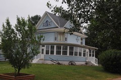 | George Holland House | building | 1989 | 89001721 |
| North Canton School-District No. 12 | building | 1986 | 86001025 | |
 | Potter County Courthouse | building | 1996 | 96000743 |
| St. Bernard's Catholic Church | building | 1980 | 80003731 | |
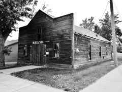 | G. L. Stocker Blacksmith Shop | building | 1996 | 96000744 |
Every wildfire the federal occurrence database records inside this county: 94 of them, burning about 17,023 acres. 22 started naturally and none was recorded as arson. Each settlement page carries the fires within five miles of it.
| Reported cause | Fires |
|---|---|
| Equipment and vehicle use | 32 |
| Natural | 22 |
| Missing data/not specified/undetermined | 20 |
| Debris and open burning | 16 |
| Power generation/transmission/distribution | 3 |
| Fireworks | 1 |
The five largest, by the area the report gives. None of them was recorded as arson.
| Date | Cause | Size | Reported by | Name on the report |
|---|---|---|---|---|
| 2 April 2015 | Equipment and vehicle use | 5,100 acres | South Dakota Wildland Fire Suppression | HWY 212 |
| 1 April 2015 | Equipment and vehicle use | 4,800 acres | South Dakota Wildland Fire Suppression | LEBANON FIRE |
| 26 March 1999 | Missing data/not specified/undetermined | 2,000 acres | Kadoka Volunteer Fire Department | YELLOW BEAR |
| 5 October 2011 | Equipment and vehicle use | 1,200 acres | South Dakota Wildland Fire Suppression | ABLER |
| 24 September 2003 | Power generation/transmission/distribution | 750 acres | South Dakota Wildland Fire Suppression | KULA |
| 10 January 2000 | Debris and open burning | 640 acres | Kennebec Volunteer Fire Department | BOSCHEE |
| 31 July 2001 | Natural | 500 acres | Gettysburg Volunteer Fire Department | DALE ROBINSON |
| 10 July 2002 | Equipment and vehicle use | 400 acres | Gettysburg Volunteer Fire Department | ROBERT HOUCK |
Every settlement page carries the fires within five miles of it - see the settlement index below.
The NOAA Storm Events Database holds 309 reports for this county, causing no deaths, no injuries and about $2,915,750 in recorded property damage. Each settlement page carries the reports that name it.
| Kind of event | Reports |
|---|---|
| Hail | 134 |
| Thunderstorm Wind | 133 |
| Tornado | 20 |
| Flash Flood | 9 |
| Flood | 8 |
| Funnel Cloud | 4 |
| Lightning | 1 |
The most serious of them, by death, then injury, then recorded damage. The accounts are quoted exactly as the forecast office filed them.
| When | Event | Place named | Harm | What the report says |
|---|---|---|---|---|
| June 1979 | Tornado (F1) | not stated | $2,500,000 | no account filed |
| April 2023 | Flood | Gettysburg | $150,000 | no account filed |
| April 2019 | Flood | Gettysburg | $109,500 | no account filed |
| May 1995 | Tornado (F0) | Gettysburg | $25,000 | Grain bin and a livestock trailer were destroyed by a narrow path tornado. |
| August 1981 | Tornado (F1) | not stated | $25,000 | no account filed |
| August 1981 | Tornado (F1) | not stated | $25,000 | no account filed |
| July 1965 | Tornado (F1) | not stated | $25,000 | no account filed |
| June 1964 | Tornado (F2) | not stated | $25,000 | no account filed |
| September 1999 | Flash Flood | Gettysburg | $14,000 | no account filed |
| June 1995 | Hail | Gettysburg | $5,000 | Large hail destroyed six wquare miles of winter wheat and corn in northwest Potter County. On a farm in northwest Potter County, many house and farm building windows were broken. The windshields on two vehicles were also shattered from the large hail. |
| July 1994 | Thunderstorm Wind | Hoven | $5,000 | Thunderstorm Winds downed some trees and power lines. |
| April 1955 | Tornado (F2) | not stated | $2,500 | no account filed |
| April 1955 | Tornado (F2) | not stated | $2,500 | no account filed |
| June 1995 | Hail | Gettysburg | $2,000 | Hail accumulated to two inches deep in places with some windows broken. |
| April 1955 | Tornado (F2) | not stated | $250 | no account filed |
| June 2025 | Funnel Cloud | Gorman | - | The Potter county Emergency Manager reports a funnel cloud north of Agar. |
| August 2025 | Hail | Hoven | - | Hail up to three inches in diameter was observed in Hoven. Several other reports of hail between 1.00 and 2.75 inches were received. |
| August 2025 | Thunderstorm Wind | Gorman | - | A peak wind gust of 70 mph was observed at a South Dakota Department of Transportation weather station four miles north of Agar. |
| June 2023 | Thunderstorm Wind | Gorman | - | A South Dakota Department of Transportation weather station recorded a wind gust of 69 mph. |
| June 2023 | Thunderstorm Wind | Gorman | - | A personal weather station recorded a wind gust of 60 mph. |
| June 2023 | Thunderstorm Wind | Gorman | - | A South Dakota Department of Transportation weather station recorded a wind gust of 59 mph. |
| June 2023 | Thunderstorm Wind | Gorman | - | A South Dakota Department of Transportation weather station recorded a wind gust of 64 mph. |
| June 2023 | Thunderstorm Wind | Gettysburg Arpt | - | An Automated Weather Observing System weather station recorded a wind gust of 59 mph. |
| March 2019 | Flood | Gettysburg | - | Flooding of several township and county roads occurred. |
| August 2019 | Hail | Gorman | - | A severe thunderstorm with large hail and destructive winds left southeast Dewey crossing the Missouri River into western Potter county continuing to destroy crop and grassland in its path. The storm continued to move southeast entering northern Sully county. |
| August 2019 | Thunderstorm Wind | Gorman | - | Eighty mph winds along with tennis ball size hail shredded siding, broke many windows, along with downing many trees. Hail piled up to 7 to 8 inches deep in places. |
| July 2019 | Thunderstorm Wind | Gettysburg | - | Two grain bins were blown off their bases with two other bins receiving extensive damage. |
| July 2018 | Flash Flood | Gorman | - | Very heavy rains of 3 to 5 inches brought flash flooding to parts of western Potter county where several roads were flooded. |
| August 2016 | Hail | Gorman | - | Quarter size hail caused some crop damage. |
| June 2015 | Thunderstorm Wind | Hoven | - | Sixty mph winds were estimated. |
| June 2015 | Thunderstorm Wind | Tolstoy | - | Winds gusted to nearly eighty mph behind an exiting thunderstorm which did cause structural damage to a few outbuildings. |
| July 2015 | Flash Flood | Tolstoy | - | Heavy rains of over three inches flooded some area fields along with a few roads. |
| July 2015 | Flash Flood | Hoven | - | Heavy rains caused the flash flooding of several roads with the gravel being washed away in places. |
| June 2014 | Thunderstorm Wind | Lebanon | - | Sixty mph winds brought some tree limbs down. |
| July 2013 | Thunderstorm Wind | Gorman | - | An estimated 60 mph wind gust was reported by a trained spotter. |
| July 2013 | Thunderstorm Wind | Gettysburg | - | The sheriff on duty estimated 60 mph winds west of Gettysburg. |
| June 2013 | Thunderstorm Wind | Gettysburg | - | Damaging winds brought trees branches down and knocked power out in Gettysburg. |
| June 2012 | Thunderstorm Wind | Hoven | - | Sixty mph winds downed a few branches in Hoven. |
| July 2011 | Tornado (EF0) | Hoven | - | A tornado touched down briefly in Hoven heavily damaging the roof of a business along with downing several trees. |
| July 2011 | Thunderstorm Wind | Hoven | - | Sixty mph winds were estimated west of Hoven. |
| August 2011 | Hail | Tolstoy | - | Very large hail up to three inches in diameter caused some vehicle and siding damage in Tolstoy. |
| July 2011 | Hail | Hoven | - | Golfball size hail damaged some corn. |
| July 2011 | Hail | Gettysburg | - | Golfball hail damaged corn and wheat crops along with tearing a window screen. |
| June 2011 | Flood | Gettysburg | - | Heavy rain flooded most of the roads in Gettysburg with many basements also receiving water. |
| June 2011 | Flash Flood | Gettysburg | - | Heavy rain created widespread street flooding in the town of Gettysburg. |
| July 2011 | Thunderstorm Wind | Gettysburg | - | Sixty mph winds were estimated near Gettysburg. |
| June 2010 | Thunderstorm Wind | Gettysburg | - | Sixty mph winds were estimated by the public. |
| June 2010 | Thunderstorm Wind | Lebanon | - | Sixty mph winds blew the chicken coop next to the grain bin. |
| May 2010 | Thunderstorm Wind | Gettysburg | - | Sixty mph winds were estimated by the public. |
| June 2009 | Tornado (EF0) | Lebanon | - | A tornado touched down northwest of Lebanon with no damage reported. |
| June 2009 | Tornado (EF0) | Lebanon | - | A tornado touched down briefly northwest of Lebanon with no damage occurring. |
| September 2008 | Thunderstorm Wind | Lebanon | - | Sixty mph winds blew a large barn door off of its track. |
| June 2007 | Funnel Cloud | Hoven | - | Several reports of funnel clouds were received from the public in northwest Potter county. |
| June 2007 | Flash Flood | Gettysburg | - | Heavy rains flooded many streets in Gettysburg along with the entire park. |
| June 2006 | Tornado (F0) | Gettysburg | - | A weak tornado touched down briefly southwest of Gettysburg in an open area causing no damage. |
| August 2006 | Flash Flood | Gettysburg | - | Heavy rains of 4 to 5 inches caused flash flooding in and around Gettysburg with many roads flooded. |
| August 2006 | Flash Flood | Gettysburg | - | Heavy rains caused flash flooding in and around Gettysburg with streets and roads flooded. |
| June 2005 | Thunderstorm Wind | Gettysburg | - | Winds over 90 mph destroyed a hanger at the airport, downed many trees, and damaged many structures in and around Gettysburg. |
| May 2003 | Flash Flood | Hoven | - | Heavy rainfall of 2 to 4 inches flooded many county roads in northeast Potter county. |
| June 2003 | Tornado (F0) | Gettysburg | - | A tornado touched down briefly southwest of Gettysburg causing no damage. |
The Survey's mineral resources record lists 6 workings inside this county. 4 still produce and 2 are closed or unrecorded. Each settlement page carries the workings within five miles of it.
| Commodity | Workings |
|---|---|
| Sand and Gravel, Construction | 6 |
The least common of them first, because a county's hundredth gravel pit says nothing its first ten did not.
| Where | Site | Commodity | Status | Recorded |
|---|---|---|---|---|
| Bill Kaiser Pit | Sand and Gravel, Construction | Producer | ||
| Gravel Pit | Sand and Gravel, Construction | Past Producer | ||
| Gravel Pit | Sand and Gravel, Construction | Producer | ||
| Gravel Pit | Sand and Gravel, Construction | Past Producer | ||
| Hageman Pit | Sand and Gravel, Construction | Producer | ||
| Knott Pit No 2 | Sand and Gravel, Construction | Producer |
Named settlements recorded in the Geographic Names Information System, each with the topographic sheets covering it. Villages, hamlets and abandoned places alike. Each is shown with the nearest named watercourse or landform and the survey quadrangle it falls on.
West Potter unorganized territory · 57442 · Patch Skin Buttes SE quadrangle
7 sheets, 1953 to 1985