 Block
From the record
8 National Register listings published here, 2 of them National Historic Landmarks.
Sources: the National Register database, National Park Service
27 topographic sheets cover 10 settlements here, and 8 properties are on the National Register of Historic Places.
8 National Register listings published here, 2 of them National Historic Landmarks.
Sources: the National Register database, National Park Service
Every property in this county listed on the National Register of Historic Places, with the year it was listed and the federal nomination document.
| Photograph | Property | Type | Listed | Reference |
|---|---|---|---|---|
 | American Legion Community Hall | building | 2017 | 100001403 |
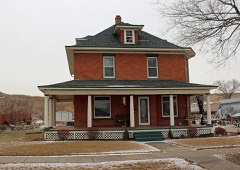 | Jefferson Davis Carr House | building | 1982 | 82003942 |
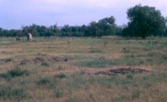 | Fort Pierre Chouteau Site | site | 1976 | 76001756 |
 | La Verendrye Site | site | 1974 | 74001899 |
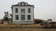 | Old Fort Pierre School | building | 1977 | 77001255 |
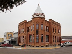 | Stockgrowers Bank Building | building | 1977 | 77001256 |
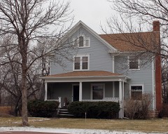 | Gaylord Sumner House | building | 1977 | 77001257 |
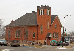 | United Church of Christ, Congregational | building | 1977 | 77001258 |
Every wildfire the federal occurrence database records inside this county: 172 of them, burning about 68,987 acres. 50 started naturally and 4 were recorded as arson. Each settlement page carries the fires within five miles of it.
| Reported cause | Fires |
|---|---|
| Equipment and vehicle use | 51 |
| Natural | 50 |
| Missing data/not specified/undetermined | 31 |
| Debris and open burning | 13 |
| Fireworks | 11 |
| Recreation and ceremony | 5 |
| Arson/incendiarism | 4 |
| Misuse of fire by a minor | 2 |
| Other causes | 2 |
| Smoking | 2 |
| Power generation/transmission/distribution | 1 |
The five largest, by the area the report gives. None of them was recorded as arson.
| Date | Cause | Size | Reported by | Name on the report |
|---|---|---|---|---|
| 17 September 2000 | Natural | 35,000 acres | Agar Volunteer Fire Department | HOUCK RANCH |
| 17 September 2000 | Natural | 25,000 acres | South Dakota Wildland Fire Suppression | HAYES |
| 16 July 2006 | Natural | 2,185 acres | Lower Brule Agency | THOMPSON COMPLEX |
| 16 July 2006 | Natural | 1,800 acres | South Dakota Wildland Fire Suppression | FT. PIERRE CPX |
| 23 August 2020 | Natural | 561 acres | South Dakota Wildland Fire Suppression | LUCKY STRIKE CA |
| 12 August 2006 | Natural | 500 acres | South Dakota Wildland Fire Suppression | not named |
| 16 April 1994 | Equipment and vehicle use | 400 acres | Nebraska National Forest | FT. PIERRE RIDINGS |
| 12 August 2006 | Natural | 400 acres | South Dakota Wildland Fire Suppression | not named |
Every settlement page carries the fires within five miles of it - see the settlement index below.
The NOAA Storm Events Database holds 429 reports for this county, causing no deaths, 11 injuries and about $5,178,060 in recorded property damage. Each settlement page carries the reports that name it.
| Kind of event | Reports |
|---|---|
| Thunderstorm Wind | 199 |
| Hail | 183 |
| Tornado | 22 |
| Flood | 15 |
| Flash Flood | 9 |
| Wildfire | 1 |
The most serious of them, by death, then injury, then recorded damage. The accounts are quoted exactly as the forecast office filed them.
| When | Event | Place named | Harm | What the report says |
|---|---|---|---|---|
| August 1969 | Tornado (F1) | not stated | 3 hurt, $25,000 | no account filed |
| July 1986 | Thunderstorm Wind | not stated | 3 hurt | no account filed |
| July 1987 | Thunderstorm Wind | not stated | 2 hurt | no account filed |
| July 1995 | Thunderstorm Wind | Pierre | 1 hurt, $40,000 | Eighty mph winds destroyed two mobile homes parked in the Chantier Heights Development 15 miles northwest of Pierre on South Dakota Highway 1806. A 77-year-old woman was injured when her mobile home parked on a bluff overlooking Lake Oahe partially rolled down the bluff, toward the lake. The woman received, minor injuries. |
| August 1960 | Tornado (F2) | not stated | 1 hurt, $25,000 | no account filed |
| June 2015 | Thunderstorm Wind | Hayes | 1 hurt | Measured winds of over one-hundred twenty mph by a home wind system rolled a camper office building and destroyed several grain bins. One person was injured when the office building rolled. |
| July 1994 | Thunderstorm Wind | Onida to Pierre | $5,000,000 | Widespread wind damage included cars piled into buildings at Fort Pierre, highway signs torn off, billboards uprooted, a hole in the roof of Pierre City Hall from falling tree branches, numerous downed power lines and poles, a roof blown off a business in Onida, roofs on many dwellings damaged, many trees blown down including some large ones, many broken tree branches and limbs littering and blocking roads, trees stripped of leaves, crops damaged or destroyed over large areas, and several small farm buildings destroyed. Heavy rain of 2 to 6 inches in the Pierre and Forth Pierre areas flooded roads and basements and added to the crop damage. |
| June 2008 | Flash Flood | Wendte | $30,000 | Very heavy rains of 2 to 4 inches fell across much of Stanley county causing extensive flash flooding. Many dams were broken along with tens of fences crossing creeks in the county. Seventeen roads also sustained some form of damage from the flooding. |
| July 1995 | Thunderstorm Wind | Pierre | $30,000 | Eighty mph winds were responsible for damaging two sailboats at Spring Creek. The high winds also blew the middle section off the roof of the lodge, ripped apart two sheds and the top of a picnic shelter, destroyed a pop-up camper, and a 29-foot camper trailer was tipped onto its side. A garage was also lifted off the ground and its walls buckled before settling back down. |
| September 1999 | Flash Flood | Ft Pierre | $20,000 | no account filed |
| September 1986 | Tornado (F1) | not stated | $2,500 | no account filed |
| May 1975 | Tornado (F1) | not stated | $2,500 | no account filed |
| July 1973 | Tornado (F0) | not stated | $2,500 | no account filed |
| July 1994 | Thunderstorm Wind | to 16 NW | $500 | The winds broke numerous branches off of trees. |
| July 1982 | Tornado (F0) | not stated | $30 | no account filed |
| July 1982 | Tornado (F0) | not stated | $30 | no account filed |
| July 2025 | Hail | Hayes | - | Tennis-ball size hail was reported five miles south-southwest of Hayes. |
| September 2025 | Flood | Hayes | - | The Stanley County Emergency Manager reports water over the roadway along US-14/SD-34 5 miles west of Hayes. |
| September 2025 | Flood | Ft Pierre | - | Stanley County Emergency Manager reports that Bad River Road has water over it in multiple locations and that residents were advised not to travel across parts of the county.||The Bad River river gauge at Fort Pierre would go into flood at 1230 CST, cresting at 24.14 or 3.14 feet above flood stage. The river would remain in flood into the morning of September 19th. At its crest, water was into some mobile homes along highway 83 in Fort Pierre, and the local shelter at the Expo Center was opened for those impacted. |
| May 2024 | Thunderstorm Wind | Hayes Hamilton Arpt | - | The public estimated thunderstorm wind gusts of 70 to 80 mph was responsible for knocking down Cottonwood tree limbs. |
| May 2024 | Thunderstorm Wind | Mission Ridge | - | The public estimated that thunderstorm wind gusts reached an estimated 65 mph. |
| July 2024 | Thunderstorm Wind | Ft Pierre | - | Emergency management reported several campers and travel trailers had been damaged or overturned due to thunderstorm wind gusts approaching 80 mph. |
| July 2024 | Thunderstorm Wind | Ft Pierre | - | A caller stated that six 20 by 20 foot doors were blown in at a local construction company shop. |
| July 2024 | Thunderstorm Wind | Ft Pierre | - | Emergency management reported damage to grain bins at a local agricultural service. |
| August 2024 | Flash Flood | Ft Pierre | - | A trained spotter reported 3 to 4 inch deep water over the roadway on highway 14 in Fort Pierre. |
| June 2023 | Thunderstorm Wind | Bunker | - | A South Dakota Mesonet weather station recorded a wind gust of 63 mph. |
| July 2023 | Hail | Lacy | - | Hail, up to ping pong and golf ball size, covered the ground. Estimated winds of 50 to 60 mph were observed with the storm. |
| July 2023 | Hail | Lacy | - | Golf ball to tennis ball size hail broke multiple windows and caused significant damage to gardens. |
| July 2023 | Tornado (EF0) | Ft Pierre | - | A member of the public shared a video of a nearly stationary tornado in an open field. |
| June 2022 | Thunderstorm Wind | Bunker | - | A personal weather station recorded a peak wind gust of 85 mph. |
| June 2022 | Thunderstorm Wind | Hayes Airstrip | - | A few tree branches were snapped by the wind. |
| June 2022 | Thunderstorm Wind | Ft Pierre | - | A report from mPING stated that one inch tree limbs were broken and/or shingles were blown off. |
| June 2022 | Hail | Mission Ridge | - | Hail, mostly small but up to the size of quarters, covered the ground. |
| July 2022 | Thunderstorm Wind | Ft Pierre | - | A National Weather Service employee reported an estimated wind gust of 60 mph. |
| August 2020 | Thunderstorm Wind | Sansarc | - | Hail along with estimated sixty mph winds damaged the siding of the house. |
| August 2020 | Thunderstorm Wind | Hayes Airstrip | - | An extreme wind gust of 104 mph was recorded. |
| August 2020 | Hail | Sansarc | - | Baseball size hail broke six windows on the north and west sides of the home. |
| August 2020 | Thunderstorm Wind | Sansarc | - | Estimated eighty mph winds took the roof off an outbuilding along with blowing the door in on another outbuilding. |
| August 2020 | Thunderstorm Wind | Ft Pierre | - | Estimated seventy-five mph winds rolled and destroyed a trailer. |
| August 2020 | Thunderstorm Wind | Ft Pierre | - | Estimated seventy-five mph winds brought several trees down. |
| June 2020 | Thunderstorm Wind | Bunker | - | Sixty mph winds along with pea sized hail damaged a winter wheat crop. |
| March 2019 | Flood | Bunker | - | Several roads were flooded in the county. |
| May 2019 | Flood | Ft Pierre | - | A quick intense rainfall of over an inch flooded several roads in Fort Pierre. |
| July 2019 | Thunderstorm Wind | Bunker | - | A personal weather station recorded a sustained wind of 73 mph with a gust to 108 mph northeast of Bunker. |
| August 2019 | Hail | Wendte | - | Quarter size hail and strong winds occurred. Power was knocked out for a short period of time. |
| August 2019 | Thunderstorm Wind | Ft Pierre | - | Estimated sixty mph winds along with hail shredded sunflowers along with moving some round hay bales. |
| August 2019 | Thunderstorm Wind | Ft Pierre | - | Estimated seventy mph winds took the roof off a calving shed. |
| August 2019 | Thunderstorm Wind | Ft Pierre | - | Severe thunderstorm winds capsized an 18-foot catamaran on Lake Oahe about 8 miles north of Fort Pierre. The two men on the boat had to be rescued and were uninjured. |
| June 2018 | Flash Flood | Ft Pierre | - | Heavy rains resulted in several flooded county roads for several hours. |
| June 2018 | Thunderstorm Wind | Hayes Airstrip | - | Seventy mph winds were estimated. |
| June 2018 | Hail | Hayes Hamilton Arpt | - | A severe thunderstorm from western South Dakota tracked across northern Stanley county and into Sully county bringing large hail up to 2 inches and winds up to ninety mph destroying thousands of acres of crops and pastureland. The hail and severe winds also caused some property damage along the path of the storm. |
| August 2018 | Thunderstorm Wind | Bunker | - | Sixty mph winds were estimated. |
| August 2017 | Flash Flood | Ft Pierre | - | Very heavy rains of 1 to 3 inches falling over a short period of time brought flash flooding to Fort Pierre during the morning hours. Several roads were flooded including parts of Highways 34 and 14 being blocked off due to water over the road. A few homes and businesses received flooding with several vehicles stalled. |
| July 2017 | Thunderstorm Wind | Sansarc | - | Sixty mph winds downed many large tree branches along with one tree. |
| July 2017 | Thunderstorm Wind | Mission Ridge | - | Sixty mph winds took the door off an outbuilding. |
| June 2016 | Thunderstorm Wind | Hayes Airstrip | - | Sixty mph winds were estimated. |
| May 2016 | Thunderstorm Wind | Ft Pierre | - | Sixty mph winds were estimated. |
| August 2016 | Thunderstorm Wind | Wendte | - | Sixty mph winds were estimated. |
| August 2016 | Hail | Hayes Airstrip | - | Golf ball size hail caused damage to the house siding and vehicles. |
| June 2015 | Thunderstorm Wind | Hayes | - | Seventy mph winds were estimated in Hayes. |
The Survey's mineral resources record lists 8 workings inside this county. 2 still produce and 6 are closed or unrecorded. Each settlement page carries the workings within five miles of it.
| Commodity | Workings |
|---|---|
| Sand and Gravel, Construction | 8 |
The least common of them first, because a county's hundredth gravel pit says nothing its first ten did not.
| Where | Site | Commodity | Status | Recorded |
|---|---|---|---|---|
| Buffalo Pit | Sand and Gravel, Construction | Past Producer | ||
| Buffalo Pit #2 | Sand and Gravel, Construction | Producer | ||
| Clarkranch Gravel Pit | Sand and Gravel, Construction | Past Producer | ||
| Corps of Engineers Pit | Sand and Gravel, Construction | Past Producer | ||
| Gravel Pit | Sand and Gravel, Construction | Past Producer | ||
| Gravel Pit | Sand and Gravel, Construction | Past Producer | ||
| Phillips Terrace Pits | Sand and Gravel, Construction | Past Producer | ||
| Stanley County Pit | Sand and Gravel, Construction | Producer |
Named settlements recorded in the Geographic Names Information System, each with the topographic sheets covering it. Villages, hamlets and abandoned places alike. Each is shown with the nearest named watercourse or landform and the survey quadrangle it falls on.
South Stanley unorganized territory · 57552 · Midland NE quadrangle
6 sheets, 1954 to 1984
No longer a settlement
North Stanley unorganized territory · 57532 · On Mission Ridge · Mission Ridge quadrangle
6 sheets, 1954 to 1986
South Stanley unorganized territory · 57552 · Midland NE quadrangle
6 sheets, 1954 to 1984
No longer a settlement
South Stanley unorganized territory · 57532 · On Yellow Shoulder Creek · Teton quadrangle
10 sheets, 1937 to 1986
South Stanley unorganized territory · 57532 · On Deep Creek · Wendte quadrangle
8 sheets, 1953 to 1986
The vanished settlements of Stanley County: the places named above that are no longer on the map.