 Block
From the record
One of 15 National Register listings published here for Hamlin County · listed in 2011 · category: Building · built in 1907.
Sources: the case file at the National Archives · the National Register database, National Park Service
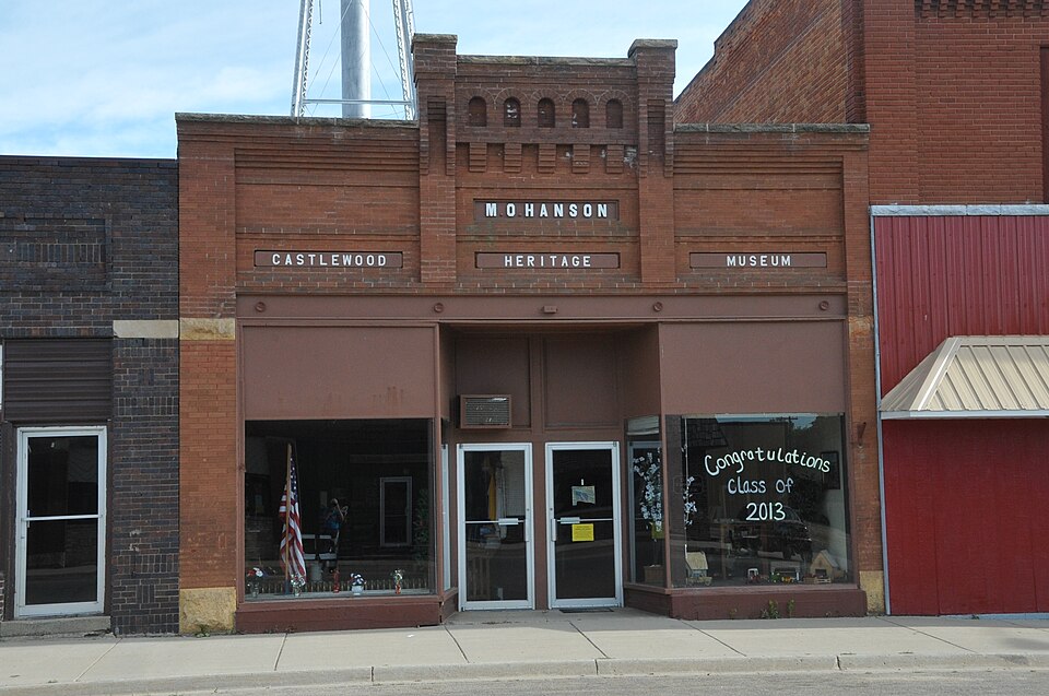
Built in 1907. Listed on the National Register of Historic Places in 2011.
One of 15 National Register listings published here for Hamlin County · listed in 2011 · category: Building · built in 1907.
Sources: the case file at the National Archives · the National Register database, National Park Service
Regional context, not property-specific evidence. The federal wildfire occurrence database lists 5 fires within 5 miles of M.O. Hanson Building between 2008 and 2016, burning about 142 acres in total. None started naturally. None was recorded as arson. Distance is straight-line from the map coordinates, so a fire counted here may appear on a neighbouring settlement's page as well.
| Reported cause | Fires |
|---|---|
| Equipment and vehicle use | 2 |
| Missing data/not specified/undetermined | 1 |
| Smoking | 1 |
| Debris and open burning | 1 |
The most recent of them, most recent first, with the day each was reported and the service that recorded it.
| Date | Cause | Size | Reported by | Name on the report |
|---|---|---|---|---|
| 29 September 2009 | Debris and open burning | 130 acres | South Dakota Wildland Fire Suppression | not named |
| 22 April 2008 | Smoking | 1.5 acres | South Dakota Wildland Fire Suppression | not named |
| 2 April 2016 | Missing data/not specified/undetermined | 5.0 acres | South Dakota Wildland Fire Suppression | RASMUSSEN |
| 29 October 2011 | Equipment and vehicle use | 1.0 acres | South Dakota Wildland Fire Suppression | GASRVER |
| 13 October 2011 | Equipment and vehicle use | 5.0 acres | South Dakota Wildland Fire Suppression | PETTERSON |
Regional context, not property-specific evidence. The federal mineral resources record lists 5 workings within 5 miles of M.O. Hanson Building: 5 past producers. None of them still produces. What was taken out: Sand and Gravel, Construction. Distance is straight-line from the map coordinates, so a quarry counted here may appear on a neighbouring settlement's page as well.
| Where | Site | Commodity | Status | Recorded |
|---|---|---|---|---|
| Gravel Pit | Sand and Gravel, Construction | Past Producer | ||
| Gravel Pit | Sand and Gravel, Construction | Past Producer | ||
| Gravel Pit | Sand and Gravel, Construction | Past Producer | ||
| Gravel Pit | Sand and Gravel, Construction | Past Producer | ||
| Gravel Pit | Sand and Gravel, Construction | Past Producer |
Regional context, not property-specific evidence. The National Weather Service names Castlewood, the town this property stands in, in 55 storm reports between 1995 and 2025: 32 hail, 8 thunderstorm wind, 7 flood, 4 flash flood. The reports record 3 injuries. Each account below is quoted exactly as the forecast office filed it, from the NOAA Storm Events Database, and each date opens the federal record of that event.
| When | Event | Place named | Harm | What the report says |
|---|---|---|---|---|
| June 2017 | Hail | Castlewood | 2 hurt | no account filed |
| May 2022 | Tornado (EF2) | Castlewood | 1 hurt | Several eyewitnesses reported a small funnel/tornado descending, widening and developing very rapidly at the edge of Castlewood, SD. Damage was evident as soon as it reached the southern edge of town. A majority of the damage occurred between 3rd Avenue and 4th Avenue. On Market Street, a small funeral home visitation center was completely blown off its foundation. Debris from the funeral home was tossed to the north, including the air conditioning unit which was tossed into a yard one block to the north. A garage was destroyed and completely blown from its foundation on Allen Street. The next block to the north, a home lost a roof and sustained significant damage to external walls. Another garage on this street was completely blown off the foundation and destroyed. Similar damage was noted a block north on Main Street. Another home lost an entire roof and partial collapse of external walls. Yet another garage was destroyed as it slid off the foundation. The next block north, on Alice Street, significant roof damage was noted to several homes and another garage was completely shifted off of the foundation. One particular residence had a roof that appeared to be slightly rotated and was sagging. The Castlewood Elementary school, situated between Harry Street and Pear Street, sustained significant damage to the school and gymnasium roof. Damage was also sustained to sections of the brick external walls. The school bus shed was completely destroyed with loss of|the roof and external walls. North of the school, on Prairie Street, a residence sustained significant damage. At this property, a garage was completely destroyed, and a shed was tossed in the air landing upside down. The home itself lost the entire roof and the |south facing external walls collapsed. The tornado would continue to track north across an open field and across US Highway 22. Additional debris and tree damage was noted a mile north of US Highway 22 before the tornado lifted. Throughout the entire path of the tornado there were uprooted and snapped trees and significant siding and roof damage to homes. |
| October 1996 | Tornado (F1) | Castlewood | $50,000 | no account filed |
| July 2025 | Flood | Castlewood | - | The Big Sioux River near Castlewood went into flood during the evening of July 27th, rising over three feet in four hours due to heavy rainfall from thunderstorms. The COOP observer in Castlewood recorded 5.61 inches of rain. The river crested at 11.44 feet, which is 2.44 feet above flood stage. The water inundated mainly farmland and pasture, and overtopped portions of 184th Street. The river remained in flood through the end of the month and into August. |
| August 2025 | Flood | Castlewood | - | The Big Sioux River near Castlewood entered flood stage around mid-day on August 6th. The river would crest at 1030 pm on August 7th at 10.63 feet, or 1.63 feet above flood stage. The river stayed in flood through the morning of August 10th. Flooding was mainly confined to low-lying agricultural lands north of Castlewood, though a portion of 184th street flooded. |
| August 2025 | Flood | Castlewood | - | The Big Sioux near Castlewood would go into flood on August 22nd during the morning hours, cresting at 11.42 or 2.42 feet above flood stage on the morning of August 24th. The river would remain in flood through the evening of August 27th. |
| July 2024 | Thunderstorm Wind | Castlewood | - | A member of the public reported tree branches down from thunderstorm winds estimated near 60 mph. |
| June 2017 | Thunderstorm Wind | Castlewood | - | Eighty mph winds downed multiple trees blocking the intersection of Highways 81 and 22. |
| June 2014 | Flash Flood | Castlewood | - | Heavy rains of up to 4 inches caused the flooding of a few roads south of Castlewood. |
| June 2014 | Flash Flood | Castlewood | - | Portions of county road 463 were underwater from flash flooding. |
| August 2012 | Thunderstorm Wind | Castlewood | - | Eighty mph winds downed between thirty and forty trees in Castlewood and Hayti. Many power outages were also reported. |
| August 2011 | Thunderstorm Wind | Castlewood | - | Sixty mph winds downed several branches along with a tree in Castlewood. |
| July 2005 | Thunderstorm Wind | Castlewood | - | Sixty mph winds downed many branches in Castlewood. |
| October 1997 | Thunderstorm Wind | Castlewood | - | Many trees were blown over and large hay bales weighing 1200 to 1500 pounds were pushed at least 50 yards. |
| June 2025 | Funnel Cloud | Castlewood | - | no account filed |
| June 2025 | Funnel Cloud | Castlewood | - | no account filed |
| June 2025 | Hail | Castlewood | - | no account filed |
| June 2025 | Hail | Castlewood | - | no account filed |
| July 2025 | Hail | Castlewood | - | no account filed |
| July 2025 | Hail | Castlewood | - | no account filed |
| July 2024 | Hail | Castlewood | - | no account filed |
| June 2024 | Flood | Castlewood | - | no account filed |
| May 2023 | Flood | Castlewood | - | no account filed |
| August 2021 | Thunderstorm Wind | Castlewood | - | no account filed |
| August 2015 | Hail | Castlewood | - | no account filed |
| July 2015 | Hail | Castlewood | - | no account filed |
| July 2011 | Hail | Castlewood | - | no account filed |
| July 2011 | Hail | Castlewood | - | no account filed |
| July 2011 | Hail | Castlewood | - | no account filed |
| July 2011 | Hail | Castlewood | - | no account filed |
| July 2011 | Hail | Castlewood | - | no account filed |
| March 2009 | Flood | Castlewood | - | no account filed |
| June 2008 | Thunderstorm Wind | Castlewood | - | no account filed |
| April 2007 | Hail | Castlewood | - | no account filed |
| September 2007 | Hail | Castlewood | - | no account filed |
| March 2007 | Flood | Castlewood | - | no account filed |
| May 2005 | Hail | Castlewood | - | no account filed |
| May 2005 | Hail | Castlewood | - | no account filed |
| May 2005 | Hail | Castlewood | - | no account filed |
| May 2005 | Hail | Castlewood | - | no account filed |
| May 2005 | Hail | Castlewood | - | no account filed |
| May 2005 | Hail | Castlewood | - | no account filed |
| March 2004 | Hail | Castlewood | - | no account filed |
| May 2004 | Hail | Castlewood | - | no account filed |
| July 2003 | Hail | Castlewood | - | no account filed |
| July 2003 | Hail | Castlewood | - | no account filed |
| August 2002 | Flash Flood | Castlewood | - | no account filed |
| August 2002 | Flash Flood | Castlewood | - | no account filed |
| August 2002 | Hail | Castlewood | - | no account filed |
| July 1999 | Hail | Castlewood | - | no account filed |
| June 1999 | Hail | Castlewood | - | no account filed |
| June 1998 | Hail | Castlewood | - | no account filed |
| June 1997 | Hail | Castlewood | - | no account filed |
| June 1997 | Hail | Castlewood | - | no account filed |
| June 1995 | Hail | Castlewood | - | no account filed |
No historic map-sheet match is published for this property yet. That does not mean no map exists. This record needs a coordinate-quality review before it can be joined to a sheet boundary. Browse the county's mapped places while that work is pending.
Other National Register properties close enough to walk or drive between, ordered by distance from this one. Both positions come from the same geocoding pass that matched these properties to their map sheets.
| Photograph | Property | Distance | Listed |
|---|---|---|---|
| South Dakota Dept. of Transportation Bridge No. 29-221-060 | 0.9 miles | 1993 | |
| South Dakota Dept. of Transportation Bridge No. 29-279-010 | 6.8 miles | 1993 |
| National Archives record | The nomination case file for reference 11000486 in Record Group 79. |
| Hamlin County | All 15 listed properties in this county. |