 Block
From the record
2 National Register listings published here.
Sources: the National Register database, National Park Service
36 topographic sheets cover 31 settlements here, and 2 properties are on the National Register of Historic Places.
2 National Register listings published here.
Sources: the National Register database, National Park Service
Every property in this county listed on the National Register of Historic Places, with the year it was listed and the federal nomination document.
| Photograph | Property | Type | Listed | Reference |
|---|---|---|---|---|
 | Clay County Courthouse | building | 1977 | 77001261 |
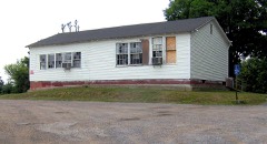 | Free Hills Rosenwald School | building | 1996 | 96001360 |
Every wildfire the federal occurrence database records inside this county: 61 of them, burning about 362 acres. None started naturally and 25 were recorded as arson. Each settlement page carries the fires within five miles of it.
| Reported cause | Fires |
|---|---|
| Debris and open burning | 32 |
| Arson/incendiarism | 25 |
| Missing data/not specified/undetermined | 2 |
| Equipment and vehicle use | 1 |
| Power generation/transmission/distribution | 1 |
The five largest, by the area the report gives. Four of them were set deliberately.
| Date | Cause | Size | Reported by | Name on the report |
|---|---|---|---|---|
| 8 March 2000 | Debris and open burning | 35 acres | Tennessee Division of Forestry | not named |
| 11 January 2000 | Arson/incendiarism | 29 acres | Tennessee Division of Forestry | not named |
| 30 March 2010 | Debris and open burning | 25 acres | Tennessee Division of Forestry | HWY 53 |
| 7 November 1998 | Arson/incendiarism | 22 acres | Tennessee Division of Forestry | not named |
| 14 April 2010 | Arson/incendiarism | 20 acres | Tennessee Division of Forestry | BAPTIST RIDGE RD |
| 17 February 1997 | Debris and open burning | 20 acres | Tennessee Division of Forestry | not named |
| 25 March 2000 | Arson/incendiarism | 18 acres | Tennessee Division of Forestry | not named |
| 18 February 1997 | Debris and open burning | 15 acres | Tennessee Division of Forestry | not named |
Every settlement page carries the fires within five miles of it - see the settlement index below.
The NOAA Storm Events Database holds 188 reports for this county, causing no deaths, 3 injuries and about $2,243,940 in recorded property damage. Each settlement page carries the reports that name it.
| Kind of event | Reports |
|---|---|
| Thunderstorm Wind | 123 |
| Hail | 34 |
| Flash Flood | 21 |
| Lightning | 4 |
| Flood | 3 |
| Tornado | 3 |
The most serious of them, by death, then injury, then recorded damage. The accounts are quoted exactly as the forecast office filed them.
| When | Event | Place named | Harm | What the report says |
|---|---|---|---|---|
| April 2011 | Thunderstorm Wind | Neely Xrds | 2 hurt, $10,000 | A concrete wall garage was destroyed and two trees were uprooted southeast of Celina along State Highway 52. Two minor injuries were also reported. |
| May 2018 | Lightning | Memorial | 1 hurt, $10,000 | Lightning struck a tree which caused a large limb to fall onto a vehicle on Clementsville Road between Moss and Hermitage Springs resulting in one minor injury. |
| December 2021 | Tornado (EF1) | Hermitage Spgs | $500,000 | This EF-1 tornado touched down in Hermitage Springs just south of Highway 52 where it uprooted trees. Moving along and just north of Highway 52, the tornado continued to blow down trees and causing shingle damage to multiple homes. The worst damage occurred along Old Clementsville Road where four large agricultural buildings were destroyed. The tornado continued northeast, damaging the roof of a home on Clementsville Road. Scattered tree damage was noted as the path continued into Monroe County, Kentucky, where it caused EF-0 damage to a barn and trees along Beech Groves Boles Road. The tornado continued to weaken as it moved northeast damaging a few trees before lifting near Verona Road east of Hestand, Kentucky. The path length in Tennessee was around 5.78 miles, with a total path length of 11.16 miles. |
| July 2015 | Flash Flood | Hermitage Spgs | $500,000 | Major flash flooding affected Clay County from the evening hours on July 2 into the morning hours on July 3. Numerous roads throughout the county were flooded and closed, including many in Celina such as Mitchell Street and others in Arcot. Several water rescues were also performed by emergency personnel, including one on Arcot Road. Homes and businesses were also flooded, mainly in and around Celina. A trailer home on Knob Creek Road was swept off its foundation and washed downstream in Knob Creek around 3 miles west of Celina. A CoCoRaHS observer 0.3 miles NNE of Celina measured 5.32 inches of rain over the 24 hour period ending at 8am on July 3. |
| March 2021 | Flash Flood | Celina | $238,640 | Numerous roads were flooded across Clay County, including Wet Mill Creek Road, Pitcock Lane, Kyle Street at West Lake Avenue, Williamson Street, Poor House Road, Free Hill River Road, Arcott Road, Turkey Creek Road, New Hope Road, Finus Cherry Road, Trace Creek Road, Leonard Road, Luther Pedigo Road, and Mack Bean Road. |
| May 2020 | Thunderstorm Wind | Celina | $123,700 | Numerous trees and power lines were blown down across Clay County. |
| June 2023 | Thunderstorm Wind | Hermitage Spgs | $50,000 | Severe thunderstorm winds downed several trees and power lines across Clay County with power outages also reported, especially in the Hermitage Springs area. Damages are a rough estimate. |
| December 2023 | Tornado (EF1) | Clementsville | $50,000 | A brief EF-1 tornado touched down just south of the Kentucky border in Clay County where it blew down a few trees on Barber Shop Road. The tornado intensified to an EF-1 as it moved northeast into Kentucky. |
| January 2013 | Thunderstorm Wind | Pea Ridge Store | $50,000 | State Highway 53 near mile marker 3 was closed due to trees down across the road. Trees and power lines were also downed across the following roads across the county: Union Hill, Mosey Purcel, Bakerton Pea Ridge, Firetower, Mccormick Ridge, and Commerce Street. Other trees and power lines were downed elsewhere in the county with damage to barn roofs and silos. |
| April 2011 | Thunderstorm Wind | Celina | $50,000 | Minor roof damage to two homes and small portion of siding peeled off walls of a couple other homes in Celina. Trees fell onto two other homes and caused roof damage. |
| April 2011 | Thunderstorm Wind | Celina | $50,000 | Trees and power lines were blown down in Celina and across much of Clay County. Roofs were blown off and other structures were damaged across the county also. Specific details concerning these roofs and structures damaged across the county were unknown. |
| July 2010 | Flash Flood | Hermitage Spgs | $50,000 | Roads were impassable with debris in roads and trees down due to flash flooding in Hermitage Springs. |
| May 2024 | Thunderstorm Wind | Celina | $25,000 | Severe thunderstorm winds downed several trees in Celina and caused roofing damage to a few outbuildings. Damages are a rough estimate. |
| October 2014 | Thunderstorm Wind | Celina | $25,000 | Widespread wind damage occurred in Celina with roof and siding damage to some homes. One downtown business had its roof blown off and front doors blown in. Numerous trees were snapped and uprooted with power lines blown down. |
| May 2012 | Thunderstorm Wind | Hermitage Spgs | $25,000 | Some trees were downed across the county. |
| July 2010 | Thunderstorm Wind | Dale Hollow | $25,000 | Numerous trees were blown down across Neeley Creek Road. |
| July 2009 | Flash Flood | Celina | $25,000 | Several city streets in Celina were flooded as well as a few secondary roads off State Highway 53 south of Celina. |
| June 2019 | Thunderstorm Wind | Free Hill | $20,000 | Trees and power lines were blown down across Clay County, including across Highway 52. Two homes had trees fall on them but no damage resulted. One downed power line caused a fire which burned an outdoor garage down to the ground at Neely Creek. |
| July 2015 | Tornado (EF0) | Pea Ridge Store | $20,000 | An EF0 tornado touched down in Cumberland County KY along Ashlock Road and moved southeast, crossing the border into Clay County TN along Poindexter Road. The tornado continued southeast along Ashlock Road before lifting near Highway 53. A few homes suffered roof damage and several outbuildings were damaged or destroyed. Numerous trees and power lines were blown down along the path. Maximum winds were estimated at 80 mph. The total path length for the tornado in KY and TN was 1.5 miles. |
| August 2025 | Thunderstorm Wind | Celina | $15,000 | Strong thunderstorm winds caused a rotten tree to fall onto a mobile home. A couple of other tree branches fell as well with one branch causing a power pole to lean. No injuries were reported. Damages are a rough estimate. |
| July 2024 | Thunderstorm Wind | Celina | $15,000 | A few trees and a 40-foot TV tower were blown down at Dale Hollow Lake. Damages are a rough estimate. |
| January 2020 | Thunderstorm Wind | Baptist Ridge | $15,000 | A NWS Nashville storm survey found a roughly 12 mile long path of sporadic straight-line wind damage ranging from 500 yards up to 3 miles wide, with damage mainly on the higher elevations along the path. Numerous trees were snapped and uprooted, and a few barns and outbuildings experienced roof and wall damage. All damage was blown towards the east-northeast or northeast with no evidence of convergence. Winds were estimated up to 85 mph. |
| December 2016 | Thunderstorm Wind | Celina | $15,000 | A tree fell through the roof at Cherry Tree Apartments. 2 people were displaced. |
| July 2012 | Thunderstorm Wind | Midway | $15,000 | Several trees were downed across the western half of the county, including downed tress on McCormick Ridge Road and other areas in the Union Hill community, and also on Baptist Ridge Road. |
| February 2009 | Thunderstorm Wind | Celina | $12,000 | Minor roof damage reported to a couple of homes. Trees and power lines were blown down county wide. |
| September 2025 | Thunderstorm Wind | Union Hill | $10,000 | Severe thunderstorm winds downed numerous trees on the west side of Clay County. Damages are a rough estimate. |
| May 2024 | Thunderstorm Wind | Celina | $10,000 | Severe thunderstorm winds downed trees on Mitchell Street in Celina. Damages are a rough estimate. |
| May 2024 | Thunderstorm Wind | Denton Xrds | $10,000 | Severe thunderstorm winds downed power lines along Highway 52 in Moss. Damages are a rough estimate. |
| April 2016 | Thunderstorm Wind | Celina | $10,000 | Numerous trees were blown down all across Clay County with numerous roads blocked. |
| December 2016 | Thunderstorm Wind | Hermitage Spgs | $10,000 | A tree was blown down on Highway 52 just east of the Macon County Line. A car ran into the tree on the roadway. |
| July 2015 | Thunderstorm Wind | Pea Ridge Store | $10,000 | A downburst associated with the hail core of a supercell thunderstorm blew down several trees along a path from Highway 53 in Pea Ridge southeastward to the Holly Creek Resort area. |
| February 2014 | Thunderstorm Wind | Dale Hollow | $10,000 | A home received roof damage on Old Highway 53 east of Celina. Multiple trees were also blown down in the area and a subdivision was without power. |
| May 2013 | Thunderstorm Wind | Celina | $10,000 | Several trees were reported down across the county with multiple power outages. |
| July 2012 | Thunderstorm Wind | Pea Ridge Store | $10,000 | A few trees were downed on roadways across the county. |
| July 2012 | Thunderstorm Wind | Union Hill | $10,000 | Several trees were downed on McCormick Ridge Road in the Union Hill Community. |
| June 2010 | Flash Flood | Celina | $10,000 | Heavy rainfall washed boulders onto State Highway 52 just outside of Celina. |
| May 2009 | Thunderstorm Wind | Celina | $10,000 | Trees were blown down blocking roads in downtown Celina. |
| June 2009 | Thunderstorm Wind | Dale Hollow | $10,000 | Trees were reported down at Dale Hollow Fish Hatchery. |
| January 2008 | Thunderstorm Wind | Moss | $10,000 | Newspaper reported a barn was destroyed in Moss. |
| April 2006 | Hail | Celina | $10,000 | Newspaper story said that golf ball size hail hit Celina, causing vehicles to have dents and dings. |
| July 2004 | Thunderstorm Wind | Countywide | $10,000 | Sheriff's office reported trees and power lines were down around the county. Numerous roads were blocked by fallen trees. Trees fell on houseboats at Horse Creek Dock. |
| June 2023 | Thunderstorm Wind | Dale Hollow | $5,000 | Severe thunderstorm winds knocked down multiple trees along Campground Road at Dale Hollow Dam Campground. Damages are a rough estimate. |
| June 2018 | Thunderstorm Wind | Hermitage Spgs | $5,000 | Several trees were blown down around Hermitage Springs including one that fell onto a car on Happy Springs Road at Highway 52. |
| May 2017 | Lightning | Union Hill | $5,000 | An outbuilding was struck by lightning at 3999 Union Hill Moss Road and set on fire. |
| May 2016 | Thunderstorm Wind | Celina | $5,000 | Dozens of mainly small trees were blown down all across Clay County. |
| July 2016 | Thunderstorm Wind | Celina | $5,000 | Numerous trees were blown down across Clay County. |
| August 2014 | Flash Flood | Celina | $5,000 | Clay County EMA reported heavy rainfall caused minor street flooding in Celina as well as flooded parts of the county jail. |
| May 2014 | Thunderstorm Wind | Hermitage Spgs | $5,000 | Numerous trees were reported down in the Hermitage Springs area. |
| July 2012 | Lightning | Bakerton | $5,000 | A lightning strike resulted in a grass fire that burned five acres of a field near Nimm Road close to the Clay/Macon County lines. |
| January 2008 | Thunderstorm Wind | Celina | $5,000 | Trees and power lines were down in the central and eastern part of the county. |
| October 2007 | Thunderstorm Wind | St John | $5,000 | Strong thunderstorm winds produced damage at the Willow Grove Marina on Dale Hollow Lake. Some pieces of the roof came off a pier where boats were stored and hit a houseboat. |
| May 1995 | Thunderstorm Wind | Moss | $5,000 | Many trees were blown bown. |
| May 1995 | Thunderstorm Wind | Oak Grove | $5,000 | Several buildings were damaged. Many trees were knocked down. |
| July 1995 | Thunderstorm Wind | Moss | $5,000 | Several power lines were knocked down. |
| July 2015 | Thunderstorm Wind | Baptist Ridge | $4,000 | Power lines and two trees were blown down on Buzzard Lane and Turkey Town Road. |
| June 2009 | Thunderstorm Wind | Pea Ridge Store | $4,000 | A couple of trees and power lines were reported downed in Pea Ridge. |
| July 2018 | Thunderstorm Wind | Midway | $3,000 | Several trees were blown down on Moss Arcot Road. |
| June 2018 | Thunderstorm Wind | Midway | $3,000 | Trees were blown down along New Hope Road. |
| November 2017 | Thunderstorm Wind | Celina | $3,000 | Clay County Sheriff's Office reported several trees were blown down throughout Clay County. |
| March 2017 | Thunderstorm Wind | Dale Hollow | $3,000 | A few trees were blown down outside of Celina on Highway 53 South, Highway 52, and Cedar Hill Road. |
The Survey's mineral resources record lists 27 workings inside this county. 2 still produce and 25 are closed or unrecorded. Each settlement page carries the workings within five miles of it.
| Commodity | Workings |
|---|---|
| Uranium, Oil Shale | 9 |
| Uranium | 9 |
| Oil Shale | 9 |
| Zinc | 4 |
| Stone, Crushed/Broken | 3 |
| Oil Shale, Uranium | 1 |
| Limestone, General | 1 |
The least common of them first, because a county's hundredth gravel pit says nothing its first ten did not.
| Where | Site | Commodity | Status | Recorded |
|---|---|---|---|---|
| County Quarry | Limestone, General | Past Producer | Sedimentary | |
| Outcrop Sample For Uranium | Oil Shale, Uranium | Occurrence | ||
| Celina Quarry | Stone, Crushed/Broken | Producer | ||
| County Quarry | Stone, Crushed/Broken | Past Producer | ||
| Dixie Limestone Co. Quarry | Stone, Crushed/Broken | Producer | Limestone | |
| Deep Well-Sphalerite Occurrence | Zinc | Occurrence | Sphalerite | |
| Deep Well-Sphalerite Occurrence | Zinc | Occurrence | Sphalerite | |
| Deep Well-Sphalerite Occurrence | Zinc | Occurrence | ||
| Deep Well-Sphalerite Occurrence | Zinc | Occurrence | ||
| Outcrop Sample For Uranium | Uranium, Oil Shale | Occurrence | ||
| Outcrop Sample For Uranium | Uranium, Oil Shale | Occurrence | ||
| Outcrop Sample For Uranium | Uranium, Oil Shale | Occurrence | ||
| Outcrop Sample For Uranium | Uranium, Oil Shale | Occurrence | ||
| Outcrop Sample For Uranium | Uranium, Oil Shale | Occurrence | ||
| Outcrop Sample For Uranium | Uranium, Oil Shale | Occurrence | ||
| Outcrop Sample For Uranium | Uranium, Oil Shale | Occurrence | ||
| Outcrop Sample For Uranium | Uranium, Oil Shale | Occurrence | ||
| Outcrop Sample For Uranium | Uranium, Oil Shale | Occurrence | ||
| Outcrop Sample For Uranium | Uranium, Oil Shale | Occurrence | ||
| Outcrop Sample For Uranium | Uranium, Oil Shale | Occurrence | ||
| Outcrop Sample For Uranium | Uranium, Oil Shale | Occurrence | ||
| Outcrop Sample For Uranium | Uranium, Oil Shale | Occurrence | ||
| Outcrop Sample For Uranium | Uranium, Oil Shale | Occurrence | ||
| Outcrop Sample For Uranium | Uranium, Oil Shale | Occurrence | ||
| Outcrop Sample For Uranium | Uranium, Oil Shale | Occurrence | ||
| Outcrop Sample For Uranium | Uranium, Oil Shale | Occurrence | ||
| Outcrop Sample For Uranium | Uranium, Oil Shale | Occurrence |
Named settlements recorded in the Geographic Names Information System, each with the topographic sheets covering it. Villages, hamlets and abandoned places alike. Each is shown with the nearest named watercourse or landform and the survey quadrangle it falls on.
District 3 · 38551 · On Tinsley Branch · Dale Hollow Dam quadrangle
14 sheets, 1924 to 1985
District 2 · 37150 · On Hurricane Creek · Union Hill quadrangle
11 sheets, 1929 to 1985
District 2 · 37150 · On Hurricane Creek · Union Hill quadrangle
11 sheets, 1929 to 1985
District 4 · 38541 · On Sidwell Creek · Dale Hollow Reservoir SE quadrangle
13 sheets, 1924 to 1985
District 4 · 38541 · On Mitchell Creek · Dale Hollow Dam quadrangle
14 sheets, 1924 to 1985
No longer a settlement
District 3 · 38551 · Near Hamilton Hollow · Dale Hollow Dam quadrangle
14 sheets, 1924 to 1985
District 2 · 37150 · On Bean Branch · Red Boiling Springs quadrangle
10 sheets, 1931 to 1985
District 2 · 37150 · On Wilson Branch · Red Boiling Springs quadrangle
10 sheets, 1931 to 1985
District 5 · 38551 · Near Boys Island · Dale Hollow Reservoir SE quadrangle
13 sheets, 1924 to 1985
No longer a settlement
District 4 · 38551 · Near Burchett Hollow · Dale Hollow Dam quadrangle
14 sheets, 1924 to 1985
District 4 · 38541 · Near Geiger Island · Dale Hollow Reservoir SE quadrangle
13 sheets, 1924 to 1985
District 4 · 38551 · On Gap Branch · Dale Hollow Dam quadrangle
14 sheets, 1924 to 1985
District 5 · 38551 · Near Grogan Hill · Dale Hollow Dam quadrangle
14 sheets, 1924 to 1985
District 5 · 38575 · On Turkey Creek · Burristown quadrangle
11 sheets, 1925 to 1982
No longer a settlement
District 4 · 38568 · On Right Fork Dry Fork · Burristown quadrangle
11 sheets, 1925 to 1982
No longer a settlement
District 4 · 38541 · On Colson Creek · Dale Hollow Reservoir SE quadrangle
13 sheets, 1924 to 1985
The vanished settlements of Clay County: the places named above that are no longer on the map.