 Block
From the record
3 National Register listings published here.
Sources: the National Register database, National Park Service
28 topographic sheets cover 32 settlements here, and 3 properties are on the National Register of Historic Places.
3 National Register listings published here.
Sources: the National Register database, National Park Service
Every property in this county listed on the National Register of Historic Places, with the year it was listed and the federal nomination document.
| Photograph | Property | Type | Listed | Reference |
|---|---|---|---|---|
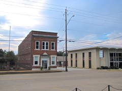 | Bank of Alamo | building | 1986 | 86001397 |
| Central High School | building | 2025 | 100011616 | |
| Fruitvale Historic District | district | 2012 | 12000943 |
Every wildfire the federal occurrence database records inside this county: 9 of them, burning about 163 acres. None started naturally and 1 was recorded as arson. Each settlement page carries the fires within five miles of it.
| Reported cause | Fires |
|---|---|
| Debris and open burning | 7 |
| Arson/incendiarism | 1 |
| Equipment and vehicle use | 1 |
The five largest, by the area the report gives. One of them was set deliberately.
| Date | Cause | Size | Reported by | Name on the report |
|---|---|---|---|---|
| 23 August 2007 | Debris and open burning | 47 acres | Tennessee Division of Forestry | HUMBOLDT LAKE |
| 23 June 2012 | Arson/incendiarism | 44 acres | Tennessee Division of Forestry | BRIMS CORNER |
| 23 January 2009 | Debris and open burning | 19 acres | Tennessee Division of Forestry | GADSDEN FIRE |
| 11 March 2002 | Debris and open burning | 16 acres | Tennessee Division of Forestry | not named |
| 28 February 2016 | Debris and open burning | 15 acres | Tennessee Division of Forestry | ALEX`S FIRST |
| 14 October 2010 | Debris and open burning | 12 acres | Tennessee Division of Forestry | OTHA FIRE |
| 30 September 2011 | Debris and open burning | 7.0 acres | Tennessee Division of Forestry | MAURY CITY |
| 9 September 2011 | Equipment and vehicle use | 3.0 acres | Tennessee Division of Forestry | CARRY |
Every settlement page carries the fires within five miles of it - see the settlement index below.
The NOAA Storm Events Database holds 177 reports for this county, causing 3 deaths, 19 injuries and about $19,773,860 in recorded property damage. Each settlement page carries the reports that name it.
| Kind of event | Reports |
|---|---|
| Thunderstorm Wind | 87 |
| Flash Flood | 36 |
| Hail | 33 |
| Tornado | 12 |
| Flood | 7 |
| Lightning | 1 |
| Heavy Rain | 1 |
The most serious of them, by death, then injury, then recorded damage. The accounts are quoted exactly as the forecast office filed them.
| When | Event | Place named | Harm | What the report says |
|---|---|---|---|---|
| April 1963 | Tornado (F3) | not stated | 3 killed, 6 hurt, $250,000 | no account filed |
| April 1975 | Tornado (F1) | not stated | 6 hurt, $250,000 | no account filed |
| January 1999 | Tornado (F3) | Alamo | 4 hurt, $1,600,000 | The tornado began just south of Alamo and tracked northeast damaging the south side of Alamo before moving into rural areas. Eleven conventional homes, five mobile homes and one commercial building were destroyed. Seventy-three other homes and buildings were damaged. |
| April 1998 | Tornado (F2) | Maury City | 2 hurt, $172,000 | The tornado touched down in Maury City and moved northeast toward Crockett Mills. One mobile home was destroyed. Seven houses were damaged. Five farm sheds were destroyed. Several trees were blown down. |
| February 2016 | Tornado (EF1) | Cross Rd | 1 hurt, $150,000 | The tornado snapped or uprooted several trees southwest of, and at the Crockett County Golf Club. It caused roof damage to a mobile home and a permanent structure just south of Highway 412. Two tractor trailers were overturned on Highway 412, with one driver injured. North of Highway 412, the tornado damaged several storage sheds and caused roof damage to several homes. The tornado then crossed Highway 88 and caused roof damage to several buildings at the Crockett County High School. The tornado damaged additional storage sheds and a home roof on the east side of North Cavalier Drive before dissipating. Peak estimated wind was 95 mph. |
| May 2010 | Flash Flood | Elizabeth | $14,000,000 | Very heavy rain up to 20 inches produced devastating flooding across Crockett County. As many as 25 roads and bridges were flooded or washed out. At the peak of the flooding, most of the county roads were closed. Some rescues occurred from the flood waters. In total, 49 houses sustained some kind of flood damage. Of those, thirteen were completely destroyed. Three businesses were damaged as well. A few apartment complexes, farm buildings and other structures were affected by the flood waters. The flash flood event transitioned into a flood event by late in the afternoon as heavy rain allowed rivers to rapidly rise and overflow their banks. |
| November 2002 | Thunderstorm Wind | Bells | $1,500,000 | Strong straight line winds damaged a nursing home in the town of Bells. The damage forced 120 residents in the home to be evacuated. Some trees and power lines were also knocked down. |
| November 2002 | Tornado (F2) | Bells | $750,000 | A tornado touched down just northeast of Bells and tracked northeast. Six mobile homes and four houses were destroyed. Another 62 homes and several businesses were damaged. Many trees and power poles were blown down. |
| November 2005 | Tornado (F1) | Friendship | $200,000 | The tornado touched down northeast of Friendship and track northeast eventually moving into Gibson County. One house was shifted off of its foundation. Some homes suffered shingle damage. Several mobile homes and utility sheds were also damaged. |
| May 2003 | Thunderstorm Wind | Alamo | $100,000 | Twenty homes and several cars were damaged. Parts of Crockett County High School were damaged. Several shop buildings were destroyed. Some trees and power lines were knocked down. |
| April 2011 | Thunderstorm Wind | Alamo | $95,000 | Straight line winds destroyed two mobile homes and damaged two others in Crockett County. A house also suffered minor damage. |
| July 2009 | Flash Flood | Alamo | $60,000 | A Coop Observer reported seven inches of rain in a three hour period in Alamo. A ten apartment unit complex on West Church Street had four inches of water inside. A Church of Christ was also flooded. Downtown streets has 12-14 inches of water over them. One car was stalled as a result. |
| February 2019 | Flash Flood | Bells | $50,000 | Bells is completely under water. Stalled vehicles in the road. |
| May 2001 | Thunderstorm Wind | Alamo | $50,000 | Several homes were damaged. Many trees were blown down. |
| March 2026 | Thunderstorm Wind | Elmore | $25,000 | Multiple trees and power poles were knocked down throughout the county. Widespread power outages due to downed trees and power poles in Alamo. |
| May 1979 | Tornado (F2) | not stated | $25,000 | no account filed |
| April 2025 | Thunderstorm Wind | Bells | $20,000 | Trees snapped causing minor damage to the roof and trim of a home. |
| June 2018 | Thunderstorm Wind | Bells | $20,000 | Power-lines and trees down near Bells and Cypress communities. A shed was also destroyed. |
| April 2006 | Hail | Maury City | $20,000 | no account filed |
| April 2006 | Hail | Bells | $16,000 | no account filed |
| May 2025 | Thunderstorm Wind | Maury City | $15,000 | Trees and powerlines downed. |
| April 2025 | Thunderstorm Wind | Broadview | $15,000 | Tree trunks were snapped, and an outpost building was damaged. |
| August 2024 | Thunderstorm Wind | Maury City | $15,000 | A tree was knocked down on to a home in Maury City. |
| June 2017 | Thunderstorm Wind | Gadsden | $15,000 | Trees reported down with one tree falling on a shed. |
| April 2003 | Thunderstorm Wind | Maury City | $15,000 | Many trees and power lines were blown down. |
| April 2002 | Thunderstorm Wind | Alamo | $15,000 | A building and some trees were blown down. |
| May 2000 | Thunderstorm Wind | Countywide | $15,000 | Several buildings were damaged. Some trees were blown down. |
| May 2000 | Thunderstorm Wind | Alamo | $15,000 | Several trees and power lines were blown down. Some of the downed trees fell on houses. |
| May 1998 | Thunderstorm Wind | Bells | $15,000 | A newly renovated mobile home was destroyed. One house had its chimney knocked off by a tree limb. |
| April 2026 | Thunderstorm Wind | Gum Flat | $10,000 | Trees and power lines were knocked down along Joe Edwards Road east of Bells. |
| April 2025 | Tornado (EF1) | Friendship | $10,000 | A brief tornado touched down just south of Mount Moriah Church Road, south of the town of Friendship during the early morning hours of April 5th. The tornado caused some minor tree damage along this road, before continuing northward along East Road. Just south of Highway 412, additional tree damage was observed. The tornado continued northward just to the east of the town of Friendship, causing a tree to be uprooted along Friendship Eaton Road. The tornado lifted shortly after. Peak winds were estimated at 95 mph. |
| February 2023 | Flash Flood | Elizabeth | $10,000 | Elizabeth Road was washed out between Jerald White Road and Harbor Road. |
| June 2022 | Thunderstorm Wind | Mason Grove | $10,000 | A couple of large trees down, minor roof damage. |
| February 2018 | Flash Flood | Maury City | $10,000 | State route 189 was flooded at Old Mounds Road. |
| August 2010 | Flash Flood | Alamo | $10,000 | Heavy rain produced flash flooding near Alamo that eventually led to a bridge being partially washed out. |
| May 2009 | Thunderstorm Wind | Crockett Mills | $10,000 | Straight line winds knocked down several trees in the Providence Church area along Highway 188 near Crockett Mills. A tractor shed was also damaged and a roof was torn off a barn. |
| October 2007 | Lightning | Friendship | $10,000 | A house was damaged by a fire started by lightning. |
| October 2007 | Thunderstorm Wind | Maury City | $10,000 | Several trees and power lines were blown down. |
| August 2005 | Thunderstorm Wind | Alamo | $10,000 | Many trees were knocked down. |
| October 2004 | Thunderstorm Wind | Friendship | $10,000 | Several trees and power lines were blown down. |
| May 2003 | Thunderstorm Wind | Alamo | $10,000 | The roof of a business was blown off. |
| May 2003 | Thunderstorm Wind | Friendship | $10,000 | Some trees and power lines were blown down. |
| June 2003 | Thunderstorm Wind | Johnsons Grove | $10,000 | A shed was blown down. Some tree limbs and power lines were knocked down. |
| June 1995 | Thunderstorm Wind | not stated | $10,000 | Numerous trees were knocked down. |
| April 2025 | Thunderstorm Wind | Bells | $8,000 | A tree fell on a home in the 1400 block of Lower Jackson Rd in Bells. |
| April 2025 | Thunderstorm Wind | Maury City | $5,000 | Large metal shop blown over. |
| January 2012 | Thunderstorm Wind | Friendship | $5,000 | A carport was destroyed in the town of Friendship. |
| May 2010 | Tornado (EF0) | Gadsden | $5,000 | A weak tornado touched down briefly near Gadsden snapping off many pine trees 10 to 20 feet above the ground. |
| June 2009 | Thunderstorm Wind | Bells | $5,000 | Straight line winds destroyed outbuildings and knocked a tree on to a home about 1 mile east of Bells. |
| January 2005 | Thunderstorm Wind | Alamo | $5,000 | Several trees were knocked down. |
| July 2004 | Thunderstorm Wind | Gadsden | $5,000 | Several trees were blown down. |
| April 2003 | Thunderstorm Wind | Friendship | $5,000 | One structure lost its roof. Some trees were knocked down. |
| May 2003 | Thunderstorm Wind | Alamo | $5,000 | Some trees were blown down over a road. |
| July 2002 | Thunderstorm Wind | Alamo | $5,000 | A couple of trees were knocked down. |
| March 1999 | Thunderstorm Wind | Countywide | $5,000 | Several trees were knocked down across the county. |
| May 1999 | Thunderstorm Wind | Bells | $5,000 | Some trees were knocked down. |
| May 1998 | Flash Flood | Alamo | $5,000 | Heavy rain produced flash flooding in the Alamo area. Several roads were flooded. |
| May 1995 | Thunderstorm Wind | Southern Crockett | $5,000 | Several trees and signs were knocked down. |
| June 1995 | Thunderstorm Wind | Friendship | $5,000 | Several trees and power lines were blown down. |
| November 1995 | Thunderstorm Wind | Johnson Grove | $5,000 | Several trees and power lines were blown down. |
Named settlements recorded in the Geographic Names Information System, each with the topographic sheets covering it. Villages, hamlets and abandoned places alike. Each is shown with the nearest named watercourse or landform and the survey quadrangle it falls on.
District 10 · 38006 · Near Island Number Thirteen (historical) · Bells quadrangle
8 sheets, 1956 to 1986
District 2 · 38040 · On Black Creek · Chestnut Bluff quadrangle
9 sheets, 1939 to 1986
District 2 · 38040 · Near Island Number Eight (historical) · Chestnut Bluff quadrangle
9 sheets, 1939 to 1986
District 1 · 38034 · On Tucker Creek · Maury City quadrangle
7 sheets, 1956 to 1986
No longer a settlement
The vanished settlements of Crockett County: the places named above that are no longer on the map.