 Block
From the record
10 National Register listings published here.
Sources: the National Register database, National Park Service
69 topographic sheets cover 63 settlements here, and 10 properties are on the National Register of Historic Places.
10 National Register listings published here.
Sources: the National Register database, National Park Service
Every property in this county listed on the National Register of Historic Places, with the year it was listed and the federal nomination document.
| Photograph | Property | Type | Listed | Reference |
|---|---|---|---|---|
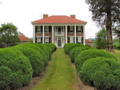 | William Cocke House | building | 1980 | 80003799 |
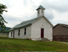 | Henderson Chapel African Methodist Episcopal Zion Church | building | 2000 | 00000730 |
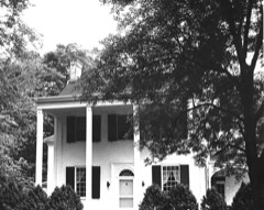 | Lea Springs | building | 1975 | 75001754 |
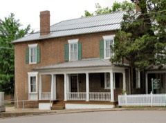 | Nance Building | building | 1998 | 98000824 |
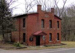 | Old Grainger County Jail | building | 2015 | 15000446 |
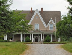 | Poplar Hill | building | 1980 | 80003798 |
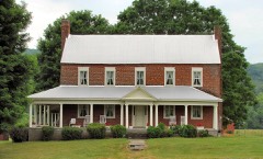 | Richland | district | 2014 | 14000941 |
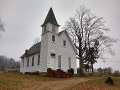 | Rutledge Presbyterian Church and Cemetery | building | 2015 | 15000447 |
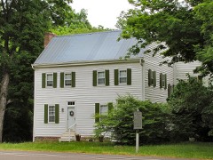 | Shields' Station | building | 1973 | 73001769 |
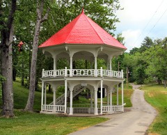 | Tate Springs Springhouse | structure | 1973 | 73001768 |
Every wildfire the federal occurrence database records inside this county: 147 of them, burning about 2,159 acres. 2 started naturally and 43 were recorded as arson. Each settlement page carries the fires within five miles of it.
| Reported cause | Fires |
|---|---|
| Debris and open burning | 52 |
| Arson/incendiarism | 43 |
| Missing data/not specified/undetermined | 26 |
| Smoking | 9 |
| Other causes | 7 |
| Power generation/transmission/distribution | 4 |
| Equipment and vehicle use | 2 |
| Natural | 2 |
| Recreation and ceremony | 1 |
| Fireworks | 1 |
The five largest, by the area the report gives. Three of them were set deliberately.
| Date | Cause | Size | Reported by | Name on the report |
|---|---|---|---|---|
| 15 September 2005 | Missing data/not specified/undetermined | 650 acres | Tennessee Division of Forestry | CLINCH MOUNTAIN |
| 17 November 2016 | Arson/incendiarism | 294 acres | Tennessee Division of Forestry | OLD MOUNTAIN ROAD FIRE |
| 3 December 2012 | Equipment and vehicle use | 184 acres | Tennessee Division of Forestry | JAPPA MTN FIRE |
| 16 March 2013 | Power generation/transmission/distribution | 122 acres | Tennessee Division of Forestry | LEA LAKE FIRE1 |
| 10 April 2006 | Arson/incendiarism | 90 acres | Tennessee Division of Forestry | not named |
| 20 August 2008 | Missing data/not specified/undetermined | 48 acres | Tennessee Division of Forestry | not named |
| 30 March 2006 | Arson/incendiarism | 46 acres | Tennessee Division of Forestry | not named |
| 28 February 2014 | Missing data/not specified/undetermined | 40 acres | Tennessee Division of Forestry | SPRINGBROOK LANE FIRE |
Every settlement page carries the fires within five miles of it - see the settlement index below.
The NOAA Storm Events Database holds 232 reports for this county, causing 1 death, 2 injuries and about $2,312,500 in recorded property damage. Each settlement page carries the reports that name it.
| Kind of event | Reports |
|---|---|
| Thunderstorm Wind | 180 |
| Hail | 35 |
| Flood | 6 |
| Flash Flood | 5 |
| Tornado | 4 |
| Lightning | 2 |
The most serious of them, by death, then injury, then recorded damage. The accounts are quoted exactly as the forecast office filed them.
| When | Event | Place named | Harm | What the report says |
|---|---|---|---|---|
| July 1997 | Flash Flood | Buffalo Spgs | 1 killed | no account filed |
| October 1977 | Tornado (F0) | not stated | 2 hurt, $250,000 | no account filed |
| February 2019 | Flood | Lea Spgs | $700,000 | Flooding at Little Valley Rd and Smith Hollow Rd. All told, there was about 700 thousand dollars in flood damages across Grainger County during the overall event. |
| July 1997 | Lightning | Central Portion | $150,000 | no account filed |
| February 2025 | Tornado (EF1) | Thorn Hill | $100,000 | The tornado began near McAnally Rd and Campground Rd before moving east along Highway 131. Tree damage began sporadically at first, with a few cedar trees split or blown over, tree damage then began to intensify towards the heart of the damage path. There were several barns and outbuildings with roof damage along 131, and numerous snapped trees. A small chicken coop was lofted up and over the pen around the coop, and left upside down in a ditch but with no scratches or visible damage to the coop. The most significant damage was to a large barn on Highway 131 that was completely destroyed. The tornado continued to Clinch River Hardwoods and Thorn Hill Church. At that location a large tanker trailer was overturned, and the church had some light damage to siding and windows. The tornado lifted where trees were snapped on the side of Clinch Mountain near US Highway 25E. |
| May 2024 | Hail | Rutledge | $100,000 | Several reports of tennis ball sized hail from both broadcast media and public reports were received. Significant damage was inflicted in Grainger County, with farmers reporting their tomato greenhouses were significantly damaged by the hail. |
| February 2011 | Flood | Rutledge | $80,000 | Trainer spotter reported 1.81 of rain fell from a thunderstorm producing flooding across many streams in the Rutledge area. |
| May 2005 | Thunderstorm Wind | Countywide | $35,000 | no account filed |
| June 2008 | Thunderstorm Wind | Thorn Hill | $25,000 | Trained spotter reported a roof was blown off a single wide trailer by thunderstorm winds on the intersection of 11W and 25E east of Tazewell. |
| May 2006 | Thunderstorm Wind | Rutledge | $25,000 | no account filed |
| July 2005 | Thunderstorm Wind | Bean Station | $25,000 | no account filed |
| May 2002 | Thunderstorm Wind | Washburn | $25,000 | no account filed |
| July 2002 | Thunderstorm Wind | Rutledge | $25,000 | no account filed |
| July 2006 | Thunderstorm Wind | Countywide | $24,000 | no account filed |
| June 2011 | Thunderstorm Wind | Rutledge | $20,000 | A trained spotter reported numerous trees downed by thunderstorm wind in Rutledge. |
| June 2004 | Thunderstorm Wind | Blaine | $20,000 | Home under construction on Richland Road totally demolished |
| June 1995 | Thunderstorm Wind | Blaine | $20,000 | A 68-foot high sycamore tree, certified by the state as the fourth largest sycamore tree, was toppled. Other trees and power lines were knocked down. Some of the fallen trees damaged vehicles and the roofs of several homes. |
| July 2006 | Thunderstorm Wind | Rutledge | $20,000 | no account filed |
| September 2006 | Thunderstorm Wind | Bean Station | $20,000 | no account filed |
| May 2005 | Thunderstorm Wind | Rutledge | $20,000 | no account filed |
| July 2004 | Thunderstorm Wind | Countywide | $20,000 | no account filed |
| May 2002 | Thunderstorm Wind | Countywide | $20,000 | no account filed |
| July 2002 | Thunderstorm Wind | Rutledge | $20,000 | no account filed |
| February 2009 | Thunderstorm Wind | Buffalo Spgs | $18,000 | A trained spotter reported several trees and powerlines downed by thunderstorm winds in Buffalo Springs. |
| October 2005 | Thunderstorm Wind | Rutledge | $18,000 | Several trees and powerlines downed in the Rutledge area. |
| June 2011 | Thunderstorm Wind | Bean Station | $15,000 | Law enforcement personnel reported multiple trees downed by thunderstorm wind in Bean Station. |
| June 2009 | Thunderstorm Wind | Lulaville | $15,000 | Law enforcement officials reported numerous trees downed by thunderstorm winds countywide. |
| April 2007 | Thunderstorm Wind | Buffalo Spgs | $15,000 | Five trees were reported down at the Buffalo Springs wildlife management area five miles southwest of Rutledge. |
| June 2004 | Thunderstorm Wind | Rutledge | $15,000 | Several trees down countywide |
| January 2006 | Thunderstorm Wind | Blaine | $15,000 | no account filed |
| July 2006 | Thunderstorm Wind | Rutledge | $15,000 | no account filed |
| May 2004 | Thunderstorm Wind | Bean Station | $15,000 | no account filed |
| May 2004 | Thunderstorm Wind | Buffalo Spgs | $15,000 | no account filed |
| May 2004 | Thunderstorm Wind | Rutledge | $15,000 | no account filed |
| June 2003 | Thunderstorm Wind | Countywide | $15,000 | no account filed |
| June 1997 | Thunderstorm Wind | Countywide | $14,000 | Numerous trees and powerlines down throughout the county. |
| February 2014 | Thunderstorm Wind | Bean Station | $12,000 | Law enforcement reported a few trees and powerlines trees downed by thunderstorm wind across the county. |
| June 2010 | Thunderstorm Wind | Rutledge | $12,000 | Law enforcement personnel reported numerous trees downed by thunderstorm winds in Rutledge. |
| April 2006 | Thunderstorm Wind | Buffalo Spgs | $12,000 | Several trees down countywide |
| July 2006 | Thunderstorm Wind | Countywide | $12,000 | no account filed |
| July 2005 | Thunderstorm Wind | Bean Station | $12,000 | no account filed |
| June 2003 | Thunderstorm Wind | Countywide | $12,000 | no account filed |
| June 2003 | Thunderstorm Wind | Bean Station | $12,000 | no account filed |
| February 2000 | Thunderstorm Wind | Rutledge | $12,000 | no account filed |
| January 2002 | Thunderstorm Wind | Countywide | $11,000 | Trees and power lines down. |
| June 2008 | Thunderstorm Wind | Rutledge | $10,000 | Dispatch reported 6 trees downed by thunderstorm winds in and around Rutledge. |
| June 2006 | Thunderstorm Wind | Countywide | $10,000 | Five trees down countywide. |
| June 2006 | Thunderstorm Wind | Blaine | $10,000 | A few trees down on powerlines east of Blaine. |
| June 2005 | Thunderstorm Wind | Rutledge | $10,000 | Two trees down west of Rutledge. |
| June 2004 | Thunderstorm Wind | Blaine | $10,000 | Three large trees down in Blaine |
| August 1995 | Thunderstorm Wind | Buffalo Springs | $10,000 | Several trees and powerlines knocked down. |
| July 2006 | Thunderstorm Wind | Rutledge | $10,000 | no account filed |
| May 2004 | Thunderstorm Wind | Rutledge | $10,000 | no account filed |
| July 2004 | Thunderstorm Wind | Rutledge | $10,000 | no account filed |
| November 2002 | Thunderstorm Wind | Rutledge | $10,000 | no account filed |
| April 2002 | Hail | Tate Spgs | $10,000 | no account filed |
| July 1996 | Thunderstorm Wind | Bean Station | $10,000 | no account filed |
| April 1996 | Thunderstorm Wind | Rutledge | $10,000 | no account filed |
| February 2012 | Thunderstorm Wind | Blaine | $8,000 | High department personnel reported several trees downed by thunderstorm wind near Blaine. |
| August 2006 | Thunderstorm Wind | Buffalo Spgs | $8,000 | Several trees down in Buffalo Springs. |
The Survey's mineral resources record lists 27 workings inside this county. 5 still produce and 22 are closed or unrecorded. Each settlement page carries the workings within five miles of it.
| Commodity | Workings |
|---|---|
| Zinc | 13 |
| Manganese | 7 |
| Stone, Crushed/Broken | 3 |
| Marble, Dimension | 2 |
| Limestone, General, Stone, Crushed/Broken | 1 |
| Iron, Zinc | 1 |
| Iron | 1 |
| Limestone, General | 1 |
| Iron, Barium-Barite | 1 |
The least common of them first, because a county's hundredth gravel pit says nothing its first ten did not.
| Where | Site | Commodity | Status | Recorded |
|---|---|---|---|---|
| Dalton Prospect | Zinc, Iron | Prospect | breccia filling | |
| Idol Comstock | Zinc, Iron, Barium-Barite | Past Producer | 1920 | |
| Jones Quarry | Limestone, General | Past Producer | Sedimentary | |
| Mitchell Quarry | Limestone, General, Stone, Crushed/Broken | Producer | Limestone | |
| Thorn Hill Prospect | Iron, Zinc | Occurrence | Pyrite, Sphalerite | |
| Imperial Black Marble Quarry | Marble, Dimension | Producer | 1944 | |
| Imperial Black Marble Quarry | Marble, Dimension | Producer | ||
| Jones Quarry | Stone, Crushed/Broken | Past Producer | ||
| Mitchell Quarry | Stone, Crushed/Broken | Producer | ||
| Richland | Zinc, Stone, Crushed/Broken | Prospect | 1953 | |
| Frye Prospect | Manganese | Prospect | 1918 | |
| Harmon Prospect | Manganese | Prospect | 1918 | |
| Rutledge Mine | Manganese | Past Producer | Residual | |
| Rutledge Mine | Manganese | Past Producer | 1918 | |
| Swann Prospect | Manganese | Occurrence | ||
| Waller Prospect | Manganese | Occurrence | ||
| Young Prospect | Manganese | Occurrence | ||
| Beech Grove Zinc Occurrence | Zinc | Occurrence | fracture filling; gash vein | |
| Clinch Valley | Zinc | Producer | 1950, 1977 | |
| Idol Mill | Zinc | Past Producer | ||
| L.L. Mallicoat Prospect | Zinc | Occurrence | 1912 | |
| Owl Hole Gap | Zinc | Unknown | ||
| Owl Hole Gap Occurrence | Zinc | Occurrence | Sphalerite | |
| Puncheon Camp Zinc Occurrence | Zinc | Occurrence | Sphalerite | |
| W.S. Mallicoat Prospect | Zinc | Prospect | 1918 | |
| Washburn Station | Zinc | Prospect | ||
| Washburn Station Occurrence | Zinc | Occurrence | Sphalerite |
Named settlements recorded in the Geographic Names Information System, each with the topographic sheets covering it. Villages, hamlets and abandoned places alike. Each is shown with the nearest named watercourse or landform and the survey quadrangle it falls on.
District 3 · 37861 · Near Indian Ridge · Joppa quadrangle
17 sheets, 1897 to 1981
No longer a settlement
District 4 · 37888 · Near Bob Hollow · Powder Springs quadrangle
16 sheets, 1897 to 1981
No longer a settlement
District 4 · 37888 · Near Log Mountain · Powder Springs quadrangle
16 sheets, 1897 to 1981
No longer a settlement
District 2 · 37861 · Near Poor Valley Ridge · Avondale quadrangle
20 sheets, 1883 to 1981
District 4 · 37881 · Near Jackson Hollow · Swan Island quadrangle
17 sheets, 1883 to 1981
District 5 · 37708 · On Meadow Branch · Bean Station quadrangle
21 sheets, 1883 to 1981
District 4 · 37888 · Near Hogskin Valley · Dutch Valley quadrangle
17 sheets, 1897 to 1981
District 4 · 37888 · Dutch Valley quadrangle
17 sheets, 1897 to 1981
No longer a settlement
District 4 · 37888 · On Dutch Valley Creek · Dutch Valley quadrangle
17 sheets, 1897 to 1981
No longer a settlement
District 3 · 37709 · On Highland Springs Branch · Luttrell quadrangle
17 sheets, 1897 to 1981
District 3 · 37861 · On Highland Springs Branch · Luttrell quadrangle
17 sheets, 1897 to 1981
No longer a settlement
District 2 · 37861 · Near Narrow Valley · Avondale quadrangle
20 sheets, 1883 to 1981
District 4 · 37888 · Near Diamond Peak · Dutch Valley quadrangle
17 sheets, 1897 to 1981
District 1 · 37861 · On Buffalo Hide Creek · Dutch Valley quadrangle
17 sheets, 1897 to 1981
District 3 · 37709 · On Smith Hollow Branch · Luttrell quadrangle
17 sheets, 1897 to 1981
No longer a settlement
District 1 · 37861 · On May Spring Branch · Talbott quadrangle
19 sheets, 1883 to 1981
No longer a settlement
District 2 · 37708 · Near Davis Ridge · Bean Station quadrangle
21 sheets, 1883 to 1981
District 5 · 37708 · On German Creek · Bean Station quadrangle
21 sheets, 1883 to 1981
No longer a settlement
District 4 · 37888 · Near Heyes Hollow · Dutch Valley quadrangle
17 sheets, 1897 to 1981
No longer a settlement
District 4 · 37888 · Near Merritt Hollow · Powder Springs quadrangle
16 sheets, 1897 to 1981
District 4 · 37888 · On Edderson Branch · Dutch Valley quadrangle
17 sheets, 1897 to 1981
District 5 · 37708 · On Mill Spring Branch (historical) · Bean Station quadrangle
21 sheets, 1883 to 1981
District 5 · 37708 · Near Payne Island (historical) · Bean Station quadrangle
21 sheets, 1883 to 1981
No longer a settlement
District 2 · 37861 · On Blackwell Branch · Talbott quadrangle
19 sheets, 1883 to 1981
No longer a settlement
District 1 · 37861 · On Buffalo Hide Creek · Joppa quadrangle
17 sheets, 1897 to 1981
District 2 · 37861 · Near Narrow Valley · Avondale quadrangle
20 sheets, 1883 to 1981
No longer a settlement
District 5 · 37708 · Near Mooresburg Valley · Bean Station quadrangle
21 sheets, 1883 to 1981
The vanished settlements of Grainger County: the places named above that are no longer on the map.