 Block
From the record
12 National Register listings published here.
Sources: the National Register database, National Park Service
120 topographic sheets cover 101 settlements here, and 12 properties are on the National Register of Historic Places.
12 National Register listings published here.
Sources: the National Register database, National Park Service
Every property in this county listed on the National Register of Historic Places, with the year it was listed and the federal nomination document.
| Photograph | Property | Type | Listed | Reference |
|---|---|---|---|---|
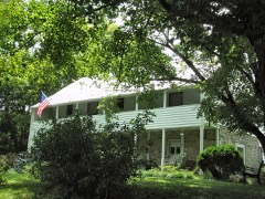 | Amis House | building | 1973 | 73001786 |
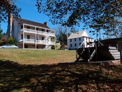 | Boatyard Historic District | district | 1973 | 73001785 |
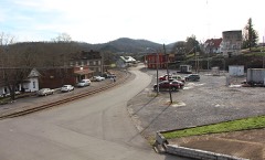 | Bulls Gap Historic District | district | 1987 | 87001232 |
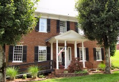 | Fudge Farm | building | 1976 | 76001783 |
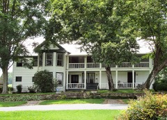 | Long Meadow | building | 1974 | 74001915 |
| Moore Family Farm | district | 2006 | 06000343 | |
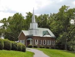 | New Providence Presbyterian Church, Academy, and Cemetery | building | 1978 | 78002600 |
| Pressmen's Home Historic District | district | 1985 | 85002970 | |
 | Price Public Elementary School | building | 1988 | 88002538 |
 | Rogersville Historic District | district | 1973 | 73001787 |
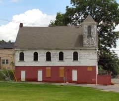 | St. Marks Presbyterian Church | building | 2006 | 06000132 |
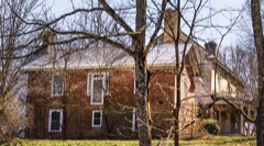 | Stony Point | building | 1973 | 73001788 |
Every wildfire the federal occurrence database records inside this county: 243 of them, burning about 8,713 acres. 7 started naturally and 66 were recorded as arson. Each settlement page carries the fires within five miles of it.
| Reported cause | Fires |
|---|---|
| Debris and open burning | 122 |
| Arson/incendiarism | 66 |
| Missing data/not specified/undetermined | 28 |
| Natural | 7 |
| Smoking | 5 |
| Equipment and vehicle use | 5 |
| Power generation/transmission/distribution | 4 |
| Recreation and ceremony | 3 |
| Other causes | 2 |
| Fireworks | 1 |
The five largest, by the area the report gives. Three of them were set deliberately.
| Date | Cause | Size | Reported by | Name on the report |
|---|---|---|---|---|
| 15 November 2012 | Missing data/not specified/undetermined | 2,185 acres | Tennessee Division of Forestry | SHORT MTN FIRE |
| 15 March 2014 | Debris and open burning | 405 acres | Tennessee Division of Forestry | POOR VALLEY |
| 18 November 2016 | Arson/incendiarism | 306 acres | Tennessee Division of Forestry | DAVY CROCKETT |
| 8 November 2016 | Arson/incendiarism | 294 acres | Tennessee Division of Forestry | MOUTAIN VIEW |
| 9 March 2006 | Debris and open burning | 293 acres | Tennessee Division of Forestry | not named |
| 30 April 2007 | Debris and open burning | 269 acres | Tennessee Division of Forestry | GRASSY CREEK FIRE |
| 27 March 2014 | Debris and open burning | 257 acres | Tennessee Division of Forestry | GRASSY CREEK |
| 16 March 2006 | Arson/incendiarism | 254 acres | Tennessee Division of Forestry | not named |
Every settlement page carries the fires within five miles of it - see the settlement index below.
The NOAA Storm Events Database holds 319 reports for this county, causing 2 deaths, 7 injuries and about $26,061,100 in recorded property damage. Each settlement page carries the reports that name it.
| Kind of event | Reports |
|---|---|
| Thunderstorm Wind | 229 |
| Hail | 50 |
| Flash Flood | 19 |
| Flood | 15 |
| Tornado | 3 |
| Debris Flow | 2 |
| Lightning | 1 |
The most serious of them, by death, then injury, then recorded damage. The accounts are quoted exactly as the forecast office filed them.
| When | Event | Place named | Harm | What the report says |
|---|---|---|---|---|
| February 2019 | Debris Flow | Eidson | 1 killed, $8,720,000 | Wet antecedent soils, with additional rain prior to and during the event. Portion of Hwy 70 collapsed near Cave Springs Road. Two vehicles involved, with one death and one injury. |
| March 2021 | Flood | Surgoinsville | 1 killed, $5,000 | Vehicle attempted to drive through floodwaters of Big Creek near the intersection of Housewright Hollow Road and Hickman Hollow Road. Vehicle was swept into Big Creek. One fatality. |
| March 1955 | Tornado (F2) | not stated | 6 hurt, $250,000 | no account filed |
| June 1994 | Thunderstorm Wind | Rogersville | 1 hurt, $500,000 | A store had its roof damaged. One person was injured as their mobile home was flipped over. Five mobile homes were damaged or destroyed. Two barns were damaged and several trees were blown down. Montgomery County Clarksville,20,2030CST,,,0,0,2,0,Thunderstorm Winds A few trees were knocked down. |
| February 2019 | Debris Flow | Altonville | $15,200,000 | A landslide occurred on Hwy 66 between New Life Road and Clinch Valley Road on the 20th, and another near the same area occurred on the 24th. There was significant damage to Hwy 66. |
| March 2021 | Flash Flood | Mt Carmel | $200,000 | Multiple roads were flooded and some were washed out across the county. Streams were out of their banks and flooding yards. Damages across the county were mainly to roads, and were estimated at $200,000 for the event. |
| October 2010 | Thunderstorm Wind | Rogersville | $40,000 | Emergency management personnel reported multiple trees downed by thunderstorm winds and several mobile homes damaged across the county. |
| July 2006 | Thunderstorm Wind | Church Hill | $30,000 | no account filed |
| September 2006 | Thunderstorm Wind | Bulls Gap | $30,000 | no account filed |
| May 2004 | Tornado (F1) | Johnson Store | $30,000 | no account filed |
| May 2005 | Thunderstorm Wind | Countywide | $25,000 | no account filed |
| May 2002 | Thunderstorm Wind | Countywide | $25,000 | no account filed |
| November 2002 | Thunderstorm Wind | Church Hill | $25,000 | no account filed |
| June 1996 | Thunderstorm Wind | South Part | $25,000 | no account filed |
| June 2009 | Thunderstorm Wind | Rogersville | $20,000 | The newspaper reported numerous trees and powerlines downed by thunderstorm winds countywide. |
| May 2006 | Thunderstorm Wind | Rogersville | $20,000 | no account filed |
| May 2006 | Thunderstorm Wind | Church Hill | $20,000 | no account filed |
| July 2006 | Thunderstorm Wind | Mooresburg | $20,000 | no account filed |
| May 2004 | Thunderstorm Wind | Rogersville | $20,000 | no account filed |
| July 2004 | Thunderstorm Wind | Countywide | $20,000 | no account filed |
| June 2003 | Thunderstorm Wind | Mooresburg | $20,000 | no account filed |
| July 2002 | Thunderstorm Wind | Rogersville | $20,000 | no account filed |
| June 2005 | Thunderstorm Wind | Rogersville | $18,000 | Several trees and powerlines down countywide. |
| May 2006 | Thunderstorm Wind | Church Hill | $18,000 | no account filed |
| May 2004 | Thunderstorm Wind | Mooresburg | $18,000 | no account filed |
| June 2003 | Thunderstorm Wind | Countywide | $18,000 | no account filed |
| June 2008 | Thunderstorm Wind | Surgoinsville | $15,000 | Power company reported several trees and powerlines downed by thunderstorm winds in and around Surgoinsville. |
| August 2007 | Thunderstorm Wind | Church Hill | $15,000 | The sheriffs office reported numerous trees downed by thunderstorm winds around the Church Hill area. |
| August 2005 | Thunderstorm Wind | Church Hill | $15,000 | Three trees down in Church Hill |
| June 1997 | Thunderstorm Wind | Countywide | $15,000 | Trees and powerlines down throughout county. |
| August 1995 | Thunderstorm Wind | Mt Carmel | $15,000 | Trees down onto a house and powerlines down. |
| May 2006 | Thunderstorm Wind | Church Hill | $15,000 | no account filed |
| May 2004 | Thunderstorm Wind | Rogersville | $15,000 | no account filed |
| May 2004 | Thunderstorm Wind | Rogersville | $15,000 | no account filed |
| May 2004 | Thunderstorm Wind | Rogersville | $15,000 | no account filed |
| September 2003 | Thunderstorm Wind | Van Hill | $15,000 | no account filed |
| May 2002 | Thunderstorm Wind | Rogersville | $15,000 | no account filed |
| July 2002 | Thunderstorm Wind | Countywide | $15,000 | no account filed |
| November 2002 | Thunderstorm Wind | Countywide | $15,000 | no account filed |
| July 1999 | Thunderstorm Wind | Rogersville | $15,000 | no account filed |
| June 1999 | Thunderstorm Wind | Church Hill | $15,000 | no account filed |
| June 1998 | Thunderstorm Wind | Rogersville | $15,000 | no account filed |
| November 1998 | Thunderstorm Wind | Rogersville | $15,000 | no account filed |
| May 1997 | Thunderstorm Wind | Countywide | $15,000 | no account filed |
| June 2010 | Thunderstorm Wind | Surgoinsville | $12,000 | Law enforcement personnel reported numerous trees downed by thunderstorm winds across the northeast portions of the county. |
| April 2006 | Thunderstorm Wind | Countywide | $12,000 | Numerous trees and powerlines down countywide. |
| June 2005 | Thunderstorm Wind | Bulls Gap | $12,000 | A few trees down in the southern half of the county. |
| July 2004 | Thunderstorm Wind | Rogersville | $12,000 | no account filed |
| July 2004 | Thunderstorm Wind | Mooresburg Spgs | $12,000 | no account filed |
| July 2004 | Thunderstorm Wind | Mooresburg | $12,000 | no account filed |
| July 2004 | Thunderstorm Wind | Rogersville | $12,000 | no account filed |
| May 2003 | Thunderstorm Wind | Church Hill | $12,000 | no account filed |
| July 1999 | Thunderstorm Wind | Church Hill | $11,000 | no account filed |
| February 2014 | Thunderstorm Wind | Rogersville | $10,000 | Law enforcement reported sporadic trees downed by thunderstorm wind across the county. |
| June 2014 | Thunderstorm Wind | Rogersville | $10,000 | Law enforcement personnel reported many trees downed by thunderstorms wind countywide. |
| January 2013 | Flood | Rogersville | $10,000 | Numerous roads impassable. Five roads washed out. |
| February 2012 | Thunderstorm Wind | Rogersville | $10,000 | The 911 call center reported several trees downed by thunderstorm wind near Rogersville. |
| February 2009 | Thunderstorm Wind | Stony Pt | $10,000 | Law enforcement personnel reported several trees downed by thunderstorm winds between Surgoinsville and Church Hill. |
| April 2007 | Thunderstorm Wind | Mooresburg | $10,000 | A few trees were reported down in the vicinity of Mooresburg. |
| August 2007 | Thunderstorm Wind | Bulls Gap | $10,000 | Sheriffs dispatch reported several trees downed by thunderstorm winds in Bulls Gap. |
The Survey's mineral resources record lists 32 workings inside this county. 4 still produce and 28 are closed or unrecorded. Each settlement page carries the workings within five miles of it.
| Commodity | Workings |
|---|---|
| Marble, Dimension | 9 |
| Barium-Barite | 6 |
| Zinc | 5 |
| Silica | 4 |
| Stone, Crushed/Broken | 3 |
| Barium-Barite, Calcium | 1 |
| Stone, Crushed/Broken, Limestone, General | 1 |
| Zinc, Iron | 1 |
| Limestone, General | 1 |
| Copper | 1 |
| Calcium | 1 |
The least common of them first, because a county's hundredth gravel pit says nothing its first ten did not.
| Where | Site | Commodity | Status | Recorded |
|---|---|---|---|---|
| Click Ridge Barite Prospect | Barium-Barite, Calcium | Occurrence | Vein | |
| Click Ridge Barite Prospect | Barium-Barite, Calcium | Occurrence | ||
| Mccloud Quarry | Limestone, General | Past Producer | Sedimentary | |
| Rodgersville Plant | Stone, Crushed/Broken, Limestone, General | Producer | Limestone | |
| Shiloh Prospect | Zinc, Iron | Occurrence | 1920 | |
| W.D. Johnson Prospect | Copper | Prospect | ||
| Mccloud Quarry | Stone, Crushed/Broken | Past Producer | ||
| Rodgersville Plant & Quarry | Stone, Crushed/Broken | Producer | ||
| Rogersville Quarry | Stone, Crushed/Broken | Producer | ||
| Flat Gap Sandstone Sample | Silica | Occurrence | Sandstone | |
| Flat Gap Sandstone Sample | Silica | Occurrence | ||
| Hunts Gap Quarry | Silica | Producer | 1961 | |
| Hunts Gap Quarry | Silica | Past Producer | ||
| E. J. Lee | Zinc | Prospect | ||
| E. J. Lee Zinc Prospect | Zinc | Occurrence | Stratabound | |
| Lee Valley | Zinc | Prospect | ||
| Lee Valley Zinc Prospect | Zinc | Occurrence | Stratabound | |
| Shiloh | Zinc | Prospect | 1920 | |
| Caney Valley Barite Mine | Barium-Barite | Past Producer | Barite | |
| Caney Valley Barite Mine | Barium-Barite | Past Producer | Residual | |
| Caney Valley Barite Mine | Barium-Barite | Past Producer | ||
| Caney Valley Barite Prospect | Barium-Barite | Occurrence | Barite | |
| Caney Valley Barite Prospect | Barium-Barite | Occurrence | ||
| Cave Quarry | Marble, Dimension | Past Producer | ||
| Dougherty Quarry | Marble, Dimension | Past Producer | ||
| Evans Quarry | Marble, Dimension | Past Producer | ||
| Fudge Quarry | Marble, Dimension | Past Producer | ||
| Kyle Quarry | Marble, Dimension | Past Producer | ||
| Mcclure Quarry | Marble, Dimension | Past Producer | ||
| Price Quarry | Marble, Dimension | Past Producer | ||
| Stamps Quarry | Marble, Dimension | Past Producer | ||
| Stamps Star Quarry | Marble, Dimension | Past Producer |
Named settlements recorded in the Geographic Names Information System, each with the topographic sheets covering it. Villages, hamlets and abandoned places alike. Each is shown with the nearest named watercourse or landform and the survey quadrangle it falls on.
District 3 · 37873 · On Stanley Creek · Looneys Gap quadrangle
13 sheets, 1894 to 1981
No longer a settlement
District 5 · 37857 · Near Smiths Islands (historical) · Bulls Gap quadrangle
19 sheets, 1883 to 1981
District 1 · 37645 · Near Click Ridge · Church Hill quadrangle
22 sheets, 1894 to 1981
District 7 · 37857 · In Butcher Valley · McCloud quadrangle
18 sheets, 1892 to 1980
No longer a settlement
District 4 · 37857 · On Big Branch · Stony Point quadrangle
18 sheets, 1892 to 1980
No longer a settlement
District 4 · 37642 · On Stony Point Creek · Stony Point quadrangle
18 sheets, 1892 to 1980
District 2 · 37642 · On Alexander Creek · Church Hill quadrangle
22 sheets, 1894 to 1981
District 6 · 37857 · On Fisher Creek Ridge · Looneys Gap quadrangle
13 sheets, 1894 to 1981
District 6 · 37811 · On Galbraith Branch · Russellville quadrangle
19 sheets, 1883 to 1981
District 6 · 37811 · On Galbraith Branch · Russellville quadrangle
19 sheets, 1883 to 1981
District 6 · 37857 · Near Winegar Hollow · Burem quadrangle
21 sheets, 1892 to 1980
No longer a settlement
District 7 · 37857 · Near Smiths Islands (historical) · Camelot quadrangle
18 sheets, 1883 to 1981
District 6 · 37857 · On Fisher Creek · Burem quadrangle
21 sheets, 1892 to 1980
No longer a settlement
District 2 · 37857 · Near Graveyard Hill · Stony Point quadrangle
18 sheets, 1892 to 1980
No longer a settlement
District 3 · 37642 · Near Click Ridge · Church Hill quadrangle
22 sheets, 1894 to 1981
District 6 · 37857 · On Little Poor Valley Creek · Lee Valley quadrangle
18 sheets, 1883 to 1981
District 6 · 37811 · On Red House Branch · Russellville quadrangle
19 sheets, 1883 to 1981
District 4 · 37857 · Near Graveyard Hill · Stony Point quadrangle
18 sheets, 1892 to 1980
District 7 · 37711 · On Walker Branch · Bulls Gap quadrangle
19 sheets, 1883 to 1981
No longer a settlement
District 4 · 37873 · Near Tucker Knob · Stony Point quadrangle
18 sheets, 1892 to 1980
No longer a settlement
District 1 · 37645 · Near Sensabaugh Ridge · Church Hill quadrangle
22 sheets, 1894 to 1981
District 1 · 37645 · On Stanley Valley Creek · Church Hill quadrangle
22 sheets, 1894 to 1981
District 2 · 37642 · Near Goshen Valley · Lovelace quadrangle
18 sheets, 1892 to 1980
District 4 · 37857 · On Washboard Creek · Stony Point quadrangle
18 sheets, 1892 to 1980
District 6 · 37811 · Near Gander Hollow · Russellville quadrangle
19 sheets, 1883 to 1981
District 6 · 37811 · Near Ironworks Ridge · Russellville quadrangle
19 sheets, 1883 to 1981
District 1 · 37645 · Near Sawmill Hollow · Church Hill quadrangle
22 sheets, 1894 to 1981
District 4 · 37857 · On Butcher Valley Creek · Stony Point quadrangle
18 sheets, 1892 to 1980
District 3 · 37873 · On Frozen Branch · Plum Grove quadrangle
15 sheets, 1894 to 1981
No longer a settlement
District 4 · 37873 · Near Miller Island · Stony Point quadrangle
18 sheets, 1892 to 1980
District 1 · 37645 · Near Sawmill Hollow · Church Hill quadrangle
22 sheets, 1894 to 1981
District 6 · 37811 · On Quarry Branch · Russellville quadrangle
19 sheets, 1883 to 1981
No longer a settlement
District 1 · 37660 · On Ripley Branch · Kingsport quadrangle
19 sheets, 1894 to 1981
District 1 · 37660 · Near Rocky Hill · Kingsport quadrangle
19 sheets, 1894 to 1981
District 1 · 37645 · Near Sawmill Hollow · Church Hill quadrangle
22 sheets, 1894 to 1981
District 7 · 37857 · Near Arnotts Island · McCloud quadrangle
18 sheets, 1892 to 1980
No longer a settlement
District 6 · 37811 · On McAllister Branch · Lee Valley quadrangle
18 sheets, 1883 to 1981
District 3 · 37873 · On Collins Branch · Plum Grove quadrangle
15 sheets, 1894 to 1981
No longer a settlement
District 4 · 37873 · Near Bradlys Island · Stony Point quadrangle
18 sheets, 1892 to 1980
District 4 · 37873 · On Surgoinsville Creek · Stony Point quadrangle
18 sheets, 1892 to 1980
District 4 · 37857 · Near Beech Creek Valley · Stony Point quadrangle
18 sheets, 1892 to 1980
District 3 · 37873 · On Fisher Creek · Burem quadrangle
21 sheets, 1892 to 1980
No longer a settlement
District 3 · 37642 · On Stanley Valley Creek · Church Hill quadrangle
22 sheets, 1894 to 1981
District 1 · 37645 · Near Sawmill Hollow · Church Hill quadrangle
22 sheets, 1894 to 1981
The vanished settlements of Hawkins County: the places named above that are no longer on the map.