 Block
From the record
19 National Register listings published here.
Sources: the National Register database, National Park Service
44 topographic sheets cover 47 settlements here, and 19 properties are on the National Register of Historic Places.
19 National Register listings published here.
Sources: the National Register database, National Park Service
Every property in this county listed on the National Register of Historic Places, with the year it was listed and the federal nomination document.
| Photograph | Property | Type | Listed | Reference |
|---|---|---|---|---|
 | Brownsville Carnegie Library | building | 2018 | 100002752 |
| Cedar Grove | building | 1980 | 80003833 | |
| College Hill Historic District | district | 1980 | 80003834 | |
| College Hill Historic District (Boundary Increase) | district | 2015 | 14000447 | |
 | Dancyville United Methodist Church and Cemetery | district | 1991 | 91000224 |
| Dunbar-Carver Historic District | district | 2015 | 14001224 | |
| Esso Filling Station | building | 2024 | 100010103 | |
| Haywood County Farm and Cemetery | district | 2025 | 100011910 | |
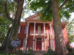 | Joshua K. Hutchison House | building | 1988 | 88001022 |
| Jefferson Street Historic District | district | 2016 | 14001225 | |
| North Washington Historic District | district | 2015 | 14000448 | |
| Republican Primitive Baptist Church | building | 2000 | 00000769 | |
| Stanton Masonic Lodge and School | building | 1987 | 87001878 | |
| Stanton School | building | 2020 | 100005144 | |
 | Temple Adas Israel | building | 1979 | 79002445 |
 | Woodland Baptist Church | building | 2003 | 03000150 |
| Woodlawn Baptist Church | building | 2024 | 100010115 | |
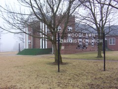 | Woodlawn Baptist Church and Cemetery | building | 1996 | 96001358 |
 | Zion Church | building | 1978 | 78002601 |
Every wildfire the federal occurrence database records inside this county: 38 of them, burning about 602 acres. 1 started naturally and 1 was recorded as arson. Each settlement page carries the fires within five miles of it.
| Reported cause | Fires |
|---|---|
| Debris and open burning | 21 |
| Equipment and vehicle use | 8 |
| Smoking | 4 |
| Railroad operations and maintenance | 1 |
| Natural | 1 |
| Missing data/not specified/undetermined | 1 |
| Arson/incendiarism | 1 |
| Power generation/transmission/distribution | 1 |
The five largest, by the area the report gives. None of them was recorded as arson.
| Date | Cause | Size | Reported by | Name on the report |
|---|---|---|---|---|
| 23 September 2010 | Debris and open burning | 175 acres | Tennessee Division of Forestry | COBB |
| 13 November 2011 | Power generation/transmission/distribution | 55 acres | Tennessee Division of Forestry | BRANTLEY RD. |
| 23 August 2007 | Equipment and vehicle use | 55 acres | Tennessee Division of Forestry | EMERSON HAY FIRE |
| 26 February 1999 | Debris and open burning | 54 acres | Tennessee Division of Forestry | not named |
| 14 January 2000 | Debris and open burning | 38 acres | Tennessee Division of Forestry | not named |
| 1 March 2006 | Debris and open burning | 28 acres | Tennessee Division of Forestry | not named |
| 13 August 1999 | Equipment and vehicle use | 26 acres | Tennessee Division of Forestry | not named |
| 22 August 2007 | Missing data/not specified/undetermined | 25 acres | Tennessee Division of Forestry | FREDONIA TORCH |
Every settlement page carries the fires within five miles of it - see the settlement index below.
The NOAA Storm Events Database holds 184 reports for this county, causing 1 death, 29 injuries and about $6,981,880 in recorded property damage. Each settlement page carries the reports that name it.
| Kind of event | Reports |
|---|---|
| Thunderstorm Wind | 90 |
| Hail | 45 |
| Flash Flood | 25 |
| Tornado | 15 |
| Lightning | 4 |
| Flood | 4 |
| Heavy Rain | 1 |
The most serious of them, by death, then injury, then recorded damage. The accounts are quoted exactly as the forecast office filed them.
| When | Event | Place named | Harm | What the report says |
|---|---|---|---|---|
| January 1988 | Tornado (F2) | not stated | 1 killed, 6 hurt, $250,000 | no account filed |
| March 1953 | Tornado (F2) | not stated | 8 hurt, $25,000 | no account filed |
| April 1953 | Tornado (F1) | not stated | 8 hurt, $25,000 | no account filed |
| January 1999 | Tornado (F3) | Eurekaton | 2 hurt, $100,000 | The tornado started southeast of Eurekaton in Haywood County and travelled northeast crossing into Madison County eventually reaching the north part of the city of Jackson. In Haywood county, seven houses, five mobile homes, five barns and seven sheds were destroyed. In Madison county, the tornado damaged or destroyed several homes in Mercer and Denmark. While moving toward Jackson, the tornado struck the south side of McKellar-Sipes Regional Airport damaging the ASOS equipment located at the airport. The new Tennessee National Guard armory and a hangar were flattened. Two UH-60 helicopters and two other helicopters were destroyed with four additional helicopters damaged. In Jackson, a total of 38 apartments were destroyed. |
| June 1989 | Tornado (F1) | not stated | 2 hurt, $2,500 | no account filed |
| May 2008 | Thunderstorm Wind | Brownsville | 1 hurt, $100,000 | Straight line winds blew trees and power lines down across Brownsville. A few trees were reported down on Highway 76. In addition, trees were reported down near Haywood High School. Trees were also knocked down on numerous houses. One man was injured when a tree fell on his house. A roof was blown off the Dynametal building. |
| November 2001 | Thunderstorm Wind | Hillville | 1 hurt, $50,000 | Several mobile homes were damaged. Several cars were blown around. Some trees and power lines were knocked down. |
| January 2006 | Lightning | Brownsville | 1 hurt | One man was injured by lightning while standing on his porch. |
| May 2010 | Flash Flood | Fredonia | $4,500,000 | Very heavy rain as much as 20 inches fell across Haywood County producing widespread flash flooding. As many as 21 roads were flooded or washed out from the heavy rain. In total, 168 homes sustained some kind of flooding damage. Three businesses received damage as well. Vehicles were stranded in flood waters. At least one flood rescue occurred. The flash flooding event transitioned to a flood event as the heavy rain allowed rivers to rise rapidly overflowing their banks. |
| April 2006 | Tornado (F2) | Brownsville | $400,000 | A F2 intensity tornado briefly touched down in the Hickory Trail subdivision just west of the city of Brownsville. One home was completely destroyed. One home was moved off of its foundation. Twenty-four homes experienced partial roof damage. |
| June 2025 | Flash Flood | Meux Corner | $250,000 | Roadways were flooded throughout the southern part of Haywood County. |
| February 2008 | Tornado (EF2) | Dancyville | $200,000 | A tornado crossed into Haywood County from Fayette County. The tornado produced EF-2 damage in Dancyville. One home was destroyed and another suffered severe damage. A church also had major damage and numerous large trees were uprooted. The tornado continued northeast and caused destruction in Hillville. Two mobile homes were totally destroyed and one house had major damage. A convenience store also suffered roof damage. In addition, an outbuilding was completely flattened and large trees were uprooted or snapped. Several other homes had minor damage along the path. The tornado continued northeast eventually crossing into Madison County. Cleanup costs incurred by Haywood County totaled $168,980. |
| March 2023 | Tornado (EF1) | Eurekaton | $140,000 | A short-lived tornado touched down near Jim Hardister Road in southeast Haywood County on the evening of Friday, March 24, 2023. This tornado primarily uprooted and/or snapped trees, but roof damage was noted to a house, barn, and outbuilding. The tornado continued to a manufactured home, shifting it off the block piers. The last sign of tornado damage occurred just to the northeast at another residence where numerous trees were uprooted and/or snapped, including one that fell onto the residence and caused significant roof damage. The tornado likely lifted up in a field shortly after. Peak winds were estimated at 95 mph. |
| April 2006 | Lightning | Brownsville | $75,000 | Two homes were struck by lightning Thursday morning in Brownsville. One home was located on Sulphur Springs Road and received extensive damage. Another home, located on Poplar Corner Road, suffered at least 50 percent damage due to the lightning strike. There were no injuries. |
| February 1999 | Thunderstorm Wind | Brownsville | $70,000 | A mobile home and a sign for an industrial park were destroyed in Brownsville. A storage trailer was flipped over and three other trailers were damaged in Dancyville. Trees and power lines were blown down in both locations. |
| March 2023 | Tornado (EF1) | St Peters | $50,000 | The tornado that destroyed parts of Covington continued into Haywood County causing significant tree damage along Estes Lane. A mobile home suffered significant damage along Fulton Road. Minor tree damage continued for a few more miles and then the tornado lifted north of Brownsville. Minor damage was observed on Gillespie Road and Highway 54 North with the tornado lifting just east of Sturdivant Road. Peak winds in Haywood County were estimated at around 105 mph. |
| December 2000 | Lightning | Forked Deer | $50,000 | A house was destroyed by a fire started by lightning. |
| April 1999 | Lightning | Brownsville | $50,000 | A home was destroyed by a fire started by lightning. |
| April 2025 | Thunderstorm Wind | Brownsville | $40,000 | A couple homes sustained damage from downed trees. |
| June 1998 | Thunderstorm Wind | Countywide | $40,000 | One house suffered roof damage and the top came off of another building in Brownsville. Several store fronts had windows broken. Some trees were knocked down across the county. |
| January 2023 | Tornado (EF0) | Sunnyhill | $35,000 | A tornado touched down on Shaw Chapel Road four miles south-southwest of Brownsville, TN. Numerous trees sustained damage with broken limbs and a couple of trees were uprooted. The tornado then tracked to the northeast over an open field and began to dissipate as it crossed over Windrow Road. A single-family residence at this location sustained minor shingle damage. No additional damage was noted beyond this point. Peak winds were estimated at 80 mph. |
| June 2018 | Thunderstorm Wind | Nutbush | $30,000 | Trees and power lines were knocked down across the county. |
| March 2017 | Thunderstorm Wind | Oakview | $30,000 | An 80 foot radio mast secured in the ground by cement was blown over and broke in half. In addition a large metal shop door was blown down. |
| March 2023 | Thunderstorm Wind | Eurekaton | $25,000 | The rear flank downdraft of a tornado caused some roof damage to a house on Jim Hardister Road and knocked down trees along Bruce Road. |
| March 2023 | Thunderstorm Wind | Allens | $25,000 | The rear flank downdraft of the tornado that tracked from Tipton County into Haywood County uprooted and snapped trees along Ross Road, Tabernacle Road, and Taylor Cemetery Road. A house suffered roof damage on Sturdivant Road. |
| June 2022 | Tornado (EF0) | Christmasville | $25,000 | A tornado briefly touched down in the Christmasville community in Haywood County. The tornado caused roof damage to the Hickory Grove Missionary Baptist Church. A cemetery next to the church had several small headstones knocked down. One large tree along with several large tree limbs was blown down. |
| May 2003 | Thunderstorm Wind | Brownsville | $25,000 | Sixteen homes had minor damage. Several trees were blown down. One tree fell on a vehicle. |
| September 1996 | Thunderstorm Wind | Brownsville | $25,000 | no account filed |
| April 2025 | Flash Flood | Owl City | $20,000 | Vehicle stranded on Hwy 54 near the Crockett/Haywood County line. Water rescue is underway. |
| July 2023 | Thunderstorm Wind | Stanton | $20,000 | Trees were knocked down across Haywood County. |
| January 1996 | Thunderstorm Wind | Brownsville | $20,000 | no account filed |
| July 2025 | Thunderstorm Wind | Antioch | $15,000 | Trees and power lines were knocked down in the Douglas community. One tree fell on a house. |
| June 2025 | Thunderstorm Wind | Nutbush | $10,000 | Trees were knocked down across northern Haywood County. |
| June 2025 | Thunderstorm Wind | Ko Ko | $10,000 | Trees were knocked down across southern Haywood County. |
| February 2022 | Thunderstorm Wind | Brownsville | $10,000 | A couple of trees were knocked down on Highway 54 North near Brownsville. |
| November 2016 | Thunderstorm Wind | Stanton | $10,000 | Multiple trees down across Highway 70 in Stanton and Highway 76 in Koko. |
| May 2008 | Thunderstorm Wind | Sunnyhill | $10,000 | Straight line winds blew five large trees down near mile marker 54 on Interstate 40. |
| October 2007 | Thunderstorm Wind | Brownsville | $10,000 | Some trees were knocked down in the city of Brownsville. |
| April 2006 | Thunderstorm Wind | Stanton | $10,000 | Trees and power lines were knocked down blocking roadways. |
| June 2003 | Thunderstorm Wind | Brownsville | $10,000 | A barn was damaged. Some trees were blown down. |
| July 1996 | Thunderstorm Wind | Brownsville | $10,000 | no account filed |
| April 2006 | Hail | Brownsville | $7,500 | no account filed |
| June 2023 | Thunderstorm Wind | Stanton | $7,000 | Trees and powerlines were knocked down on Cherry Street in Stanton. |
| February 2008 | Hail | Dancyville | $6,000 | Quarter size hail fell from Dancyville to Exit 60 of Interstate 40, roughly 5 miles southeast of Brownsville. |
| July 2004 | Thunderstorm Wind | Brownsville | $5,000 | A few trees were blown down. |
| August 2004 | Heavy Rain | Brownsville | $5,000 | The awning of a business collapsed due to 3.78 inches of rain that fell in two hours, damaging two vehicles. |
| May 2003 | Thunderstorm Wind | Brownsville | $5,000 | Some trees were knocked down. |
| May 2003 | Thunderstorm Wind | Brownsville | $5,000 | A few trees were blown down across Highway 70. |
| December 2002 | Flash Flood | Brownsville | $5,000 | Some roads were closed due to flooding. |
| November 2002 | Thunderstorm Wind | Belle Eagle | $5,000 | A couple of trees were knocked down. |
| November 2002 | Thunderstorm Wind | Belle Eagle | $5,000 | A few trees were blown down. |
| August 2002 | Thunderstorm Wind | Brownsville | $5,000 | A few trees were knocked down. |
| February 2001 | Thunderstorm Wind | Stanton | $5,000 | Several trees were blown down across Interstate 40. |
| October 2001 | Thunderstorm Wind | Stanton | $5,000 | Some trees were blown down. |
| November 2001 | Thunderstorm Wind | Brownsville | $5,000 | Some trees were blown down. |
| May 2000 | Thunderstorm Wind | Brownsville | $5,000 | Some trees were knocked down. |
| May 1999 | Thunderstorm Wind | Brownsville | $5,000 | Several trees were blown down. |
| March 1998 | Thunderstorm Wind | Brownsville | $5,000 | Some cable and phone lines were knocked down. |
| May 1998 | Thunderstorm Wind | Holly Grove | $5,000 | A few trees were blown down. |
| August 1997 | Thunderstorm Wind | Brownsville | $5,000 | Several trees and power lines were knocked down. |
The Survey's mineral resources record lists 6 workings inside this county. None of them still produces: all are closed or unrecorded. Each settlement page carries the workings within five miles of it.
| Commodity | Workings |
|---|---|
| Clay | 4 |
| Ball Clay | 2 |
The least common of them first, because a county's hundredth gravel pit says nothing its first ten did not.
| Where | Site | Commodity | Status | Recorded |
|---|---|---|---|---|
| Foster & Rawlins Prospect | Ball Clay | Prospect | ||
| Northeast Brownsville Prospect | Ball Clay | Prospect | ||
| Brownsville Prospect | Clay | Past Producer | ||
| Dancyville Prospect | Clay | Occurrence | ||
| Haywood County Farm Prospect | Clay | Past Producer | ||
| South Brownsville Prospect | Clay | Occurrence |
Named settlements recorded in the Geographic Names Information System, each with the topographic sheets covering it. Villages, hamlets and abandoned places alike. Each is shown with the nearest named watercourse or landform and the survey quadrangle it falls on.
District 8 · 38069 · Near Richmond Hill · Dancyville quadrangle
8 sheets, 1952 to 1986
The vanished settlements of Haywood County: the places named above that are no longer on the map.