 Block
From the record
5 National Register listings published here.
Sources: the National Register database, National Park Service
46 topographic sheets cover 62 settlements here, and 5 properties are on the National Register of Historic Places.
5 National Register listings published here.
Sources: the National Register database, National Park Service
Every property in this county listed on the National Register of Historic Places, with the year it was listed and the federal nomination document.
| Photograph | Property | Type | Listed | Reference |
|---|---|---|---|---|
| Doe Creek School | building | 2010 | 10000935 | |
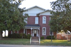 | Thompsie Edwards House | building | 1983 | 83003039 |
| Montgomery High School | building | 2007 | 07000662 | |
| Mount Pisgah Missionary Baptist Church and Cemetery | building | 2014 | 14000942 | |
| Parker's Crossroads Battlefield | site | 1999 | 97001550 |
Every wildfire the federal occurrence database records inside this county: 962 of them, burning about 3,608 acres. 11 started naturally and 193 were recorded as arson. Each settlement page carries the fires within five miles of it.
| Reported cause | Fires |
|---|---|
| Debris and open burning | 497 |
| Arson/incendiarism | 193 |
| Equipment and vehicle use | 99 |
| Missing data/not specified/undetermined | 87 |
| Power generation/transmission/distribution | 23 |
| Misuse of fire by a minor | 14 |
| Smoking | 11 |
| Natural | 11 |
| Recreation and ceremony | 11 |
| Fireworks | 10 |
| Other causes | 4 |
| Railroad operations and maintenance | 2 |
The five largest, by the area the report gives. Four of them were set deliberately.
| Date | Cause | Size | Reported by | Name on the report |
|---|---|---|---|---|
| 4 April 2004 | Missing data/not specified/undetermined | 235 acres | Tennessee Division of Forestry | CHAPEL HILL FIRE |
| 19 August 1999 | Arson/incendiarism | 147 acres | Tennessee Division of Forestry | not named |
| 25 April 2009 | Arson/incendiarism | 131 acres | Tennessee Division of Forestry | RIVER OAK # ONE |
| 28 March 2006 | Debris and open burning | 113 acres | Tennessee Division of Forestry | not named |
| 5 September 2000 | Equipment and vehicle use | 80 acres | Tennessee Division of Forestry | not named |
| 7 September 1998 | Misuse of fire by a minor | 67 acres | Tennessee Division of Forestry | not named |
| 21 November 2010 | Arson/incendiarism | 55 acres | Tennessee Division of Forestry | DYER RD |
| 26 November 2005 | Arson/incendiarism | 54 acres | Tennessee Division of Forestry | not named |
Every settlement page carries the fires within five miles of it - see the settlement index below.
The NOAA Storm Events Database holds 307 reports for this county, causing 15 deaths, 139 injuries and about $31,112,430 in recorded property damage. Each settlement page carries the reports that name it.
| Kind of event | Reports |
|---|---|
| Thunderstorm Wind | 143 |
| Hail | 106 |
| Flash Flood | 25 |
| Tornado | 23 |
| Lightning | 4 |
| Flood | 4 |
| Heavy Rain | 2 |
The most serious of them, by death, then injury, then recorded damage. The accounts are quoted exactly as the forecast office filed them.
| When | Event | Place named | Harm | What the report says |
|---|---|---|---|---|
| March 1952 | Tornado (F4) | not stated | 11 killed, 43 hurt, $2,500,000 | no account filed |
| April 1956 | Tornado (F4) | not stated | 3 killed, 60 hurt, $2,500,000 | no account filed |
| January 1999 | Thunderstorm Wind | Blue Goose | 1 killed, 4 hurt, $2,600,000 | The same thunderstorm complex that produced a tornado in Madison county continued to move northeast and produced downburst winds over parts of Henderson county. One person was killed and several buildings were destroyed south of Blue Goose. Nine houses, 26 mobile homes and 22 other structures were destroyed. Another 134 houses, 61 mobile homes and 52 farm structures were damaged. |
| May 2003 | Tornado (F4) | Luray | 20 hurt, $10,000,000 | The same tornado that produced substantial damage to the city of Jackson continued into Henderson county and moved through the city of Lexington. Thirty-six homes were destroyed and nearly 1,000 homes were damaged. Seven commercial buildings were destroyed and another 73 were damaged including the Everett Horn Library. |
| January 2013 | Thunderstorm Wind | Middle Fork | 3 hurt | Straight line winds of 70 to 80 mph caused widespread damage across Southern Henderson County. Areas of enhanced damage was caused by thunderstorm winds estimated up to 110 mph. About 250 homes were damaged and several of them were destroyed. Numerous other structures were damaged. Numerous trees and power lines were knocked down. Three injuries were reported including one person that broke his hip. |
| March 1953 | Tornado (F2) | not stated | 2 hurt, $25,000 | no account filed |
| April 1991 | Thunderstorm Wind | not stated | 2 hurt | no account filed |
| December 2021 | Tornado (EF2) | Sand Ridge | 1 hurt, $4,000,000 | The tornado began just southwest of US-412 off Pine Crest Drive where several trees were damaged. The tornado crossed US-412 and destroyed an outbuilding then moved northeast towards Highway 104 and damaged the roof of a home. It continued to move northeast across northern Beech Lake and produced more damage in the Timberlake community. A couple of metal power poles were bent and a couple of metal buildings were significantly damaged or destroyed in an industrial park. The most significant damage occurred just east of this area where two TVA transmission towers were completely destroyed. The tornado then continued traveling northeast into Natchez Trace State Park snapping and de-barking numerous trees along its path. One injury was reported in the area of Timberlake Wildersville Road. Peak winds were estimated to be 135 mph. |
| June 2000 | Thunderstorm Wind | Reagan | 1 hurt, $30,000 | A vacant mobile home, a barn and a metal shed were all destroyed. Debris from the destroyed barn damaged the roof of a nearby house. Numerous trees and power lines were also blown down. |
| April 1953 | Tornado (F1) | not stated | 1 hurt, $25,000 | no account filed |
| August 2020 | Lightning | Law | 1 hurt | A lightning strike occurred near the NIDEC plant in northeast Lexington. One injury resulted. |
| June 2011 | Thunderstorm Wind | Independence | 1 hurt | Straight line winds produced minor roof damage to a home along Independence Loop near Independence. A tree fell onto a home in Lexington injuring an occupant. Additional trees and power lines were also knocked down in Lexington. A few homes sustained minor roof damage and a metal storage shed was blown off its foundation as well. |
| May 2010 | Flash Flood | Luray | $5,000,000 | Very heavy rain up to 20 inches produced widespread flooding in Henderson County. Numerous roads and bridges were flooded or washed out. At least 35 culverts were washed out from the heavy rain. As many as 43 homes sustained damage from the flood waters. Numerous rescues from homes and vehicles stranded in flood waters had to be made. The flash flood event transitioned to a flood event by late in the afternoon as heavy rain allowed rivers to overflow their banks. |
| May 1999 | Thunderstorm Wind | Lexington | $1,000,000 | Over 300 homes and businesses were damaged or destroyed in and around the city of Lexington. Some trees were blown down. |
| April 2011 | Thunderstorm Wind | Lexington | $676,000 | Straight line winds caused considerable damage to six houses and six mobile homes across Henderson County. One business and seven farm buildings were also damaged. |
| October 2019 | Thunderstorm Wind | Sardis | $670,000 | Numerous trees and power lines were knocked down throughout the county. Several homes and structures around the county were damaged. |
| June 2013 | Flash Flood | Rock Spgs | $200,000 | Heavy rain produced flash flooding across Northern Henderson County. Numerous roads were flooded as a result including Palmer Road, Holmes Road, Rock Milam Road, Spencer Creek Road and Hamlett Road. One water rescue occurred as a result of the flooding. |
| December 2021 | Tornado (EF1) | Luray | $150,000 | The tornado moved from Madison County into Henderson County. Damage was observed on Crucifer Road where a shed was destroyed and a home damaged. The tornado came to an end between Crucifer and Wilson Roads. Peak winds were estimated to be 95 mph in Henderson County. |
| March 2021 | Tornado (EF1) | Middle Fork | $100,000 | The tornado developed near the Chester/Henderson County line. The first observed damage was uprooted trees along Mifflin Road. The tornado moved east, and crossed Boss Wadley Road. Trees were uprooted, and some trunks were snapped in this area. The most significant damage occurred near Highway 22A and Middlefork Road. A home lost part of its roof, several storage buildings were damaged or destroyed, and a tree fell on another home damaging its roof. Last observed damage occurred east of Highway 22A. This tornado was broad and relatively disorganized for much of its lifetime. Peak winds were estimated at 100 mph. |
| May 2010 | Tornado (EF0) | Cedar Grove | $100,000 | A tornado touched down along Old Reagan Road, southwest of Scotts Hill and tracked northeast. This storm cell had previously produced tornadoes in McNairy and Hardin Counties. A building and outbuilding sustained roof damage at the beginning of the track. The tornado continued northeast and hit Scotts Hill before crossing into Decatur County. Several trees were knocked down along the path. In total, five homes were damaged from the tornado. |
| November 1996 | Thunderstorm Wind | Wildersville | $100,000 | no account filed |
| March 1995 | Tornado (F0) | Lexington | $80,000 | A small tornado touched down destroying a newly built house. |
| March 2021 | Flash Flood | Union Cross | $75,000 | Twenty-two residents were rescued from near flooded homes on Hidden Valley Circle in Lexington. Eight roads were closed around the county due to washed-out culverts. |
| May 2024 | Thunderstorm Wind | Juno | $60,000 | Two barns lost their roofs. One barn was on Poplar Springs Bargerton Road and the other barn was on Poplar Springs Juno Road. |
| March 2025 | Flash Flood | Lexington Arpt | $50,000 | Flash flooding was reported across Lexington. Several roads were washed out. |
| May 2017 | Thunderstorm Wind | Bargerton | $50,000 | Trees and power lines down across central and northern sections of Henderson County. |
| January 2012 | Tornado (EF1) | Center Hill | $50,000 | The tornado started about 5 miles south of Lexington and moved northeast. Numerous trees were uprooted or snapped along the path. A portion of a roof was blown off a house. A shed in the backyard was also destroyed. The tornado touched down primarily on ridge tops before eventually lifting just northeast of Butterscotch Road. |
| July 2009 | Tornado (EF1) | Chapel Hill | $50,000 | A tornado touched down near Mills Darden Road. The tornado moved northeast and lifted near Old Jackson Road. A few outbuildings were damaged or destroyed along the path. Multiple trees and power lines were knocked down as well. A mobile home was moved from the foundation into a power pole. |
| May 2025 | Thunderstorm Wind | Life | $45,000 | An entire roof was blown off from an unknown location. The roof was found lying across Hwy 200 near Broadway Rd South. Trees were also downed in the Lexington area. |
| April 2006 | Tornado (F1) | Sardis | $40,000 | The tornado began near Pitts Road and traveled three and a half miles east to Sardis Cemetery. The tornado lifted as it passed east of the cemetery. Extensive tree and power pole damage was observed along the path, especially at the Sardis Cemetery. Some of the downed trees caused damage to some tombstones in the cemetery. No residences were damaged and there were no injuries. |
| June 2019 | Thunderstorm Wind | Sand Ridge | $30,000 | Several trees down across Henderson County. |
| July 2016 | Flash Flood | Timber Lake | $30,000 | Stanfill Road was completely washed out due to flash flooding. |
| September 2012 | Lightning | Lexington | $30,000 | Lightning struck the Henderson County Criminal Justice Complex causing extensive damage to the fire alarm system, electronic key system, National Crime Information Center records system and the 911 system. |
| June 2008 | Flash Flood | Reagan | $30,000 | Heavy rain produced flash flooding near Reagan. State Highway 100 and several secondary roads were closed with up to a foot of water covering them. Some of the roads were damaged as a result of the flooding. |
| August 2003 | Thunderstorm Wind | Countywide | $30,000 | A preschool center had its roof blown off. Some trees were knocked down across the county. A car was demolished by a fallen tree. |
| July 2020 | Flash Flood | Middle Fork | $25,000 | Part of the road in the 800 block of Simmons Road caved in. The road was closed to all traffic. |
| July 2009 | Tornado (EF0) | Wildersville | $25,000 | A tornado briefly touched down near Webb Road in Wildersville. Shingles were blown off a church roof. Significant structural damage occurred to a shed on the church property. Several tree limbs in the area were knocked down and one power pole was broken. |
| May 2003 | Tornado (F3) | Luray | $25,000 | This tornado moved east from Madison County into Henderson county. Some homes were damaged. |
| November 2002 | Thunderstorm Wind | Mt Gilead | $25,000 | A couple of homes had their roofs blown off. Some trees and power lines were knocked down. |
| May 2001 | Thunderstorm Wind | Middleburg | $25,000 | Thirty homes near Middleburg suffered minor damage. Numerous trees and power lines were knocked down. |
| June 1998 | Thunderstorm Wind | Huron | $25,000 | The roof was blown off a double wide trailer. A nearby storage building and pool were badly damaged. Another trailer was blown over. Several trees had their tops twisted off. |
| November 1996 | Thunderstorm Wind | Huron | $25,000 | no account filed |
| June 1981 | Tornado (F1) | not stated | $25,000 | no account filed |
| April 1957 | Tornado (F2) | not stated | $25,000 | no account filed |
| May 1999 | Thunderstorm Wind | Lexington | $20,000 | A few structures were damaged trapping people in two homes. Numerous trees and power lines were blown down. |
| July 2023 | Thunderstorm Wind | Lexington | $15,000 | Power poles were knocked down on South Broad Street. |
| July 2023 | Thunderstorm Wind | Alberton | $15,000 | Several trees and power poles were knocked down near Natchez Trace Road and Alberton Road. |
| February 2018 | Flood | Chapel Hill | $15,000 | Heavy rain resulted in the flooding of several roads in Henderson County. A culvert was washed out on Piney Creek Road. |
| April 2011 | Tornado (EF0) | Bargerton | $15,000 | A weak tornado touched down near Holmes Road in Henderson County and traveled northeast towards Wildersville. Numerous trees and power lines were knocked down. One home sustained roof damage and one storage shed was destroyed. The tornado continued northeast out of Wildersville and crossed into Carroll County. |
| July 1998 | Thunderstorm Wind | Juno | $15,000 | Some buildings were damaged. A few trees were knocked down. |
| June 1997 | Thunderstorm Wind | Lexington | $15,000 | A huge oak tree, estimated to be 150 years old, was blown down and crushed a car. |
| March 2021 | Tornado (EF0) | Center Hill | $10,000 | A brief tornado uprooted trees along Highway 104 northwest of Reagan. |
| March 2017 | Tornado (EF0) | Center Hill | $10,000 | Mainly tree damage was observed and one house had some tin roofing pulled up. Peak winds estimated at 65 mph. |
| July 2016 | Thunderstorm Wind | Rock Spgs | $10,000 | A few large trees down on Rock Springs Road and Houston Road across the county. |
| July 2003 | Thunderstorm Wind | Lexington | $10,000 | Some trees and power lines were knocked down. |
| July 2003 | Thunderstorm Wind | Reagan | $10,000 | Numerous trees were blown down. |
| March 2002 | Flash Flood | Lexington | $10,000 | Several bridges were washed out. Some roads were flooded. |
| February 2001 | Thunderstorm Wind | Countywide | $10,000 | Some trees were knocked down across the county. |
| July 2001 | Thunderstorm Wind | Countywide | $10,000 | Numerous trees were blown down. |
| May 2000 | Thunderstorm Wind | Lexington | $10,000 | Some trees and power lines were knocked down. One tree fell on a truck. |
The Survey's mineral resources record lists 70 workings inside this county. 23 still produce and 47 are closed or unrecorded. Each settlement page carries the workings within five miles of it.
| Commodity | Workings |
|---|---|
| Sand and Gravel, Construction | 34 |
| Clay | 23 |
| Silica | 10 |
| Fire Clay (Refractory) | 2 |
| Titanium, Metal | 1 |
| Kyanite, Zirconium, Thorium | 1 |
The least common of them first, because a county's hundredth gravel pit says nothing its first ten did not.
| Where | Site | Commodity | Status | Recorded |
|---|---|---|---|---|
| Lexington Placer | Titanium, Metal, Kyanite, Zirconium, Thorium | Producer | Ilmenite, Kyanite, Monazite, Rutile, Zircon | |
| J.N. Scott Property Prospect | Fire Clay (Refractory) | Prospect | ||
| Shade Azbill Hill Prospect | Fire Clay (Refractory) | Prospect | ||
| #39 Mcpeake Pit | Silica | Producer | Unconsolidated Sediments | |
| Eason Pit | Silica | Producer | Unconsolidated Sediments | |
| Holland Pit | Silica | Producer | Unconsolidated Sediments | |
| Jowers Pit | Silica | Producer | Unconsolidated Sediments | |
| Mcpeake #1 Pit | Silica | Producer | Unconsolidated Sediments | |
| Mcpeake #14 Pit | Silica | Producer | Unconsolidated Sediments | |
| Middleton Pit | Silica | Producer | Unconsolidated Sediments | |
| Sorrels & Snow Pit | Silica | Producer | Unconsolidated Sediments | |
| Veteto Pit | Silica | Producer | Unconsolidated Sediments | |
| Weatherly Pit | Silica | Producer | Unconsolidated Sediments | |
| A.W. Holmes Farm Prospect | Clay | Occurrence | ||
| B.F. Anderson Prospect | Clay | Prospect | ||
| Bargerton Prospect | Clay | Occurrence | ||
| Blue Goose Store Prospect | Clay | Occurrence | ||
| Chesterfield Prospect | Clay | Occurrence | ||
| County Line Prospect | Clay | Occurrence | ||
| County Line Prospect | Clay | Occurrence | ||
| Darden Prospect | Clay | Prospect | ||
| E.E. Wilkins Prospect | Clay | Prospect | ||
| East Blue Goose Store Prospect | Clay | Occurrence | ||
| East Lexington Prospect | Clay | Occurrence | ||
| East Lexington Prospect | Clay | Occurrence | ||
| G.W. Robbins Prospect | Clay | Occurrence | ||
| Juno Prospect | Clay | Occurrence | ||
| Law Prospect | Clay | Occurrence | ||
| Lexington Prospect | Clay | Occurrence | ||
| Mcclanahan Pit | Clay | Past Producer | ||
| Mrs. G.M. Douglass Prospect | Clay | Occurrence | ||
| Reagan Prospect | Clay | Occurrence | ||
| Scott Hill Prospect | Clay | Occurrence | ||
| Scotts Hill Prospect | Clay | Occurrence | ||
| West Lexington Prospect | Clay | Occurrence | ||
| Wildersville Prospect | Clay | Occurrence | ||
| Ayers Mineral Div., Central Silica | Sand and Gravel, Construction | Producer | ||
| Eason Pit | Sand and Gravel, Construction | Producer | ||
| Holland Pit | Sand and Gravel, Construction | Past Producer | Sedimentary | |
| Holland Pit | Sand and Gravel, Construction | Producer | ||
| Jowers Pit | Sand and Gravel, Construction | Past Producer | Sedimentary | |
| Jowers Pit | Sand and Gravel, Construction | Producer | ||
| Mcpeake Number 1 Pit | Sand and Gravel, Construction | Past Producer | Sedimentary | |
| Mcpeake Number 1 Pit | Sand and Gravel, Construction | Producer | ||
| Mcpeake Number 14 Pit | Sand and Gravel, Construction | Past Producer | Sedimentary | |
| Mcpeake Number 14 Pit | Sand and Gravel, Construction | Producer | ||
| Middleton Pit | Sand and Gravel, Construction | Past Producer | Sedimentary | |
| Number 39 Mcpeake Pit | Sand and Gravel, Construction | Past Producer | Sedimentary | |
| Number 39 Mcpeake Pit | Sand and Gravel, Construction | Producer | ||
| Sand Pit | Sand and Gravel, Construction | Past Producer | ||
| Sand Pit | Sand and Gravel, Construction | Past Producer | ||
| Sand Pit | Sand and Gravel, Construction | Past Producer | ||
| Sand Pit | Sand and Gravel, Construction | Past Producer | ||
| Sand Pit | Sand and Gravel, Construction | Past Producer | ||
| Sand Pit | Sand and Gravel, Construction | Past Producer | ||
| Sand Pit | Sand and Gravel, Construction | Past Producer | ||
| Sand Pit | Sand and Gravel, Construction | Past Producer | ||
| Sand Pit | Sand and Gravel, Construction | Past Producer | ||
| Sand Pit | Sand and Gravel, Construction | Past Producer | ||
| Sand Pit | Sand and Gravel, Construction | Past Producer | ||
| Sand Pit | Sand and Gravel, Construction | Past Producer | ||
| Sorrels and Snow Pit | Sand and Gravel, Construction | Past Producer | Sedimentary | |
| Sorrels and Snow Pit | Sand and Gravel, Construction | Producer | ||
| Veteto Pit | Sand and Gravel, Construction | Past Producer | Sedimentary | |
| Veteto Pit | Sand and Gravel, Construction | Producer | ||
| Weatherly Pit | Sand and Gravel, Construction | Past Producer | Sedimentary | |
| Weatherly Pit | Sand and Gravel, Construction | Producer | ||
| Wood Pit | Sand and Gravel, Construction | Producer | Unconsolidated Sediments | |
| Wood Pit | Sand and Gravel, Construction | Past Producer | Sedimentary | |
| Wood Pit | Sand and Gravel, Construction | Producer |
Named settlements recorded in the Geographic Names Information System, each with the topographic sheets covering it. Villages, hamlets and abandoned places alike. Each is shown with the nearest named watercourse or landform and the survey quadrangle it falls on.
District 1 · 38321 · On Meals Creek · Juno quadrangle
7 sheets, 1955 to 1986
No longer a settlement
District 3 · 38328 · On Shell Fork · Parsons quadrangle
8 sheets, 1936 to 1986
No longer a settlement
District 1 · 38388 · On Sandy Hollow Branch · Yuma quadrangle
9 sheets, 1936 to 1986
No longer a settlement
District 5 · 38351 · On Little Wolf Creek · Lexington quadrangle
9 sheets, 1936 to 1986
District 1 · 38321 · On Susan Branch · Cedar Grove quadrangle
7 sheets, 1956 to 1986
No longer a settlement
District 3 · 38388 · On North Fork Cub Creek · Yuma quadrangle
9 sheets, 1936 to 1986
No longer a settlement
District 3 · 38363 · On Greasy Creek · Parsons quadrangle
8 sheets, 1936 to 1986
No longer a settlement
District 1 · 38388 · On Scarce Creek · Clarksburg quadrangle
8 sheets, 1936 to 1986
District 3 · 38388 · Yuma quadrangle
9 sheets, 1936 to 1986
No longer a settlement
District 3 · 38388 · On Little Cub Creek · Holladay quadrangle
9 sheets, 1936 to 1986
District 3 · 38388 · On Little Cub Creek · Holladay quadrangle
9 sheets, 1936 to 1986
District 7 · 38374 · On East Fork Cane Creek · Reagan quadrangle
8 sheets, 1936 to 1986
No longer a settlement
District 1 · 38321 · On Cane Creek · Cedar Grove quadrangle
7 sheets, 1956 to 1986
No longer a settlement
The vanished settlements of Henderson County: the places named above that are no longer on the map.