 Block
From the record
3 National Register listings published here.
Sources: the county history on the Internet Archive · the National Register database, National Park Service
60 topographic sheets cover 57 settlements here, and 3 properties are on the National Register of Historic Places.
3 National Register listings published here.
Sources: the county history on the Internet Archive · the National Register database, National Park Service
Every property in this county listed on the National Register of Historic Places, with the year it was listed and the federal nomination document.
| Photograph | Property | Type | Listed | Reference |
|---|---|---|---|---|
| Bon Aqua Springs Historic District | district | 1990 | 90000303 | |
| Primm Springs Historic District | district | 1985 | 85001480 | |
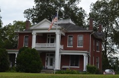 | James Buchanan Walker House | building | 1989 | 89000146 |
Every wildfire the federal occurrence database records inside this county: 786 of them, burning about 5,405 acres. 3 started naturally and 157 were recorded as arson. Each settlement page carries the fires within five miles of it.
| Reported cause | Fires |
|---|---|
| Debris and open burning | 331 |
| Arson/incendiarism | 157 |
| Missing data/not specified/undetermined | 107 |
| Equipment and vehicle use | 73 |
| Smoking | 35 |
| Other causes | 20 |
| Misuse of fire by a minor | 16 |
| Recreation and ceremony | 14 |
| Railroad operations and maintenance | 12 |
| Power generation/transmission/distribution | 11 |
| Fireworks | 7 |
| Natural | 3 |
The five largest, by the area the report gives. Four of them were set deliberately.
| Date | Cause | Size | Reported by | Name on the report |
|---|---|---|---|---|
| 24 November 2016 | Arson/incendiarism | 312 acres | Tennessee Division of Forestry | SIMMONS-SWANN CREEK |
| 25 November 2016 | Arson/incendiarism | 157 acres | Tennessee Division of Forestry | SIMMONS-SWAN CREEK 2 |
| 28 November 2008 | Missing data/not specified/undetermined | 148 acres | Tennessee Division of Forestry | GREASY HOLLOW FIRE |
| 7 February 2009 | Missing data/not specified/undetermined | 118 acres | Tennessee Division of Forestry | GIN BRANCH FIRE |
| 17 November 2016 | Equipment and vehicle use | 113 acres | Tennessee Division of Forestry | DEE O`GUIN RD FIRE |
| 29 April 2001 | Arson/incendiarism | 105 acres | Tennessee Division of Forestry | not named |
| 8 August 2007 | Arson/incendiarism | 104 acres | Tennessee Division of Forestry | OLD MILL CREEK RD |
| 6 April 1998 | Debris and open burning | 100 acres | Tennessee Division of Forestry | not named |
Every settlement page carries the fires within five miles of it - see the settlement index below.
The NOAA Storm Events Database holds 377 reports for this county, causing 5 deaths, 20 injuries and about $10,363,326 in recorded property damage. Each settlement page carries the reports that name it.
| Kind of event | Reports |
|---|---|
| Thunderstorm Wind | 225 |
| Hail | 76 |
| Flash Flood | 35 |
| Tornado | 23 |
| Flood | 10 |
| Lightning | 5 |
| Heavy Rain | 2 |
| Funnel Cloud | 1 |
The most serious of them, by death, then injury, then recorded damage. The accounts are quoted exactly as the forecast office filed them.
| When | Event | Place named | Harm | What the report says |
|---|---|---|---|---|
| March 1952 | Tornado (F2) | not stated | 3 killed, 10 hurt, $25,000 | no account filed |
| May 2010 | Flood | Bon Aqua | 1 killed, $3,600,000 | A women was killed when she stepped off the front porch into water and was swept away. Also, numerous homes, numerous businesses, numerous non comercial buildings, along with several county, state, and federal roads across the county received damage due to the flood. |
| June 2014 | Flash Flood | Only | 1 killed, $20,000 | Several roads were flooded all across Hickman County with numerous road closures. A 6 year old boy drowned on East Beaverdam Road southwest of Centerville when his family tried to drive their vehicle through flood waters from Beaver Dam Creek that had covered the roadway. The vehicle stalled in the high water, with the boy being swept away. Rescue searches did not find the child's body until two days later, where it was discovered three-quarters of a mile downstream. |
| May 2000 | Tornado (F2) | Centerville | 3 hurt, $50,000 | The tornado demolished a home on Mobley Ridge Road, injuring 3 people. Many trees were blown down ...especially on the Natchez Trace Parkway. 33 homes were damaged and 3 barns were destroyed. |
| May 1999 | Thunderstorm Wind | Centerville | 2 hurt, $190,000 | Police department reported 2 mobile homes destroyed, several buildings damaged, and trees and power lines were down. There were 2 injuries. |
| May 2010 | Tornado (EF2) | Coble | 1 hurt, $600,000 | Thousands of hardwood trees were snapped and uprooted along the tornado's 9.15 mile track. Some trees were reduced down to stubs. The tornado was strongest as it crossed highway 50. A brick home suffered considerable structural damage and a woman was injured. Several barns were completely destroyed. The tornado was nearly 1/3 of a mile wide at this point. ||The last evidence of damage was near the intersection of Dodd Hollow and Piney Roads where a few trees were snapped.||Maximum wind speeds in the tornado were estimated to be around 125 mph. |
| February 2008 | Tornado (EF2) | Primm Spgs | 1 hurt, $500,000 | Extensive damage in the Brushy Community. Trees were down, and homes were damaged. One person was injured.||TEMA reported 7 homes were destroyed, and 38 homes had major damage. |
| May 2025 | Thunderstorm Wind | Nunnelly | 1 hurt, $10,000 | Severe thunderstorm winds downed a tree onto a vehicle along SR 48 in Hickman County, Minor injuries to the driver were reported. Damages are a rough estimate. |
| September 2012 | Lightning | Pinewood | 1 hurt, $10,000 | A house was struck by lightning in the Pinewood Community. One male was injured as he was using a computer in the house at the time of the strike and was then transported to an area hospital for treatment. Final condition of this person was unknown. |
| July 1987 | Thunderstorm Wind | not stated | 1 hurt | no account filed |
| May 2020 | Thunderstorm Wind | Lyles | $532,990 | Numerous trees and power lines were blown down across Hickman County including on Pinewood Road, Oak Springs Road, and Highway 100. |
| June 2018 | Tornado (EF1) | Duck River | $500,000 | A very brief yet strong EF-1 tornado formed at the apex of the bowing segment that moved through much of western Middle Tennessee midday on Thursday, June 28th. This brief tornado began northwest of Buck Branch Road knocking down several trees and breaking several large limbs. In addition, roof damage occurred to a home on this road with several outbuildings getting destroyed. As the tornado moved southeast, two homes were struck on Mobley Ridge Road. One house was completely destroyed as the foundation shifted 8-10 ft southeast with the majority of the house falling into the basement. Unfortunately, the house was only metal strapped (and not nailed or bolted/screwed) in a few places to the outer wall. One house occupant survived without injury while trying to get in shelter. The home next door sustained roof damage along with a garage and outbuilding getting destroyed. Eyewitness account stated he saw a skinny rope like tornado touch down in this area. Several more trees were uprooted or had the tops snapped off in this area as well. The tornado continued southeast and weakened, but continued blowing down trees up and down hills along Dunlap Road and Old Trace Road before lifting. The end time and path of this tornado were adjusted and extended southeast by 3/4 of a mile in July 2019 based on newly available high resolution Google Earth satellite imagery, giving a new path length of 2.45 miles. |
| December 2015 | Tornado (EF1) | Farmers Exchange | $500,000 | An EF2 tornado touched down in southern Perry County with estimated maximum sustained winds around 115 mph. Starting along the Buffalo River near the Sugar Hill community four miles south of Linden, the tornado traveled to the east-northeast for 15 miles. Along the path, on Hurricane Creek Road, damage to a brick home was concurrent with winds around 115 mph. Multiple other sheds and barns were destroyed in this same area along with scores of snapped and uprooted hardwood trees. The tornado continued east-northeast and crossed U.S. Highway 412 where a home was totally destroyed. Inside the home, 2 people were fatally injured. Multiple other outbuildings were destroyed along with numerous uprooted hardwood trees. Trees were uprooted along Cane Creek Road. Based on Landsat 8 satellite imagery from NASA Sport, the tornado continued blowing down hundreds of trees for several miles across rural northeast Perry County into southwest Hickman County. The tornado then destroyed a storage shed, damaged several homes, and uprooted and snapped hundreds of trees near the Hornertown community before lifting.||This is the first tornado on record to occur in both Perry County and Hickman County in the month of December. |
| January 2013 | Tornado (EF2) | Coble | $500,000 | An EF2 tornado began southwest of the Coble community then moved northeast along Highway 438, snapping and uprooting hundreds of trees on both sides of the highway. Damage became much more significant in the center of Coble around the intersection of Briar Pond Road and Highway 438. Several brick homes suffered major damage in Coble including one with almost total roof loss and the collapse of a wall. A mobile home was completely destroyed with debris scattered and the metal frame wrapped partially around a tree. A cinder block garage and at least 3 barns were demolished and an RV was flipped on its side. There were no injuries. The tornado then curved eastward and crossed Sulphur Creek Road, Beaverdam Road, and Highway 50, blowing down hundreds of more trees. The tornado lifted just east of Smithfield Road. Aerial and street view imagery from Google Earth greatly assisted with this storm survey. |
| May 2009 | Flash Flood | Pleasantville | $500,000 | More than 20 homes stood with 3 to 4 feet of water in them, and crews had to use boats to rescue several people in the Centerville area. Several roads were flooded along with damage to several bridges, especially in the southern portion of the county.|Sulpher, Coble, Brushy, and Cane Creek communities experienced damage as a result of flash flooding. Totally, six homes were flooded, while 29 had water that spread underneath, though not into living areas. |
| March 2021 | Flash Flood | Nunnelly | $300,000 | Flash flooding washed away portions of Old Mill Creek Road near Nunnelly and destroyed two bridges on Old Hadley School Road near Bon Aqua. |
| June 2025 | Tornado (EF0) | Sunrise | $250,000 | An EF-0 tornado touched down just southeast of Sunrise near Price Road where minor timber damage occurred. The tornado continued east towards Fall Branch Road, doing damage to trees. Mobile home roof damage also occurred and shifted the home off its foundation. The tornado then moved east over a heavily wooded area, crossing over Ugly Creek Road and eventually Blue Buck Creek Road. Here the tornado caused damage to a residence and snapped and uprooted numerous trees before crossing over a ridge top. The tornado weakened thereafter with only tree branches observed on She Boss Road and Old Trace Road. Damages are a rough estimate. |
| October 2014 | Tornado (EF1) | Wrigley | $200,000 | An EF1 tornado max wind speeds of 100 mph touched down in the Hilltop community of northeast Hickman County. Two homes suffered partial roof loss on Highway 100 and another home was knocked off its cinder block foundation on Highway 230. Two garages, a few carports, and several outbuildings were all damaged and destroyed, and an RV was blown over onto its side. Numerous large trees were snapped and uprooted along the upside down V-shaped path. One minor injury resulted from a car striking a tree that fell across highway 230. |
| May 2010 | Tornado (EF2) | Graham Station | $200,000 | Hundreds of hardwood trees were snapped, several barns were destroyed, and a brick home suffered significant roof damage along the tornado's 3.9 mile track. The last evidence of damage was along Keys Branch Road.||Maximum wind speeds in the tornado were estimated to be around 110 mph. |
| February 2019 | Flash Flood | Wrigley | $166,330 | Maury County Emergency Management assisted Hickman County Emergency Management in a water rescue of a woman from a vehicle stranded in Mill Creek near Wrigley. Highway 438 in Coble was also flooded and closed. |
| May 2002 | Thunderstorm Wind | Shipps Bend | $120,000 | Numerous trees were uprooted. Several of these trees were 2 feet in diameter. 12 homes had roof damage mainly from fallen trees. The first damage was noted at a farm on a hilltop just south of Hwy 50 near Shipps Bend. The winds destroyed a barn and carried the tin roof a half a mile away into the trees. 2 grain silos were destroyed, and one of them was ripped from its foundation and carried 35 feet. This occurred on Upper Shipp Road or at about 1/4 mile north of Hwy 50. Debris from the silo was found 1.3 miles to the northeast at the county fair pavilion. Newspaper article described that the Meriwether Lewis Electric Cooperative crews spent hours replacing poles that were snapped in two by the force of the wind, across from Oakmont Cemetery. In the Defeated Community, on Puckett Hollow, fallen trees destroyed a 1979 Ford 4X4. Also, at Beacon Light Estates, which is located off Hwy 100 in Bon Aqua, a house had roof and siding damage on Hill Circle. |
| February 2011 | Thunderstorm Wind | Centerville | $100,000 | The Farmers CO-OP roof was damaged. Minor structure damage included gutters torn off of several homes. Several trees in the area were also blown down. |
| March 1997 | Flash Flood | Countywide | $100,000 | Widespread flooding around county. 2 bridges were washed out and a few roads had high water over them near Pinewood. |
| April 1997 | Lightning | Centerville | $100,000 | Lightning caused a fire that destroyed 2 sawmill buildings at Freeman's Wood Products, Inc. |
| May 2025 | Thunderstorm Wind | Wrigley | $50,000 | A NWS storm survey team determined that damage in Hickman County south of Mill Creek and in the Dogwood Flat area was caused by straight-line winds with estimated winds up to 75 mph. Damage included multiple downed trees and tree branches. Damages are a rough estimate. |
| December 2021 | Tornado (EF1) | Spot | $50,000 | This tornado touched down in far northwest Hickman County east of Spencer Hollow Road and moved northeast across Pewitt Hollow Road, Berryman Hollow Road, I-40 near Old Salt Lick Road, and Old Beaver Creek Road before ending west of Garners Creek Road. The track of this tornado was determined using high resolution NASA satellite imagery. Numerous trees were uprooted along the path which closed I-40 for many hours. No structure damage was reported in this very rural area. Based on newly available high resolution satellite imagery, this tornado was upgraded to EF-1 in March 2023 due to the large number of trees blown down, and the path adjusted, widened and extended to the west by 1 mile. |
| May 2010 | Flash Flood | Spot | $50,000 | Boat rescues occurred as of 10 AM along Interstate 40 between mile marker 153 and 154 as more than five inches of rain had fallen over this particular area. |
| August 2009 | Thunderstorm Wind | Centerville | $50,000 | A portion of the roof was removed causing significant damage inside the Dale's Superstyles Building in Centerville. This is a three story building, with an apartment on the third level. A piece of flashing ended up on the north side of Centerville Square, which is next to this building. It was also raining at this time, with water raining down into a bedroom, two bathrooms and a hallway, as well as on the ceiling tile. It also damaged the back room and the ceiling of the second floor hair salon. Water damage reached as far as the basement of the building, where a local business operates. Winds were estimated as high as 70 MPH. |
| July 1996 | Lightning | Centerville | $50,000 | no account filed |
| September 2009 | Flash Flood | Wrigley | $40,000 | Hickman County Sheriff's Department reported that two cars stalled out due to heavy rainfall that caused Mill Creek to overflow it banks onto Johnny Crow Road. Two women, both driving different cars, as they tried to get out of their cars and escape the fast moving water, were swept downstream, with one of the women being swept as much as one mile downstream. Both women were rescued, taken to local hospitals, and pronounced in good health. CoCoRaHS observer near Bon Aqua reported 3.13 inches of rainfall associated with this storm. |
| April 2010 | Tornado (EF1) | Aetna | $30,000 | A tornado with max winds of 90 mph touched down southwest of the|Aetna community along state highway 48. Damaged continued to the|northeast along state highway 48 for a length of 2 miles and a|maximum width of 100 yards. Hundreds of trees were uprooted and|snapped with a couple of small sheds and trailer destroyed. Some|minor roof damage was noted on a dozen homes. |
| June 2010 | Thunderstorm Wind | Jones Vly | $30,000 | Trees were blown down across the eastern part of county. Wind damage extended into western portions of Maury County. |
| May 2003 | Flash Flood | Countywide | $30,000 | Newpaper related many roads were closed in Hickman county due to high water. |
| April 2026 | Thunderstorm Wind | Centerville | $25,000 | Severe thunderstorm winds downed numerous trees in Hickman County which caused power outages. Roof damage was also reported. Damages are a rough estimate. |
| March 2025 | Tornado (EF0) | Tidwell | $25,000 | An EF-0 tornado touched down just east of Tidwell in far eastern Hickman County. Timber damage occurred near Highway 46 before the tornado progressed into far western Williamson County. Damages are a rough estimate. |
| July 2023 | Thunderstorm Wind | Pinewood | $25,000 | The Hickman County emergency manager reported that numerous trees and powerlines were down across the county due to severe thunderstorm winds. Damages are a rough estimate. |
| December 2021 | Tornado (EF1) | Only | $25,000 | Damage from this tornado started in northern Perry County with some uprooted trees and damage to an outbuilding noted along Crooked Creek Road. A swath of uprooted trees could also be seen on NASA satellite imagery between Crooked Creek Road and Highway 13 across the Walker Hollow and Lott Hollow areas. Continuing northeast, the tornado blew down more trees and damaged outbuildings along Red Bank Road before moving into Humphreys County, where a RV was overturned and roof torn off a barn along Highway 13. The tornado strengthened as it moved through rural forests towards I-40, with thousands of snapped and uprooted trees noted on high resolution satellite imagery near and south of the interstate. Crossing I-40 near mile marker 146 and Barren Hollow Road, the tornado continued blowing down thousands of trees as it pushed northeast. The tornado crossed into far northwest Hickman County and continued to blow down hundreds of trees along Duck River Road and Epperson Hollow Road before lifting west of Spence Hollow Road. Total path length of this tornado was around 15.16 miles. Based on newly available high resolution satellite imagery in March 2023, this tornado was upgraded to EF-2 due to the extreme tree damage between Highway 13 and I-40, and the path length and width were also increased. |
| June 2014 | Thunderstorm Wind | Centerville | $25,000 | Significant wind damage was reported in Centerville with other wind damage all across Hickman County. A hotel and a tobacco store in Centerville suffered roof damage and many other buildings with sheet metal roofs were also damaged. Some billboards were blown down as were several road signs and a flag pole. Numerous trees and power lines were blown down all across the county. |
| April 2011 | Thunderstorm Wind | Nunnelly | $25,000 | Near Nunnelly, storage building on State Highway 100 received roof damage. Trees were also snapped and power lines were downed. Specific details concerning type of roof damage and associated costs were unknown. |
| October 2010 | Thunderstorm Wind | Twomey | $25,000 | Power lines were downed on Columbia Avenue. This caused power outages across the city of Centerville. |
| June 2010 | Thunderstorm Wind | Wrigley | $25,000 | Numerous trees were blown down in the northeastern portion of the county. |
| December 2009 | Thunderstorm Wind | Centerville | $25,000 | Eight hundred Meriwether Lewis Electric Cooperative members had power knocked out beginning at 5:00 PM CST and lasting in some cases until 9:00 AM CST on December 25th as the result of downed trees and power poles. This included a broken power pole in the Pretty Creek area. Also, a transformer that needed repair because of the wind damage was hard to get to becomes several trees had been knocked down, and a bulldozer had to be called in to clear access to it. Residents in Leatherwood, Bucksnort, Pinewood, and Beaverdam communities also were affected. |
| March 2017 | Thunderstorm Wind | Pinewood | $20,000 | A damage survey conducted by Hickman County Emergency Management along with reports from the media and public indicated an approximately 300 yard wide swath of wind damage occurred from north of Nunelly along Highway 230 eastward about 6 miles to southwest of Lyles. TDOT reported 2 trees were blown down on Highway 48. Twenty large trees were snapped and uprooted at the Ginny Linnell farm on Pinewood Mansion Road. Around 12 more trees were snapped and uprooted at the Hickory Winds Farm on Hensley Way. A mobile home on the northeast corner of Hensley Way at Industrial Park Road suffered roof damage, an adjacent garage lost part of its roof, debris was scattered through adjacent fields. Another mobile home further east on Pinewood Lake Drive had a small tree fall onto it. A carport was knocked over at a home on Industrial Park Drive just north of Pinewood Lake Drive, and more roof damage occurred to a home across the street. Numerous more trees were snapped and uprooted around both of these homes. Damage was also reported just to the east on Bates Crossing Road. Although uncertain, convergent patterns in some of the damage photos along with radar data suggests this may have been an EF0 tornado. |
| January 2008 | Thunderstorm Wind | Centerville | $20,000 | A tree fell on a house producing major damage. |
| May 2001 | Tornado (F1) | Bon Aqua | $20,000 | Most of the destruction was on Bee Branch Road. A mobile home was destroyed. It sat on a ridge located at 10095 Bee Br. Rd. The storm also destroyed an empty trailer. The trailer was used as a work area. 2 barns were destroyed. A calf was hurled 100 yards, and a white deck chair was carried a quarter of a mile from the property of Mr. and Mrs. Buchanon on Bee Branch Road. |
| May 1999 | Thunderstorm Wind | North Portion | $20,000 | EMA reported 2 trailers destroyed on Mill Creek Road in the northern part of the county. |
| May 2025 | Thunderstorm Wind | Pinewood | $15,000 | Severe thunderstorm winds downed a tree onto a home on Keys Branch Road near Bon Aqua. Damages are a rough estimate. |
| November 2018 | Tornado (EF0) | Chartersville | $15,000 | This EF-0 tornado touched down just east of the Natchez Trace Parkway in an open field in extreme eastern Hickman County, then moved northeast where trees were damaged and uprooted along two fence lines. Several 2000 pound hay bales were rolled and stacked along one fence line. The tornado continued northeast across the Duck River and into Maury County briefly before moving back into Hickman County, where it crossed Highway 50 and peeled tin off of the front porch of a house. In addition, a large magnolia tree was uprooted along with several hardwood and softwood trees at the residence. The tornado then crossed the Natchez Trace Parkway again, knocking down numerous trees in farm fields before lifting in a field next to Johnson Branch. The total path length was 2.1 miles. |
| January 2012 | Thunderstorm Wind | Shipps Bend | $15,000 | Several trees and power lines were downed across the county. |
| May 2010 | Tornado (EF1) | Cedar Grove | $15,000 | A short lived EF1 Tornado, with maximum winds of 100 MPH, touchdown in Hickman County three tenths of a mile north of the intersection of Ben Fly Road and Beech Valley Road. Path length was 2.73 miles, with a width of 50 yards. Numerous hard wood trees were uprooted and snapped. |
| March 2006 | Thunderstorm Wind | Bon Aqua | $15,000 | 10 mobile homes were pushed off their foundation. Some trees were uprooted. It occurred at Old County Line Road and Highway 46. |
| August 2023 | Thunderstorm Wind | Wrigley | $10,000 | Severe thunderstorm winds uprooted a large tree and downed powerlines on McFarlin Road near Bon Aqua. Damages are a rough estimate. |
| April 2022 | Thunderstorm Wind | Twomey | $10,000 | The roof was damaged and front porch destroyed on a home on Huddleston Road. |
| December 2021 | Tornado (EF0) | Pinewood | $10,000 | This strong EF-2 tornado began in extreme northern Hickman County south of I-40, then tracked northeast across Plunders Creek Road and Brambling Springs Road where it blew down numerous trees. The tornado crossed I-40 near mile marker 166 along Piney Road where it snapped and uprooted dozens of trees on N Mount Sinai Road. The most intense damage occurred on Murrell Drive where multiple homes were heavily damaged or destroyed as they shifted off of their foundations, experienced extensive roof damage, or had exterior walls collapse. In addition to the structural damage, hundreds of trees were snapped or uprooted in the same area. The tornado continued northeast damaging trees on Lena Road, and causing roof damage to homes on Stephen Street and Ridgecrest Drive. The storm crossed Highway 46, damaging the roof and exterior of the Renaissance Center and snapping electric poles along Printwood Drive. It weakened from that point, damaging multiple trees before dissipating just south of downtown Burns. The track of this tornado was extended using high resolution NASA satellite imagery, with a total path length of 10.87 miles. |
| June 2019 | Thunderstorm Wind | Centerville | $10,000 | Trees were blown down across Hickman County. |
| August 2019 | Thunderstorm Wind | Bond | $10,000 | Numerous trees and power lines were blown down across eastern Hickman County, including on Highway 50 East, Swan Creek Road, Ugly Creek Road, Falls Branch Road, Blue Buck Road, 9 Mile Ridge Road, Edgewood Road, and others. |
| June 2018 | Thunderstorm Wind | Centerville | $10,000 | Numerous trees and power lines were blown down all across Hickman County with widespread power outages. |
| June 2018 | Thunderstorm Wind | Tottys Bend | $10,000 | MLEC reported power poles were snapped with power lines down in the Totty's Bend and Gray's Bend areas. |
| November 2018 | Tornado (EF0) | Bond | $10,000 | This EF-0 tornado touched down in forested areas west of the intersection of Swan Creek Road at Short Branch Road and moved northeast. The tornado destroyed a barn on Swan Creek Road and uprooted several trees as it continued east-northeast. Several hardwood and softwood trees were uprooted and two barns had sections of tin blown off on Totty Hollow Lane, but a mobile home at the same location received no damage. A few more trees were uprooted along Bond Road and Blue Buck Road before the tornado lifted north of Blue Buck Creek Road. The damage summary, beginning and ending location and times, and path length of this tornado were updated in July 2019 based on newly available high resolution satellite imagery in Google Earth. |
| November 2018 | Tornado (EF0) | Chartersville | $10,000 | This EF-0 tornado touched down just east of the Natchez Trace Parkway in an open field in extreme eastern Hickman County, then moved northeast where trees were damaged and uprooted along two fence lines. Several 2000 pound hay bales were rolled and stacked along one fence line. The tornado continued northeast across the Duck River and into Maury County briefly before moving back into Hickman County, where it crossed Highway 50 and peeled tin off of the front porch of a house. In addition, a large magnolia tree was uprooted along with several hardwood and softwood trees at the residence. The tornado then crossed the Natchez Trace Parkway again, knocking down numerous trees in farm fields before lifting in a field next to Johnson Branch. The total path length was 2.1 miles. |
The Survey's mineral resources record lists 165 workings inside this county. 7 still produce and 158 are closed or unrecorded. Each settlement page carries the workings within five miles of it.
| Commodity | Workings |
|---|---|
| Phosphorus-Phosphates | 129 |
| Iron | 31 |
| Nickel, Cobalt | 1 |
| Cobalt, Manganese | 1 |
| Cobalt, Manganese, Nickel | 1 |
| Stone, Crushed/Broken | 1 |
| Nickel, Cobalt, Copper, Manganese | 1 |
The least common of them first, because a county's hundredth gravel pit says nothing its first ten did not.
| Where | Site | Commodity | Status | Recorded |
|---|---|---|---|---|
| Bates Farm Prospect | Cobalt, Manganese | Occurrence | 1905 | |
| Chessor Mine | Cobalt, Manganese, Nickel | Past Producer | 1905 | |
| Nunnelly | Nickel, Cobalt | Occurrence | ||
| Nunnelly Prospect | Nickel, Cobalt, Copper, Manganese | Occurrence | 1905 | |
| Wrigley Quarry | Stone, Crushed/Broken | Past Producer | ||
| Aetna Mines | Iron | Past Producer | ||
| Big Spring Creek Mine | Iron | Past Producer | ||
| Booker Prospect | Iron | Prospect | ||
| Brown and Nunnelly Prospect | Iron | Prospect | ||
| Easley Mines | Iron | Past Producer | ||
| Jenkins Branch Mine | Iron | Past Producer | ||
| Jenkins Hollow Prospect | Iron | Past Producer | ||
| Johnson Mines | Iron | Past Producer | ||
| Lee Prospect | Iron | Past Producer | ||
| Milam Prospect | Iron | Past Producer | ||
| Nunnelly Mines | Iron | Past Producer | ||
| Nunnelly Prospect | Iron | Prospect | ||
| Nunnelly Prospects | Iron | Prospect | ||
| Nunnelly-Blackwell Mine | Iron | Past Producer | ||
| Pinewood Prospects North | Iron | Prospect | ||
| Pinewood Prospects South | Iron | Prospect | ||
| Piney Branch Mine | Iron | Past Producer | ||
| Red River Mines | Iron | Past Producer | ||
| Slayden-Richardson Prospect | Iron | Prospect | ||
| Unnamed Prospect | Iron | Prospect | ||
| Unnamed Prospect | Iron | Unknown | ||
| Unnamed Prospect | Iron | Prospect | ||
| Unnamed Prospect | Iron | Prospect | ||
| Unnamed Prospects | Iron | Prospect | ||
| Unnamed Prospects | Iron | Prospect | ||
| W.S. Nunnelly Prospect | Iron | Prospect | ||
| Walker Mine | Iron | Past Producer | ||
| Ward Tunnels | Iron | Past Producer | ||
| Washer Hollow Mine | Iron | Past Producer | ||
| Worley Prospect | Iron | Past Producer | ||
| Wrigley Furnace Mines | Iron | Past Producer | ||
| A.E. Prince Tract | Phosphorus-Phosphates | Prospect | ||
| Alec George Tract | Phosphorus-Phosphates | Past Producer | ||
| Alice Land-J.D. Aydelotte Tract | Phosphorus-Phosphates | Prospect | ||
| Anderson Tract | Phosphorus-Phosphates | Prospect | ||
| Anderson and Rosson Tracts | Phosphorus-Phosphates | Prospect | ||
| Andrew Peery Tract | Phosphorus-Phosphates | Past Producer | ||
| Armour Fertilizer Works Mine | Phosphorus-Phosphates | Past Producer | ||
| Armour's Tenn Chem Co Tract | Phosphorus-Phosphates | Past Producer | ||
| Baker Mine | Phosphorus-Phosphates | Past Producer | ||
| Baker Mine | Phosphorus-Phosphates | Past Producer | ||
| Boyles | Phosphorus-Phosphates | Prospect | ||
| Chamberlain Tract | Phosphorus-Phosphates | Prospect | ||
| Chavers | Phosphorus-Phosphates | Prospect | ||
| Cline | Phosphorus-Phosphates | Prospect | ||
| Crawford Heirs Tract | Phosphorus-Phosphates | Prospect | ||
| Dr. Cooper Tract | Phosphorus-Phosphates | Prospect | ||
| Ford George Tract | Phosphorus-Phosphates | Past Producer | ||
| George Hutchison Tract | Phosphorus-Phosphates | Prospect | ||
| George W. Hutchison Heirs Property | Phosphorus-Phosphates | Prospect | ||
| Greer | Phosphorus-Phosphates | Prospect | ||
| Grimmett & Mrs. Burns Tracts | Phosphorus-Phosphates | Prospect | ||
| Hannah Long Tract | Phosphorus-Phosphates | Prospect | ||
| Harrison Cole Brothers Property | Phosphorus-Phosphates | Occurrence | ||
| Harville Tract | Phosphorus-Phosphates | Prospect | ||
| Haw Branch Tract | Phosphorus-Phosphates | Past Producer | ||
| Hickman County Mine #2 | Phosphorus-Phosphates | Producer | 1938 | |
| Hickman County Mines | Phosphorus-Phosphates | Past Producer | ||
| Hickman County Mines | Phosphorus-Phosphates | Past Producer | ||
| Hickman County--Williamsport | Phosphorus-Phosphates | Producer | ||
| Hill Mccaleb and W.D. Totty Tracts | Phosphorus-Phosphates | Past Producer | ||
| Hooker #519 Cummins #1 | Phosphorus-Phosphates | Producer | 1974 | |
| Hooker #521 Cummins | Phosphorus-Phosphates | Producer | 1974 | |
| Hooker #523 Totty | Phosphorus-Phosphates | Producer | 1972 | |
| Hooker #526 B. C. Baker | Phosphorus-Phosphates | Past Producer | 1975 | |
| Hooker #529 Fielder | Phosphorus-Phosphates | Past Producer | 1968 | |
| Hooker #530 J.R.Anderson | Phosphorus-Phosphates | Producer | 1972 | |
| Hooker #536 Harville #1 | Phosphorus-Phosphates | Past Producer | 1974 | |
| Hooker #537 Nichols | Phosphorus-Phosphates | Past Producer | 1973 | |
| Hooker 522 | Phosphorus-Phosphates | Past Producer | ||
| Hooker 522 | Phosphorus-Phosphates | Past Producer | ||
| Hooker 522 | Phosphorus-Phosphates | Past Producer | ||
| Hooker 523 | Phosphorus-Phosphates | Past Producer | ||
| Hooker 523 | Phosphorus-Phosphates | Past Producer | ||
| Hooker 524 | Phosphorus-Phosphates | Past Producer | ||
| Hooker 524 | Phosphorus-Phosphates | Past Producer | ||
| Hooker 527 | Phosphorus-Phosphates | Past Producer | ||
| Hooker 527 | Phosphorus-Phosphates | Past Producer | ||
| Hooker 529 | Phosphorus-Phosphates | Past Producer | ||
| Hooker 529 Pit | Phosphorus-Phosphates | Past Producer | ||
| Hooker 530 | Phosphorus-Phosphates | Past Producer | ||
| Hooker 530 | Phosphorus-Phosphates | Past Producer | ||
| Hooker 539 | Phosphorus-Phosphates | Past Producer | ||
| Hooker 539 | Phosphorus-Phosphates | Past Producer | ||
| Hooker 539 | Phosphorus-Phosphates | Past Producer | ||
| Hooker Chemical Company No.1 | Phosphorus-Phosphates | Unknown | ||
| Hooker Chemical Company No.2 | Phosphorus-Phosphates | Unknown | ||
| Hooker Chemical No.3 | Phosphorus-Phosphates | Unknown | ||
| Hughes Tract | Phosphorus-Phosphates | Prospect | ||
| J.A. Grimes Tract | Phosphorus-Phosphates | Prospect | ||
| J.A. Hutchison Tract | Phosphorus-Phosphates | Prospect | ||
| J.B. Walker Tract | Phosphorus-Phosphates | Past Producer | ||
| J.M. Anderson Tract | Phosphorus-Phosphates | Past Producer | ||
| J.P. Grimes Tract | Phosphorus-Phosphates | Prospect | ||
| J.R. Bates Tract | Phosphorus-Phosphates | Past Producer | ||
| James Anderson Tract | Phosphorus-Phosphates | Prospect | ||
| Jarecki Tracts | Phosphorus-Phosphates | Past Producer | ||
| L.S. Simmons Place | Phosphorus-Phosphates | Past Producer | ||
| L.W. Aydelotie Property | Phosphorus-Phosphates | Prospect | ||
| Lester Fly | Phosphorus-Phosphates | Prospect | ||
| Littlelot Mine | Phosphorus-Phosphates | Plant | ||
| M C West Cs-32 Pit | Phosphorus-Phosphates | Past Producer | ||
| M. C. West Ne-1 Pit | Phosphorus-Phosphates | Prospect | ||
| M. C. West Sw-16 Pit | Phosphorus-Phosphates | Past Producer | ||
| M. C. West Sw-26 Pit | Phosphorus-Phosphates | Past Producer | ||
| M.C. West Cs-32 | Phosphorus-Phosphates | Past Producer | ||
| M.C. West Ne-1 | Phosphorus-Phosphates | Past Producer | ||
| M.C. West Sw-16 | Phosphorus-Phosphates | Past Producer | ||
| M.C. West Sw-26 | Phosphorus-Phosphates | Past Producer | ||
| M.C.West Phosphate Deposit No 1 | Phosphorus-Phosphates | Unknown | ||
| M.C.West Phosphate Deposit No.3 | Phosphorus-Phosphates | Unknown | ||
| M.M. and J.P. Mccaleb Tract | Phosphorus-Phosphates | Past Producer | ||
| M.P. Aydelotte Tract | Phosphorus-Phosphates | Prospect | ||
| Maury Co. Blue Phosphate Co Tract | Phosphorus-Phosphates | Prospect | ||
| Mcgill Tract | Phosphorus-Phosphates | Past Producer | ||
| Mcgill and Cunningham Tract | Phosphorus-Phosphates | Prospect | ||
| Meridian Fertilizer Factory Tract | Phosphorus-Phosphates | Past Producer | ||
| Monsanto Phosphate Deposit No. 40 | Phosphorus-Phosphates | Unknown | ||
| Monsanto Phosphate Deposit No.35 | Phosphorus-Phosphates | Unknown | ||
| Monsanto Phosphate Deposit No.36 | Phosphorus-Phosphates | Unknown | ||
| Monsanto Phosphate Deposit No.37 | Phosphorus-Phosphates | Unknown | ||
| Monsanto Phosphate Deposit No.38 | Phosphorus-Phosphates | Unknown | ||
| Monsanto Phosphate Deposit No.39 | Phosphorus-Phosphates | Unknown | ||
| Monsanto Phosphate Deposit No.41 | Phosphorus-Phosphates | Unknown | ||
| Monsanto Phosphate Deposit No.42 | Phosphorus-Phosphates | Unknown | ||
| Monsanto Phosphate No.34 | Phosphorus-Phosphates | Unknown | ||
| Mrs. Fred Hillsman Property | Phosphorus-Phosphates | Past Producer | ||
| N.Y. & St. Louis M. & M. Co. Tracts | Phosphorus-Phosphates | Prospect | ||
| N.Y. St. Louis M. & M. Co. Tract | Phosphorus-Phosphates | Occurrence | ||
| New York & St. Louis Mining Co Mine | Phosphorus-Phosphates | Past Producer | ||
| New York & St. Louis Mining Co Prop | Phosphorus-Phosphates | Prospect | ||
| Nixon Tract | Phosphorus-Phosphates | Prospect | ||
| Nunn No. 1 Tract | Phosphorus-Phosphates | Prospect | ||
| Nunn No. 2 Tract | Phosphorus-Phosphates | Past Producer | ||
| O.A. Prince Property | Phosphorus-Phosphates | Past Producer | ||
| O.A. Prince Tract No. 1 | Phosphorus-Phosphates | Prospect | ||
| O.A. Prince Tract No. 2 | Phosphorus-Phosphates | Prospect | ||
| Old Short Heirs Tract | Phosphorus-Phosphates | Past Producer | ||
| Parks Heirs Tract | Phosphorus-Phosphates | Prospect | ||
| Peery Survey Tract | Phosphorus-Phosphates | Prospect | ||
| Peery Tracts | Phosphorus-Phosphates | Prospect | ||
| Primm | Phosphorus-Phosphates | Prospect | ||
| R.C. Connor Property | Phosphorus-Phosphates | Prospect | ||
| R.I. Nixon Tract | Phosphorus-Phosphates | Past Producer | ||
| R.W. White Tract | Phosphorus-Phosphates | Prospect | ||
| Roberts Tract | Phosphorus-Phosphates | Prospect | ||
| Shipp and Simmons Tract | Phosphorus-Phosphates | Prospect | ||
| Simmons and Long Tracts | Phosphorus-Phosphates | Prospect | ||
| Smith Tract | Phosphorus-Phosphates | Prospect | ||
| Smithson Tract | Phosphorus-Phosphates | Past Producer | ||
| Stanfill Tract | Phosphorus-Phosphates | Prospect | ||
| Tennessee River Valley Tract | Phosphorus-Phosphates | Prospect | ||
| Unnamed | Phosphorus-Phosphates | Prospect | ||
| Unnamed | Phosphorus-Phosphates | Prospect | ||
| Unnamed | Phosphorus-Phosphates | Prospect | ||
| Upper Rochelle Tract | Phosphorus-Phosphates | Prospect | ||
| W.W. Mcclanahan Tract | Phosphorus-Phosphates | Past Producer | ||
| Watkins Tract | Phosphorus-Phosphates | Prospect | ||
| Whig Mathis Tract | Phosphorus-Phosphates | Prospect | ||
| Whitesides Tract | Phosphorus-Phosphates | Past Producer |
One book written about this county, cut here where the book itself is cut, at its printed chapters: 22 chapters in all. Every chapter is public domain, machine-read from the scan and reproduced complete. A chapter already given under one of the county's towns is not repeated in this list.
| Chapter | Length |
|---|---|
| Chapter 1: Early History of Tennessee | 2,634 words |
| Chapter 2: Some Pioneer History | 5,843 words |
| Chapter 3: Hickman County | 624 words |
| Chapter 4: The First District | 8,887 words |
| Chapter 5: The Second District | 6,981 words |
| Chapter 6: The Third District | 10,379 words |
| Chapter 7: The Fourth District | 3,993 words |
| Chapter 8: The Fifth District | 5,708 words |
| Chapter 9 | 4,530 words |
| Chapter 10: The Seventh District | 7,493 words |
| Chapter 11: The3 Eighth District | 8,037 words |
| Chapter 12: The Ninth District | 4,888 words |
| Chapter 13: The Tenth District | 2,911 words |
| Chapter 14: The Eleventh District | 3,738 words |
| Chapter 15: The Twelfth District | 2,794 words |
| Chapter 16: The Thirteenth District | 2,762 words |
| Chapter 17: The! Fourteenth District | 3,323 words |
| Chapter 18: The Fifteenth District | 4,245 words |
| Chapter 19: Our Legislators | 14,024 words |
| Chapter 21 | 452 words |
| Chapter 23: Hickman County Soldiers | 2,766 words |
| Chapter 24: Hickman County Confederates | 8,876 words |
Named settlements recorded in the Geographic Names Information System, each with the topographic sheets covering it. Villages, hamlets and abandoned places alike. Each is shown with the nearest named watercourse or landform and the survey quadrangle it falls on.
District 7 · 37033 · Near Staggs Hollow · Beaverdam Springs quadrangle
12 sheets, 1936 to 1986
District 5 · 38476 · Near Sugarcamp Hollow · Littlelot quadrangle
15 sheets, 1901 to 1986
No longer a settlement
District 7 · 37033 · On Peters Branch · Beaverdam Springs quadrangle
12 sheets, 1936 to 1986
District 5 · 38454 · On Stillhouse Branch · Littlelot quadrangle
15 sheets, 1901 to 1986
No longer a settlement
District 5 · 38454 · Near Tinsley Hollow · Greenfield Bend quadrangle
16 sheets, 1901 to 1986
District 7 · 37033 · On Wades Branch · Beaverdam Springs quadrangle
12 sheets, 1936 to 1986
District 6 · 37033 · Near Mount Pillar Ridge · Centerville quadrangle
14 sheets, 1901 to 1986
District 6 · 37033 · Near Harrington Ridge · Centerville quadrangle
14 sheets, 1901 to 1986
District 7 · 37033 · Near McClearen Hollow · Pleasantville quadrangle
12 sheets, 1936 to 1986
District 5 · 38454 · On Betsobe Branch · Littlelot quadrangle
15 sheets, 1901 to 1986
No longer a settlement
District 1 · 37140 · On South Fork Sugar Creek · Bucksnort quadrangle
13 sheets, 1936 to 1986
District 7 · 37033 · Near Goodman Hollow · Beaverdam Springs quadrangle
12 sheets, 1936 to 1986
District 5 · 38487 · Near Stillhouse Hollow · Primm Springs quadrangle
16 sheets, 1901 to 1986
District 5 · 38476 · On Barren Fork · Primm Springs quadrangle
16 sheets, 1901 to 1986
No longer a settlement
District 5 · 37098 · On Cavender Branch · Littlelot quadrangle
15 sheets, 1901 to 1986
District 7 · 38454 · Near York Hollow · Greenfield Bend quadrangle
16 sheets, 1901 to 1986
District 1 · 37137 · Near Boneyard Hollow · Texas Hollow quadrangle
16 sheets, 1901 to 1986
District 7 · 37033 · On Upper Sinking Creek · Pleasantville quadrangle
12 sheets, 1936 to 1986
District 5 · 38476 · Near Stevens Hollow · Primm Springs quadrangle
15 sheets, 1901 to 1986
District 5 · 38454 · On Irvin Branch · Greenfield Bend quadrangle
16 sheets, 1901 to 1986
District 7 · 37033 · Near Mill Hollow · Pleasantville quadrangle
12 sheets, 1936 to 1986
No longer a settlement
District 6 · 37033 · Near Moss Spring Hollow · Centerville quadrangle
14 sheets, 1901 to 1986
District 7 · 37033 · Near Coble Hollow · Pleasantville quadrangle
12 sheets, 1936 to 1986
District 7 · 37033 · On Little Piney Creek · Centerville quadrangle
14 sheets, 1901 to 1986
The vanished settlements of Hickman County: the places named above that are no longer on the map.