 Block
From the record
8 National Register listings published here.
Sources: the National Register database, National Park Service
59 topographic sheets cover 40 settlements here, and 8 properties are on the National Register of Historic Places.
8 National Register listings published here.
Sources: the National Register database, National Park Service
Every property in this county listed on the National Register of Historic Places, with the year it was listed and the federal nomination document.
| Photograph | Property | Type | Listed | Reference |
|---|---|---|---|---|
| Enochs Mill | building | 1999 | 99001138 | |
| Fort Hill and Butterfield, Archibald D., House | district | 2001 | 01000101 | |
 | Greyhound Half-Way House | building | 1999 | 99001588 |
| Hurricane Mills Rural Historic District | district | 1999 | 99001449 | |
| Johnsonville Historic District | district | 2001 | 01000257 | |
 | Hugh M. McAdoo House | building | 1991 | 91001595 |
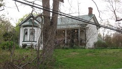 | James N. Nolan House | building | 1986 | 86000395 |
| Sycamore Landing | building | 1980 | 80003837 |
Every wildfire the federal occurrence database records inside this county: 340 of them, burning about 3,838 acres. 3 started naturally and 85 were recorded as arson. Each settlement page carries the fires within five miles of it.
| Reported cause | Fires |
|---|---|
| Debris and open burning | 135 |
| Arson/incendiarism | 85 |
| Missing data/not specified/undetermined | 50 |
| Equipment and vehicle use | 25 |
| Smoking | 16 |
| Railroad operations and maintenance | 13 |
| Power generation/transmission/distribution | 4 |
| Other causes | 3 |
| Natural | 3 |
| Misuse of fire by a minor | 3 |
| Recreation and ceremony | 2 |
| Fireworks | 1 |
The five largest, by the area the report gives. Five of them were set deliberately.
| Date | Cause | Size | Reported by | Name on the report |
|---|---|---|---|---|
| 27 March 1998 | Arson/incendiarism | 331 acres | Tennessee Division of Forestry | not named |
| 22 April 2009 | Arson/incendiarism | 330 acres | Tennessee Division of Forestry | CLEAR CREEK FIRE |
| 2 September 1999 | Arson/incendiarism | 300 acres | Tennessee Division of Forestry | not named |
| 7 March 2010 | Arson/incendiarism | 240 acres | Tennessee Division of Forestry | DANIEL ROAD FIRE |
| 7 March 2000 | Arson/incendiarism | 142 acres | Tennessee Division of Forestry | not named |
| 17 April 2010 | Debris and open burning | 108 acres | Tennessee Division of Forestry | AIRPORT ROAD |
| 6 August 2008 | Debris and open burning | 84 acres | Tennessee Division of Forestry | not named |
| 11 March 2002 | Railroad operations and maintenance | 77 acres | Tennessee Division of Forestry | not named |
Every settlement page carries the fires within five miles of it - see the settlement index below.
The NOAA Storm Events Database holds 264 reports for this county, causing 20 deaths, 3 injuries and about $108,694,740 in recorded property damage. Each settlement page carries the reports that name it.
| Kind of event | Reports |
|---|---|
| Thunderstorm Wind | 146 |
| Hail | 47 |
| Flash Flood | 35 |
| Tornado | 25 |
| Flood | 6 |
| Heavy Rain | 3 |
| Lightning | 2 |
The most serious of them, by death, then injury, then recorded damage. The accounts are quoted exactly as the forecast office filed them.
| When | Event | Place named | Harm | What the report says |
|---|---|---|---|---|
| August 2021 | Flash Flood | Pigeon Roost | 19 killed, $100,000,000 | An historic, devastating flash flood struck the city of Waverly along the Trace Creek river basin. A fast-moving flood wave traveling westward down Trace Creek caused flood waters to rise several feet in roughly a 10 minute timespan between 1000am to 1010am CDT, flooding hundreds of homes, businesses, and churches, some of which were washed off their foundations. News reports and information from the Tennessee Emergency Management Agency indicated a total of 523 homes were impacted by the flooding, with 272 totally destroyed, 168 with major damage, 31 with minor damage, and 20 affected. 44 businesses and 8 public facilities were also damaged, including the Waverly Elementary School and Waverly Junior High School which will have to be torn down are rebuilt in a different location. Dozens of cars were also washed away and deposited long distances downstream, and many of the roadway bridges than spanned Trace Creek were knocked off their pilings and heavily damaged. TEMA reported damage to roads and schools alone totaled $31,844,911, with an additional estimated $60-70 million in damage to homes and businesses. 19 people were killed in Waverly, along with 1 other who died in Hurricane Mills, making this the deadliest flash flood in Middle Tennessee history. |
| August 2021 | Flash Flood | Hurricane Mills | 1 killed | Major flash flooding affected the Hurricane Mills community along Hurricane Creek. Several buildings at the Loretta Lynn Ranch and Campground were flooded and damaged, and the pavement on Hurricane Mills Road was washed away in several locations. A ranch foreman at Loretta Lynn's ranch died while checking on animals in a stable and getting swept away by the rising flood waters. |
| January 1999 | Tornado (F2) | Gorman | 1 hurt, $500,000 | Downed trees were reported from Gorman to McEwen. The hardest hit area was McEwen with 4 homes totally destroyed, 8 homes having severe damage, and 38 homes receiving minor damage. 8 to 10 outbuildings were destroyed and 60 trees were lost. 8 cars or trucks were damaged or destroyed. A man suffered a broken neck in his trailer. |
| November 1996 | Thunderstorm Wind | Mc Ewen | 1 hurt, $50,000 | no account filed |
| July 2012 | Thunderstorm Wind | Sycamore Lndg | 1 hurt, $10,000 | Humphreys Sheriffs Office reported a tree was downed on a trailer with one injury on Cuba Landing Road. Details concerning any damage that occurred to the trailer and the extent of the injury were unknown. |
| October 2019 | Thunderstorm Wind | Sycamore Lndg | $2,410,000 | A 5-10 mile wide swath of severe downburst winds struck the central portions of Humphreys County, roughly from the Tennessee River border area with Perry County northeastward through Hurricane Mills, between Waverly and McEwen, to areas between Highway 13 and Highway 231 along the Houston County border. Dozens of power lines and power poles were blown down and thousands of trees were snapped or uprooted, with some falling on homes mainly in the Cuba Landing and Sycamore Landing areas in southwest Humphreys County. Multiple tractor-trailers were also blown over onto their sides on the I-40 bridge across the Tennessee River. Power outages lasted up to 2 weeks, with most Humphreys County schools closed during this 2 week period. Damage estimates from the Tennessee Emergency Management Agency across Humphreys County reached $2.41 million. Winds were estimated up to 90 mph. |
| May 2010 | Flash Flood | Buffalo | $2,200,000 | Spotter relayed reports of water rescues near the Humphreys and Hickman County line...near mile marker 148 along Interstate 40. Also, numerous homes, numerous businesses, numerous non comercial buildings, along with several county, state, and federal roads across the county received damage due to the flood. |
| August 2003 | Thunderstorm Wind | New Johnsonville | $348,000 | Spotter reported a wall on a building collapsed. EMA Storm Damage Assessment report stated there was damage to roofs, gutters and siding to homes in New Johnsonville to about 55 homes. A few trees fell on homes. Cars and carports were damaged from the strong thunderstorm winds. Numerous roads were closed, and there were downed trees and power lines throughout northwest Humphreys County. Damage assessment was placed at $347,600. |
| April 2025 | Tornado (EF1) | Buffalo | $250,000 | An EF-1 tornado first began near Interstate 40 near Buffalo, snapping and uprooting numerous trees. The tornado continued northeast along Highway 13, causing additional timber damage and damaging Overholt's Farm Market. It is believed to have dissipated in a heavily wooded area east of Highway 13 thereafter. Damages are a rough estimate. |
| March 1997 | Flash Flood | Countywide | $250,000 | no account filed |
| May 1992 | Tornado (F0) | not stated | $250,000 | no account filed |
| January 2013 | Tornado (EF1) | Hurricane Mills | $200,000 | An EF1 tornado began around 1 mile west-southwest of Hurricane Mills and moved eastward before lifting 4 miles east-northeast of town. Approximately 500 trees were snapped or uprooted along the path of the tornado through Hurricane Mills. A barn was also destroyed and several homes and other buildings suffered significant roof damage at the Loretta Lynn Ranch and Campground area. The tornado crossed Highway 13 and continued eastward along Stewart Branch Road, with hundreds more trees snapped and uprooted. The tornado lifted west of Bold Spring Road. Aerial imagery from Google Earth greatly assisted with this storm survey. |
| April 2009 | Tornado (EF1) | Concord | $200,000 | An EF-1 Tornado, with maximum estimated wind speed around 100 mph, did extensive tree damage along Gander Branch Road and destroyed a barn and damaged a nearby house on Tennessee Ridge Road near Concord in Humphreys County. The tornado also damaged a barn and downed trees near Woolworth on Route 13, then lifted northeast of Silvertop in Houston County. The tornado had a path length of 12 miles and a maximum width of 300 yards.||Newspaper reported that emergency management officials stated that three homes and a mobile home received minor damage and hundereds of trees were rooted in Houston County. In Humpreys County, one house appeared to have major damage, one had significant damage, and a double wide mobile home was destroyed. |
| November 2005 | Tornado (F1) | New Johnsonville | $200,000 | Roof damage to several homes was observed from Old State Route 1 and on Long Street. One house and several mobile homes were destroyed. Many other homes had structural damage. A barn on Old State Route 1 lost its roof. As many as 2000 people were without power during the height of the storm. This storm complex moved into Dickson County. |
| April 2011 | Tornado (EF1) | Waverly | $150,000 | Initial damage was noted just west of Waverly near the intersection of Bowen Hills Drive and U.S. Highway 70. The damage continued directly through downtown Waverly for approximately 2.9 miles. The last evidence of damage was near the intersection of Fairfield Drive and U.S. Highway 70. The damage path was very narrow, with a maximum width of only 75 yards.||In addition to dozens of snapped and uprooted trees, several businesses in Waverly suffered significant roof damage. Signs and overhangs were also torn off by the winds, and there were several homes and vehicles crushed by falling trees. |
| March 2025 | Tornado (EF1) | Waverly Arpt | $100,000 | An EF-1 tornado touched down northwest of McEwen in northeast Humphreys County. This tornado began in a wooded area south of E Richland Creek Road, causing timber damage. The tornado impacted a home on Brown Hollow Road, causing roof damage and snapping nearby trees. The tornado then continued east, causing more timber damage on Hatcher Hollow Road, and then dissipated along Smith Road. Damages are a rough estimate. |
| March 2025 | Tornado (EF0) | Hurricane Mills | $100,000 | An EF-0 tornado touched down in southern Humphreys County near Highway 13 and Dyer Road. The tornado caused several areas of timber damage along Dyer Road which led to powerline damage as well as structural damage. The tornado appeared to have ran along the Duck River near the end of its path and is believed to have dissipated near Willhite Road. Damages are a rough estimate. |
| December 2021 | Tornado (EF2) | Pruette Spg | $100,000 | Damage from this tornado started in northern Perry County with some uprooted trees and damage to an outbuilding noted along Crooked Creek Road. A swath of uprooted trees could also be seen on NASA satellite imagery between Crooked Creek Road and Highway 13 across the Walker Hollow and Lott Hollow areas. Continuing northeast, the tornado blew down more trees and damaged outbuildings along Red Bank Road before moving into Humphreys County, where a RV was overturned and roof torn off a barn along Highway 13. The tornado strengthened as it moved through rural forests towards I-40, with thousands of snapped and uprooted trees noted on high resolution satellite imagery near and south of the interstate. Crossing I-40 near mile marker 146 and Barren Hollow Road, the tornado continued blowing down thousands of trees as it pushed northeast. The tornado crossed into far northwest Hickman County and continued to blow down hundreds of trees along Duck River Road and Epperson Hollow Road before lifting west of Spence Hollow Road. Total path length of this tornado was around 15.16 miles. Based on newly available high resolution satellite imagery in March 2023, this tornado was upgraded to EF-2 due to the extreme tree damage between Highway 13 and I-40, and the path length and width were also increased. |
| March 2020 | Tornado (EF1) | Denver | $100,000 | An EF-2 tornado started in Benton County northwest of Camden and caused a substantial amount of tree damage along a path that extended to the Tennessee River. Several homes and mobile homes were alsodamaged, mostly in the Ballard Road area, resulting in 1 death and 2 injuries.||The tornado continued across the Tennessee River into Humphreys County, causing EF-1 damage and blowing downhundreds of trees from the river eastward acrossCrystal Springs Road. Progressing eastward, several dozen more trees were blown downalong Lucas Ridge Road, Hemby Branch Road, and Clydeton Road, with some roof panels also damaged and removed from a small outbuilding on Clydeton Road. Additional trees were uprooted along Brazzle Road and Stephenson Road before the tornado dissipatedaround Highway 13. |
| April 2006 | Tornado (F1) | Hurricane Mills | $100,000 | The storm touched down just south of Carroll Hollow along Cuba Landing Rd. Large trees were snapped, uprooted or blown down. The tornado crossed Bakerville Road where a brick home was 40 percent destroyed. A mobile home was demolished with only a twisted metal frame left at the mobile home's original site. The tornado went across Jack Rudolph Road and lifted up along Old Highway 13 where trees were destroyed and another mobile home was pushed off its foundation. |
| May 2020 | Thunderstorm Wind | Mc Ewen | $71,190 | Several trees were blown down and outbuildings damaged around McEwen. Other trees and power lines were blown down across Humphreys County. |
| February 2021 | Thunderstorm Wind | Plant | $50,000 | A 1/2 mile wide by 1/4 mile long microburst damaged several homes and outbuildings on Mill Road from Wagner Road to Honey Point Ferry Lane on the east side of New Johnsonville. Several trees, power lines, and power poles were also blown down. Winds were estimated up to 75 mph. |
| March 2013 | Tornado (EF1) | Mc Ewen | $50,000 | A high-end EF1 tornado with maximum winds around 105 mph and a path width of 150 yards touched down in northeastern Humphreys County and tracked northeastward before exiting the county at 0642 CST. Outbuildings were damaged on White Oak Road with sheet metal wrapped around trees. Dozens of trees were snapped or uprooted along the track. |
| April 2011 | Thunderstorm Wind | Mc Ewen | $50,000 | A carport was destroyed, several homes suffered minor roof damage, and dozens of trees were snapped and uprooted. Maximum wind speeds were estimated to be between 80 to 90 mph. |
| May 2006 | Thunderstorm Wind | Waverly | $30,000 | Waverly P.D. reported at least a dozen trees were blown down in Waverly. Newspaper article reported damage to cars, homes, and utility buildings. Stop lights were even blown down in the wind gusts. Several cars were damaged by fallen trees at Waverly Junior High School. Trees and an electric line were down at U.S. Highway 70 and Melrose East. Some trees fell on a house in the Cedar Hill section of Waverly. Also, a utility building was lifted off the ground and deposited across a street in Waverly. |
| May 1996 | Thunderstorm Wind | Waverly | $30,000 | no account filed |
| April 2025 | Thunderstorm Wind | Pigeon Roost | $25,000 | Severe thunderstorm winds downed trees on Collier Lane and caused minor damage to one home in far western Humphreys County. Damages are a rough estimate. |
| April 2025 | Thunderstorm Wind | Mc Ewen | $25,000 | Severe thunderstorm winds downed trees and powerlines in McEwen. Damages are a rough estimate. |
| April 2025 | Thunderstorm Wind | Mc Ewen | $25,000 | Severe thunderstorm winds caused minor structural damage to a home on Old Nashville Highway near McEwen. Damages are a rough estimate. |
| April 2025 | Thunderstorm Wind | Buffalo | $25,000 | Severe thunderstorm winds caused structural damage to Overholt's Store just north of Exit 143 off Interstate 40 in Hurricane Mills. Damages are a rough estimate. |
| March 2020 | Tornado (EF0) | Mc Ewen | $25,000 | An EF-0 tornado touched down along Curtis Chapel Road just northwest of McEwen, where it damaged a small barn. The tornado continued eastward and damaged/uprooted some trees along CCC Road as well as caused some minor roof damage to a home. Additional damage was found on Tummins Road where a few trees were uprooted. The tornado appeared to dissipate shortly after that location. |
| May 2012 | Thunderstorm Wind | Waverly | $25,000 | A train track gate was blown down in Waverly. Details concerning which particular train track gate blown down were unknown. Several trees were also downed in Waverly. |
| July 2012 | Thunderstorm Wind | Forest Hill | $25,000 | Humphreys Sheriffs Office reported trees were blown down in several locations in an around Waverly and McEwen. |
| April 2011 | Thunderstorm Wind | Forest Hill | $25,000 | Winds were estimated at between 80 to 85 mph. Trees and power lines were downed across Waverly. |
| May 2011 | Thunderstorm Wind | Mc Ewen | $25,000 | Several trees were downed across the county. |
| May 2010 | Flash Flood | Waverly | $25,000 | At 11:50 AM, storm total rainfall over the last 24 hours was measured as 13.34 inches. This rainfall resulted in flash flooding causing Lomax Avenue in Waverly to become totally covered with water. |
| August 2010 | Thunderstorm Wind | Waverly | $25,000 | Numerous trees and power lines were reported downed along Bakerville Road. |
| June 2010 | Thunderstorm Wind | Denver | $25,000 | Trained spotter estimated 60 mph wind gust occurred near New Johnsonville. Several trees were snapped in the area. Other trees were blown down near Waverly. |
| August 2009 | Thunderstorm Wind | Mc Ewen | $25,000 | Trees were downed in McEwen. |
| August 2009 | Thunderstorm Wind | New Johnsonville | $25,000 | Trees were downed in New Johnsonville. |
| November 1983 | Tornado (F1) | not stated | $25,000 | no account filed |
| June 1981 | Tornado (F0) | not stated | $25,000 | no account filed |
| June 1981 | Tornado (F0) | not stated | $25,000 | no account filed |
| March 1952 | Tornado (F2) | not stated | $25,000 | no account filed |
| April 2025 | Thunderstorm Wind | Poplar Grove | $20,000 | Severe thunderstorm winds downed about fifteen trees and several powerlines over a stretch of about 400 yards, including a tree on a vehicle, along Poplar Grove Road south of McEwen. Damages are a rough estimate. |
| February 2013 | Lightning | Hurricane Mills | $20,000 | Lightning reportedly struck a food building at the Loretta Lynn Ranch in Hurricane Mills, and the resulting fire destroyed the structure. |
| July 2012 | Thunderstorm Wind | Mc Ewen | $20,000 | Several trees were blown down on Trace Creek Road and U.S. Highway 70 in McEwen. |
| April 2008 | Thunderstorm Wind | Hustburg | $20,000 | Several large trees blew down. One tree fell on a house on Arrowhead Dr. |
| October 2014 | Thunderstorm Wind | Waverly | $15,000 | A tree fell onto a home in Waverly causing broken windows and major damage to the roof. |
| July 2012 | Thunderstorm Wind | Waverly | $15,000 | Several trees and power lines were downed in Waverly, resulting in a power outage in the city. |
| April 2010 | Tornado (EF1) | Pruette Spg | $15,000 | The tornado entered Humphreys County just north of the intersection of Blue Creek and Crooked Creek Roads. Damage consisting of snapped and uprooted trees continued almost nine miles northeast crossing Interstate 40 just east of the Highway 13 exit. The last evidence of damage was along Barren Hollow Road just north of I-40. |
| March 2025 | Thunderstorm Wind | Waverly | $10,000 | Severe thunderstorm winds downed and snapped a few trees in the Waverly area along Main Street. Damages are a rough estimate. |
| April 2025 | Thunderstorm Wind | Buffalo | $10,000 | Severe thunderstorm winds downed several trees which blocked Interstate 40 East at mile markers 141 to 143 near Hurricane Mills. Damages are a rough estimate. |
| December 2023 | Thunderstorm Wind | Sycamore Lndg | $10,000 | Strong winds from a supercell snapped trees west of Hurricane Mills near the Tennessee River. Damages are a rough estimate. |
| June 2019 | Thunderstorm Wind | Waverly | $10,000 | Trees and power lines were blown down across Humphreys County with a few roadways blocked. |
| April 2018 | Thunderstorm Wind | Waverly | $10,000 | The majority of a tin roof was removed from a home on North Buchanan Road. |
| June 2018 | Thunderstorm Wind | Mc Ewen | $10,000 | MLEC reported numerous trees and power lines down across Humphreys County, mainly in the McEwen, Hurricane Creek, Poplar Grove, and Cuba Landing areas. |
| July 2017 | Tornado (EF0) | Mc Ewen | $10,000 | A weak EF0 tornado touched down in far northern Humphreys County 4.6 miles northwest of McEwen, then curved northeast and east-northeast before lifting just south of the Houston County line. Damage began on Dry Hollow Road near Mt Zion Road where a shed was overturned and several trees were snapped and uprooted in a convergent pattern, with a few trees falling onto a home. Numerous trees were blown down along Deer Creek Road and Highway 231 eastward past Peach Creek Road. A home lost several shingles, the door was blown off an outbuilding, and more trees were snapped on Tom Brown Road before the tornado lifted east of Smith Branch Road. The end point and path length of this tornado were adjusted slightly in May 2019 based on new satellite imagery available in Google Earth. This is the first tornado on record in Humphreys County in the month of July since official NWS records began in 1950. |
| March 2017 | Thunderstorm Wind | Gorman | $10,000 | Based on reports and photos from a trained spotter along with radar data, a swath of wind damage struck a farm along Enoch Road just south of Little Blue Creek Road, then continued northeast across Little Blue Creek Road. An outbuilding was destroyed and two large farm buildings suffered roof damage, with debris from the buildings blown eastward across Enoch Road. Several trees were also blown down at the farm. Farther to the east, several more trees were blown down along a bend in Little Blue Creek Road. Based on radar data and a slight convergent pattern in the debris, this may have been a brief EF-0 tornado. |
| January 2013 | Flash Flood | Denver | $10,000 | Trailer park was evacuated due to high water near Victory Lane in Waverly. Specific details concerning if any damage occured to the trailer park were unknown. |
The Survey's mineral resources record lists 11 workings inside this county. 7 still produce and 4 are closed or unrecorded. Each settlement page carries the workings within five miles of it.
| Commodity | Workings |
|---|---|
| Iron | 4 |
| Sand and Gravel, Construction | 2 |
| Stone, Crushed/Broken, Limestone, General | 1 |
| Aluminum | 1 |
| Titanium, Pigment | 1 |
| Stone, Crushed/Broken | 1 |
| Manganese | 1 |
| Lithium, Manganese | 1 |
The least common of them first, because a county's hundredth gravel pit says nothing its first ten did not.
| Where | Site | Commodity | Status | Recorded |
|---|---|---|---|---|
| (Facility) New Johnsonville Refinery | Lithium, Manganese | Plant | ||
| Consol Aluminum/New Johnsonville Tn | Aluminum | Plant | ||
| Ledbetter Prospect | Iron, Manganese | Occurrence | ||
| New Johnsonville Plant Ti | Titanium, Pigment | Plant | 1959 | |
| Rock Hill Plant | Stone, Crushed/Broken, Limestone, General | Producer | 1936 | |
| Rock Hill Plant & Quarry | Stone, Crushed/Broken | Producer | ||
| Dredge Iv | Sand and Gravel, Construction | Producer | ||
| Herbert Plant Dredge Operation | Sand and Gravel, Construction | Producer | Unconsolidated Sediments | |
| Franks Prospect | Iron | Past Producer | ||
| Rice Prospect | Iron | Occurrence | ||
| Turner Prospect | Iron | Prospect |
Named settlements recorded in the Geographic Names Information System, each with the topographic sheets covering it. Villages, hamlets and abandoned places alike. Each is shown with the nearest named watercourse or landform and the survey quadrangle it falls on.
District 5 · 37185 · Near Capps Hollow · Hurricane Mills quadrangle
12 sheets, 1936 to 1986
District 5 · 37185 · Near Pierce Hollow · Hurricane Mills quadrangle
12 sheets, 1936 to 1986
District 5 · 37078 · Near Toland Hollow · Hurricane Mills quadrangle
12 sheets, 1936 to 1986
District 1 · 37185 · Near Davidson Hollow · Harmon Creek quadrangle
8 sheets, 1936 to 1985
No longer a settlement
District 5 · 37185 · Near Hutchinson Hollow · Hustburg quadrangle
14 sheets, 1936 to 1986
No longer a settlement
District 7 · 37101 · On Dogwood Branch · Tennessee City quadrangle
8 sheets, 1936 to 1985
District 5 · 37101 · On Little Blue Creek · McEwen quadrangle
8 sheets, 1936 to 1985
District 1 · 37185 · Near Schoolhouse Hollow · Halls Creek quadrangle
8 sheets, 1936 to 1985
District 2 · 37185 · Near Slayden Hollow · Waverly quadrangle
9 sheets, 1936 to 1985
District 5 · 37078 · Near Page Hollow · Hurricane Mills quadrangle
12 sheets, 1936 to 1986
District 4 · 37134 · On Chappell Hollow Branch · Hustburg quadrangle
14 sheets, 1936 to 1986
District 1 · 37134 · Near Meredith Hollow · Johnsonville quadrangle
9 sheets, 1936 to 1985
District 1 · 37134 · Near Spain Hollow · Johnsonville quadrangle
9 sheets, 1936 to 1985
District 1 · 37185 · Near Sectionhouse Hollow · Waverly quadrangle
9 sheets, 1936 to 1985
District 1 · 37185 · Near Racetrack Hollow · Johnsonville quadrangle
9 sheets, 1936 to 1985
No longer a settlement
The vanished settlements of Humphreys County: the places named above that are no longer on the map.