 Block
From the record
13 National Register listings published here.
Sources: the National Register database, National Park Service
104 topographic sheets cover 59 settlements here, and 13 properties are on the National Register of Historic Places.
13 National Register listings published here.
Sources: the National Register database, National Park Service
Every property in this county listed on the National Register of Historic Places, with the year it was listed and the federal nomination document.
| Photograph | Property | Type | Listed | Reference |
|---|---|---|---|---|
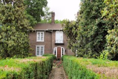 | Branner-Hicks House | building | 1974 | 74001919 |
| Cherokee Hydroelectric Project | district | 2017 | 100001468 | |
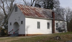 | Christ Temple AME Zion Church | building | 2005 | 05001221 |
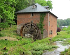 | Cox's Mill | building | 1983 | 83003041 |
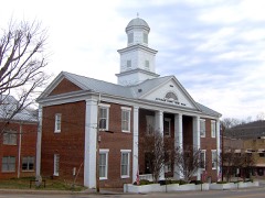 | Dandridge Historic District | district | 1973 | 73001792 |
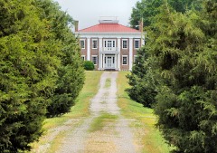 | Fairfax | building | 1973 | 73001795 |
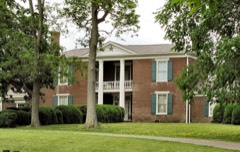 | Fairvue | building | 1982 | 82003978 |
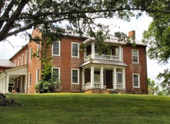 | Lawson D. Franklin House | building | 1973 | 73001796 |
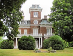 | Glenmore | building | 1973 | 73001794 |
| Hill-Hance House | building | 1982 | 82003977 | |
| Mossy Creek Presbyterian Church | building | 2024 | 100010996 | |
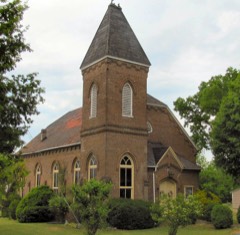 | New Market Presbyterian Church | building | 1998 | 98000823 |
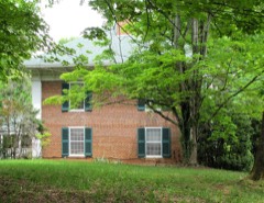 | Squirewood Hall | building | 1973 | 73001793 |
Every wildfire the federal occurrence database records inside this county: 23 of them, burning about 241 acres. None started naturally and 7 were recorded as arson. Each settlement page carries the fires within five miles of it.
| Reported cause | Fires |
|---|---|
| Debris and open burning | 12 |
| Arson/incendiarism | 7 |
| Missing data/not specified/undetermined | 2 |
| Smoking | 1 |
| Other causes | 1 |
The five largest, by the area the report gives. Two of them were set deliberately.
| Date | Cause | Size | Reported by | Name on the report |
|---|---|---|---|---|
| 8 March 2014 | Debris and open burning | 114 acres | Tennessee Division of Forestry | OLD DANDRIDGE PIKE FIRE |
| 1 May 2007 | Arson/incendiarism | 21 acres | Tennessee Division of Forestry | LAKE VIEW FIRE |
| 29 March 2018 | Debris and open burning | 20 acres | Tennessee Division of Forestry | SKYLINE ROAD |
| 3 April 2007 | Debris and open burning | 16 acres | Tennessee Division of Forestry | HORSE LOT FIRE |
| 22 February 2014 | Debris and open burning | 12 acres | Tennessee Division of Forestry | BALES FIRE |
| 1 April 2010 | Missing data/not specified/undetermined | 10 acres | Tennessee Division of Forestry | LOST CREEK |
| 25 March 1997 | Arson/incendiarism | 8.0 acres | Tennessee Division of Forestry | not named |
| 3 March 2007 | Debris and open burning | 5.0 acres | Tennessee Division of Forestry | BIG BEND |
Every settlement page carries the fires within five miles of it - see the settlement index below.
The NOAA Storm Events Database holds 308 reports for this county, causing no deaths, 5 injuries and about $3,986,000 in recorded property damage. Each settlement page carries the reports that name it.
| Kind of event | Reports |
|---|---|
| Thunderstorm Wind | 230 |
| Hail | 51 |
| Tornado | 10 |
| Flash Flood | 7 |
| Lightning | 5 |
| Flood | 4 |
| Funnel Cloud | 1 |
The most serious of them, by death, then injury, then recorded damage. The accounts are quoted exactly as the forecast office filed them.
| When | Event | Place named | Harm | What the report says |
|---|---|---|---|---|
| December 2021 | Thunderstorm Wind | New Market | 2 hurt | Wind damaged a mobile home. A couple was injured and had to be helped from their home. |
| July 2004 | Lightning | Gravelly Hill | 1 hurt | no account filed |
| July 2002 | Lightning | Douglas Lake North | 1 hurt | no account filed |
| July 1989 | Thunderstorm Wind | not stated | 1 hurt | no account filed |
| February 2011 | Flood | Jefferson City | $2,190,000 | Continuous heavy rainfall from thunderstorms caused extensive flooding countywide. 50 homes and five mobile homes in the county suffered minor to major damage due to the flooding. Two local businesses also had minor damage due to the flood waters. |
| October 2001 | Thunderstorm Wind | Countywide | $250,000 | no account filed |
| May 1996 | Thunderstorm Wind | Dumplin | $100,000 | no account filed |
| August 2010 | Lightning | Dandridge | $80,000 | An isolated thunderstorm produced a lightning strike that severely damaged a home. |
| February 1998 | Thunderstorm Wind | Jefferson City | $70,000 | no account filed |
| August 2006 | Lightning | New Market | $60,000 | A two-story garage was struck by lightning on Dairy Farm Road in New Market. The building was destroyed. |
| June 2013 | Tornado (EF1) | Hodges | $50,000 | The NWS storm survey team concluded that an EF1 tornado tracked across Jefferson County on the 13th of June. It formed 4.7 miles northwest of New Market and lifted 3.1 west-northwest of New Market. It had a path length of 2.0 miles and a path width of 120 yards. The max wind of 100 mph snapped and uprooted numerous trees along its damage path, as well as causing roof damage to a home. |
| October 1999 | Thunderstorm Wind | White Pine | $50,000 | no account filed |
| May 1999 | Thunderstorm Wind | White Pine | $50,000 | no account filed |
| August 2010 | Thunderstorm Wind | Dandridge | $25,000 | The public reported numerous trees and powerlines downed by thunderstorm winds near Dandridge. A few structures were also damaged. |
| June 2009 | Thunderstorm Wind | Jefferson City | $25,000 | The newspaper reported numerous trees and powerlines downed by thunderstorm winds in Jefferson City and countywide. A few outbuildings were also damaged by the winds. |
| April 2007 | Thunderstorm Wind | Dandridge | $25,000 | Numerous trees were reported down from White Pine and Dandridge to Chestnut Hill along highway 92. |
| May 2005 | Thunderstorm Wind | Countywide | $25,000 | no account filed |
| May 2000 | Thunderstorm Wind | Countywide | $25,000 | no account filed |
| July 1997 | Tornado (F0) | New Market | $25,000 | no account filed |
| April 1974 | Tornado (F0) | not stated | $25,000 | no account filed |
| April 2011 | Tornado (EF0) | Kansas | $20,000 | A NWS Storm Survey reported an EF0 tornado touched down near White Pine. It formed near Rankin Road then tracked to the southern portions of White Pine where it dissipated. The max wind of 80 mph caused minor roof damage on a few homes and downed several trees. |
| April 2011 | Tornado (EF0) | Jefferson City | $20,000 | A NWS Storm Survey reported an EF0 tornado touched down near Jefferson City. It formed near and caused damage at the American Book Company. It had a path width of 50 yards and a path length of 0.3 miles. The max wind of 80 mph snapped...twisted and downed a few trees along the path. |
| June 2011 | Thunderstorm Wind | Dandridge | $20,000 | Law enforcement personnel reported numerous trees downed by thunderstorm wind across the southern third of the county. |
| August 2010 | Thunderstorm Wind | Dandridge | $20,000 | Law enforcement personnel reported several trees and powerlines downed by thunderstorm winds in the Dandridge area. A few buildings were also damaged. |
| October 2005 | Thunderstorm Wind | Countywide | $20,000 | Several trees and powerlines downed in the Strawberry Plains and New Market areas. |
| November 2002 | Thunderstorm Wind | White Pine | $20,000 | no account filed |
| May 2001 | Thunderstorm Wind | Countywide | $20,000 | no account filed |
| February 2000 | Thunderstorm Wind | Countywide | $20,000 | no account filed |
| July 1999 | Thunderstorm Wind | Countywide | $20,000 | no account filed |
| June 1999 | Thunderstorm Wind | New Market | $18,000 | no account filed |
| April 2015 | Thunderstorm Wind | New Market | $15,000 | Dispatch personnel reported several trees and a some powerlines downed by thunderstorm wind in New Market. Some structural damage was also reported. |
| August 2010 | Thunderstorm Wind | White Pine | $15,000 | Law enforcement personnel reported several trees and powerlines downed by thunderstorm winds in White Pine. |
| June 2009 | Thunderstorm Wind | Chestnut Grove | $15,000 | Law enforcement officials reported a large tree downed by thunderstorm winds on a home north of Dandridge on Old Stage Road. |
| June 2009 | Thunderstorm Wind | Jefferson City | $15,000 | Law enforcement personnel reported several trees downed by thunderstorm winds in Jefferson City. In addition, winds damaged a car parked in Jefferson City after a tree fell on it. |
| June 2008 | Thunderstorm Wind | New Market | $15,000 | Dispatch reported several trees and powerlines downed by thunderstorm winds in and around New Market. |
| June 2007 | Thunderstorm Wind | Jefferson City | $15,000 | Several trees were downed by thunderstorm winds in Jefferson City and the rest of the county. |
| June 2007 | Thunderstorm Wind | Dandridge | $15,000 | Several trees downed by thunderstorm winds countywide. |
| August 2006 | Thunderstorm Wind | Countywide | $15,000 | Numerous trees down countywide. |
| July 2004 | Thunderstorm Wind | New Market | $15,000 | no account filed |
| June 1997 | Thunderstorm Wind | Countywide | $14,000 | Numerous trees and powerlines down throughout the county. |
| February 2014 | Thunderstorm Wind | Jefferson City | $12,000 | Law enforcement personnel reported trees and powerlines were downed by thunderstorm wind on Branner Avenue in Jefferson City. |
| June 2010 | Thunderstorm Wind | Dandridge | $12,000 | Law enforcement personnel reported numerous trees downed by thunderstorm winds in Dandridge. |
| June 2010 | Thunderstorm Wind | Dandridge | $12,000 | Law enforcement personnel reported numerous trees downed by thunderstorm winds in Dandridge. |
| June 2010 | Thunderstorm Wind | New Market | $12,000 | A trained spotter reported numerous trees downed by thunderstorm winds on Russell Gap Road southwest of New Market. |
| April 2006 | Thunderstorm Wind | Jefferson City | $12,000 | Numerous trees down countywide. |
| August 2006 | Thunderstorm Wind | Countywide | $12,000 | Numerous trees down countywide. |
| July 2006 | Thunderstorm Wind | White Pine | $12,000 | no account filed |
| May 2004 | Thunderstorm Wind | Jefferson City | $12,000 | no account filed |
| June 2003 | Thunderstorm Wind | Countywide | $12,000 | no account filed |
| June 2014 | Thunderstorm Wind | Dandridge | $10,000 | Law enforcement personnel reported many trees downed by thunderstorms wind countywide. |
| August 2011 | Thunderstorm Wind | Dandridge | $10,000 | Law enforcement personnel reported several trees and powerlines downed by thunderstorm wind in Dandridge. |
| August 2011 | Thunderstorm Wind | Jefferson City | $10,000 | Law enforcement personnel reported a tree and powerlines downed on Mills Spring Road by thunderstorm wind near Jefferson City. Powerlines also knocked down in Jefferson City by the wind. |
| June 2010 | Thunderstorm Wind | Jefferson City | $10,000 | The Standard Banner newspaper in Jefferson City reported 2 trees downed onto 2 utility poles and powerlines by thunderstorms winds in Jefferson City. |
| February 2009 | Thunderstorm Wind | Dandridge | $10,000 | Law enforcement personnel reported several trees downed by thunderstorm winds in the Dandridge area. |
| June 2008 | Thunderstorm Wind | Jefferson City | $10,000 | Dispatch reported several trees and powerlines downed by thunderstorm winds countywide. |
| June 2008 | Thunderstorm Wind | Dandridge | $10,000 | Power company reported a few trees and powerlines downed by thunderstorm winds in the southeast portion of the county. |
| June 2007 | Thunderstorm Wind | Jefferson City | $10,000 | Spotter reported a few trees downed by thunderstorm winds around Cherokee Dam near Jefferson City. |
| June 2007 | Thunderstorm Wind | Dandridge | $10,000 | A few trees were downed by thunderstorm winds on Upper Rinehart Road near Dandridge. |
| April 2006 | Thunderstorm Wind | Countywide | $10,000 | A few trees down countywide. |
| June 2006 | Thunderstorm Wind | New Market | $10,000 | Several trees down in the New Market area. |
The Survey's mineral resources record lists 44 workings inside this county. 13 still produce and 31 are closed or unrecorded. Each settlement page carries the workings within five miles of it.
| Commodity | Workings |
|---|---|
| Zinc | 30 |
| Stone, Crushed/Broken | 11 |
| Limestone, General | 5 |
| Stone, Crushed/Broken, Limestone, General | 4 |
| Iron | 3 |
| Limestone, General, Stone, Crushed/Broken | 2 |
| Stone | 1 |
| Iron, Fluorine-Fluorite, Lead, Copper | 1 |
| Lead, Iron, Barium-Barite | 1 |
| Lead | 1 |
| Zinc, Lead | 1 |
| Manganese | 1 |
| Zinc, Limestone, General | 1 |
The least common of them first, because a county's hundredth gravel pit says nothing its first ten did not.
| Where | Site | Commodity | Status | Recorded |
|---|---|---|---|---|
| Coy | Zinc, Lead, Limestone, General, Stone, Crushed/Broken | Producer | 1953, 1956 | |
| Currens Prospect | Manganese | Prospect | 1951 | |
| Felknor | Zinc, Lead | Past Producer | ||
| Jefferson City Mill | Zinc, Limestone, General | Past Producer | ||
| New Market Zinc Mine | Zinc, Lead, Iron, Barium-Barite | Past Producer | 1964 | |
| Zinc Mine | Zinc, Stone, Iron, Fluorine-Fluorite, Lead, Copper | Producer | Chalcopyrite, Fluorite, Galena, Pyrite, Sphalerite | |
| Zinc Mine | Zinc, Limestone, General, Stone, Crushed/Broken | Past Producer | 1926, 1930 | |
| Unnamed Iron Prospect | Iron | Occurrence | Limonite | |
| Unnamed Iron Prospect | Iron | Occurrence | ||
| Unnamed Prospect | Iron | Prospect | ||
| Asarco New Market Mine | Zinc, Stone, Crushed/Broken, Limestone, General | Producer | 1953, 1964 | |
| Jefferson City Highway Dept. Quarry | Stone, Crushed/Broken, Limestone, General | Producer | 1950 | |
| Jefferson City Mine | Zinc, Stone, Crushed/Broken, Limestone, General | Past Producer | 1949, 1956 | |
| Young, Immel, Coy, New Market | Zinc, Stone, Crushed/Broken, Limestone, General | Producer | 1950, 1955 | |
| Coy Stone Plant | Limestone, General | Past Producer | ||
| Coy Stone Plant Addition | Limestone, General | Producer | ||
| Jefferson City Open Cut Mine | Zinc, Limestone, General | Producer | ||
| Rocktown Quarry | Limestone, General | Past Producer | Sedimentary | |
| Young Lime Plant | Limestone, General | Producer | ||
| Beaver Creek | Zinc, Stone, Crushed/Broken | Past Producer | 1950 | |
| Beaver Creek Stone Plant | Stone, Crushed/Broken | Producer | ||
| Chucky Pike | Zinc, Stone, Crushed/Broken | Prospect | 1953 | |
| Coy Zinc Mine | Zinc, Stone, Crushed/Broken | Producer | Stratabound | |
| Davis - Bible Zinc Mine | Zinc, Stone, Crushed/Broken | Producer | 1926 | |
| Jefferson City Concentrator | Zinc, Stone, Crushed/Broken | Past Producer | ||
| Jefferson City Hwy. Dept. Quarry | Stone, Crushed/Broken | Producer | ||
| Jefferson City Zinc Mine | Zinc, Stone, Crushed/Broken | Past Producer | 1956 | |
| Lost Creek | Zinc, Stone, Crushed/Broken | Past Producer | 1977 | |
| Rocktown Quarry | Stone, Crushed/Broken | Past Producer | ||
| Young Zinc Mine | Zinc, Stone, Crushed/Broken | Producer | 1955 | |
| American Zinc Co. Prospects | Zinc | Occurrence | ||
| Asarco New Market Concentrator | Zinc | Unknown | ||
| Athletic | Zinc | Past Producer | ||
| Beaver Creek Zinc Mine | Zinc | Past Producer | Stratabound | |
| C.T.Caldwell Prospect | Zinc | Past Producer | ||
| East Tennessee | Zinc | Past Producer | ||
| Gattiker, Carr, and Emert Prospects | Zinc | Prospect | ||
| Grasselli | Zinc | Past Producer | ||
| Jarnigan | Zinc | Past Producer | ||
| Lost Creek Zinc Mine | Zinc | Past Producer | Stratabound | |
| Mossy Creek | Zinc | Past Producer | ||
| North Friends Station | Zinc | Past Producer | ||
| Universal Exploration Co. Mines | Zinc | Past Producer | ||
| Young Mill | Zinc | Unknown |
Named settlements recorded in the Geographic Names Information System, each with the topographic sheets covering it. Villages, hamlets and abandoned places alike. Each is shown with the nearest named watercourse or landform and the survey quadrangle it falls on.
District 5 · 37820 · Near Hinchey Hollow · New Market quadrangle
18 sheets, 1897 to 1981
No longer a settlement
District 8 · 37725 · On Moore Branch · White Pine quadrangle
18 sheets, 1883 to 1981
No longer a settlement
District 8 · 37725 · Near Gunter Hollow · Chestnut Hill quadrangle
25 sheets, 1893 to 1983
District 2 · 37820 · On Little Tuckahoe Creek · Douglas Dam quadrangle
27 sheets, 1886 to 1983
District 2 · 37725 · Near Newman Ridge · Douglas Dam quadrangle
27 sheets, 1886 to 1983
District 8 · 37725 · Near Swann Island (historical) · Chestnut Hill quadrangle
25 sheets, 1893 to 1983
District 6 · 37820 · On Piedmont Branch · Douglas Dam quadrangle
27 sheets, 1886 to 1983
District 7 · 37820 · Near Sourwood Mountain · New Market quadrangle
18 sheets, 1897 to 1981
District 5 · 37725 · Near Hunnicutt Valley · Jefferson City quadrangle
19 sheets, 1883 to 1981
District 5 · 37760 · Near Koppick Knob · Jefferson City quadrangle
19 sheets, 1883 to 1981
District 2 · 37725 · Near Carmines Mountain · Jefferson City quadrangle
19 sheets, 1883 to 1981
District 5 · 37725 · On Hunnicutt Branch · Jefferson City quadrangle
19 sheets, 1883 to 1981
District 10 · 37760 · On Buffalo Wallow Branch · Jefferson City quadrangle
19 sheets, 1883 to 1981
District 3 · 37877 · On Carter Branch · White Pine quadrangle
18 sheets, 1883 to 1981
District 1 · 37725 · On Rimmer Creek · Jefferson City quadrangle
19 sheets, 1883 to 1981
District 7 · 37820 · Near Sourwood Mountain · New Market quadrangle
18 sheets, 1897 to 1981
District 7 · 37820 · Near Sourwood Mountain · New Market quadrangle
18 sheets, 1897 to 1981
No longer a settlement
District 10 · 37760 · On Buffalo Wallow Branch · Jefferson City quadrangle
19 sheets, 1883 to 1981
District 2 · 37725 · Near Carmines Mountain · Jefferson City quadrangle
19 sheets, 1883 to 1981
District 5 · 37760 · Near Hinchey Hollow · Jefferson City quadrangle
19 sheets, 1883 to 1981
District 8 · 37876 · On Big Branch · Shady Grove quadrangle
23 sheets, 1893 to 1983
No longer a settlement
District 8 · 37725 · Near Gibson Hollow · Chestnut Hill quadrangle
25 sheets, 1893 to 1983
District 2 · 37725 · On Patterson Branch · Shady Grove quadrangle
23 sheets, 1893 to 1983
District 6 · 37871 · On Crowder Branch · Mascot quadrangle
18 sheets, 1897 to 1981
District 1 · 37725 · On Rimmer Creek · Jefferson City quadrangle
19 sheets, 1883 to 1981
District 7 · 37820 · On Little Tuckahoe Creek · New Market quadrangle
18 sheets, 1897 to 1981
The vanished settlements of Jefferson County: the places named above that are no longer on the map.