 Block
From the record
7 National Register listings published here, 1 of them a National Historic Landmark.
Sources: the National Register database, National Park Service
52 topographic sheets cover 38 settlements here, and 7 properties are on the National Register of Historic Places.
7 National Register listings published here, 1 of them a National Historic Landmark.
Sources: the National Register database, National Park Service
Every property in this county listed on the National Register of Historic Places, with the year it was listed and the federal nomination document.
| Photograph | Property | Type | Listed | Reference |
|---|---|---|---|---|
 | Fort Pillow | site | 1973 | 73001806 |
 | Lauderdale County Courthouse | building | 1995 | 95000343 |
| Lauderdale High School | building | 2021 | 100007125 | |
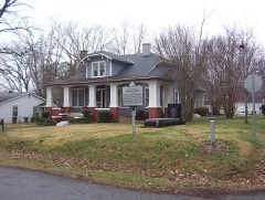 | W. E. Palmer House | building | 1978 | 78002604 |
| Ripley Fire Lookout Tower | structure | 2020 | 100004684 | |
| US Post Office | building | 1988 | 88001582 | |
| Wardlaw-Steele House | building | 1980 | 80003844 |
Every wildfire the federal occurrence database records inside this county: 284 of them, burning about 2,481 acres. 2 started naturally and 61 were recorded as arson. Each settlement page carries the fires within five miles of it.
| Reported cause | Fires |
|---|---|
| Debris and open burning | 172 |
| Arson/incendiarism | 61 |
| Missing data/not specified/undetermined | 20 |
| Equipment and vehicle use | 12 |
| Smoking | 6 |
| Railroad operations and maintenance | 5 |
| Natural | 2 |
| Misuse of fire by a minor | 2 |
| Recreation and ceremony | 2 |
| Other causes | 1 |
| Power generation/transmission/distribution | 1 |
The five largest, by the area the report gives. Four of them were set deliberately.
| Date | Cause | Size | Reported by | Name on the report |
|---|---|---|---|---|
| 23 October 2010 | Arson/incendiarism | 316 acres | Tennessee Division of Forestry | EDITH FIRE |
| 14 November 1999 | Arson/incendiarism | 139 acres | Tennessee Division of Forestry | not named |
| 19 December 1997 | Debris and open burning | 122 acres | Tennessee Division of Forestry | not named |
| 25 November 2005 | Debris and open burning | 89 acres | Tennessee Division of Forestry | not named |
| 14 October 2006 | Debris and open burning | 70 acres | Tennessee Division of Forestry | not named |
| 8 January 2006 | Arson/incendiarism | 55 acres | Tennessee Division of Forestry | not named |
| 18 November 1999 | Arson/incendiarism | 54 acres | Tennessee Division of Forestry | not named |
| 12 September 2005 | Debris and open burning | 53 acres | Tennessee Division of Forestry | not named |
Every settlement page carries the fires within five miles of it - see the settlement index below.
The NOAA Storm Events Database holds 235 reports for this county, causing 9 deaths, 29 injuries and about $8,830,550 in recorded property damage. Each settlement page carries the reports that name it.
| Kind of event | Reports |
|---|---|
| Thunderstorm Wind | 137 |
| Hail | 49 |
| Tornado | 27 |
| Flash Flood | 15 |
| Flood | 4 |
| Lightning | 2 |
| Heavy Rain | 1 |
The most serious of them, by death, then injury, then recorded damage. The accounts are quoted exactly as the forecast office filed them.
| When | Event | Place named | Harm | What the report says |
|---|---|---|---|---|
| February 1950 | Tornado (F2) | not stated | 9 killed, 1 hurt, $25,000 | no account filed |
| January 1999 | Tornado (F2) | Halls | 11 hurt, $2,000,000 | The tornado formed just west of Halls and travelled east. A mobile home park was damaged west of Halls with eight homes ripped apart. In Halls, several homes sustained damage to roofs, porches and siding. The tornado moved through the north end of the business district flattening two business with several other buildings including a church suffering major damage. As the tornado exited Halls, it damaged roofs, toppled trees and demolished a solitary mobile home. A total of 49 structures were damaged or destroyed. |
| September 1959 | Tornado (F3) | not stated | 7 hurt, $250,000 | no account filed |
| December 1971 | Tornado (F1) | not stated | 3 hurt, $250,000 | no account filed |
| May 1967 | Tornado (F2) | not stated | 2 hurt, $250,000 | no account filed |
| May 1984 | Thunderstorm Wind | not stated | 2 hurt | no account filed |
| December 1978 | Tornado (F1) | not stated | 1 hurt, $250,000 | no account filed |
| April 2003 | Thunderstorm Wind | Ripley | 1 hurt, $10,000 | Several trees were blown down. One of these trees fell on a truck injuring the driver. |
| May 1990 | Thunderstorm Wind | not stated | 1 hurt | no account filed |
| May 2010 | Flash Flood | Oak Grove | $3,000,000 | Very heavy rain up to 20 inches produced devastating flooding across Lauderdale County. Twenty homes sustained at least minor damage. Twenty mobile homes and few businesses sustained damage as well. Five roads sustained major damage and fifteen roads received minor damage. The flash flood event transitioned into a flood event by late in the afternoon as heavy rain allowed rivers to rapidly rise and overflow their banks. |
| May 2011 | Flood | Fulton | $750,000 | The Mississippi River rose to near record levels during the beginning to middle part of May. A few homes along the river were flooded and sustained damage. Several thousand acres of agriculture fields were flooded. Several roads were flooded and/or damaged. The river remained above flood stage through the end of the month. |
| May 2010 | Flood | Halls | $500,000 | Very heavy rains produced a flash flooding event in Lauderdale County. As much as 20 inches of rain fell across Lauderdale County. The flash flooding event transitioned to a flood event by late afternoon of May 1st. The South Fork Forked Deer River in Halls rose quickly above flood stage. Many homes and roads were affected by the high water. |
| January 2008 | Tornado (EF1) | Double Bridges | $250,000 | The tornado touched down along Highway 88 about 4 miles west-northwest of Halls. A mobile home was shifted from its foundation and destroyed. The tornado continued east-northeast and crossed Double Bridges Road where it caused significant roof damage to one home and destroyed an outbuilding of another home. The tornado continued across Mill Creek Road to Church Road where three homes were damaged. The roof was blown off of one home and completely destroyed the kitchen area. The other two homes suffered roof damage, fence damage and a collapsed garage. The tornado continues east-northeast and reached its maximum intensity as it moved across Highway 51 in the Poplar Grove Community. The damage was rated as a strong EF1 tornado with winds of 110 mph. There was significant structural damage to one home with the complete loss of the roof. The house was also shifted off its foundation. A machine shed was also destroyed. Many trees were snapped and uprooted along the entire path of the tornado. In addition, several power lines were knocked down. The tornado then moved into Dyer County. |
| April 2025 | Tornado (EF1) | Woodville | $150,000 | A tornado touched down near Concord Road, about five miles northeast of Ripley. Large tree limbs were downed and a small barn was damaged. The tornado began to track northeast along Concord Road downing and uprooting additional trees. A barn along the road lost a portion of its wooden roof. Uprooted trees and snapped tree trunks were noted as the tornado tracked toward Wilkes Road. On Wilkes Road, an outbuilding lost a portion of its metal roof panels. Tree damage continued along the path as it neared the southeast side of Gates. A home on Mitchell Road lost its siding and tree damage continued to W Wardlow Street. The tornado lifted shortly after. Peak winds were estimated at 100 mph. |
| May 2009 | Flash Flood | Halls | $100,000 | Heavy rain produced flash flooding in Halls. Areas that were flooded include Sumrow Street, New Street, Industrial Road, Airport Street, Pearl Street and Fenton Street. Several trucks in the public works lot were flooded. Several homes were also flooded. |
| August 2010 | Lightning | Curve | $75,000 | Lightning struck a house on Carmack Road, north of Ripley. A fire started as a result causing a complete loss of the home. |
| June 2009 | Flash Flood | Ripley | $50,000 | Heavy rain produced flash flooding around Ripley. Several businesses along Highway 51 were damaged as six to eight inches of water engulfed the inside of the buildings. |
| April 2008 | Flash Flood | Double Bridges | $50,000 | Heavy rain caused the ground beneath a house to fall into Mills Creek. The house was located on Double Bridges-Unionville Road. A large tree on the side of the hill was also uprooted. |
| June 2018 | Thunderstorm Wind | Ripley | $30,000 | Roof ripped off motel. |
| March 2021 | Tornado (EF1) | Keyes Pt | $25,000 | The tornado crossed the river from Mississippi County, AR into Lauderdale County, Tennessee. The tornado destroyed a barn along Crutcher Lake Road and continued to the northeast before dissipating. Peak winds were estimated at 95 mph in Lauderdale County. |
| October 2019 | Tornado (EF0) | Pleasant Hill | $25,000 | Tornado touched down in southern Lauderdale County and tracked northeast toward Ripley, lifting before reaching the town. Large tree limbs were broken and a few trees were uprooted. There was minor roof damage to one home. |
| November 2007 | Thunderstorm Wind | Halls | $25,000 | Straight line winds overturned an 18-wheeler on Highway 51 North near Halls. In addition, a roof was blown off a mobile home and damaged its support on Edith Nankipoo Road. Several trees were also knocked down in the area. |
| October 2007 | Thunderstorm Wind | Ripley | $25,000 | Several trees and power lines were blown down. Some of the trees fell on some houses. A few gas lines were busted as well. |
| June 2004 | Thunderstorm Wind | Gates | $25,000 | One home had half of its porch blown off and a kitchen window blown out. Several barns were damaged. Some trees and power lines were knocked down. |
| August 2003 | Thunderstorm Wind | Ripley | $25,000 | Some homes were damaged. Many trees and power lines were blown down. |
| April 1999 | Thunderstorm Wind | Ripley | $25,000 | A couple of homes were damaged. A few trees and power poles were blown down as well. |
| July 1998 | Lightning | Ripley | $25,000 | A building housing a pharmacy, hair salon and child abuse center was destroyed by a fire started by lightning. |
| February 1990 | Tornado (F1) | not stated | $25,000 | no account filed |
| November 1989 | Tornado (F1) | not stated | $25,000 | no account filed |
| April 1973 | Tornado (F1) | not stated | $25,000 | no account filed |
| March 1953 | Tornado (F1) | not stated | $25,000 | no account filed |
| April 2025 | Thunderstorm Wind | Gates | $20,000 | A home suffered significant damage from the rear flank downdraft of the Gates tornado. |
| March 2008 | Thunderstorm Wind | Edith | $20,000 | Straight line winds blew a tree onto a home near Edith. A convenience store on Highway 51 sustained damage to an awning from the winds as well. |
| July 1995 | Thunderstorm Wind | Asbury | $20,000 | A large oak tree was knocked down damaging a carport and demolishing a truck while falling. |
| March 2026 | Thunderstorm Wind | Ripley | $15,000 | Straight-line winds knocked down 5-10 power poles in Ripley. |
| April 2025 | Tornado (EF0) | Ft Pillow | $15,000 | A weak tornado formed near the Hatchie River in southern Lauderdale County. The tornado moved quickly to the northeast and produced mainly tree damage as it approached the Cherry community near Ft. Pillow. The tornado moved through the Cherry community, damaged a barn, and uprooted trees along Highway 371. In addition, the doors were blown out of a church across the street from the barn on Highway 371. The tornado tracked northeastward across a field to Pipkin Rd causing additional tree damage before dissipating in a wooded area north of Highway 87. This survey was aided by the presence of a Tornado Debris Signature and analysis of Sentinel-2 satellite data. Peak winds were estimated at 85 mph. |
| August 2023 | Thunderstorm Wind | Dry Hill | $15,000 | Several trees were knocked down across Ripley. Some fell on powerlines knocking them down as well. |
| May 2004 | Thunderstorm Wind | Countywide | $15,000 | Numerous trees and power lines were blown down across the county. |
| May 2003 | Thunderstorm Wind | Countywide | $15,000 | Numerous trees and power lines were knocked down across the county. |
| March 2026 | Thunderstorm Wind | Double Bridges | $10,000 | Trees were knocked down, and a roof was damaged. |
| April 2025 | Tornado (EF0) | Woodville | $10,000 | A brief, weak tornado formed near the intersection of Curve Woodville Road and Honey Lane, producing minor damage to a home. Sporadic tree damage was noted as the tornado moved quickly to the north-northeast, crossing Concord Road. This tornado crossed the path of a simultaneous tornado just west of Concord Road, lifting before reaching John White Road. This survey was aided by the presence of a Tornado Debris Signature and analysis of Sentinel-2 satellite data. Peak winds were estimated at 85 mph. |
| April 2025 | Tornado (EF1) | Opossum | $10,000 | A brief tornado formed near Williams Switch Road and Joe Barfield Road, causing minor tree damage. This tornado moved northeast toward the Asbury community, continuing sporadic tree damage before lifting north of Asbury Glimp Road. This survey was aided by the presence of a Tornado Debris Signature and analysis of Sentinel-2 satellite data. Peak winds were estimated at 90 mph. |
| April 2025 | Thunderstorm Wind | Gates | $10,000 | A small outbuilding sustained damage from the rear flank downdraft of the Gates tornado. |
| April 2025 | Thunderstorm Wind | Ft Pillow | $10,000 | Trees and a small outbuilding were damaged during a squall line. |
| February 2018 | Flood | Glimp | $10,000 | Heavy rain resulted in the flooding of Highway 371 and Highway 87. Around a half dozen secondary roads were also flooded. |
| March 2017 | Thunderstorm Wind | Halls | $10,000 | Carport lifted off ground and backyard playground equipment blown over. |
| June 2009 | Thunderstorm Wind | Halls | $10,000 | Straight line winds damaged a roof off of Highway 88 near Halls. In addition, utility poles and power lines were knocked down near Ripley. |
| May 2004 | Thunderstorm Wind | Henning | $10,000 | Some trees and power lines were blown down. |
| August 2002 | Thunderstorm Wind | Henning | $10,000 | Several trees and power lines were blown down. |
| August 2002 | Thunderstorm Wind | Halls | $10,000 | Several trees and power lines were knocked down. |
| July 2002 | Thunderstorm Wind | Halls | $10,000 | Several trees and power lines were knocked down. |
| April 2001 | Thunderstorm Wind | Halls | $10,000 | Some trees were blown down. |
| May 2001 | Thunderstorm Wind | Knob Creek | $10,000 | Several trees and power lines were knocked down. |
| May 2000 | Thunderstorm Wind | Countywide | $10,000 | Numerous trees were blown down across the county. |
| July 2000 | Thunderstorm Wind | Ashport | $10,000 | Several trees and power lines were knocked down. |
| February 1999 | Thunderstorm Wind | Ripley | $10,000 | A building had its gutters blown off. Several trees were knocked down. |
| May 2025 | Thunderstorm Wind | Ripley | $8,000 | Numerous down trees in Ripley. |
| April 2025 | Thunderstorm Wind | Gates | $8,000 | Trees trunks were snapped from the rear flank downdraft of the Gates tornado. |
| April 2025 | Thunderstorm Wind | Gates | $8,000 | Trees were uprooted from the rear flank downdraft of the Gates tornado. |
| April 2008 | Thunderstorm Wind | Oak Grove | $6,000 | Straight line winds blew trees down in and around Fort Pillow State Park. |
The Survey's mineral resources record lists 28 workings inside this county. 9 still produce and 19 are closed or unrecorded. Each settlement page carries the workings within five miles of it.
| Commodity | Workings |
|---|---|
| Sand and Gravel, Construction | 26 |
| Clay | 2 |
The least common of them first, because a county's hundredth gravel pit says nothing its first ten did not.
| Where | Site | Commodity | Status | Recorded |
|---|---|---|---|---|
| Dr.M.M. Lindsay Property Prospect | Clay | Prospect | ||
| Ripley Pit | Clay | Past Producer | ||
| #1 Williams Pit Scoggins Gravel Co. | Sand and Gravel, Construction | Producer | Unconsolidated Sediments | |
| #15 Smith Pit | Sand and Gravel, Construction | Producer | Unconsolidated Sediments | |
| #16 Craig Pit | Sand and Gravel, Construction | Producer | Unconsolidated Sediments | |
| #4 Voss Pit | Sand and Gravel, Construction | Producer | Unconsolidated Sediments | |
| Butler Pit | Sand and Gravel, Construction | Past Producer | Unconsolidated Sediments | |
| Butler Pit | Sand and Gravel, Construction | Past Producer | ||
| Crihfield Pit | Sand and Gravel, Construction | Producer | Unconsolidated Sediments | |
| Crihfield Pit | Sand and Gravel, Construction | Past Producer | ||
| Crihield Pit | Sand and Gravel, Construction | Past Producer | Sedimentary | |
| Mcwilliams Pit | Sand and Gravel, Construction | Producer | Unconsolidated Sediments | |
| Mcwilliams Pit | Sand and Gravel, Construction | Past Producer | Sedimentary | |
| Mcwilliams Pit | Sand and Gravel, Construction | Past Producer | ||
| Morris Pit | Sand and Gravel, Construction | Past Producer | Unconsolidated Sediments | |
| Morris Pit | Sand and Gravel, Construction | Past Producer | ||
| Number 1 Williams Pit | Sand and Gravel, Construction | Past Producer | Sedimentary | |
| Number 1 Williams Pit | Sand and Gravel, Construction | Past Producer | ||
| Number 15 Smith Pit | Sand and Gravel, Construction | Past Producer | Sedimentary | |
| Number 15 Smith Pit | Sand and Gravel, Construction | Past Producer | ||
| Number 16 Craig Pit | Sand and Gravel, Construction | Past Producer | Sedimentary | |
| Number 16 Craig Pit | Sand and Gravel, Construction | Past Producer | ||
| Number 4 Voss Pit | Sand and Gravel, Construction | Past Producer | Sedimentary | |
| Number 4 Voss Pit | Sand and Gravel, Construction | Past Producer | ||
| Robison Pit | Sand and Gravel, Construction | Producer | Unconsolidated Sediments | |
| Robison Pit | Sand and Gravel, Construction | Past Producer | Sedimentary | |
| Robison Pit | Sand and Gravel, Construction | Producer | ||
| Smith Pit | Sand and Gravel, Construction | Producer |
Named settlements recorded in the Geographic Names Information System, each with the topographic sheets covering it. Villages, hamlets and abandoned places alike. Each is shown with the nearest named watercourse or landform and the survey quadrangle it falls on.
District 5 · 38063 · Near Island Number Twentyseven · Rosa quadrangle
10 sheets, 1939 to 1986
District 5 · 38041 · By Chickasaw Bluff Number One · Nodena quadrangle
10 sheets, 1956 to 1986
District 5 · 38063 · Near Kate Aubrey Towhead · Osceola quadrangle
10 sheets, 1956 to 1986
District 1 · 38041 · On Campground Creek · Fort Pillow quadrangle
9 sheets, 1956 to 1986
The vanished settlements of Lauderdale County: the places named above that are no longer on the map.