 Block
From the record
8 National Register listings published here.
Sources: the National Register database, National Park Service
46 topographic sheets cover 56 settlements here, and 8 properties are on the National Register of Historic Places.
8 National Register listings published here.
Sources: the National Register database, National Park Service
Every property in this county listed on the National Register of Historic Places, with the year it was listed and the federal nomination document.
| Photograph | Property | Type | Listed | Reference |
|---|---|---|---|---|
 | Belview School | building | 2007 | 07000189 |
 | Cloyd Hotel | building | 1986 | 86002855 |
 | Counts Hotel | building | 1986 | 86002856 |
 | Donoho Hotel Historic District | district | 1986 | 86002857 |
 | Galen Elementary School | building | 1993 | 93000030 |
| Keystone School | building | 93000031 | ||
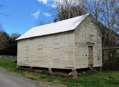 | Long Creek School | building | 1993 | 93000032 |
 | Red Boiling Springs Bank | building | 2013 | 13000747 |
Every wildfire the federal occurrence database records inside this county: 137 of them, burning about 914 acres. None started naturally and 62 were recorded as arson. Each settlement page carries the fires within five miles of it.
| Reported cause | Fires |
|---|---|
| Arson/incendiarism | 62 |
| Debris and open burning | 56 |
| Missing data/not specified/undetermined | 9 |
| Equipment and vehicle use | 5 |
| Smoking | 2 |
| Power generation/transmission/distribution | 1 |
| Recreation and ceremony | 1 |
| Misuse of fire by a minor | 1 |
The five largest, by the area the report gives. Five of them were set deliberately.
| Date | Cause | Size | Reported by | Name on the report |
|---|---|---|---|---|
| 7 March 2007 | Debris and open burning | 94 acres | Tennessee Division of Forestry | HICKS HOLLOW |
| 28 February 2001 | Debris and open burning | 60 acres | Tennessee Division of Forestry | not named |
| 13 April 1999 | Arson/incendiarism | 45 acres | Tennessee Division of Forestry | not named |
| 22 November 1998 | Arson/incendiarism | 40 acres | Tennessee Division of Forestry | not named |
| 31 December 1999 | Arson/incendiarism | 37 acres | Tennessee Division of Forestry | not named |
| 11 April 1997 | Debris and open burning | 35 acres | Tennessee Division of Forestry | not named |
| 31 March 1998 | Arson/incendiarism | 30 acres | Tennessee Division of Forestry | not named |
| 2 March 2006 | Arson/incendiarism | 29 acres | Tennessee Division of Forestry | not named |
Every settlement page carries the fires within five miles of it - see the settlement index below.
The NOAA Storm Events Database holds 242 reports for this county, causing 13 deaths, 44 injuries and about $24,666,560 in recorded property damage. Each settlement page carries the reports that name it.
| Kind of event | Reports |
|---|---|
| Thunderstorm Wind | 140 |
| Hail | 42 |
| Flash Flood | 35 |
| Tornado | 12 |
| Lightning | 7 |
| Flood | 4 |
| Heavy Rain | 2 |
The most serious of them, by death, then injury, then recorded damage. The accounts are quoted exactly as the forecast office filed them.
| When | Event | Place named | Harm | What the report says |
|---|---|---|---|---|
| February 2008 | Tornado (EF3) | Green Grove | 13 killed, 44 hurt, $14,100,000 | Thirteen people were killed, and 44 folks were injured. Most of the fatalities occurred in Williams, just northwest of Lafayette. Also, 170 homes were destroyed, and 9 homes had major damage. ||There was one indirect fatality, a male 48 years of age, due to carbon monoxide poisoning in his home from a generator on Feb. 6, 2008.||Pres. George W. Bush toured Macon County destruction on February 8th and promised relief to individuals. ||The logging industry in Macon County was hit hard. About a million dollars worth of trees were destroyed, which will take decades to replenish. It was estimated that the tornado outbreak did 10 million dollars worth of damage to trees in the state of Tennessee.||One large brick home worth about 350 thousand dollars was poorly built. The bricks rested on cinder blocks that were not cemented. This was noticed on a storm survey.||Schools were closed for over a week, and classes did not start again until Tuesday, February 19.||FEMA spent 4.1 million dollars for housing displaced residents in trailers. |
| August 2010 | Flood | Cross Rd | $5,000,000 | Heavy flooding of low lying areas across the county destroyed tobacco crops that were planted in these areas. Thirty roads across the county were reported to have at least moderate damage, mainly across the eastern portion of the county, with 24 of those roads being closed. Per the wet soil conditions, several trees also fell across county roadways. Emergency officials evacuated about 50 nursing home residents from a facility close to a rising creek. Name and exact location of the creek was unknown.||Newspapers also reported that the counties highway department stated that 96 roads were damaged in the flooding, with 22 of those suffering moderate to severe damage.||All of this damage was the result of 7, to as locally high as 10 inches in a few locations, of rainfall across the county. |
| July 2015 | Flash Flood | Cross Rd | $1,000,000 | Major flash flooding affected much of Macon County during the morning hours on July 3. Numerous roads throughout the county were impassable and closed due to high water, including Highway 10, Main Street, Galen Road, and Long Creek Road. Other roads were washed away and destroyed, such as Westfork Creek Road. Many homes, businesses and vehicles were also flooded, and 11 homes were destroyed by flooding in the western part of the county. 20 water rescues were also performed by emergency personnel, including two residents rescued from flooded homes in Lafayette. A CoCoRaHS observer 3.7 miles NNW of Lafayette measured 4.22 inches of rain over the 24 hour period ending at 9am on July 3. |
| March 2023 | Tornado (EF1) | Hillsdale | $500,000 | This narrative continues and concludes a tornado that began in far northern Trousdale County. Once this tornado tracked into Macon County near Rose Lane, property damage was found in the form of minor roofing and shingle damage along with a flipped propane tank as well as an outbuilding set on cinder blocks that was moved about 50 feet. The family that lives at the residence with the flipped propane tank had to temporarily evacuate due to a gas leak. The tornado strengthened as it approached Dixon Creek Road, and this is where the most significant damage was found with EF1 tornado damage and estimated peak winds of 95 mph. A residence here lost about 60 percent of their roof, six outbuildings on the property were completely destroyed, and multiple trees were uprooted. The tornado weakened after crossing Dixon Creek Road, causing minor roofing damage to barns and other outbuildings before it lifted at Sycamore Valley Road. Damages are estimated for Macon County. |
| May 2016 | Flash Flood | Cross Rd | $500,000 | Significant flash flooding affected much of western Macon County. Numerous roads were flooded and closed, including Green Grove Road, Williams Road, and several roads in Lafayette. Several homes were also reportedly flooded in these same areas. |
| April 1998 | Thunderstorm Wind | Willette | $500,000 | 30 to 50 homes in the Willette-Jennings Creek area had light to moderate damage from strong thunderstorm winds. 2 barns were completely destroyed, and the roof was taken off the Willette Head Start Center. Most of the damages to homes were from broken windows and vinyl siding. There was roof damage to some homes as well. |
| May 2010 | Flood | Cross Rd | $450,000 | Numerous homes, numerous businesses, numerous non comercial buildings, along with several county, state, and federal roads across the county received damage due to the flood. |
| June 2025 | Tornado (EF0) | Green Vly | $250,000 | An EF0 tornado touched down north of Lafayette near Sparrow Road and continued northeast along Oak Knob Road where a path of timber damage occurred. The tornado also caused damage to a few residences and carports. Damage was more sporadic to the northeast, but continued to Akersville Road before dissipating. Damages are a rough estimate. |
| March 1977 | Tornado (F2) | not stated | $250,000 | no account filed |
| January 2013 | Tornado (EF0) | Friendship | $175,000 | An EF0 tornado touched down in northeast Macon County about 7 miles northeast of Lafayette. The tornado touched down along Owens Road just north of Holland Road and continued northeast for 1.5 miles to just east of Jimtown Road and south of Heady Ridge Road. An older home received significant damage and a barn suffered considerable roof loss. A few hundred trees were snapped and uprooted along the path. |
| July 1996 | Lightning | Green Grove | $150,000 | no account filed |
| July 2016 | Thunderstorm Wind | Lafayette | $100,000 | Numerous trees and power lines were blown down all across Macon County with many falling on homes and outbuildings. One home was reportedly destroyed from the number of trees falling onto it. Some roads with trees down included Ellington Drive, Scottsville Road, Old Highway 52, and Sullivan Road. Nearly 5000 customers without power. |
| June 2009 | Lightning | Gap Of The Ridge | $100,000 | Lightning struck a multi-story well constructed brick home at 1106 Hightower Road. It caused an attic fire that lasted from 4 PM to 10 PM. Three fire fighters were transported to the hospital with smoke inhalation and chest pains. They were later released. |
| May 1995 | Tornado (F1) | Green Grove | $100,000 | A tornado touched down near the town of Green Grove. One barn was blown entirely on the roadway while another barn was blown down. Several homes were damaged. Eighty tombstones were destroyed. Numerous trees were knocked down. |
| May 2020 | Thunderstorm Wind | Lafayette | $85,430 | Numerous trees and power lines were blown down across Macon County. |
| January 2013 | Tornado (EF0) | Horsleys | $85,000 | An EF0 tornado began west of Clampit Hollow Road and moved northeast before lifting east of Marshall Lane. Dozens of trees were snapped, a couple older barns were destroyed, and an outbuilding was damaged along an approximate 1 mile path over far southwestern Macon County. |
| March 1997 | Flash Flood | Lafayette | $80,000 | Several bridges and roads were washed out. |
| June 2019 | Thunderstorm Wind | Green Vly | $75,000 | An unusually large and intense 8 mile long by 1.5 mile wide downburst moved to the southeast out of southern Kentucky across northern Macon County, generally from around the Kentucky border at Wix Hollow Road southeastward across Red Hill Road, Driver Hill Road, Oak Knob Road, Underwood Road, Akersville Road, Driver Road, Knight Road, Smith Hale Road, Highway 261, to Pumpkintown Road. Along this path, dozens of trees were snapped and uprooted, numerous barns were damaged or destroyed, a few homes were damaged by fallen trees, and several power poles and lines were blown down. |
| July 2010 | Thunderstorm Wind | Sunrise | $75,000 | On Highland Road,two tobacco barns were destroyed. |
| June 2009 | Thunderstorm Wind | Red Boiling Spgs | $50,000 | Widespread wind damage was reported across northeast portions of the county. What type of actual wind damage was unkown. This included several downed large trees in the Galen Road at Coleytown Road Intersection and in the Frog Pond Community. Large trees were also blown down in Red Boiling Springs, one on McClure Street and two on High Street. In addition, the roof was reported to have collapsed on the Old Holland Fruit Stand Store Building on Red Boiling Springs Road. |
| June 2009 | Thunderstorm Wind | Lafayette Arpt | $50,000 | A strong outflow wind associated with a thunderstorm mangled the stands at the Macon County Fairgrounds, causing considerable damage. |
| January 2008 | Thunderstorm Wind | Red Boiling Spgs | $50,000 | Two trees fell on a mobile home owned by Ms. Dorothy Whitley on North Springs Rd. The home was completely destroyed. |
| January 1999 | Thunderstorm Wind | Southwest Portion | $50,000 | 2 barns, several outbuildings and a house trailer were blown over. Numerous trees were blown down. |
| July 1997 | Thunderstorm Wind | Lafayette Arpt | $40,000 | Strong thunderstorm winds flipped over an airplane at the airport. The airplane was a 1946 Ercoupe. Damage also occurred to the wing of a Cessna 172. 3 large hangar doors were damaged and were broken off their tracks. Near the airport, a tree fell on top of a house. |
| May 2004 | Thunderstorm Wind | Underwood | $30,000 | Law enforcement reported several homes were damaged. Trees and power lines were down. The storm blew a tree over a van. There was minor roof damage to the home. Also, a propane tank was blown off its foundation. |
| June 2019 | Tornado (EF1) | Green Vly | $25,000 | A short but intense EF-1 tornado touched down in far northern Macon County near Green Valley Road and moved eastward across Oak Knob Road and along Underwood Road before lifting. Hundreds of trees were snapped and uprooted along the path, a few homes were damaged by falling trees, and several barns and outbuildings were damaged. The tornado damage was surrounded by a massive 8 mile long by 1.5 mile wide downburst which also caused scattered severe damage over a much wider area. |
| July 2016 | Flash Flood | Rocky Mound | $25,000 | Significant flash flooding affected southwestern Macon County, including areas around Lafayette and Siloam, with several roads flooded or damaged by flood waters. Roads that were flooded and closed included Highway 141, Epperson Springs Road, Brattontown Circle, Phillips Hollow Road, Leaths Branch Road, Hicks Hollow Road, and Green Grove Road. |
| July 2016 | Flash Flood | Cross Rd | $25,000 | Flash flooding affected western portions of Macon County. TEMA reported 2 roads were washed out by flooding with several other roads flooded and closed. No injuries or fatalities were reported. |
| May 2011 | Thunderstorm Wind | Lafayette | $25,000 | Several trees were reported downed county wide. |
| May 2010 | Lightning | Lafayette | $25,000 | Structure fire resulted from a lightning strike near the 600 Block of West End Ave. Extent of damage was unkown. |
| May 2010 | Flash Flood | Beech Bottom | $25,000 | State Highway 10 partially blocked by high water south of Lafayette. |
| February 2009 | Thunderstorm Wind | Lafayette | $25,000 | Trees were blown down county wide. |
| May 2009 | Thunderstorm Wind | Maple Grove | $25,000 | Several trees were reported blown down across the county. |
| July 2006 | Lightning | Red Boiling Spgs | $25,000 | Lightning struck a tree, then the bolt of lightning killed 18 heifers and one bull gathered underneath the tree. Mr. Tony Ferguson, owner of Lazy Brook Farm on Bethany Road, in Red Boiling Springs, estimated the loss at $20,000 to $25,000. |
| July 2012 | Thunderstorm Wind | Gap Of The Ridge | $20,000 | Several trees were downed across the county. |
| August 2008 | Thunderstorm Wind | Russell Hill | $20,000 | Trees were down on a car and outbuilding in the Russell Hill area. |
| June 2007 | Thunderstorm Wind | Red Boiling Spgs | $20,000 | Wind damage to ambulance station. The winds tore off part of the roof and collapsed the parking bay onto the ambulance inside the bay. Trees and signs in the are were blown down. Reed Bray Lumber and Metal suffered damage to their building...namely some walls were blown down. The Macon Bank and Trust billboard was toppled by the strong winds in Red Boiling Springs. |
| April 2010 | Tornado (EF0) | Eulia | $16,000 | A tornado with max winds of 85 mph touched down at the intersection|of state highway 52 and rocky mound road. Damaged continued to the|north northeast for an approximately length of 1.5 miles and a|maximum width of 50 yards. Multiple shallow rooted trees were uprooted|with one small barn destroyed. |
| April 2025 | Thunderstorm Wind | Red Boiling Spgs | $15,000 | Severe thunderstorm winds peeled the roof off of a tin shed in Red Boiling Springs. Damages are a rough estimate. |
| May 2024 | Thunderstorm Wind | Red Boiling Spgs | $15,000 | Downed trees were reported near Red Boiling Springs. Damages are a rough estimate. |
| May 2024 | Thunderstorm Wind | Lafayette | $15,000 | A Facebook user reported several downed trees due to severe thunderstorm winds in Lafayette around Ellington Drive at Meador Drive. Damages are a rough estimate. |
| June 2023 | Thunderstorm Wind | Red Boiling Spgs | $15,000 | Severe thunderstorm winds downed a tree onto a house near Lafayette Road and East Main Street in Red Boiling Springs. The emergency manager also reported many power outages across Macon County. No injuries were reported, and damages are a rough estimate. |
| January 2020 | Thunderstorm Wind | Maple Grove | $15,000 | At least 15 trees were blown down on Fox Run Lane. |
| May 2018 | Flash Flood | Cross Rd | $15,000 | Widespread flash flooding was reported across western and central Macon County with several homes flooded and numerous roads impassable due to high water. Westfork Creek Road was washed out. Two swift water rescues were conducted by emergency personnel. |
| June 2011 | Thunderstorm Wind | Haysville | $15,000 | Trees were blown down at the Scottsville Road and Shiloh Road intersection. Numerous trees were also blown down across other portions of western Macon County. |
| May 2011 | Thunderstorm Wind | Eulia | $15,000 | Sheriffs office reported several trees were downed across western portions of the county. |
| August 2010 | Thunderstorm Wind | Green Vly | $15,000 | Sheriffs office reported trees down on Shiloh Lane and also at the intersection of Green Valley Road and Sparrow Road. |
| September 2025 | Thunderstorm Wind | Lafayette | $10,000 | Severe thunderstorm winds peeled the tin roof of a barn up. Exact location in Lafayette was unknown. Damages are a rough estimate. |
| September 2025 | Thunderstorm Wind | Drapers Xrds | $10,000 | Severe thunderstorm winds downed a tree onto a mobile home along Taurus Farm Road. Five people inside the mobile home were trapped, but injuries were not reported. Damages are a rough estimate. |
| September 2024 | Thunderstorm Wind | Lafayette | $10,000 | Severe thunderstorm winds downed trees in the Lafayette area. Damages are a rough estimate. |
| May 2024 | Thunderstorm Wind | New Harmony | $10,000 | Severe thunderstorm winds downed several trees along New Harmony Road near Lafayette. Damages are a rough estimate. |
| May 2024 | Thunderstorm Wind | Days Xrds | $10,000 | Severe thunderstorm winds downed several trees along Highway 52 near Lafayette. Damages are a rough estimate. |
| May 2024 | Thunderstorm Wind | Greenwood | $10,000 | Severe thunderstorm winds downed trees south of Highway 52 near Red Boiling Springs. Damages are a rough estimate. |
| July 2022 | Thunderstorm Wind | Lafayette | $10,000 | Widespread tree damaged occurred across Macon County. |
| May 2021 | Tornado (EF0) | Brattontown | $10,000 | This small, weak tornado touched down on Brattowntown Circle on the west side of Lafayette and moved southeast, knocking down several trees and power lines, and partially blowing the roof off a convienence store on Highway 52. Lafayette EMS personnel captured the tornado on video as it passed south of their station located at Hartsville Road and Highway 52. The tornado is estimated to have lifted near Hunt Lane. |
| December 2019 | Flash Flood | Lafayette | $10,000 | Multiple cars were pulled out of floods waters on roads across the county. |
| May 2018 | Thunderstorm Wind | Lafayette | $10,000 | Numerous trees and power lines were blown down across western and central Macon County. |
| March 2017 | Thunderstorm Wind | Lafayette | $10,000 | A NWS storm survey found a 3.2 mile long by 300 yard wide swath of wind damage struck areas from the north side of Lafayette eastward to around 3 miles east-northeast of Lafayette. A metal awning was blown down at the DT McCalls building on Scottsville Road at Vinson Road in northern Lafayette. Large tree limbs were blown down on Ellington Drive and on Akersville Road. Farther to the east, a tree was uprooted on Chaffin Road and an outbuilding had roof damage on Chaffin Road at Huntsman Lane. A small amount of siding was peeled off a home on Coleytown Road at Galen Road, and some large branches were blown down nearby. Winds were estimated up to 60 mph. |
| February 2014 | Thunderstorm Wind | Lafayette | $10,000 | Trees were reportedly blown down all across Macon County, including several in Lafayette. |
| January 2013 | Thunderstorm Wind | Lafayette | $10,000 | Numerous trees were blown down all across Macon County. |
The Survey's mineral resources record lists 16 workings inside this county. 2 still produce and 14 are closed or unrecorded. Each settlement page carries the workings within five miles of it.
| Commodity | Workings |
|---|---|
| Uranium | 7 |
| Oil Shale | 7 |
| Uranium, Oil Shale | 6 |
| Oil Shale, Uranium | 1 |
| Stone, Crushed/Broken, Limestone, General | 1 |
| Stone, Crushed/Broken | 1 |
The least common of them first, because a county's hundredth gravel pit says nothing its first ten did not.
| Where | Site | Commodity | Status | Recorded |
|---|---|---|---|---|
| Hillsdale Quarry | Stone, Crushed/Broken, Limestone, General | Producer | Limestone | |
| Hillsdale Quarry | Stone, Crushed/Broken | Producer | ||
| Outcrop Sample For Uranium | Oil Shale, Uranium | Occurrence | ||
| Outcrop Sample For Uranium | Uranium, Oil Shale | Occurrence | ||
| Outcrop Sample For Uranium | Uranium, Oil Shale | Occurrence | ||
| Outcrop Sample For Uranium | Uranium, Oil Shale | Occurrence | ||
| Outcrop Sample For Uranium | Uranium, Oil Shale | Occurrence | ||
| Outcrop Sample For Uranium | Uranium, Oil Shale | Occurrence | ||
| Outcrop Sample For Uranium | Uranium, Oil Shale | Occurrence | ||
| Outcrop Sample For Uranium | Uranium, Oil Shale | Occurrence | ||
| Outcrop Sample For Uranium | Uranium, Oil Shale | Occurrence | ||
| Outcrop Sample For Uranium | Uranium, Oil Shale | Occurrence | ||
| Outcrop Sample For Uranium | Uranium, Oil Shale | Occurrence | ||
| Outcrop Sample For Uranium | Uranium, Oil Shale | Occurrence | ||
| Outcrop Sample For Uranium | Uranium, Oil Shale | Occurrence | ||
| Outcrop Sample For Uranium | Uranium, Oil Shale | Occurrence |
Named settlements recorded in the Geographic Names Information System, each with the topographic sheets covering it. Villages, hamlets and abandoned places alike. Each is shown with the nearest named watercourse or landform and the survey quadrangle it falls on.
District 4 · 37083 · On Dark Shrum Branch · Hillsdale quadrangle
7 sheets, 1956 to 1994
District 2 · 37083 · Near McDonnell Hollow · Pleasant Shade quadrangle
10 sheets, 1932 to 1982
District 5 · 37083 · Near Wiseman Hollow · Lafayette quadrangle
11 sheets, 1931 to 1985
District 2 · 37150 · Near Goad Ridge · Pleasant Shade quadrangle
10 sheets, 1932 to 1982
District 1 · 37150 · Near Cotton Hollow · Red Boiling Springs quadrangle
10 sheets, 1931 to 1985
District 2 · 37083 · Near Dug Hollow · Pleasant Shade quadrangle
10 sheets, 1932 to 1982
District 10 · 37083 · Near Sulphur Spring Hollow · Lafayette quadrangle
11 sheets, 1931 to 1985
District 7 · 37083 · Near Meetinghouse Hollow · Lafayette quadrangle
11 sheets, 1931 to 1985
District 6 · 37186 · Near Saltpeter Cave Hollow · Lafayette quadrangle
11 sheets, 1931 to 1985
District 8 · 37083 · Near Fishburn Hollow · Lafayette quadrangle
11 sheets, 1931 to 1985
District 1 · 37150 · Near McClure Hollow · Red Boiling Springs quadrangle
10 sheets, 1931 to 1985
District 6 · 37186 · Near Sugar Camp Hollow · Westmoreland quadrangle
10 sheets, 1931 to 1985
District 2 · 37145 · Near Hesson Ridge · Pleasant Shade quadrangle
10 sheets, 1932 to 1982
District 1 · 37150 · Near Whitley Hollow · Red Boiling Springs quadrangle
10 sheets, 1931 to 1985