 Block
From the record
7 National Register listings published here.
Sources: the National Register database, National Park Service
33 topographic sheets cover 15 settlements here, and 7 properties are on the National Register of Historic Places.
7 National Register listings published here.
Sources: the National Register database, National Park Service
Every property in this county listed on the National Register of Historic Places, with the year it was listed and the federal nomination document.
| Photograph | Property | Type | Listed | Reference |
|---|---|---|---|---|
 | Bobo Hotel | building | 1994 | 94000283 |
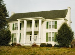 | Green-Evans House | building | 1992 | 92001713 |
| Hurdlow School | building | 2025 | 100011548 | |
 | Jack Daniel Distillery | building | 1972 | 72001248 |
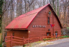 | Ledfords Mill | building | 1985 | 85000077 |
 | Lynchburg Historic District | district | 1996 | 96000771 |
 | Moore County Courthouse and Jail | building | 1979 | 79002452 |
Every wildfire the federal occurrence database records inside this county: 75 of them, burning about 531 acres. 1 started naturally and 5 were recorded as arson. Each settlement page carries the fires within five miles of it.
| Reported cause | Fires |
|---|---|
| Debris and open burning | 57 |
| Equipment and vehicle use | 5 |
| Arson/incendiarism | 5 |
| Missing data/not specified/undetermined | 3 |
| Misuse of fire by a minor | 2 |
| Power generation/transmission/distribution | 1 |
| Other causes | 1 |
| Natural | 1 |
The five largest, by the area the report gives. One of them was set deliberately.
| Date | Cause | Size | Reported by | Name on the report |
|---|---|---|---|---|
| 9 December 2020 | Debris and open burning | 111 acres | Tennessee Division of Forestry | MOORE COUNTY CUMBERLAND SPRINGS ROAD 3277 |
| 29 November 1999 | Debris and open burning | 65 acres | Tennessee Division of Forestry | not named |
| 13 November 1999 | Debris and open burning | 50 acres | Tennessee Division of Forestry | not named |
| 30 November 1999 | Debris and open burning | 30 acres | Tennessee Division of Forestry | not named |
| 12 March 2007 | Debris and open burning | 20 acres | Tennessee Division of Forestry | SYLER |
| 14 November 1999 | Debris and open burning | 20 acres | Tennessee Division of Forestry | not named |
| 31 January 2014 | Debris and open burning | 16 acres | Tennessee Division of Forestry | HENNESSEE |
| 19 August 1999 | Arson/incendiarism | 15 acres | Tennessee Division of Forestry | not named |
Every settlement page carries the fires within five miles of it - see the settlement index below.
The NOAA Storm Events Database holds 289 reports for this county, causing no deaths, 13 injuries and about $718,200 in recorded property damage. Each settlement page carries the reports that name it.
| Kind of event | Reports |
|---|---|
| Thunderstorm Wind | 216 |
| Flash Flood | 29 |
| Hail | 25 |
| Tornado | 13 |
| Lightning | 3 |
| Heavy Rain | 2 |
| Flood | 1 |
The most serious of them, by death, then injury, then recorded damage. The accounts are quoted exactly as the forecast office filed them.
| When | Event | Place named | Harm | What the report says |
|---|---|---|---|---|
| February 1952 | Tornado (F4) | not stated | 9 hurt, $250,000 | no account filed |
| February 2011 | Tornado (EF2) | Cumberland Spgs | 4 hurt | An EF-2 tornado with peak winds of 600 yards initially touched down southeast of downtown Lynchburg. The most significant damage occurred from eastern Moore county. In these locations mobile homes were destroyed, multiple power poles and trees were snapped, and homes sustained significant roof damage. |
| October 2010 | Tornado (EF1) | Pleasant Hill | $100,000 | An EF-1 tornado with peak winds up to 95 mph began near the intersection of Griffin and Harry Hill roads, continued through the Pleasant Hill Community, then lifted near Markay Lane. The most significant damage was to residential homes, with two homes losing covered porches. In addition, one hay barn was destroyed. Other damage was limited to snapped and uprooted trees that fell on residential structures and roof damage. |
| July 1997 | Thunderstorm Wind | Lynchburg | $50,000 | Local law enforcement reported several trees were blown down from 5 miles northeast of Lynchburg to 5 miles east of Lynchburg. Trees fell on several homes and on 2 cars. |
| April 1997 | Lightning | Lynchburg | $50,000 | Lightning struck a 130-year-old red oak tree. Chunks of wood weighing as much as 175 pounds flew about 50 yards. One large piece of wood was embedded in a tail light of a car. The lightning followed the trees roots digging a trench almost 3 feet deep into and under the house. Flying wood damaged the house and a total of 3 cars. |
| June 2011 | Thunderstorm Wind | Chestnut Ridge | $45,000 | Numerous trees were reported down across the county. One tree fell on and damaged a car. Some locations impacted included: Buckeye road, Pleasant Hill road, Highway 50, Tanyard Hill road, Bull Run road, Coffee Creek, Lost Creek County Line road, Bakertown road, and Damron road. |
| July 2013 | Thunderstorm Wind | Chestnut Ridge | $25,000 | Multiple trees were downed by thunderstorm winds along Mount Herman road and Highway 231. Several powerlines were also downed along Warren Hollow road. |
| December 2013 | Thunderstorm Wind | Lynchburg | $20,000 | A few trees were downed by thunderstorm winds on Cumberland Springs Road, onto Five Points Road and onto Highway 130 near Motlow Community College. A few powerlines were also downed by the thunderstorm winds. |
| June 2023 | Thunderstorm Wind | Lynchburg | $10,000 | A report was received of 6 to 8 trees with diameters of 18 to 24 inches were knocked down in Lynchburg. Time estimated by radar. |
| June 2014 | Thunderstorm Wind | Cumberland Spgs | $10,000 | Thunderstorm winds resulted in two heavily damaged outbuildings, along with knocking down power lines, a power pole and several trees. |
| August 1999 | Thunderstorm Wind | Lynchburg | $10,000 | Newspaper article account of a home losing part of its roof in strong thunderstorm winds. The home was located at Tims Ford Lake in Lost Creek Heights. |
| July 1997 | Thunderstorm Wind | Lynchburg | $10,000 | Local law enforcement reported 3 trees were blown down. One of those trees fell on top of the "Off The Beaten Path" building in downtown Lewisburg. |
| April 2009 | Thunderstorm Wind | Hurdlow | $9,000 | Multiple trees were reported blown down. Time was estimated from radar. |
| June 2010 | Thunderstorm Wind | Cumberland Spgs | $8,000 | Trees were blown down on Highway 55 in the Motlow College area. |
| June 2023 | Thunderstorm Wind | County Line | $5,000 | A gust front from decaying severe thunderstorms produced widespread strong to severe level thunderstorm winds across the entire county from north-northwest to south-southeast. There were a few reports of trees being knocked down due to the 50 to 60 mph wind gusts associated with this gust front. |
| March 2012 | Thunderstorm Wind | Chestnut Ridge | $5,000 | Trees and power lines were knocked down on Highway 129 near the Bedford County line. Time estimated by radar. |
| May 2010 | Thunderstorm Wind | Pleasant Hill | $5,000 | A tree was blown down onto Harry Hill road. |
| January 2005 | Thunderstorm Wind | Lynchburg | $5,000 | A roof of a building was heavily damaged due to thunderstorm winds. |
| August 2022 | Thunderstorm Wind | Marble Hill | $3,000 | Two trees were knocked down on Wet Prog road. A tree was also hanging over the road. Time was estimated by radar. |
| December 2013 | Thunderstorm Wind | Lynchburg | $3,000 | A few trees were downed by thunderstorm winds along Highway 231 at Chestnut Ridge. |
| July 2009 | Lightning | Cumberland Spgs | $3,000 | A tree was down and on fire on Highway 41A near the Bedford, Coffee, and Moore county line. |
| February 2025 | Thunderstorm Wind | Raysville | $2,000 | Trees were knocked down on Lynchburg Highway between Lynchburg and Tullahoma. |
| May 2025 | Thunderstorm Wind | County Line | $2,000 | A tree was knocked down. Time estimated by radar. |
| May 2025 | Thunderstorm Wind | Bakertown | $2,000 | A tree was knocked down. Time estimated by radar. |
| May 2025 | Thunderstorm Wind | Lois | $2,000 | A tree was knocked down. Time estimated by radar. |
| May 2025 | Thunderstorm Wind | County Line | $2,000 | A tree was knocked down. Time estimated by radar. |
| May 2025 | Thunderstorm Wind | Lynchburg | $2,000 | A tree was knocked down. Time estimated by radar. |
| May 2025 | Thunderstorm Wind | Lynchburg | $2,000 | A tree was uprooted along Main Street in Lynchburg. |
| May 2025 | Thunderstorm Wind | Raysville | $2,000 | A tree was knocked down. Time estimated by radar. |
| May 2025 | Thunderstorm Wind | Cumberland Spgs | $2,000 | A tree was knocked down. Time estimated by radar. |
| December 2025 | Thunderstorm Wind | Bakertown | $2,000 | Trees were reported down at the intersection of Damron road and Tanyard Hill Road. |
| December 2025 | Thunderstorm Wind | Cumberland Spgs | $2,000 | Trees were reported down on N Cumberland Springs road. |
| December 2025 | Thunderstorm Wind | County Line | $2,000 | Trees were reported down near the intersection of Cobb Hollow road and Price Hollow road. |
| December 2025 | Thunderstorm Wind | County Line | $2,000 | Trees were reported down near the intersection of County Line road and highway 82. |
| December 2025 | Thunderstorm Wind | Ridgeville | $2,000 | Trees were reported down on Lost Creek road. |
| December 2025 | Thunderstorm Wind | Marble Hill | $2,000 | Trees were reported down on Marble Hill road near a campsite. |
| December 2025 | Thunderstorm Wind | Bakertown | $2,000 | Trees were reported down on Andy Anderson road. |
| December 2025 | Thunderstorm Wind | Ridgeville | $2,000 | Trees were reported down near the intersection of Hurricane Creek road and Shelton road. |
| March 2022 | Thunderstorm Wind | Lynchburg | $2,000 | Powerlines were reported down on Buckeye Loop Road. |
| June 2022 | Thunderstorm Wind | Lynchburg | $2,000 | Multiple trees were knocked down along Highway 50 east of Lynchburg. Time estimated by radar. |
| May 2009 | Thunderstorm Wind | Lois | $2,000 | A tree was blown down on Wabash Road. |
| May 2008 | Thunderstorm Wind | Marble Hill | $2,000 | Severe thunderstorm winds knocked down trees in the Marble Hill and Pleasant Hill communities. Power outages were also reported in the Charity community. |
| June 1995 | Thunderstorm Wind | Cumberland Springs | $2,000 | One tree was blown down on top of a power line. |
| May 2025 | Thunderstorm Wind | Cumberland Spgs | $1,000 | A tree was reported down at Cobb Hollow road and Hurricane Creek road. |
| May 2025 | Thunderstorm Wind | Pleasant Hill | $1,000 | A tree was knocked down on Hurricane Creek road. Time was estimated from radar data. |
| May 2025 | Thunderstorm Wind | Pleasant Hill | $1,000 | A tree was knocked down on Harry Hill Road. Time estimated by radar. |
| May 2024 | Thunderstorm Wind | Chestnut Ridge | $1,000 | A power line was knocked down at the intersection of Shelbyville Highway and Charity Road. |
| June 2024 | Thunderstorm Wind | Hurdlow | $1,000 | A tree was knocked down across the road. |
| June 2024 | Thunderstorm Wind | Lois | $1,000 | A tree was knocked down across the road. |
| June 2024 | Thunderstorm Wind | Ridgeville | $1,000 | A tree was knocked down across the road. |
| June 2024 | Thunderstorm Wind | Bakertown | $1,000 | A tree was knocked down across the road. |
| June 2024 | Thunderstorm Wind | County Line | $1,000 | A tree was knocked down across the road. |
| June 2024 | Thunderstorm Wind | Bakertown | $1,000 | A tree was knocked down across the road. |
| August 2024 | Thunderstorm Wind | Pleasant Hill | $1,000 | A tree was reported down at 216 Ashley road. Time was estimated from radar. |
| July 2024 | Thunderstorm Wind | Cumberland Spgs | $1,000 | A tree was reported down across the road at this location on Old Shelbyville Highway. |
| August 2023 | Thunderstorm Wind | Cumberland Spgs | $1,000 | Trees were knocked down near Tullahoma. Time estimated by radar. |
| December 2023 | Thunderstorm Wind | Raysville | $1,000 | Power lines were knocked down into the road at 110 Five Points Road. Time estimated by radar. |
| March 2022 | Thunderstorm Wind | Lois | $1,000 | A tree was reported down on Louse Creek Road. |
| March 2022 | Thunderstorm Wind | Bakertown | $1,000 | A tree was reported down on Grammar Hill Road. |
| March 2022 | Thunderstorm Wind | Raysville | $1,000 | One tree was reported down on Woosley Road. |
The Survey's mineral resources record lists 11 workings inside this county. 3 still produce and 8 are closed or unrecorded. Each settlement page carries the workings within five miles of it.
| Commodity | Workings |
|---|---|
| Stone, Crushed/Broken | 4 |
| Uranium, Oil Shale | 3 |
| Uranium | 3 |
| Oil Shale | 3 |
| Stone, Crushed/Broken, Limestone, General | 1 |
The least common of them first, because a county's hundredth gravel pit says nothing its first ten did not.
| Where | Site | Commodity | Status | Recorded |
|---|---|---|---|---|
| Moore County Highway Department Quarry | Stone, Crushed/Broken, Limestone, General | Producer | Limestone | |
| Outcrop Sample For Uranium | Uranium, Oil Shale | Occurrence | ||
| Outcrop Sample For Uranium | Uranium, Oil Shale | Occurrence | ||
| Outcrop Sample For Uranium | Uranium, Oil Shale | Occurrence | ||
| Outcrop Sample For Uranium | Uranium, Oil Shale | Occurrence | ||
| Outcrop Sample For Uranium | Uranium, Oil Shale | Occurrence | ||
| Outcrop Sample For Uranium | Uranium, Oil Shale | Occurrence | ||
| Lynchburg Quarry | Stone, Crushed/Broken | Past Producer | Limestone | |
| Lynchburg Quarry | Stone, Crushed/Broken | Producer | ||
| Moore County Highway Department | Stone, Crushed/Broken | Past Producer | ||
| Moore County Quarry Price Branch | Stone, Crushed/Broken | Producer |
Named settlements recorded in the Geographic Names Information System, each with the topographic sheets covering it. Villages, hamlets and abandoned places alike. Each is shown with the nearest named watercourse or landform and the survey quadrangle it falls on.
District 1 · 37352 · Near Possumtrot Ridge · Lynchburg East quadrangle
15 sheets, 1936 to 1981
District 4 · 37352 · On Dogtail Creek · Lynchburg East quadrangle
15 sheets, 1936 to 1981
District 1 · 37352 · Near Fox Hollow · Lynchburg East quadrangle
15 sheets, 1936 to 1981
District 3 · 37306 · On West Fork Robinson Creek · Lois quadrangle
12 sheets, 1936 to 1981
District 1 · 37352 · Near Stillhouse Hollow · Lynchburg East quadrangle
15 sheets, 1936 to 1981
District 2 · 37352 · Near Chestnut Ridge · Lynchburg East quadrangle
15 sheets, 1936 to 1981
District 4 · 37352 · Near Brandon Hollow · Lynchburg East quadrangle
15 sheets, 1936 to 1981
District 2 · 37352 · Near Sanders Hollow · Lynchburg East quadrangle
15 sheets, 1936 to 1981
District 2 · 37388 · Near Sam Burt Hill · Lynchburg East quadrangle
15 sheets, 1936 to 1981