 Block
From the record
5 National Register listings published here.
Sources: the National Register database, National Park Service
53 topographic sheets cover 19 settlements here, and 5 properties are on the National Register of Historic Places.
5 National Register listings published here.
Sources: the National Register database, National Park Service
Every property in this county listed on the National Register of Historic Places, with the year it was listed and the federal nomination document.
| Photograph | Property | Type | Listed | Reference |
|---|---|---|---|---|
| Dr. Richard Calvin Bromley House | building | 1995 | 95001373 | |
| Craig Family Farm | district | 2006 | 05001219 | |
| James Dickson House | building | 1985 | 85000668 | |
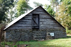 | Hufstedler Gravehouse | structure | 1987 | 87001038 |
 | Perry County Courthouse | building | 1995 | 95000339 |
Every wildfire the federal occurrence database records inside this county: 248 of them, burning about 3,687 acres. 6 started naturally and 82 were recorded as arson. Each settlement page carries the fires within five miles of it.
| Reported cause | Fires |
|---|---|
| Debris and open burning | 85 |
| Arson/incendiarism | 82 |
| Missing data/not specified/undetermined | 40 |
| Equipment and vehicle use | 12 |
| Recreation and ceremony | 8 |
| Other causes | 7 |
| Natural | 6 |
| Misuse of fire by a minor | 2 |
| Power generation/transmission/distribution | 2 |
| Fireworks | 2 |
| Smoking | 2 |
The five largest, by the area the report gives. Three of them were set deliberately.
| Date | Cause | Size | Reported by | Name on the report |
|---|---|---|---|---|
| 11 May 2007 | Natural | 585 acres | Tennessee Division of Forestry | ROCKHOUSE ROAD |
| 14 March 2005 | Arson/incendiarism | 264 acres | Tennessee Division of Forestry | HINSON ROAD |
| 13 November 2011 | Recreation and ceremony | 241 acres | Tennessee Division of Forestry | BUCK FORK |
| 11 August 2007 | Arson/incendiarism | 205 acres | Tennessee Division of Forestry | SLINK SHOALS |
| 22 February 2007 | Missing data/not specified/undetermined | 173 acres | Tennessee Division of Forestry | GOTAWAY FIRE |
| 20 March 2007 | Debris and open burning | 146 acres | Tennessee Division of Forestry | CCC RIDGE 2 |
| 20 March 2007 | Debris and open burning | 125 acres | Tennessee Division of Forestry | CCC RIDGE 1 |
| 1 November 2016 | Arson/incendiarism | 94 acres | Tennessee Division of Forestry | LICK CREEK RD FIRE |
Every settlement page carries the fires within five miles of it - see the settlement index below.
The NOAA Storm Events Database holds 222 reports for this county, causing 7 deaths, no injuries and about $6,812,800 in recorded property damage. Each settlement page carries the reports that name it.
| Kind of event | Reports |
|---|---|
| Thunderstorm Wind | 132 |
| Hail | 38 |
| Flash Flood | 29 |
| Tornado | 12 |
| Flood | 8 |
| Heavy Rain | 3 |
The most serious of them, by death, then injury, then recorded damage. The accounts are quoted exactly as the forecast office filed them.
| When | Event | Place named | Harm | What the report says |
|---|---|---|---|---|
| May 1999 | Tornado (F4) | Linden | 3 killed, $295,000 | An F4 tornado struck the town of Linden, located about 70 miles southwest of Nashville. The tornado damaged many homes, schools and businesses and churches. There were 3 fatalities. A 14 year old girl was sucked out of her home by the tornado as she, her father, and her mother were headed to the basement. Her dad was also sucked out of the home, but was found unharmed in the yard. The 14 year old girl was found 5 hours later in the rumble of their home. Hollis Hinson, 47 year old male and Perry County Trustee, was killed in his home. His girlfriend, 47 year old school teacher Patti Haston, was also killed in Mr. Hinson's house. The home was lifted off the foundation and flung into the woods and down a nearby hill. Both had gone to the bathroom to escape the tornado's fury. Ms. Hinson was found dead in a bathtub. |
| May 2010 | Flood | Lobelville | 2 killed, $2,800,000 | A father and his special needs daughter were killed when trying to evacuate their mobile home. Also, numerous homes, numerous businesses, numerous non comercial buildings, along with several county, state, and federal roads across the county received damage due to the flood. |
| December 2015 | Tornado (EF2) | Sugar Hill | 2 killed, $500,000 | An EF2 tornado touched down in southern Perry County with estimated maximum sustained winds around 115 mph. Starting along the Buffalo River near the Sugar Hill community four miles south of Linden, the tornado traveled to the east-northeast for 15 miles. Along the path, on Hurricane Creek Road, damage to a brick home was concurrent with winds around 115 mph. Multiple other sheds and barns were destroyed in this same area along with scores of snapped and uprooted hardwood trees. The tornado continued east-northeast and crossed U.S. Highway 412 where a home was totally destroyed. Inside the home, 2 people were fatally injured. Multiple other outbuildings were destroyed along with numerous uprooted hardwood trees. Trees were uprooted along Cane Creek Road. Based on Landsat 8 satellite imagery from NASA Sport, the tornado continued blowing down hundreds of trees for several miles across rural northeast Perry County into southwest Hickman County. The tornado then destroyed a storage shed, damaged several homes, and uprooted and snapped hundreds of trees near the Hornertown community before lifting.||This is the first tornado on record to occur in both Perry County and Hickman County in the month of December. |
| October 2019 | Thunderstorm Wind | Spring Creek | $1,070,000 | A 5-10 mile wide swath of severe downburst winds struck the northwest portions of Perry County into adjacent eastern Decatur County along the Tennessee River. Dozens of power lines and power poles were blown down and thousands of trees were snapped or uprooted, with many falling on homes in the Deer Creek and Crooked Creek areas. A few homes received direct structural damage from the high winds, especially along the Tennessee River. Power outages lasted up to 2 weeks in this area, with most Perry County schools closed during this 2 week period. Damage estimates from the Tennessee Emergency Management Agency across northwest Perry County reached $1.07 million. Winds were estimated up to 95 mph. |
| February 2008 | Tornado (EF1) | Sugar Hill | $400,000 | Numerous trees were blown down in Perry County. Across extreme northwest Lewis County, trailers were destroyed. Roofs were damaged. Barns and outbuildings were flattened along McCord Hollow Road and Cane Creek Rd. This tornado continued into Lewis and Hickman Counties.||TEMA reported this tornado destroyed 4 homes, and one mobile home in Perry County. |
| May 2020 | Thunderstorm Wind | Linden | $314,150 | Numerous trees and power lines were blown down with power outages across Perry County. |
| May 2010 | Tornado (EF1) | Beardstown | $150,000 | Hundreds of trees were snapped and uprooted. A couple of outbuildings were destroyed and a home suffered some minor roof damage. Maximum wind speeds in the tornado were estimated to be around 90 mph. |
| May 2009 | Flash Flood | Sugar Hill | $125,000 | Homes were flooded on Upper Bush Creek Road. Newspaper reported a mudslide closed portions of Highway 412 west of Linden. The slide originated at the top of a hollow near Graham Lumber, and the mud, rocks, and brush washed across the highway. Crews pushed the debris to the sides and had the roadway opened quickly. |
| May 2009 | Flash Flood | Lobelville | $100,000 | Homes were flooded near Russell Creek Road. |
| May 2009 | Flash Flood | Lobelville | $100,000 | Homes were flooded on Red Bank Creek Road. |
| April 2010 | Tornado (EF1) | Pine View | $70,000 | A tornado with maximum winds of 100 mph entered Perry county near Simms|Road along the eastern side of the Tennessee river. Damage|continued northeastward...for a length of 13.8 miles and a maximum|width of 300 yards. Hundreds of soft and hard wood trees were|snapped or uprooted. There was some roof damage noted. |
| March 2025 | Tornado (EF0) | Linden Perry Co Arpt | $50,000 | A very brief EF-0 tornado touched down near Buckfork Road, southwest of Linden. The tornado snapped and uprooted several trees and caused damages to two structures. Damages are a rough estimate. |
| April 2025 | Thunderstorm Wind | Beardstown | $50,000 | Severe thunderstorm winds downed multiple trees on King Branch Road south of Lobelville. One of these trees fell onto a home, causing significant damage. Damages are a rough estimate. |
| March 2023 | Thunderstorm Wind | Lobelville | $50,000 | The Perry County emergency manager reported significant wind damage in Lobelville which included numerous downed trees and property damage. One tree was reported to have fallen on a home with another on a car at a residence along Tabitha Drive. Several homes, barns, and shops in and near Lobelville also sustained damage. Damages are a rough estimate. |
| June 2011 | Thunderstorm Wind | Linden | $50,000 | One house was reportedly destroyed and another suffered structural damage in southern Perry County. |
| July 2009 | Thunderstorm Wind | Linden | $50,000 | Trees were downed county wide. |
| January 1999 | Thunderstorm Wind | Linden | $50,000 | Power lines were blown down. There was damage in the northwest part of the county at the Deerpoint Campground. It is located at Crooked Creek and the Tennessee River. Some homes lost shingles, a number of campers at Deerpoint were overturned. A boat dock was damaged. The 240 foot long, and 64 foot wide boat dock was lifted off its moorings and placed atop several campers. |
| April 2011 | Thunderstorm Wind | Linden | $40,000 | Structures damaged and trees were downed in Linden. Specific details concerning the amount and type of structures and associated damage cost were unknown. |
| June 2014 | Flash Flood | Pine View | $30,000 | Widespread and major flash flooding affected much of Perry County with several homes and businesses flooded. Many roadways were also flooded and closed, including Main Street in Lobelville. |
| May 2024 | Thunderstorm Wind | Linden | $25,000 | Severe thunderstorm winds downed trees and powerlines in the Flat Woods area. Damages are a rough estimate. |
| May 2024 | Thunderstorm Wind | Pine View | $25,000 | A NWS storm survey team found that straight line winds were responsible for numerous downed trees and powerlines across Perry County. The most significant damage was found in the Pine View and Flat Woods area where maximum winds were estimated up to 75 mph. Damages are a rough estimate. |
| August 2009 | Thunderstorm Wind | Lobelville | $25,000 | A few trees were downed across the county. |
| April 2025 | Thunderstorm Wind | De Priest Bend | $15,000 | Severe thunderstorm winds downed multiple trees on Jones Hollow Road south of Lobelville. Damages are a rough estimate. |
| December 2021 | Tornado (EF0) | Pine View | $15,000 | Damage from this tornado started in northern Perry County with some uprooted trees and damage to an outbuilding noted along Crooked Creek Road. A swath of uprooted trees could also be seen on NASA satellite imagery between Crooked Creek Road and Highway 13 across the Walker Hollow and Lott Hollow areas. Continuing northeast, the tornado blew down more trees and damaged outbuildings along Red Bank Road before moving into Humphreys County, where a RV was overturned and roof torn off a barn along Highway 13. The tornado strengthened as it moved through rural forests towards I-40, with thousands of snapped and uprooted trees noted on high resolution satellite imagery near and south of the interstate. Crossing I-40 near mile marker 146 and Barren Hollow Road, the tornado continued blowing down thousands of trees as it pushed northeast. The tornado crossed into far northwest Hickman County and continued to blow down hundreds of trees along Duck River Road and Epperson Hollow Road before lifting west of Spence Hollow Road. Total path length of this tornado was around 15.16 miles. Based on newly available high resolution satellite imagery in March 2023, this tornado was upgraded to EF-2 due to the extreme tree damage between Highway 13 and I-40, and the path length and width were also increased. |
| July 2017 | Flash Flood | Pine View | $15,000 | Perry County Emergency Management and WOPC radio reported major flash flooding across central portions of Perry County. Numerous roads in and around Linden were flooded and closed including Highway 412 and Buckfork Road. Other roads were flooded and closed across the county including Lower Brush Creek Road, several roads in Pineview, and Short Creek Road which was washed out. One home was flooded in Pineview and another home was flooded in Short Creek, and the Veterans Park in Linden was also flooded. |
| March 2016 | Tornado (EF0) | Sugar Hill | $15,000 | An EF1 tornado touched down about 7 miles southeast of Linden in eastern Perry County. It weakened to an EF0 in far western Lewis County before lifting. The tornado touched down in Boneyard Hollow where several hundred trees were uprooted, snapped, or downed along its path before entering Lewis County. The tornado weakened to an EF0 there and damaged an outbuilding before lifting 7 miles west of Hohenwald. At its peak, the tornado path width was 350 yards and winds were estimated at 90 mph. The tornado path length was approximately 4 miles.||This was the first tornado on record to affect Perry County in the month of March. |
| April 2026 | Thunderstorm Wind | Linden Perry Co Arpt | $10,000 | Severe thunderstorm winds downed powerlines in the 3000 block of Highway 412 West. Trees were also downed which blocked Highway 13 South near Highway 128. Damages are a rough estimate. |
| May 2025 | Thunderstorm Wind | Lobelville | $10,000 | Severe thunderstorm winds downed multiple trees across northern Perry County, including on Red Bank Road. Damages are a rough estimate. |
| April 2025 | Thunderstorm Wind | De Priest Bend | $10,000 | Severe thunderstorm winds downed several trees on Jones Hollow Road in Lobelville. Damages are a rough estimate. |
| April 2025 | Thunderstorm Wind | Lobelville | $10,000 | Severe thunderstorm winds caused minor structure damage on Jones Hollow Road near Lobelville. Damages are a rough estimate. |
| April 2025 | Thunderstorm Wind | Linden | $10,000 | Severe thunderstorm winds downed a tree onto a powerline near Linden. Damages are a rough estimate. |
| April 2022 | Thunderstorm Wind | Linden | $10,000 | The sheet metal roof of an adjacent building was blown onto the roof of the Rusty Fish Hook restaurant. |
| January 2020 | Thunderstorm Wind | Linden | $10,000 | Several security camera videos and damage reports indicate a small but intense microburst struck the southeast side of Linden from around Cedar Street eastward to near the Buffalo River. A window was blown out at the Dollar General store on Highway 13, and several other nearby businesses on Highway 13 and Brooklyn Street suffered roof, sign, and minor exterior damage. Minor damage also occurred to Perry County High School. Winds were estimated up to 70 mph. |
| May 2020 | Thunderstorm Wind | Peters Lndg | $10,000 | Numerous trees and power lines were blown down on Whiteoak Creek Road. |
| June 2019 | Thunderstorm Wind | Lobelville | $10,000 | Widespread tree damage and power outages across Perry County. A tree fell on a house in Lobelville. |
| June 2018 | Thunderstorm Wind | Lobelville | $10,000 | Numerous trees and power lines were blown down across northern Perry County with up to 75 percent of the county without power. |
| August 2017 | Tornado (EF0) | Sugar Hill | $10,000 | A brief, weak EF0 tornado associated with Tropical Depression Harvey touched down on Cotton Branch Road in rural southeast Perry County and moved northwest. The porch and much of the metal roof was blown off a home and several trees were blown down. |
| March 2017 | Hail | Linden | $10,000 | Public reported hail as large as baseball to 3 inches in diameter just south and southeast of Linden. Numerous homes and vehicles were damaged. |
| March 2017 | Tornado (EF0) | Sugar Hill | $10,000 | This EF-1 tornado touched down in a forested area in extreme eastern Perry County north of Stanley Hinson Road then moved northeast, blowing down numerous trees before crossing Highway 412 into Lewis County. The tornado strengthened as it continued northeast, snapping and uprooting hundreds of hardwood and softwood trees and causing some minor roof and outbuilding damage on McCord Hollow Road. Continuing northeast across Goodman Branch Road, the tornado blew down more trees and passed within a mile of the tornado that occurred almost exactly one year prior on March 31, 2016. The tornado weakened as it turned more eastward, but continued to blow down dozens of trees as it crossed Darbytown Road and Coble Road. A barn was damaged on Keeton Drive and many more trees were blown down on both sides of Highway 48. Scattered trees continued to be blown down further to the east across rural forested areas before the tornado finally lifted just west of Indian Creek Road. The total path length across Perry and Lewis Counties was 9.75 miles. The damage summary, beginning and ending times, path length, and path width of this tornado were updated in July 2019 based on newly available high resolution satellite imagery in Google Earth. |
| December 2013 | Thunderstorm Wind | Linden | $10,000 | Trees and power lines were blown down across Perry County with widespread power outages. |
| January 2012 | Thunderstorm Wind | Linden | $10,000 | Several trees were downed across the county. |
| April 2011 | Thunderstorm Wind | Beardstown | $10,000 | Trees were blown down onto Old Beardstown Road. |
| April 2011 | Thunderstorm Wind | Linden | $10,000 | Trees were blown down on Lick Creek Road. |
| May 2011 | Thunderstorm Wind | Pine View | $10,000 | Several trees and power lines were blown down across northern portions of the county. |
| July 2010 | Thunderstorm Wind | Lobelville | $10,000 | Trees downed on Red Bank Road. |
| August 2010 | Thunderstorm Wind | Beardstown | $10,000 | Trees were blown down across State Highway 13 between Linden and Lobelville. |
| July 2009 | Thunderstorm Wind | Linden | $10,000 | Trees were downed at the intersection of State Highway 100 and State Highway 412. |
| July 2009 | Flash Flood | Peters Lndg | $10,000 | Minor creek flooding was reported over roads throughout the county. |
| March 2006 | Thunderstorm Wind | Linden | $10,000 | Sheriff's offcie reported trees down on houses and over southern adn eastern part of Perry County. |
| May 2000 | Thunderstorm Wind | West Portion | $10,000 | Newspaper article described trres were down in the Crooked Creek, Pineview, Denson's Landing and Tom's Creek area of Perry county. 3 private boat houses were destroyed at Crooked Creek. |
| July 1995 | Thunderstorm Wind | Linden | $10,000 | Numerous trees were knocked down. |
| March 2026 | Thunderstorm Wind | Beardstown | $5,000 | Strong thunderstorm winds caused tree branches to fall and resulted in a small shed losing its roof near Alridge Circle south of Lobelville. Damages are a rough estimate. |
| June 2025 | Thunderstorm Wind | De Priest Bend | $5,000 | Severe thunderstorm winds downed trees on Jones Hollow Road and Burns Hill Road near Lobelville. Damages are a rough estimate. |
| December 2021 | Thunderstorm Wind | Lobelville | $5,000 | Trees and power lines were blown down in Lobelville. Power outages were reported throughout Perry County. |
| July 2021 | Thunderstorm Wind | Linden | $5,000 | Dispatch report indicated multiple trees were blown down in Linden and Lobelville. |
| January 2020 | Thunderstorm Wind | Bethel | $5,000 | An outbuilding at the Perry County Sheriff Office was heavily damaged. |
| January 2020 | Thunderstorm Wind | Linden Perry Co Arpt | $5,000 | A tree was blown down on Marsh Creek Road. Scattered trees were also blown down across Perry County. |
| February 2019 | Flash Flood | Pine View | $5,000 | Perry County 911 Center reported numerous roads were flooded and closed across the county, especially in northern and western sections. Roads that were flooded and closed including Cypress Creek Road and Russell Creek Road. Media reports also indicated a vehicle became trapped in flooding on Cypress Creek Road, but the driver got out safely. |
| June 2018 | Thunderstorm Wind | Lobelville | $5,000 | Numerous trees were blown down across Perry County. Time estimated based on radar. |
| March 2017 | Thunderstorm Wind | Linden | $5,000 | Several trees were blown down throughout Perry County. |
The Survey's mineral resources record lists 8 workings inside this county. 3 still produce and 5 are closed or unrecorded. Each settlement page carries the workings within five miles of it.
| Commodity | Workings |
|---|---|
| Sand and Gravel, Construction | 3 |
| Manganese | 3 |
| Limestone, General | 1 |
| Stone, Crushed/Broken | 1 |
The least common of them first, because a county's hundredth gravel pit says nothing its first ten did not.
| Where | Site | Commodity | Status | Recorded |
|---|---|---|---|---|
| Perry County Stone Co. Quarry | Limestone, General | Past Producer | Sedimentary | |
| Perry County Stone Co. Quarry | Stone, Crushed/Broken | Past Producer | ||
| Blunts Landing | Sand and Gravel, Construction | Producer | ||
| Blunts Landing Dredge Operation | Sand and Gravel, Construction | Producer | Unconsolidated Sediments | |
| Dick Aurett Property | Manganese | Prospect | 1950 | |
| Harold Savage Property | Manganese | Prospect | 1950 | |
| Perry Mine | Sand and Gravel, Construction | Producer | ||
| Savage Heirs Property | Manganese | Prospect | 1950 |
Named settlements recorded in the Geographic Names Information System, each with the topographic sheets covering it. Villages, hamlets and abandoned places alike. Each is shown with the nearest named watercourse or landform and the survey quadrangle it falls on.
District 6 · 37097 · On Pinhook Branch · Chestnut Grove quadrangle
13 sheets, 1936 to 1986
District 4 · 37097 · Near Negro Hollow · Daniels Landing quadrangle
13 sheets, 1936 to 1986
District 4 · 37096 · Near Shop Hollow · Chestnut Grove quadrangle
13 sheets, 1936 to 1986
District 4 · 37097 · Near Lunn Hollow · Daniels Landing quadrangle
13 sheets, 1936 to 1986
District 6 · 37097 · Near Toad Hollow · Chestnut Grove quadrangle
13 sheets, 1936 to 1986
District 1 · 38425 · On Short Creek · Clifton quadrangle
16 sheets, 1905 to 1985
No longer a settlement
District 2 · 37096 · On Lick Creek · Jeannette quadrangle
8 sheets, 1936 to 1986
No longer a settlement
District 1 · 37096 · On Cedar Creek · Pope quadrangle
12 sheets, 1936 to 1986
No longer a settlement
District 2 · 37096 · Near Twilley Hollow · Pine View quadrangle
12 sheets, 1936 to 1986
District 2 · 37096 · On Deer Creek · Daniels Landing quadrangle
13 sheets, 1936 to 1986
No longer a settlement
The vanished settlements of Perry County: the places named above that are no longer on the map.