 Block
From the record
3 National Register listings published here.
Sources: the National Register database, National Park Service
34 topographic sheets cover 30 settlements here, and 3 properties are on the National Register of Historic Places.
3 National Register listings published here.
Sources: the National Register database, National Park Service
Every property in this county listed on the National Register of Historic Places, with the year it was listed and the federal nomination document.
| Photograph | Property | Type | Listed | Reference |
|---|---|---|---|---|
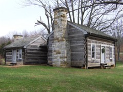 | Cordell Hull Birthplace | building | 1972 | 72001250 |
 | Pickett County Courthouse | building | 1995 | 95000338 |
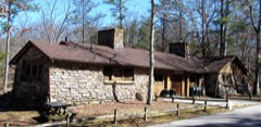 | Pickett State Rustic Park Historic District | district | 1986 | 86002795 |
Every wildfire the federal occurrence database records inside this county: 30 of them, burning about 2,167 acres. 1 started naturally and 18 were recorded as arson. Each settlement page carries the fires within five miles of it.
| Reported cause | Fires |
|---|---|
| Arson/incendiarism | 18 |
| Debris and open burning | 9 |
| Missing data/not specified/undetermined | 2 |
| Natural | 1 |
The five largest, by the area the report gives. 7 of them were set deliberately.
| Date | Cause | Size | Reported by | Name on the report |
|---|---|---|---|---|
| 30 October 2000 | Arson/incendiarism | 652 acres | Tennessee Division of Forestry | not named |
| 25 April 2009 | Arson/incendiarism | 538 acres | Tennessee Division of Forestry | GROUP CAMP FIRE |
| 8 May 2000 | Arson/incendiarism | 274 acres | Tennessee Division of Forestry | not named |
| 1 November 2000 | Arson/incendiarism | 229 acres | Tennessee Division of Forestry | not named |
| 16 November 2012 | Arson/incendiarism | 113 acres | Tennessee Division of Forestry | BALD ROCK 12 |
| 7 June 2007 | Arson/incendiarism | 93 acres | Tennessee Division of Forestry | POWER LINE FIRE |
| 21 October 2010 | Debris and open burning | 53 acres | Tennessee Division of Forestry | 52 MARKET |
| 7 June 2007 | Arson/incendiarism | 49 acres | Big South Fork National River and Recreation Area | THOMPSON CREEK |
Every settlement page carries the fires within five miles of it - see the settlement index below.
The NOAA Storm Events Database holds 99 reports for this county, causing 5 deaths, 11 injuries and about $13,330,000 in recorded property damage. Each settlement page carries the reports that name it.
| Kind of event | Reports |
|---|---|
| Thunderstorm Wind | 57 |
| Hail | 27 |
| Tornado | 6 |
| Flash Flood | 6 |
| Funnel Cloud | 2 |
| Flood | 1 |
The most serious of them, by death, then injury, then recorded damage. The accounts are quoted exactly as the forecast office filed them.
| When | Event | Place named | Harm | What the report says |
|---|---|---|---|---|
| April 1974 | Tornado (F4) | not stated | 5 killed, 6 hurt, $2,500,000 | no account filed |
| April 1998 | Tornado (F3) | Byrdstown | 4 hurt, $10,000,000 | 40 homes and 22 mobile homes were destroyed from this tornado. 95% of the trees were destroyed in the path of the tornado. 45 utility poles were blown down. 100 barns were destroyed, 2 green houses were heavily damaged, and there was damage to fences and pasture land. There were 4 people injured, but they were treated and released. |
| May 1996 | Thunderstorm Wind | Static | 1 hurt, $100,000 | no account filed |
| July 2015 | Thunderstorm Wind | Boom | $100,000 | Strong to severe winds associated with the rear flank downdraft of a supercell blew down numerous trees across southern Pickett County. Several trees were blown down on Hill Cemetary Road, and another tree fell and blocked Cherry Tree Lane near the Oak Grove Cemetary. A barn was damaged at the south end of Tompkins Lane. A tree fell on a home at 525 Tallman Lane causing significant damage, and another tree fell on a cabin on Eastport Road crushing part of the building. A marina broke away from shore at East Port Marina causing minor damage. |
| February 2011 | Thunderstorm Wind | Chanute | $100,000 | A Microburst resulted in snapped and uprooted trees, with a farm straddling the state line receiving the most significant damage. A carport was destroyed and blown away, and a barn was completely destroyed. The damage path was approximately two miles long and 100 yards wide. |
| August 2003 | Flash Flood | Countywide | $100,000 | Newspaper story about heavy rains causing several roads to be closed in Pickett County. The road superintendent estimated damage to roads to be $100,000. Several businesses, and even the courthouse in Byrdstown, had up to 6 inches of standing water inside of them. There was one estimate of 7 inches of rain in a few hours. |
| May 2024 | Thunderstorm Wind | Byrdstown | $75,000 | NWS storm survey found scattered trees were blown down across central Pickett and northern Overton Counties, including on Jolley Road, Iron Creek Road, C Parker Road, Raymond Road, Keisling Ridge Road. A barn was destroyed on Hatcher Hall Road. Winds were estimated up to 70 mph. Damages are a rough estimate. |
| May 2024 | Thunderstorm Wind | Travisville | $75,000 | NWS storm survey found a large 2.5 mile wide by 7 mile long downburst with embedded stronger microbursts that blew down hundreds of trees across northeast Fentress and eastern Pickett Counties, especially in Pickett State Park and Big South Fork Recreation Area. The park was temporarily closed due to all roads being blocked by downed trees. Max winds were estimated up to 85 mph. Damages are a rough estimate. |
| February 2020 | Flash Flood | Eastport | $25,000 | Eastport Marina was heavily damaged by flash flooding on the Obey River with several boats washed downstream and lost. |
| May 2012 | Thunderstorm Wind | Byrdstown | $25,000 | Some trees were downed across the county. |
| May 1986 | Tornado (F0) | not stated | $25,000 | no account filed |
| December 2021 | Tornado (EF0) | Midway | $20,000 | An EF0 tornado touched down near the Monroe community east of Garrett Town Lane and moved eastward, blowing down a few trees. It crossed Highway 111 causing damage to fencing around the recycling plant and downed several more trees. As it continued east, the tornado strengthened, blowing down dozens of trees and destroying several outbuildings along Bethsadia Road, Ester Jones Road, and Big Hollow Road. Debris was blown hundreds of yards away along this portion of the path. The tornado lifted near Dale Hollow Lake. This tornado is the first December tornado on record for Pickett County. |
| June 1997 | Thunderstorm Wind | Byrdstown | $20,000 | 2 homes received damaged when 2 trees fell on them. |
| May 2020 | Thunderstorm Wind | Byrdstown | $19,500 | Numerous trees and power lines were blown down across Pickett County. |
| May 2024 | Thunderstorm Wind | Byrdstown | $15,000 | Severe thunderstorm winds downed several trees across Pickett County. Damages are a rough estimate. |
| July 2022 | Thunderstorm Wind | Byrdstown | $15,000 | Numerous trees and a few power poles were blown down across Pickett County. |
| February 2009 | Thunderstorm Wind | Byrdstown | $12,000 | Numerous trees were blown down in the area. |
| July 2015 | Tornado (EF0) | Oak Grove | $10,000 | An EF0 tornado touched down on Dale Hollow Lake south of Byrdstown then moved southeast across far southern Pickett County into western Fentress County before lifting southwest of Jamestown. Several trees were snapped and uprooted along Winningham Road and Robbinstown Road before the tornado moved into Fentress County. Photos of the tornado were taken from Midway and Alpine, and the tornado was reportedly visible from Moodyville. |
| May 2013 | Thunderstorm Wind | Byrdstown | $10,000 | A trained spotter reported a tree down on a house on Main Street in Byrdstown. Power outages were also reported in the city. |
| June 2011 | Thunderstorm Wind | Green Brier | $10,000 | A roof was blown off a mobile home and numerous trees were knocked down near the Green Brier community. |
| May 2009 | Thunderstorm Wind | Byrdstown | $10,000 | Trees were reported down in Byrdstown. |
| June 2009 | Thunderstorm Wind | Green Brier | $10,000 | Twelve inch trees were down in the Green Briar Community. |
| April 2006 | Hail | Byrdstown | $10,000 | Golf ball size hail reported at Dale Hollow Lake. Several cars were damaged. |
| June 1997 | Thunderstorm Wind | Byrdstown | $10,000 | Trees were uprooted and caused damage at the Star Point Marina. |
| June 2019 | Thunderstorm Wind | Byrdstown | $5,000 | Trees and power lines were blown down across Pickett County. |
| July 2016 | Thunderstorm Wind | Boom | $5,000 | Trees reported down all across southwest Pickett County. |
| May 2005 | Thunderstorm Wind | Byrdstown | $5,000 | Park Ranger at Pickett State Park reported 300-400 oak trees blown down. A newspaper account reported one tree landed on and crushed a rental car of one of the park's guests. Several trees were blown across Highway 154 along a one mile stretch from the park entrance south. The falling trees took out 3 power poles along Highway 154 and a lengthy stretch of power lines which feeds the group camp and other park areas. Pickett State Park was closed for cleanup until May 25, in time for the Memorial Day weekend. |
| July 2003 | Thunderstorm Wind | Byrdstown | $5,000 | Newspaper article about a large tree being blown down and falling on a house on Olympus Drive. Also, high winds blew the church steeple off the top of the Midway Christian Church. |
| June 2011 | Thunderstorm Wind | Byrdstown | $3,000 | Several trees were blown down. |
| July 2016 | Thunderstorm Wind | Sunset | $2,000 | A tree and power line were blown down in the yard of a home on Hassler Lane in Byrdstown. |
| May 1995 | Thunderstorm Wind | Byrdstown | $2,000 | A few trees and power lines were knocked down. Cannon County Pleasant Ridge Woodbury,14,0400CST,,,0,0,0.02M,0,Thunderstorm Winds The county jail suffered roof damage. A dentist's office was damaged. Several trees were uprooted. |
| May 2022 | Thunderstorm Wind | Star Pt | $1,000 | A tree was blown down along West Main Street in Byrdstown. |
| December 2021 | Thunderstorm Wind | Byrdstown | $1,000 | A large tree was blown down near Pickett County High School. |
| June 2018 | Thunderstorm Wind | Parker | $1,000 | A tree was blown down at 1750 Parker Road. |
| June 2009 | Thunderstorm Wind | Byrdstown | $1,000 | One tree was reported downed in the Clark Mountain Community. |
| August 2006 | Thunderstorm Wind | Countywide | $1,000 | A few trees fell on power lines around the county causing 800 Pickett Countians to be without power.One of these trees fell on Hassler Lane which is about 2 miles northwest of Byrdstown. |
| November 2004 | Flash Flood | Countywide | $1,000 | Some roads had high water on them around the county. |
| July 1994 | Thunderstorm Wind | Byrdstown | $500 | A few trees were knocked down. |
| June 2023 | Hail | Jones Chapel | - | Estimated penny size hail was reported northwest of Byrdstown. |
| June 2023 | Hail | Byrdstown | - | Estimated golf ball size hail fell from a severe thunderstorm in Byrdstown. |
| February 2019 | Flood | Barnes | - | Jolly Creek Road was flooded and closed. |
| July 2018 | Hail | Byrdstown | - | Facebook photos showed dime to quarter size hail in Byrdstown. |
| July 2018 | Hail | Cedar Hill | - | Facebook photos showed quarter size hail in the Cedar Grove area. |
| May 2018 | Funnel Cloud | Sunset | - | Numerous Facebook photos and videos showed a series of three waterspouts developed over an arm of Dale Hollow Lake next to the Sunset Marina & Resort near the Highway 111 bridge south of Byrdstown. No damage was reported as the waterspouts quickly dissipated as they neared the marina and shoreline. These unusual waterspouts appeared to form as the updraft of a thunderstorm slowly propagated southwestward and interacted with an outflow boundary which was roughly parallel to that portion of Dale Hollow Lake. |
| December 2016 | Hail | Red Hill | - | Quarter size hail fell on Obey River Bridge in Byrdstown. |
| April 2010 | Funnel Cloud | Byrdstown | - | A funnel cloud was reported in Byrdstown. |
| June 2010 | Hail | Midway | - | Residents at 3098 Old Livingston Road observed nickel size hail. |
| February 2009 | Hail | Smyrna | - | Emergency Manager reported quarter size hail on Highway 111 and Pendergrass Road. |
| February 2009 | Hail | Midway | - | CoCoRAHS Observer reported one inch hail. |
| May 2009 | Hail | Byrdstown | - | Penny size hail was reported in Byrdstown. |
| April 2005 | Hail | Byrdstown | - | Sheriff's office reported dime to nickel size hail. |
| April 2005 | Hail | Byrdstown | - | Half dollar size hail reported. |
| May 2005 | Hail | Byrdstown | - | Park Ranger reported penny size hail. |
| June 2005 | Thunderstorm Wind | Byrdstown | - | Sheriff's office reported a small tree was blown down on Clark Mountain Rd. |
| June 2005 | Thunderstorm Wind | Static | - | Sheriff's office reported a small tree was blown down. |
| May 2004 | Thunderstorm Wind | Byrdstown | - | Trees and power lines were down in the southeast part of town. |
| June 2004 | Hail | Byrdstown | - | Nickel size hail observed. |
| March 2003 | Thunderstorm Wind | Byrdstown | - | Trained spotter reported several boats destroyed. |
| March 2003 | Hail | Byrdstown | - | Quarer size hail reported by trained spotter. |
| March 2003 | Flash Flood | Countywide | - | TDOT reported minor flooding on secondary roads across the county. |
The Survey's mineral resources record lists 10 workings inside this county. 2 still produce and 8 are closed or unrecorded. Each settlement page carries the workings within five miles of it.
| Commodity | Workings |
|---|---|
| Zinc | 4 |
| Barium-Barite, Zinc | 2 |
| Stone, Crushed/Broken, Limestone, General | 1 |
| Copper, Sulfur-Pyrite, Zinc | 1 |
| Stone, Crushed/Broken | 1 |
| Copper | 1 |
| Sulfur, Zinc | 1 |
The least common of them first, because a county's hundredth gravel pit says nothing its first ten did not.
| Where | Site | Commodity | Status | Recorded |
|---|---|---|---|---|
| Hagan Prospect | Copper, Sulfur-Pyrite, Zinc | Occurrence | Chalcopyrite, Pyrite, Sphalerite | |
| Hagan Prospect | Copper, Sulfur, Zinc | Occurrence | ||
| Pickett Co. Hwy. Dept. Pit No. 164 | Stone, Crushed/Broken, Limestone, General | Producer | 1933 | |
| Pickett County Highway Dept. Quarry | Stone, Crushed/Broken | Producer | ||
| Heard Prospect | Barium-Barite, Zinc | Occurrence | Barite, Sphalerite | |
| Heard Prospect | Barium-Barite, Zinc | Past Producer | ||
| Deep Well-Sphalerite Occurrence | Zinc | Occurrence | Sphalerite | |
| Deep Well-Sphalerite Occurrence | Zinc | Occurrence | Sphalerite | |
| Deep Well-Sphalerite Occurrence | Zinc | Occurrence | ||
| Deep Well-Sphalerite Occurrence | Zinc | Occurrence |
Named settlements recorded in the Geographic Names Information System, each with the topographic sheets covering it. Villages, hamlets and abandoned places alike. Each is shown with the nearest named watercourse or landform and the survey quadrangle it falls on.
District 3 · 38577 · Near Falling Waters Hollow · Moodyville quadrangle
11 sheets, 1929 to 1985
District 3 · 38577 · Near Falling Waters Hollow · Moodyville quadrangle
11 sheets, 1929 to 1985
No longer a settlement
District 3 · 38577 · On Wright Branch · Moodyville quadrangle
11 sheets, 1929 to 1985
The vanished settlements of Pickett County: the places named above that are no longer on the map.