 Block
From the record
5 National Register listings published here, 1 of them a National Historic Landmark.
Sources: the National Register database, National Park Service
112 topographic sheets cover 50 settlements here, and 5 properties are on the National Register of Historic Places.
5 National Register listings published here, 1 of them a National Historic Landmark.
Sources: the National Register database, National Park Service
Every property in this county listed on the National Register of Historic Places, with the year it was listed and the federal nomination document.
| Photograph | Property | Type | Listed | Reference |
|---|---|---|---|---|
 | Broyles-Darwin House | building | 1997 | 97000779 |
| First Avenue Methodist Episcopal Church | building | 2020 | 100005790 | |
 | Rhea County Courthouse | building | 1972 | 72001251 |
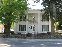 | Dr. Walter Thomison House | building | 1997 | 97001140 |
| Watts Barr Hydroelectric Project | district | 2017 | 100001474 |
Every wildfire the federal occurrence database records inside this county: 703 of them, burning about 7,705 acres. 9 started naturally and 233 were recorded as arson. Each settlement page carries the fires within five miles of it.
| Reported cause | Fires |
|---|---|
| Debris and open burning | 320 |
| Arson/incendiarism | 233 |
| Missing data/not specified/undetermined | 50 |
| Equipment and vehicle use | 31 |
| Recreation and ceremony | 15 |
| Smoking | 13 |
| Misuse of fire by a minor | 12 |
| Natural | 9 |
| Other causes | 7 |
| Power generation/transmission/distribution | 7 |
| Railroad operations and maintenance | 5 |
| Fireworks | 1 |
The five largest, by the area the report gives. Five of them were set deliberately.
| Date | Cause | Size | Reported by | Name on the report |
|---|---|---|---|---|
| 4 November 2001 | Arson/incendiarism | 924 acres | Tennessee Division of Forestry | not named |
| 18 November 2001 | Arson/incendiarism | 620 acres | Tennessee Division of Forestry | not named |
| 10 November 2001 | Arson/incendiarism | 542 acres | Tennessee Division of Forestry | not named |
| 20 October 2000 | Arson/incendiarism | 285 acres | Tennessee Division of Forestry | not named |
| 26 May 2007 | Smoking | 268 acres | Tennessee Division of Forestry | GRANDVIEW |
| 10 April 2017 | Arson/incendiarism | 188 acres | Tennessee Division of Forestry | NEWMANS LANE |
| 12 September 2002 | Debris and open burning | 181 acres | Tennessee Division of Forestry | not named |
| 27 March 1999 | Debris and open burning | 175 acres | Tennessee Division of Forestry | not named |
Every settlement page carries the fires within five miles of it - see the settlement index below.
The NOAA Storm Events Database holds 333 reports for this county, causing 1 death, 6 injuries and about $13,629,150 in recorded property damage. Each settlement page carries the reports that name it.
| Kind of event | Reports |
|---|---|
| Thunderstorm Wind | 230 |
| Hail | 65 |
| Flash Flood | 20 |
| Flood | 10 |
| Tornado | 4 |
| Funnel Cloud | 2 |
| Lightning | 1 |
| Heavy Rain | 1 |
The most serious of them, by death, then injury, then recorded damage. The accounts are quoted exactly as the forecast office filed them.
| When | Event | Place named | Harm | What the report says |
|---|---|---|---|---|
| December 2015 | Flash Flood | Dayton | 1 killed, $15,000 | A section of Hwy 30 crossing Rattan Creek near Dayton washed out. Two vehicles were washed away, with rescues required. One fatality. |
| March 1998 | Thunderstorm Wind | Countywide | 4 hurt, $25,000 | no account filed |
| April 2011 | Tornado (EF4) | Morgan Spgs | 2 hurt, $2,000,000 | New Harmony Tornado. This tornado continued its destuctive path into Rhea County. The 190 mph wind destroyed 19 roofs and 21 homes had damage. Trees and powerlines were also downed. Two people were injured.||This tornado had a total path length of 40.2 miles and was responsible for four deaths in Bledsoe County. |
| May 2003 | Flash Flood | Countywide | $8,370,000 | Widespread flooding, road closures, damage, evacuations. |
| July 2010 | Thunderstorm Wind | Roddy | $1,000,000 | High wind flipped a boat dock at the Arrowhead Marina onto an adjacent boat dock.|Twenty five boats were damaged during the event and a HAZMAT team arrived at the scene to contain gasoline and oil leaks from the damaged boats. |
| July 2005 | Lightning | Dayton | $400,000 | no account filed |
| December 2015 | Flood | Dayton | $250,000 | Two homes...an apartment building...schools...and a few businesses were flooded across the county. |
| June 1983 | Tornado (F1) | not stated | $250,000 | no account filed |
| March 2004 | Flash Flood | Graysville | $100,000 | A bridge was washed out on Aslinger Circle in Graysville. Garrison Lane on Grandview Mountain was also, washed out and, hence, became impassable. Pikeville Road became impassable due to high water. |
| May 2013 | Flash Flood | Dayton | $50,000 | Significant flooding of a church and a local corner market on Dayton Mountain Hwy. Debris from church rushed downstream. TV media covered. |
| July 1999 | Thunderstorm Wind | Spring City | $50,000 | no account filed |
| July 2006 | Thunderstorm Wind | Spring City | $40,000 | no account filed |
| October 2001 | Thunderstorm Wind | Evensville | $35,000 | Storage buildings blown over. |
| July 2006 | Thunderstorm Wind | Countywide | $35,000 | no account filed |
| July 2002 | Thunderstorm Wind | Washington | $35,000 | no account filed |
| April 2011 | Thunderstorm Wind | Spring City | $25,000 | Law enforcement personnel reported numerous trees downed and damage a home by thunderstorm wind in Spring City. |
| July 2002 | Thunderstorm Wind | Spring City | $25,000 | no account filed |
| June 2010 | Thunderstorm Wind | Spring City | $20,000 | Utility company personnel reported numerous trees and powerlines downed by thunderstorm winds across the northern portions of the county. |
| February 2009 | Thunderstorm Wind | Morgantown | $20,000 | Law enforcement personnel reported a tree downed by thunderstorm winds fell on a school bus in Dayton. |
| August 2007 | Thunderstorm Wind | Dayton | $20,000 | The Herald News in Dayton reported a section on roof from a barn and apartment near Dayton were damaged by winds. Numerous trees were also reported downed by thunderstorm winds in the Dayton area. |
| August 2005 | Thunderstorm Wind | Dayton | $20,000 | Several trees just west of Dayton. |
| July 2005 | Thunderstorm Wind | Dayton | $20,000 | no account filed |
| May 2004 | Thunderstorm Wind | Spring City | $20,000 | no account filed |
| July 2004 | Thunderstorm Wind | Spring City | $20,000 | no account filed |
| August 2002 | Thunderstorm Wind | Spring City | $20,000 | no account filed |
| May 1996 | Thunderstorm Wind | Countywide | $20,000 | no account filed |
| July 2006 | Thunderstorm Wind | Spring City | $18,000 | no account filed |
| July 2004 | Thunderstorm Wind | Dayton | $17,000 | no account filed |
| August 2014 | Thunderstorm Wind | Dayton | $15,000 | Law enforcement personnel reported numerous downed by thunderstorm wind in Dayton. |
| February 2011 | Thunderstorm Wind | Dayton | $15,000 | Law enforcement personnel reported two trees and numerous powerlines downed by thunderstorm wind in Dayton. |
| April 2009 | Thunderstorm Wind | Graysville | $15,000 | The newspaper reported a several trees and powerlines downed by thunderstorm winds in Graysville. In addition, a few homes sustained damage. |
| April 2007 | Thunderstorm Wind | Morgantown | $15,000 | A few trees were reported down across the southern half of the county. |
| April 2007 | Thunderstorm Wind | Morgantown | $15,000 | A few trees were reported down in Dayton and Graysville. |
| June 2007 | Thunderstorm Wind | Dayton | $15,000 | A few trees and powerlines were downed by thunderstorm winds in Dayton. |
| October 2006 | Thunderstorm Wind | Morgantown | $15,000 | Several trees and powerlines down countywide. |
| March 2006 | Thunderstorm Wind | Spring City | $15,000 | no account filed |
| November 2005 | Thunderstorm Wind | Dayton | $15,000 | no account filed |
| July 2004 | Thunderstorm Wind | Spring City | $15,000 | no account filed |
| May 2003 | Thunderstorm Wind | Countywide | $15,000 | no account filed |
| June 2003 | Thunderstorm Wind | Dayton | $15,000 | no account filed |
| June 2002 | Thunderstorm Wind | Dayton | $15,000 | no account filed |
| June 2010 | Thunderstorm Wind | Spring City | $12,000 | Law enforcement personnel reported several trees and powerlines downed by thunderstorm winds near the junction of Highway 302 and Wolf Creek Road. |
| April 2006 | Thunderstorm Wind | Spring City | $12,000 | Several trees down in Spring City. |
| June 2006 | Thunderstorm Wind | Spring City | $12,000 | Several trees and powerlines down in Spring City. |
| July 2023 | Flash Flood | Spring City | $10,000 | Flooding of some homes and garages occurred in Spring City. |
| June 2014 | Flash Flood | Dayton | $10,000 | Law enforcement reported a couple of roads covered by water from thunderstorms in Dayton. |
| March 2012 | Tornado (EF0) | Dayton Arpt | $10,000 | This tornado formed east of Dayton and moved to the east-northeast. It destroyed one shed, caused light to moderate damage to four barns, and knocked down several trees along its path through rural areas, south of Highway 30. The maximum wind was estimated at 80 mph. |
| April 2011 | Tornado (EF1) | Ideal Vly | $10,000 | A NWS storm survey reported an EF1 tornado touched down near Spring City. It formed west of city and and tracked the northern portions of the city where it dissipated. It had a path width of 75 yards and a path length of 1.5 miles. The 90 mph wind downed a few trees. |
| June 2010 | Flash Flood | Dayton | $10,000 | The public reported an estimated 6 to 7 inches of rain fell from thunderstorms in a 1 1/2 hour period off of Liberty Hill Road. |
| October 2010 | Thunderstorm Wind | Dayton | $10,000 | Law Enforcement personnel reported numerous trees downed by thunderstorm wind countywide. |
| June 2009 | Thunderstorm Wind | Dayton | $10,000 | Law enforcement personnel reported a few trees and powerlines downed by thunderstorm winds in the Dayton area and countywide. |
| February 2008 | Thunderstorm Wind | Spring City | $10,000 | The highway department reported a few trees down on Hwy 68 near Spring City. |
| June 2007 | Thunderstorm Wind | Grandview | $10,000 | Thunderstorm winds downed several trees in Grandview. |
| June 2007 | Thunderstorm Wind | Dayton | $10,000 | Thunderstorm wind downed several trees in Dayton. |
| June 2007 | Thunderstorm Wind | Spring City | $10,000 | Thunderstorm winds downed a few trees across the north half of the county. |
| June 2007 | Thunderstorm Wind | Spring City | $10,000 | Thunderstorm winds downed a few trees at Jackson Island Campground in Spring City. |
| August 2006 | Thunderstorm Wind | Graysville | $10,000 | Several trees down in and around Graysville. |
| August 2005 | Thunderstorm Wind | Spring City | $10,000 | Two trees and powerlines down near Spring City. |
| July 2001 | Thunderstorm Wind | Grandview | $10,000 | A couple of trees down on houses. |
| May 1995 | Thunderstorm Wind | Dayton | $10,000 | Numerous trees and power lines were knocked down. |
The Survey's mineral resources record lists 4 workings inside this county. All of them still produce. Each settlement page carries the workings within five miles of it.
| Commodity | Workings |
|---|---|
| Stone, Crushed/Broken | 2 |
| Stone, Crushed/Broken, Limestone, General | 1 |
| Sand and Gravel, Construction | 1 |
The least common of them first, because a county's hundredth gravel pit says nothing its first ten did not.
| Where | Site | Commodity | Status | Recorded |
|---|---|---|---|---|
| Piney Creek Mine | Sand and Gravel, Construction | Producer | ||
| Rhea County Limestone | Stone, Crushed/Broken, Limestone, General | Producer | Limestone | |
| Old Washington Quarry | Stone, Crushed/Broken | Producer | ||
| Rhea County Limestone | Stone, Crushed/Broken | Producer |
Named settlements recorded in the Geographic Names Information System, each with the topographic sheets covering it. Villages, hamlets and abandoned places alike. Each is shown with the nearest named watercourse or landform and the survey quadrangle it falls on.
District 2 · 37381 · On Bumbee Creek · Pennine quadrangle
21 sheets, 1887 to 1981
No longer a settlement
District 8 · 37321 · On Little Richland Creek · Graysville quadrangle
28 sheets, 1888 to 1988
District 6 · 37321 · Near Lone Mountain · Morgan Springs quadrangle
24 sheets, 1892 to 1981
District 9 · 37321 · On Paine Creek · Morgan Springs quadrangle
24 sheets, 1892 to 1981
District 1 · 37381 · Near Gravelly Hollow · Ten Mile quadrangle
22 sheets, 1887 to 1981
District 4 · 37332 · On Yarborough Branch · Evensville quadrangle
24 sheets, 1887 to 1981
District 3 · 37381 · Near Doc Smith Island · Spring City quadrangle
24 sheets, 1887 to 1981
District 1 · 37381 · On Iron Hill · Ten Mile quadrangle
22 sheets, 1887 to 1981
No longer a settlement
District 2 · 37381 · On Laurel Ford Branch · Spring City quadrangle
24 sheets, 1887 to 1981
District 1 · 37381 · On Toestring Branch · Spring City quadrangle
24 sheets, 1887 to 1981
District 6 · 37321 · Near Dutchmans Knob · Morgan Springs quadrangle
24 sheets, 1892 to 1981
District 6 · 37321 · Near Maley Hollow · Graysville quadrangle
28 sheets, 1888 to 1988
District 5 · 37321 · On Little Richland Creek · Morgan Springs quadrangle
24 sheets, 1892 to 1981
District 4 · 37321 · On Thorny Branch · Evensville quadrangle
24 sheets, 1887 to 1981
District 4 · 37332 · On Board Tree Branch · Morgan Springs quadrangle
24 sheets, 1892 to 1981
District 2 · 37381 · Near Toestring Valley · Spring City quadrangle
24 sheets, 1887 to 1981
District 2 · 37381 · On Wolf Creek · Spring City quadrangle
24 sheets, 1887 to 1981
No longer a settlement
District 1 · 37381 · Near Cawood Hollow · Spring City quadrangle
24 sheets, 1887 to 1981
District 5 · 37321 · On Little Richland Creek · Evensville quadrangle
24 sheets, 1887 to 1981
District 2 · 37381 · On Cardwell Branch · Spring City quadrangle
24 sheets, 1887 to 1981
District 1 · 37381 · On Rector Branch · Ten Mile quadrangle
22 sheets, 1887 to 1981
The vanished settlements of Rhea County: the places named above that are no longer on the map.