 Block
From the record
4 National Register listings published here.
Sources: the National Register database, National Park Service
54 topographic sheets cover 26 settlements here, and 4 properties are on the National Register of Historic Places.
4 National Register listings published here.
Sources: the National Register database, National Park Service
Every property in this county listed on the National Register of Historic Places, with the year it was listed and the federal nomination document.
| Photograph | Property | Type | Listed | Reference |
|---|---|---|---|---|
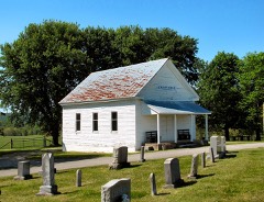 | Crain Hill School and Church | building | 1985 | 85000622 |
| Higginbotham Turnpike | site | 2020 | 100005368 | |
| Rocky River Crossing and Road | structure | 2006 | 06001038 | |
| Rocky River Crossing and Road | structure | 2006 | 06001038 |
Every wildfire the federal occurrence database records inside this county: 683 of them, burning about 15,867 acres. 4 started naturally and 446 were recorded as arson. Each settlement page carries the fires within five miles of it.
| Reported cause | Fires |
|---|---|
| Arson/incendiarism | 446 |
| Debris and open burning | 140 |
| Missing data/not specified/undetermined | 66 |
| Equipment and vehicle use | 7 |
| Recreation and ceremony | 7 |
| Natural | 4 |
| Other causes | 4 |
| Smoking | 3 |
| Power generation/transmission/distribution | 3 |
| Fireworks | 2 |
| Misuse of fire by a minor | 1 |
The five largest, by the area the report gives. Every one of them was set deliberately.
| Date | Cause | Size | Reported by | Name on the report |
|---|---|---|---|---|
| 10 April 1999 | Arson/incendiarism | 2,480 acres | Tennessee Division of Forestry | not named |
| 4 November 2001 | Arson/incendiarism | 1,050 acres | Tennessee Division of Forestry | not named |
| 11 April 1999 | Arson/incendiarism | 880 acres | Tennessee Division of Forestry | not named |
| 4 November 2001 | Arson/incendiarism | 774 acres | Tennessee Division of Forestry | not named |
| 25 April 2009 | Arson/incendiarism | 609 acres | Tennessee Division of Forestry | SPIKE BUCK RD |
| 1 April 2015 | Arson/incendiarism | 601 acres | Tennessee Division of Forestry | GREEN FIELDS FIRE |
| 26 April 2009 | Arson/incendiarism | 450 acres | Tennessee Division of Forestry | LOWER FORD RD |
| 12 March 2007 | Arson/incendiarism | 420 acres | Tennessee Division of Forestry | HWY 30 |
Every settlement page carries the fires within five miles of it - see the settlement index below.
The NOAA Storm Events Database holds 104 reports for this county, causing 1 death, 1 injury and about $1,004,100 in recorded property damage. Each settlement page carries the reports that name it.
| Kind of event | Reports |
|---|---|
| Thunderstorm Wind | 49 |
| Hail | 30 |
| Flash Flood | 18 |
| Lightning | 3 |
| Tornado | 2 |
| Flood | 2 |
The most serious of them, by death, then injury, then recorded damage. The accounts are quoted exactly as the forecast office filed them.
| When | Event | Place named | Harm | What the report says |
|---|---|---|---|---|
| October 2021 | Flash Flood | Lonewood | 1 killed, 1 hurt, $5,000 | A car with 2 occupants was swept off Mooneyham Lonewood Road. The passenger, a 67 year old male, died and the female driver was injured. |
| August 2023 | Thunderstorm Wind | Mooneyham | $500,000 | Satellite imagery along with damage photos indicate a large and very damaging 10 mile wide downburst struck eastern Van Buren County. Scattered trees were snapped and uprooted in this large downburst with winds estimated from 60 to 75 mph. Within the downburst area, a smaller but much more damaging 1.5 mile wide microburst blew down thousands of trees from western Fall Creek Falls State Park eastward to south of Saratoga Springs. Numerous roads were blocked by falling trees in this area, with some trees falling onto buildings. Winds in the microburst were estimated up to 95 mph. This resulted in numerous trees falling on cars in the park and trapping multiple people. Multiple campers were also damaged, and widespread power outages forced the park to close. Damages are a rough estimate. |
| May 1997 | Lightning | Spencer | $100,000 | Electric company reported lightning damaged a transformer near the Baker Boyd Subdivsion in the Turkey Scratch area near Spencer. |
| November 2002 | Tornado (F2) | Spencer | $75,000 | EMA reported a frame house was demolished at intersection of Highway 111 and Highway 30. |
| June 2009 | Flash Flood | Bone Cave | $50,000 | Roads flooded throughout the county. Landslide on 30 East out of Spencer. Road was blocked. |
| June 2018 | Thunderstorm Wind | Phiferes | $25,000 | Fall Creek Falls State Park manager estimated one to two hundred trees were blown down across the park with three cabins and several campers and vehicles damaged from fallen trees. |
| June 2009 | Flash Flood | Bone Cave | $25,000 | Several roads were flooded throughout Van Buren County. Newspaper reported that water ran over State Highway 30 east of Spencer, causing the roadway to be closed|for nearly two hours until the Tennessee Department of Transportation and other volunteers could clean ditches and divert the water which was crossing the roadway nearly a foot deep. The water was washing rocks and other debris into the road, causing at least one vehicle to sustain a flat tire when it was driven through the area. |
| June 2009 | Thunderstorm Wind | Spencer | $25,000 | Small trees were reported down county wide. |
| May 2020 | Thunderstorm Wind | Spencer | $21,300 | Numerous trees and power lines were blown down across Van Buren County. |
| March 2017 | Thunderstorm Wind | Phiferes | $20,000 | Facebook reports and photos showed numerous trees were blown down at Fall Creek Falls with many falling onto campers and vehicles. No injuries were reported. |
| August 2023 | Thunderstorm Wind | Spencer | $15,000 | Severe thunderstorm winds downed several trees in Spencer. Damages are a rough estimate. |
| July 2012 | Thunderstorm Wind | White Hill | $15,000 | Trees were downed across the western portion of county. |
| July 2022 | Lightning | Piney | $10,000 | A Facebook photo from the Piney Fire Department indicated lightning struck an outbuilding on Old Highway 111 and the resulting fire destroyed it. |
| June 2016 | Thunderstorm Wind | Spencer | $10,000 | Several trees were blown down throughout Van Buren County blocking roadways, and a few power lines were also downed. |
| January 2013 | Thunderstorm Wind | Spencer | $10,000 | A few trees were downed across the county. |
| July 2012 | Thunderstorm Wind | Phiferes | $10,000 | Several trees were downed at Fall Creek Falls State Park. |
| June 2009 | Flash Flood | Mooneyham | $10,000 | Roads flooded throughout county with lots of road closures and detours reported. |
| April 1998 | Hail | Piney | $10,000 | Local law enforcement reported baseball size hail. The hail knocked out car windows and damaged roofs. |
| April 1996 | Thunderstorm Wind | Countywide | $10,000 | no account filed |
| April 2023 | Thunderstorm Wind | Piney | $5,000 | Severe thunderstorm winds uprooted two large oak trees along Old State Highway 111 about 6 miles away from Fall Creek Falls State Park southern entrance. Damages are estimated. |
| June 2019 | Thunderstorm Wind | Spencer | $5,000 | Trees were blown down across Van Buren County. |
| June 2014 | Thunderstorm Wind | Spencer | $5,000 | Several trees and power lines were blown down in and around Spencer. |
| January 2010 | Flash Flood | Mooneyham | $5,000 | Sheriffs office reported minor flooding along Highway 30 East toward Fall Creek Falls State Park. |
| July 2004 | Flash Flood | Countywide | $5,000 | Flooding was reported on Highway 30 east and highway 284 at 2 PM CST. By 330 PM CST the north end of Fall Creek Falls State park was flooded and impassable according to reports by the Forest Service. |
| May 1995 | Tornado (F0) | Fall Creek Falls | $5,000 | A tornado briefly touched at the Fall Creek Falls State State Park. Several power lines were knocked down. |
| June 1995 | Thunderstorm Wind | Spencer | $5,000 | Several power and telephone lines were blown down. |
| June 1994 | Thunderstorm Wind | Falls Creek State Par | $5,000 | Numerous trees were knocked down. |
| May 1993 | Thunderstorm Wind | Fall Creek | $5,000 | Numerous trees were blown down. |
| January 2022 | Thunderstorm Wind | Phiferes | $3,000 | Multiple trees were reportedly blown down in Fall Creek Falls State Park. |
| December 2013 | Thunderstorm Wind | Spencer | $3,000 | A few large trees were blown down across Van Buren County. |
| July 2007 | Lightning | Spencer | $2,000 | Lightning struck a utility building on RT Davis Rd. It caught fire, and the building and its contents were completely destroyed. The building housed antiques and flammable materials that were used to refurbish the antiques. |
| June 2021 | Thunderstorm Wind | Mooneyham | $1,000 | Large tree down on SR 285. |
| March 2020 | Thunderstorm Wind | Bone Cave | $1,000 | A very large tree was uprooted. |
| August 2005 | Flash Flood | Spencer | $1,000 | Law enforcement reported a rock slide on Highway 30. |
| April 1998 | Flash Flood | Cummingsville | $1,000 | The sheriff's offcie reported a truck was temporarily swept off the road due to high water. He sustained minor damage to front bumper. |
| July 2008 | Thunderstorm Wind | Spencer | $500 | Trees were blown down around town. |
| March 2008 | Thunderstorm Wind | Spencer | $200 | Tree was blown down near Fall Creek Falls State Park. |
| June 1995 | Hail | Spencer | $100 | Several power and telephone lines were blown down. |
| May 2025 | Hail | Mooneyham | - | Estimated ping pong size hail was reported near Spencer from a tornado-warned thunderstorm. |
| July 2024 | Flash Flood | Phiferes | - | Flash flooding reported over several roads in southern Van Buren County. Roads included Old State Highway 111, Howard, Brockdell, and Fall Creek Road. Several pictures received from local emergency manager. Received a couple reports of rainfall over 5 inches in the vicinity, all of which occurred within a 2 hour time frame. Damages are unknown. |
| October 2021 | Flash Flood | Sweetgum | - | Cane Creek Road and Highway 30 near Fall Creek Falls State Park are impassable in some places due to flooding. |
| October 2021 | Flash Flood | Sweetgum | - | Several reports of flash flooding and roads closed throughout eastern Van Buren County, including Park Road near the Rockhouse, and Highway 30E between Van Buren County Head Start and Cane Creek Road. |
| March 2020 | Thunderstorm Wind | Bone Cave | - | A tree fell through a large metal barn. |
| March 2018 | Hail | Phiferes | - | Fall Creek Falls Golf Course reported the ground was covered by nickel to quarter size hail. |
| July 2018 | Hail | Phiferes | - | Quarter size hail was reported at the Fall Creek Falls campground. |
| July 2018 | Hail | Phiferes | - | A Facebook report indicated dime size hail fell in Fall Creek Falls State Park. |
| April 2017 | Flood | Sweetgum | - | Twitter reports indicated Caney Creek was out of its banks along Cane Creek-Cummingsville Road and flooded parts of the roadway. |
| December 2015 | Flood | Bone Cave | - | Minor flooding was reported across Van Buren County. |
| June 2011 | Hail | Cummingsville | - | Golfball size hail reported by public on Hodges Ferry Road. |
| May 2009 | Hail | Spencer | - | Penny size hail was reported in Spencer. |
| April 2006 | Hail | East Central Portion | - | Penny size hail reported at the ranger station at Fall Creek Falls State Park. |
| April 2006 | Thunderstorm Wind | Countywide | - | Minor wind damage around the county. |
| June 2006 | Thunderstorm Wind | Spencer | - | 911 Center reported trees down on Highway 30 west heading toward McMinnville. |
| June 2006 | Hail | Spencer | - | Nickel size hail reported by Park Ranger at Fall Creek Falls State Park. |
| July 2006 | Hail | Spencer | - | Hail about the size of a penny fell at the Sheriff's office in Spencer. |
| September 2006 | Thunderstorm Wind | Bone Cave | - | 911 dispatcher reported a few trees and power lines were down. |
| September 2006 | Hail | Bone Cave | - | 911 dispatcher reported penny size hail. |
| February 2005 | Thunderstorm Wind | Spencer | - | Trees were down across Highway 30 near Spencer. |
| March 2005 | Hail | Spencer | - | Spotter reported golf ball size hail. |
| July 2004 | Thunderstorm Wind | Countywide | - | Numerous trees and power lines were down. |
The Survey's mineral resources record lists 5 workings inside this county. 2 still produce and 3 are closed or unrecorded. Each settlement page carries the workings within five miles of it.
| Commodity | Workings |
|---|---|
| Stone, Crushed/Broken | 3 |
| Zinc | 2 |
The least common of them first, because a county's hundredth gravel pit says nothing its first ten did not.
| Where | Site | Commodity | Status | Recorded |
|---|---|---|---|---|
| Deep Well-Sphalerite Occurrence | Zinc | Occurrence | Sphalerite | |
| Deep Well-Sphalerite Occurrence | Zinc | Occurrence | ||
| Van Buren Co. Highway Dept. Quarry | Stone, Crushed/Broken | Producer | ||
| Van Buren County Hwy. Dept. Pit #394 | Stone, Crushed/Broken | Producer | 1961 | |
| Van Buren Quarry | Stone, Crushed/Broken | Past Producer |
Named settlements recorded in the Geographic Names Information System, each with the topographic sheets covering it. Villages, hamlets and abandoned places alike. Each is shown with the nearest named watercourse or landform and the survey quadrangle it falls on.
District 2 · 38581 · Near Little Mountain · Welchland quadrangle
16 sheets, 1893 to 1981
No longer a settlement
District 2 · 38581 · Near Little Mountain · Welchland quadrangle
16 sheets, 1893 to 1981
District 2 · 38583 · On Cummings Cove Branch · Bald Knob quadrangle
21 sheets, 1892 to 1981
District 5 · 38585 · In Laurel Cove · Welchland quadrangle
16 sheets, 1893 to 1981
No longer a settlement
District 2 · 38581 · Near Moulder Mountain · Welchland quadrangle
16 sheets, 1893 to 1981
District 2 · 38583 · Near Bald Knob · Bald Knob quadrangle
21 sheets, 1892 to 1981
No longer a settlement
The vanished settlements of Van Buren County: the places named above that are no longer on the map.