 Block
From the record
One of 38 National Register listings published here for Sevier County · listed in 2003 · category: Building · built in 1886, Gothic Revival.
Sources: the National Register database, National Park Service
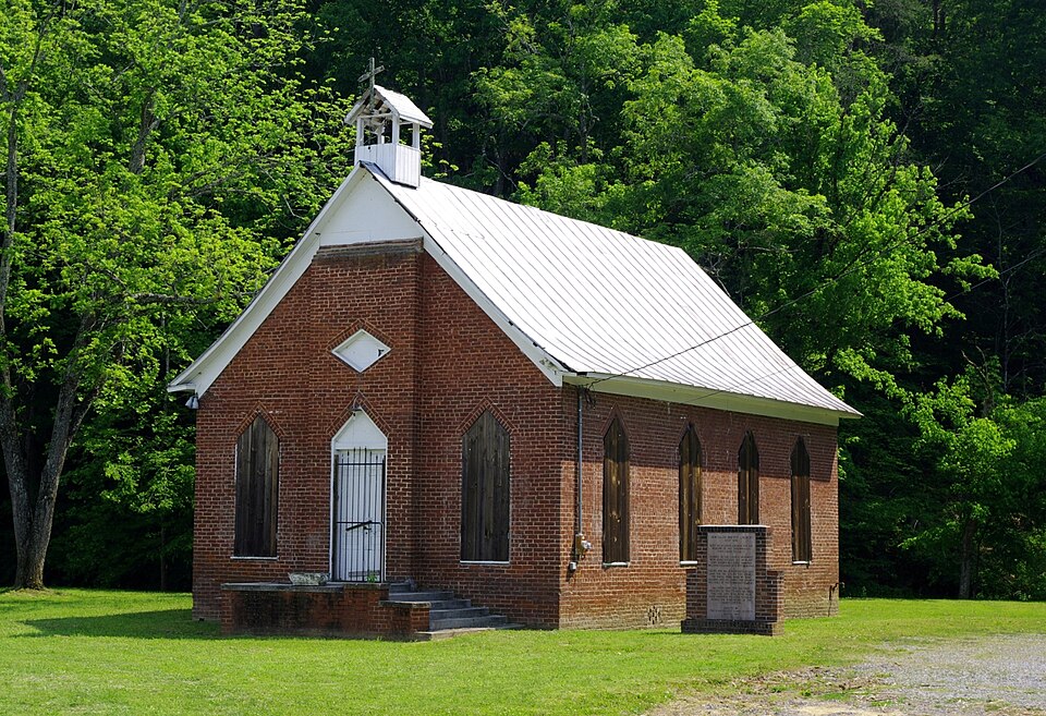
Built in 1886 (Gothic Revival). Listed on the National Register of Historic Places in 2003.
One of 38 National Register listings published here for Sevier County · listed in 2003 · category: Building · built in 1886, Gothic Revival.
Sources: the National Register database, National Park Service
Regional context, not property-specific evidence. The federal wildfire occurrence database lists 49 fires within 5 miles of New Salem Baptist Church between 1997 and 2017, burning about 278 acres in total. 2 started naturally. 12 were recorded as arson. Distance is straight-line from the map coordinates, so a fire counted here may appear on a neighbouring settlement's page as well.
| Reported cause | Fires |
|---|---|
| Debris and open burning | 21 |
| Arson/incendiarism | 12 |
| Missing data/not specified/undetermined | 7 |
| Fireworks | 3 |
| Railroad operations and maintenance | 2 |
| Natural | 2 |
| Power generation/transmission/distribution | 1 |
| Misuse of fire by a minor | 1 |
The most recent of them, most recent first, with the day each was reported and the service that recorded it.
| Date | Cause | Size | Reported by | Name on the report |
|---|---|---|---|---|
| 8 September 2005 | Debris and open burning | 1.0 acres | Tennessee Division of Forestry | not named |
| 30 September 2007 | Arson/incendiarism | under an acre | Tennessee Division of Forestry | CODY RD |
| 28 September 2007 | Arson/incendiarism | 2.0 acres | Tennessee Division of Forestry | RIVER BEND |
| 26 August 1997 | Arson/incendiarism | 1.0 acres | Tennessee Division of Forestry | not named |
| 19 August 2008 | Missing data/not specified/undetermined | 1.0 acres | Tennessee Division of Forestry | not named |
| 5 July 2014 | Fireworks | 6.0 acres | Tennessee Division of Forestry | TVA |
| 21 July 2007 | Natural | 3.0 acres | Tennessee Division of Forestry | PITTMAN |
| 8 June 1999 | Railroad operations and maintenance | under an acre | Tennessee Division of Forestry | not named |
Regional context, not property-specific evidence. The federal mineral resources record lists 8 workings within 5 miles of New Salem Baptist Church: 4 producers, 4 past producers. 4 still produce. What was taken out: Limestone, General, Stone, Crushed/Broken, Limestone, Dimension, Stone, Crushed/Broken, Clay. Distance is straight-line from the map coordinates, so a quarry counted here may appear on a neighbouring settlement's page as well.
| Where | Site | Commodity | Status | Recorded |
|---|---|---|---|---|
| Quarry | Limestone, Dimension | Past Producer | ||
| Quarry | Clay | Past Producer | ||
| Quarry | Limestone, Dimension | Past Producer | ||
| Quarry | Clay | Past Producer | ||
| Sevier County Highway Department Quarry | Limestone, General, Stone, Crushed/Broken | Producer | Limestone | |
| Sevier County Highway Dept. Quarry | Stone, Crushed/Broken | Producer | ||
| Sevierville Plant #508 | Limestone, General, Stone, Crushed/Broken | Producer | Limestone | |
| Sevierville Quarry & Plant #508 | Stone, Crushed/Broken | Producer |
Regional context, not property-specific evidence. The National Weather Service names Sevierville, the town this property stands in, in 72 storm reports between 1993 and 2025: 42 thunderstorm wind, 14 hail, 8 flood, 4 flash flood. No death or injury is recorded in these reports. Each account below is quoted exactly as the forecast office filed it, from the NOAA Storm Events Database, and each date opens the federal record of that event.
| When | Event | Place named | Harm | What the report says |
|---|---|---|---|---|
| July 1999 | Marine High Wind | Sevierville | $1,000,000 | no account filed |
| June 2013 | Tornado (EF1) | Sevierville | $50,000 | The NWS storm survey team concluded that an EF1 tornado tracked across eastern Sevier county of the 13th of June. It formed 14.1 miles east-southeast of Sevierville and lifted 14.2 miles east-southeast of Sevierville. It had a path length 0.5 miles and a path width of 150 yards. The max wind 90 mph caused widespread tree damage along its path. It also partly removed a roof from a single family home and awning of a porch before lifting. |
| June 2009 | Thunderstorm Wind | Sevierville | $30,000 | The newspaper reported several trees and powerlines downed by thunderstorm winds countywide. In addition, a hotel roof in Pigeon Force was damaged by the winds along with the 2 cars below the hotel. |
| July 2004 | Thunderstorm Wind | Sevierville | $30,000 | no account filed |
| June 2011 | Flash Flood | Sevierville | $20,000 | Law enforcement personnel reported heavy rain from thunderstorms caused many roads across the county to be flooded. |
| June 2007 | Thunderstorm Wind | Sevierville | $20,000 | Several trees were downed by thunderstorm winds northwest of Sevierville. Numerous powerlines were also down countywide. |
| May 2006 | Thunderstorm Wind | Sevierville | $20,000 | no account filed |
| May 2004 | Thunderstorm Wind | Sevierville | $20,000 | no account filed |
| June 2005 | Thunderstorm Wind | Sevierville | $18,000 | Several trees and powerlines in the Wilhite Community area of Jones Cove. Reported by Sevier County Electric. |
| February 2011 | Thunderstorm Wind | Sevierville | $15,000 | Law enforcement personnel reported numerous trees downed by thunderstorm wind in Sevierville. |
| August 2009 | Thunderstorm Wind | Sevierville | $15,000 | The utility company personnel reported a few trees and powerlines downed by thunderstorm winds in Sevierville. |
| June 2005 | Thunderstorm Wind | Sevierville | $15,000 | Several trees down northwest of Sevierville. |
| July 2004 | Thunderstorm Wind | Sevierville | $15,000 | no account filed |
| May 2002 | Thunderstorm Wind | Sevierville | $15,000 | no account filed |
| May 2006 | Thunderstorm Wind | Sevierville | $12,000 | no account filed |
| May 2003 | Thunderstorm Wind | Sevierville | $12,000 | no account filed |
| June 2014 | Thunderstorm Wind | Sevierville | $10,000 | Law enforcement personnel reported many trees downed by thunderstorms wind countywide. |
| August 2011 | Thunderstorm Wind | Sevierville | $10,000 | Law enforcement personnel reported a telephone pole downed by thunderstorm wind across Wye Drive near Sevierville. Several trees were also downed by thunderstorm wind across Walt Price Road near Sevierville. |
| June 2004 | Thunderstorm Wind | Sevierville | $10,000 | Several trees down countywide |
| June 2014 | Thunderstorm Wind | Sevierville | $8,000 | Law enforcement personnel reported several trees downed by thunderstorm wind in and around Sevierville. |
| June 2011 | Thunderstorm Wind | Sevierville | $5,000 | Law enforcement personnel reported powerlines downed by thunderstorm wind on Boyds Creek Highway 6 miles northwest of Sevierville. |
| October 2010 | Thunderstorm Wind | Sevierville | $5,000 | Law enforcement personnel reported a few trees downed by thunderstorm wind near the county line. |
| June 2007 | Thunderstorm Wind | Sevierville | $5,000 | Two trees were downed by thunderstorm winds across the county. |
| June 1995 | Thunderstorm Wind | Sevierville | $5,000 | Several trees including a 50-foot oak tree were blown down. |
| April 2002 | Hail | Sevierville | $5,000 | no account filed |
| August 2011 | Thunderstorm Wind | Sevierville | $3,000 | A trained spotter reported a few trees downed by thunderstorm wind near Sevierville. |
| July 2005 | Thunderstorm Wind | Sevierville | $3,000 | no account filed |
| July 2005 | Thunderstorm Wind | Sevierville | $3,000 | no account filed |
| August 2009 | Thunderstorm Wind | Sevierville | $2,000 | Law enforcement personnel reported one tree downed by thunderstorm winds on Providence Road northeast of Sevierville. |
| June 2007 | Thunderstorm Wind | Sevierville | $2,000 | Thunderstorm winds downed a tree on Highway 411 east of Sevierville. |
| July 1995 | Thunderstorm Wind | Sevierville | $2,000 | A few trees were blown down. |
| January 2013 | Flood | Sevierville | $1,000 | Nine roads closed across the county due to water. |
| February 1993 | Thunderstorm Wind | Sevierville | $500 | Several trees and power lines were knocked down. |
| September 2025 | Flood | Sevierville | - | Burden Hill Road at Eastgate Road is closed due to flooding per Sevier County EMA. |
| January 2024 | Flood | Sevierville | - | A shallow water rescue of a person from a car occurred off of Snapp Road. |
| July 2023 | Thunderstorm Wind | Sevierville | - | Multiple reports of trees blown down by strong thunderstorm winds in Sevierville. |
| August 2023 | Thunderstorm Wind | Sevierville | - | A few trees across the area were blown down by powerful thunderstorm winds. |
| February 2022 | Flood | Sevierville | - | Several roadways were closed due to flooding. |
| May 2021 | Thunderstorm Wind | Sevierville | - | Several trees were blown down in the Sevierville area. |
| February 2020 | Flood | Sevierville | - | Several road closures across the county. |
| July 2020 | Thunderstorm Wind | Sevierville | - | Many trees and power lines were reported down across the county. |
| January 2013 | Flood | Sevierville | - | Three roads reported closed. |
| January 2013 | Heavy Rain | Sevierville | - | Water ponding on roadways in areas. |
| June 2013 | Funnel Cloud | Sevierville | - | Amateur radio personnel reported a funnel cloud was sighted near Sevierville. |
| July 2012 | Thunderstorm Wind | Sevierville | - | A few trees were reported down two miles south southeast of Sevierville. |
| April 2011 | Hail | Sevierville | - | The pubic reported thunderstorms produced quarter-size hail 6 miles north of Sevierville. |
| April 2011 | Hail | Sevierville | - | A trained spotter reported thunderstorms produced quarter-size hail 2 miles southeast of Sevierville. |
| December 2009 | Flood | Sevierville | - | Areal flooding occurred due to long duration heavy rainfall across the area with several roads with water covering the roads with as much as two feet of water. |
| June 2009 | Hail | Sevierville | - | An amateur radio operator reported thunderstorms produced penny-size hail in east Sevierville. |
| September 2009 | Flood | Sevierville | - | Areal flooding occurred along and near highway 35 in Sevierville, Tennessee. Several inches of water was over the road, with a few areas briefly impassable due to the flooding. |
| April 2006 | Hail | Sevierville | - | Penny-size hail in Sevierville. |
| April 2006 | Hail | Sevierville | - | Quarter-size hail at Sevierville and Pigeon Forge. |
| April 2006 | Hail | Sevierville | - | Half dollar-size hail in Sevierville. |
| April 2006 | Hail | Sevierville | - | Nickel-size hail in Sevierville. |
| June 1997 | Thunderstorm Wind | Sevierville | - | Trees down on Thomas Circle and in western portion of the county. |
| June 1997 | Flash Flood | Sevierville | - | Creeks out of their banks on Henrytown Road. Flash flooding had washed out part of Henrytown Road. |
| September 2025 | Hail | Sevierville | - | no account filed |
| May 2006 | Hail | Sevierville | - | no account filed |
| May 2006 | Hail | Sevierville | - | no account filed |
| August 2003 | Flash Flood | Sevierville | - | no account filed |
No historic map-sheet match is published for this property yet. That does not mean no map exists. This record needs a coordinate-quality review before it can be joined to a sheet boundary. Browse the county's mapped places while that work is pending.
Other National Register properties close enough to walk or drive between, ordered by distance from this one. Both positions come from the same geocoding pass that matched these properties to their map sheets.
| Photograph | Property | Distance | Listed |
|---|---|---|---|
| Thomas Addition Historic District | 0.6 miles | 1994 | |
 | Waters House | 0.7 miles | 1975 |
 | US Post Office- Sevierville | 0.8 miles | 1997 |
 | Dwight and Kate Wade House | 0.8 miles | 1997 |
| Sevierville Masonic Lodge | 0.9 miles | 1980 | |
 | Sevierville Commercial Historic District | 0.9 miles | 1986 |
| National Archives record | The nomination case file for reference 03000696 in Record Group 79. |
| Sevier County | All 38 listed properties in this county. |