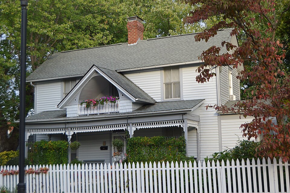
Built in 1894 (Victorian architecture). Listed on the National Register of Historic Places in 2007.
From the record
“Main Ave. in Erwin, Tennessee, was listed on the National Register of Historic Places in 2007. The listing included three contributing buildings and a contributing site.”
Wikipedia article A.R. Brown House, CC BY-SA 4.0.
One of 4 National Register listings published here for Unicoi County · listed in 2007 · category: Building · built in 1894, Victorian architecture.
National Register reference number. 07001167 - assigned by the National Park Service when the property was listed.
Fires near this property
66 since 1992
Regional context, not property-specific
evidence. The
federal wildfire occurrence database
lists 66 fires within 5 miles of A.R. Brown House
between 1992 and 2020, burning about 1,710 acres in total. 7 started naturally. 28 were recorded as arson.
Distance is straight-line from the map coordinates, so a fire counted
here may appear on a neighbouring settlement's page as well.
Reported cause
Fires
Arson/incendiarism
28
Debris and open burning
14
Natural
7
Missing data/not specified/undetermined
7
Equipment and vehicle use
4
Misuse of fire by a minor
3
Recreation and ceremony
2
Railroad operations and maintenance
1
The most recent of
them, most recent first, with the day each was reported and the service
that recorded it.
Regional context, not property-specific
evidence. The federal mineral resources record lists
79 workings within 5 miles of A.R. Brown House: 71 past producers, 5 producers, 2 prospects, 1 occurrence.
5 still produce. What was taken out: Iron, Zinc, Manganese, Sand and Gravel, Construction. Distance is straight-line from the
map coordinates, so a quarry counted here may appear on a neighbouring
settlement's page as well.
Regional context, not property-specific
evidence. The National Weather Service names
Erwin, the town this property stands in, in 37 storm reports between 1994 and 2024: 25 thunderstorm wind, 6 hail, 5 flash flood, 1 flood.
The reports record 9 deaths. Each account below is quoted exactly as the forecast office
filed it, from the NOAA Storm Events Database, and each date
opens the federal record of that event.
Flooding along portions of Hwy 19 was reported at 8:00 am EST. Reports from spotters, social media, broadcast media, and county officials increased through the day, including flooded roadways at 8:51 am EST. Flooding of the Nolichucky River at the Jackson Love Hwy bridge area was noted at 9:32 am EST. Flooding of the grounds around Unicoi Hospital was happening around 10:00 am EST, when a berm was overtopped or breached. The hospital structure was taking water by 11:00 am EST, and evacuation by ground had become unsafe. Occupants were taken to the roof, but winds prevented air rescue while rapidly rising and turbulent river flooding prevented water rescue. The hospital was surrounded and inundated by waters at least 7 feet deep by 12:45 pm EST. Flood waters inundated numerous nearby properties and structures including a church, wrecked nearby portions of I-26, and caused significant damage to factories along the river downstream. Hospital occupants were at last rescued by helicopter in the afternoon. Nine known fatalities found in the county; the final three in the list were North Carolina residents, and it is unknown if they were in Unicoi county when they perished or if they were swept in from North Carolina. Most of the deaths were workers swept from a factory parking lot. Flooding impacts continued across the county through the night.
Widespread flash flooding over the northern portion of the county from Erwin northward. Numerous road closures. Water intrusion into a dozen homes and several businesses. Roads undercut. Two evacuations.
Nearby gauge reported 2.38 inches of rain in 30 to 45 minutes. High water was observed near Erwin Town Hall, where sandbagging occurred outside, while 6 to 8 inches of water came up into the basement from the sewer lines. Flooding also occurred in the Old Farm subdivision, in areas along 7th Street, on Rex Lewis Road, and on Zane Whitson Drive. City officials said water rushed through town as fast as it could. Water got inside two police cruisers. A few downtown businesses received flood damage.
No historic map-sheet match is published
for this property yet. That does not mean no map exists. This record needs
a coordinate-quality review before it can be joined to a sheet boundary.
Browse the county's mapped places while that work is
pending.
Listed places nearby
2 within 8 miles
Other National Register properties close
enough to walk or drive between, ordered by distance from this one. Both
positions come from the same geocoding pass that matched these properties
to their map sheets.
Listing record. National Park Service National Register of Historic Places, listed-properties dataset, current to 2026-05-22.
Map join. Address geocoded through the United States Census geocoder, then tested against the published boundary of every sheet in the USGS Historical Topographic Map Collection.
How this page is made. Listing fields come from federal records; map-sheet coverage is a labelled coordinate-to-boundary calculation, not a source-field claim.
Wildfire. Short, Karen C. 2022. Spatial wildfire occurrence data for the United States, 1992-2020 [FPA_FOD_20221014]. 6th Edition. Fort Collins, CO: Forest Service Research Data Archive. https://doi.org/10.2737/RDS-2013-0009.6 Collected with United States Government funding and usable without additional permissions or fees.
Mines and quarries. USGS Mineral Resources Data System (MRDS) https://mrdata.usgs.gov/mrds/ A work of the United States government, no copyright under 17 U.S.C. 105.
Storms. NOAA National Centers for Environmental Information, Storm Events Database https://www.ncei.noaa.gov/stormevents/ A work of the United States government, no copyright under 17 U.S.C. 105. Narratives are quoted verbatim from the National Weather Service report and are not edited or summarised.
 Block