 Block
BlockFrom the record
1 National Register listing published here.
Sources: the National Register database, National Park Service
82 topographic sheets cover 28 settlements here, and 1 property is on the National Register of Historic Places.
1 National Register listing published here.
Sources: the National Register database, National Park Service
Every property in this county listed on the National Register of Historic Places, with the year it was listed and the federal nomination document.
| Photograph | Property | Type | Listed | Reference |
|---|---|---|---|---|
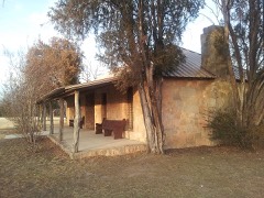 | Camp Colorado Replica | building | 2018 | 100002345 |
Drawn when these were printed as single large sheets: the town seen from the air, and the county divided into its farms with every owner named. Each opens the original at the Library of Congress.


The thermometers that kept this county's weather, and the gages that measured the flow of its streams, as the federal records hold them. The extremes below are measured values from those records, not estimates.
Who lived here in 1950, one enumeration district at a time, as the Census Bureau described each district. Each row opens its official National Archives result, with Population Schedules and ED Maps available there.
Every wildfire the federal occurrence database records inside this county: 600 of them, burning about 41,796 acres. 46 started naturally and 9 were recorded as arson. Each settlement page carries the fires within five miles of it.
| Reported cause | Fires |
|---|---|
| Missing data/not specified/undetermined | 212 |
| Equipment and vehicle use | 127 |
| Debris and open burning | 101 |
| Natural | 46 |
| Railroad operations and maintenance | 40 |
| Power generation/transmission/distribution | 35 |
| Smoking | 16 |
| Recreation and ceremony | 9 |
| Arson/incendiarism | 9 |
| Misuse of fire by a minor | 5 |
The five largest, by the area the report gives. None of them was recorded as arson.
| Date | Cause | Size | Reported by | Name on the report |
|---|---|---|---|---|
| 12 August 2010 | Missing data/not specified/undetermined | 2,000 acres | Texas A & M Forest Service | COW CREEK FIRE |
| 5 June 2008 | Missing data/not specified/undetermined | 1,500 acres | Texas A & M Forest Service | BREWER |
| 27 December 2005 | Missing data/not specified/undetermined | 1,500 acres | Texas A & M Forest Service | not named |
| 1 January 2006 | Missing data/not specified/undetermined | 1,408 acres | Texas A & M Forest Service | SANTA ANNA |
| 12 September 2016 | Equipment and vehicle use | 1,031 acres | Texas A & M Forest Service | PRIDY |
| 30 January 2008 | Missing data/not specified/undetermined | 1,000 acres | Texas A & M Forest Service | not named |
| 27 December 2005 | Equipment and vehicle use | 1,000 acres | Texas A & M Forest Service | not named |
| 18 February 2009 | Missing data/not specified/undetermined | 1,000 acres | Texas A & M Forest Service | MILLER FIRE |
Every settlement page carries the fires within five miles of it - see the settlement index below.
The NOAA Storm Events Database holds 506 reports for this county, causing 3 deaths, 17 injuries and about $18,429,900 in recorded property damage. Each settlement page carries the reports that name it.
| Kind of event | Reports |
|---|---|
| Hail | 293 |
| Thunderstorm Wind | 131 |
| Tornado | 42 |
| Flash Flood | 34 |
| Funnel Cloud | 3 |
| Flood | 2 |
| Heavy Rain | 1 |
The most serious of them, by death, then injury, then recorded damage. The accounts are quoted exactly as the forecast office filed them.
| When | Event | Place named | Harm | What the report says |
|---|---|---|---|---|
| May 1975 | Tornado (F3) | not stated | 2 killed, 5 hurt | no account filed |
| May 2000 | Thunderstorm Wind | Voss | 1 killed, 4 hurt, $50,000 | Severe thunderstorm winds struck O.H. Ivie Reservoir, capsizing 10 to 15 boats on the lake. Tragically, one person was killed and 4 others injured when the boat they were in was pushed into a bluff and capsized. |
| March 1982 | Tornado (F3) | not stated | 5 hurt, $2,500,000 | no account filed |
| April 1979 | Tornado (F3) | not stated | 1 hurt, $2,500,000 | no account filed |
| March 1992 | Tornado (F2) | not stated | 1 hurt, $250,000 | no account filed |
| May 1994 | Thunderstorm Wind | Trickham | 1 hurt, $50,000 | Several mobile homes were damaged by thunderstorm winds. A child suffered an eye injury from glass debris. |
| May 2006 | Hail | Coleman | $5,000,000 | Hailstones from golfball to tennis ball size damaged windshields, skylights, and roofs to almost every residence, out building, exposed vehicle, and carport located in Coleman. The large hail also littered lawns with leaves and branches and even killed birds. The large hail also left big dents in the ground. |
| March 2001 | Hail | Coleman | $2,800,000 | Hail up to the size of golf balls fell across a large part of the city of Coleman, causing extensive damage to area roofs and vehicles. Local insurance agencies reported nearly 1000 insurance claims, with damage reaching almost 3 million dollars. |
| July 2002 | Flash Flood | Countywide | $800,000 | Rains of 10 to 12 inches fell over Coleman County in the early morning hours of the 6th. This is in addition to the 8 to 10 inches that had fallen over the area in the days leading up to this flood. The area along Jim Ned Creek and Lake Coleman were hit especially hard. As the Coleman County police department was performing a water rescue on Jim Need Creek near Burkett, they were quoted saying, "a wall of water is flowing down Jim Need Creek." Several roads and fences were damaged in the county, crops ruined and livestock missing. In the Lake Coleman area, there were four homes with major damage and 2 homes with minor damage. |
| June 2019 | Hail | Santa Anna | $500,000 | A trained spotter reported golf ball to slightly larger hail falling in Santa Anna, off of Main Street. |
| May 1994 | Thunderstorm Wind | Talpa | $500,000 | A livestock auction barn was heavily damaged, horse trailers were blown over, and many horses were trapped in the debris. Dozens of horses were killed or had to be destroyed due to their injuries. |
| May 1994 | Thunderstorm Wind | not stated | $500,000 | The severe thunderstorms which moved across Coleman County during the evening hours damaged virtually every barn and storage building in the southern part of the county, as well as blowing down thousands of trees, and hundreds of power line poles. |
| May 1996 | Thunderstorm Wind | Coleman | $500,000 | no account filed |
| December 2004 | Tornado (F0) | Santa Anna | $250,000 | no account filed |
| May 1996 | Thunderstorm Wind | Shields | $250,000 | no account filed |
| March 1992 | Tornado (F1) | not stated | $250,000 | no account filed |
| June 1982 | Tornado (F2) | not stated | $250,000 | no account filed |
| May 1995 | Tornado (F1) | Coleman | $120,000 | A tornado touched down in Coleman destroying one house and damaging several others. |
| May 2007 | Tornado (EF1) | Rockwood | $100,000 | A tornado started about three miles to the west of Rockwood and moved across the south side of Rockwood where it damaged a few buildings including the new Post Office. The tornado then continued to the east of Rockwood for an additional three to four miles damaging barns and trees. Shortly after the tornado passed, winds of 65 to 75 mph ripped through the area causing additional damage. |
| May 2002 | Hail | Coleman | $100,000 | A severe thunderstorm dropped hail up to golfball size on Coleman for several minutes. There were reports of broken windows and roof damage. |
| June 1997 | Flash Flood | Coleman | $100,000 | Rainfall rates were up to three inches per hour overnight the 22nd and 23rd. Rain totals throughout the county were all around five inches. The city streets in Coleman were closed due to the floodwaters. |
| June 1997 | Flash Flood | Coleman | $100,000 | Between two and a half and five inches of rain fell over a large part of Coleman County the morning of the 6th. Almost five inches of rain was reported in Coleman and about six inches of rain in Santa Anna. Cars stalled in the floodwaters in the streets of Coleman. |
| June 1997 | Hail | Coleman | $100,000 | no account filed |
| April 2004 | Hail | Glen Cove | $80,000 | Very large hail caused damage to vehicles and dwellings near Hoards Creek Lake. |
| September 1996 | Flash Flood | Coleman | $75,000 | no account filed |
| July 2009 | Thunderstorm Wind | Coleman | $70,000 | Severe thunderstorm wind gusts blew down numerous tree limbs in Coleman. Also, several buildings received damage across Coleman County. |
| May 1995 | Tornado (F0) | Burkett | $60,000 | A tornado touched down on Farm-to-Market Road 586 near Burkett, destroying a barn, downing power lines, and damaging three homes. |
| May 1994 | Tornado (F1) | Burkett | $50,000 | A tornado at Burkett blew down a 240-kilovolt power line pole. |
| May 1996 | Thunderstorm Wind | Coleman | $50,000 | no account filed |
| November 1996 | Thunderstorm Wind | Santa Anna | $50,000 | no account filed |
| August 1997 | Hail | Coleman | $25,000 | no account filed |
| November 1996 | Thunderstorm Wind | Valera | $25,000 | no account filed |
| November 1996 | Hail | Santa Anna | $25,000 | no account filed |
| April 1988 | Tornado (F1) | not stated | $25,000 | no account filed |
| October 1984 | Tornado (F0) | not stated | $25,000 | no account filed |
| May 1971 | Tornado (F2) | not stated | $25,000 | no account filed |
| April 1970 | Tornado (F2) | not stated | $25,000 | no account filed |
| April 1964 | Tornado (F1) | not stated | $25,000 | no account filed |
| March 2004 | Thunderstorm Wind | Coleman | $15,000 | Several large trees were knocked down and roof damage was reported in town. |
| June 2002 | Thunderstorm Wind | Coleman | $12,000 | Trees and power lines were downed over the city of Coleman due to strong thunderstorm winds. |
| April 2008 | Thunderstorm Wind | Coleman | $10,000 | There were several roofs damaged with one roof blown off. |
| May 2007 | Thunderstorm Wind | Rockwood | $10,000 | Damaging winds with a squall line moved through the community of Rockwood in the wake of a tornado that passed through the community just prior to the strong winds and heavy rains. |
| May 2006 | Thunderstorm Wind | Talpa | $10,000 | The strongs winds blew a roof off of a home |
| January 2004 | Tornado (F0) | Novice | $10,000 | A tornado developed from a low topped storm south of the community of Novice and moved northwest across the community. Portions of two roofs were blown off of homes and numerous windows were broken. |
| November 2004 | Thunderstorm Wind | Coleman | $10,000 | Several power poles were blown down in the city of Coleman. |
| July 1998 | Thunderstorm Wind | Coleman | $10,000 | High winds damaged the football stadium in Coleman, knocked power lines down, and tore a roof off of a mobile home. |
| June 1998 | Thunderstorm Wind | Gouldbusk | $10,000 | Wind gust of 64 mph damaged sailboats at the O.H. Ivie Reservoir |
| June 1998 | Thunderstorm Wind | Coleman | $10,000 | A restaurant had a third of its roof peeled back, allowing extensive water damage below. |
| August 1997 | Thunderstorm Wind | Coleman | $10,000 | Large tree branches blown down. |
| May 2007 | Thunderstorm Wind | Valera | $8,000 | These winds were embedded in the large squall line that moved through the Heartland, and the winds produced a large swath of damage across the region. Minor roof damage and broken tree limbs were reported in the small town of Valera. |
| June 2007 | Flash Flood | Coleman | $8,000 | Several farm to market roads across Coleman County were closed because of high water. FM2805 from the junction of U.S. 67 to State Highway 153 was closed. FM2131 from Shields to Coleman was closed. Also FM0503 from the intersection of State Highway 206 to the McCulloch County line was closed. |
| July 2002 | Flash Flood | East Portion | $8,000 | Law enforcement reported several roads under water over the North and East portions of the county. |
| February 2004 | Thunderstorm Wind | Leaday | $8,000 | no account filed |
| November 2004 | Thunderstorm Wind | Santa Anna | $7,000 | Power lines were blown down in the Santa Ana area. |
| June 1998 | Thunderstorm Wind | Coleman | $6,000 | Several sailboats run aground at O.H. Ivie Reservoir |
| March 2007 | Hail | Novice | $5,000 | Golfball size hail and strong winds were reported in Novice. |
| May 2007 | Thunderstorm Wind | Whon | $5,000 | This is a continuation of the strong downburst winds associated with an intense squall line that produced additional damage in the wake of a tornado that moved through the area just prior to the onset of the strong winds. |
| March 2005 | Thunderstorm Wind | Talpa | $5,000 | Barn destroyed. |
| May 1994 | Thunderstorm Wind | Hords Creek Lake | $5,000 | Thunderstorm winds damaged trees and camper trailers. |
| May 1994 | Thunderstorm Wind | Trickham | $5,000 | A business was unroofed by thunderstorm winds. |
The Survey's mineral resources record lists 7 workings inside this county. 4 still produce and 3 are closed or unrecorded. Each settlement page carries the workings within five miles of it.
| Commodity | Workings |
|---|---|
| Clay | 4 |
| Copper | 1 |
| Fire Clay (Refractory) | 1 |
| Silica | 1 |
The least common of them first, because a county's hundredth gravel pit says nothing its first ten did not.
| Where | Site | Commodity | Status | Recorded |
|---|---|---|---|---|
| Baker-1 | Copper | Occurrence | ||
| Unknown | Silica | Past Producer | ||
| Unnamed Pit | Fire Clay (Refractory) | Producer | Sedimentary | |
| Coleman Plant | Clay | Producer | ||
| Martin Brick Co Pit | Clay | Producer | ||
| Martin Brick Co Plant and Abnd Pit | Clay | Producer | ||
| Unnamed Pit | Clay | Past Producer | Sedimentary |
Named settlements recorded in the Geographic Names Information System, each with the topographic sheets covering it. Villages, hamlets and abandoned places alike. Each is shown with the nearest named watercourse or landform and the survey quadrangle it falls on.
Coleman census division · 76828 · On Deadman Branch · Burkett quadrangle
15 sheets, 1887 to 1985
Santa Anna census division · 76873 · On Bull Creek · Fife quadrangle
14 sheets, 1894 to 1985
Coleman census division · 76834 · On Indian Creek · Coleman NE quadrangle
14 sheets, 1887 to 1985
Talpa census division · 76834 · On North Prong Hords Creek · Talpa quadrangle
12 sheets, 1892 to 1985
Coleman census division · 76834 · On Bachelor Prong · Coleman quadrangle
13 sheets, 1887 to 1985
Talpa census division · 76852 · Near Rough Hollow · Fife quadrangle
14 sheets, 1894 to 1985
Talpa census division · 76888 · On Grape Creek · O.H. Ivie Reservoir quadrangle
15 sheets, 1892 to 1985
No longer a settlement
Talpa census division · 76845 · On Little Panther Creek · Gouldbusk quadrangle
12 sheets, 1887 to 1985
Coleman census division · 76878 · Lake San Tana quadrangle
13 sheets, 1887 to 1985
Santa Anna census division · 76878 · On Santa Anna Mountains · Santa Anna quadrangle
13 sheets, 1887 to 1985
Talpa census division · 76884 · On Bead Mountain Creek · Valera quadrangle
11 sheets, 1892 to 1985
Coleman census division · 76828 · On Wilkerson Branch · Webbville quadrangle
9 sheets, 1931 to 1985
The vanished settlements of Coleman County: the places named above that are no longer on the map.