 Block
BlockFrom the record
One of 2 National Register listings published here for Trinity County · listed in 2005 · category: Building.
Sources: the case file at the National Archives · the National Register database, National Park Service
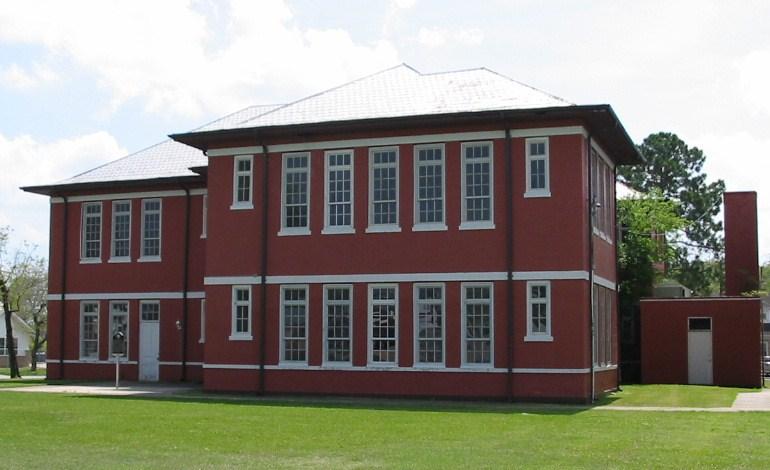
Listed on the National Register of Historic Places in 2005.
One of 2 National Register listings published here for Trinity County · listed in 2005 · category: Building.
Sources: the case file at the National Archives · the National Register database, National Park Service
Regional context, not property-specific evidence. The federal wildfire occurrence database lists 35 fires within 5 miles of Red Schoolhouse, Old between 1992 and 2018, burning about 1,213 acres in total. 4 started naturally. 1 was recorded as arson. Distance is straight-line from the map coordinates, so a fire counted here may appear on a neighbouring settlement's page as well.
| Reported cause | Fires |
|---|---|
| Debris and open burning | 14 |
| Missing data/not specified/undetermined | 8 |
| Natural | 4 |
| Equipment and vehicle use | 3 |
| Misuse of fire by a minor | 2 |
| Arson/incendiarism | 1 |
| Smoking | 1 |
| Railroad operations and maintenance | 1 |
| Power generation/transmission/distribution | 1 |
The most recent of them, most recent first, with the day each was reported and the service that recorded it.
| Date | Cause | Size | Reported by | Name on the report |
|---|---|---|---|---|
| 5 September 1993 | Debris and open burning | 2.0 acres | Texas A & M Forest Service | not named |
| 26 September 2005 | Missing data/not specified/undetermined | 10 acres | Texas A & M Forest Service | CONROE - 122 |
| 23 September 2005 | Missing data/not specified/undetermined | 5.0 acres | Texas A & M Forest Service | CONROE - 121 |
| 9 August 2010 | Natural | 432 acres | Livingston Area | LIVINGSTON - 257 |
| 9 August 1996 | Natural | 5.0 acres | Texas A & M Forest Service | not named |
| 5 August 1996 | Debris and open burning | 82 acres | Texas A & M Forest Service | not named |
| 26 August 2000 | Smoking | 5.0 acres | Texas A & M Forest Service | CONROE - 327 |
| 25 August 2017 | Missing data/not specified/undetermined | 46 acres | Texas A & M Forest Service | 4539 |
Regional context, not property-specific evidence. The federal mineral resources record lists 1 working within 5 miles of Red Schoolhouse, Old: 1 past producer. None of them still produces. What was taken out: Clay. Distance is straight-line from the map coordinates, so a quarry counted here may appear on a neighbouring settlement's page as well.
| Where | Site | Commodity | Status | Recorded |
|---|---|---|---|---|
| Olson Chemical Co | Clay | Past Producer |
Regional context, not property-specific evidence. The National Weather Service names Trinity, the town this property stands in, in 55 storm reports between 1995 and 2024: 26 thunderstorm wind, 12 flash flood, 12 hail, 3 tornado. The reports record 4 injuries. Each account below is quoted exactly as the forecast office filed it, from the NOAA Storm Events Database, and each date opens the federal record of that event.
| When | Event | Place named | Harm | What the report says |
|---|---|---|---|---|
| November 1996 | Tornado (F0) | Trinity | 2 hurt, $25,000 | no account filed |
| May 2013 | Thunderstorm Wind | Trinity | 1 hurt, $40,000 | A roof was blown off a residential home. There were numerous trees and power lines downed in town, as well. There was one injury caused by a downed power line. |
| May 2007 | Thunderstorm Wind | Trinity | 1 hurt, $8,000 | Trees blown down upon a home along FM 356. One person pinned underneath a fallen tree. |
| January 1999 | Tornado (F2) | Trinity | $750,000 | Funnel reported over the Trinity River bridge. Storm abruptly took a right turn along the eastern shore of Lake Livingston. Tornado touched down 7 miles south of Trinity. Effected Timber Bay, Whiterock Estates, Azteck Cove and Timber Cove subdivisions. Major damage caused by trees falling on residences/vehicles. Strongest damage (and not necessarly caused by falling trees) occurred at Whiterock Estates. Resident in Timber Bay (where the first touchdown occurred) had anemometer that clocked 110 mph winds before it was blown away. Mostly F1 damage with F2 damage in Whiterock Estates. |
| February 2011 | Thunderstorm Wind | Trinity | $30,000 | Several trees were reported downed on Highway 356, Highway 19, and Highway 287. Roofs were reported blown off of houses in Trinity. |
| March 1995 | Thunderstorm Wind | Trinity | $30,000 | Downburst wind destroyed two businesses and damaged several others in Trinity. Numerous trees also downed. |
| April 2004 | Hail | Trinity | $25,000 | Golfball-size hail in the town of Trinity. |
| July 1997 | Flash Flood | Trinity | $25,000 | HWY 19 flooded in the Trinty area. Water several feet deep over FM 3188 for over 1/4 mile near Skains Community Cemetary Rd and road appeared to sustain damage. Water over HWY 94 east of Glendale. |
| March 1995 | Thunderstorm Wind | Trinity | $25,000 | High winds damaged several homes, businesses, and a school. Trees and power lines were also blown down. |
| June 2004 | Thunderstorm Wind | Trinity | $15,000 | Widespread power outages in Trinity. |
| February 1998 | Thunderstorm Wind | Trinity | $15,000 | 75 mph winds in Trinity, trees down across the county. |
| March 2017 | Thunderstorm Wind | Trinity | $10,000 | Oak trees were snapped and uprooted, power lines were snapped and tree limbs fell onto homes along Winding Creek Road. |
| June 2004 | Flash Flood | Trinity | $10,000 | Flooding on FM 356. |
| November 2004 | Thunderstorm Wind | Trinity | $10,000 | Power line and tree down at intersection of J.B. Price and Evans Roads with part of a barn destroyed. |
| October 2001 | Tornado (F1) | Trinity | $10,000 | Media reported a tornado damaged one home. |
| March 2000 | Thunderstorm Wind | Trinity | $10,000 | Trees down. |
| April 2000 | Hail | Trinity | $10,000 | no account filed |
| April 2020 | Hail | Trinity | $9,000 | Golf ball to lime and hen egg sized hail was reported. |
| August 2003 | Thunderstorm Wind | Trinity | $9,000 | Trees (including a 30 foot tall and 1 foot diameter ash tree) down. |
| March 1999 | Hail | Trinity | $7,000 | no account filed |
| May 2024 | Thunderstorm Wind | Trinity | $5,000 | A large tree was downed and damaged power lines along East Pagoda Road. |
| June 1997 | Thunderstorm Wind | Trinity | $5,000 | Trees blown down on northern side of Lake Livingston |
| June 1997 | Thunderstorm Wind | Trinity | $5,000 | Trees blown down |
| July 1997 | Thunderstorm Wind | Trinity | $5,000 | 16 pines down along a 1/4 mile stretch of HWY 19 from Trinity to FM 1817. |
| January 1997 | Thunderstorm Wind | Trinity | $5,000 | Trees blown down blocking HWY 94. |
| April 1997 | Thunderstorm Wind | Trinity | $5,000 | no account filed |
| February 2009 | Thunderstorm Wind | Trinity | $4,000 | Thunderstorm winds downed power lines just outside of Trinity. |
| January 2012 | Thunderstorm Wind | Trinity | $3,000 | Severe thunderstorm winds downed a cluster of trees around the Trinity area. |
| May 2009 | Thunderstorm Wind | Trinity | $3,000 | Trees were reported down within the town and also along FM 356. |
| August 2009 | Hail | Trinity | $3,000 | A severe thunderstorm produced golf ball size hail near the intersection of SR 94 and FM 356. |
| May 2008 | Thunderstorm Wind | Trinity | $3,000 | There were powerlines and trees reported down in the town of Trinity. |
| October 1998 | Flash Flood | Trinity | $3,000 | High water on HWY 19. |
| January 1998 | Flash Flood | Trinity | $3,000 | Street flooding in Trinity. |
| April 1998 | Hail | Trinity | $3,000 | Hail on FM 356. |
| August 1998 | Thunderstorm Wind | Trinity | $3,000 | no account filed |
| April 1998 | Hail | Trinity | $3,000 | no account filed |
| March 1998 | Hail | Trinity | $3,000 | no account filed |
| May 2020 | Hail | Trinity | $2,000 | Golf ball size hail was reported. |
| May 2006 | Hail | Trinity | $2,000 | Penny size hail between Trinity and Groveton. |
| June 2001 | Thunderstorm Wind | Trinity | $1,000 | Large oak tree down on Highway 94. |
| June 1998 | Thunderstorm Wind | Trinity | $500 | Boat overturned in Lake Livingston by high wind gusts. |
| May 2024 | Flash Flood | Trinity | - | FM 230 west of Trinity was impassable due to flash flooding. |
| May 2024 | Flash Flood | Trinity | - | FM 356 east of Trinity was impassable due to flash flooding. |
| April 2024 | Flash Flood | Trinity | - | Flash flooding prompted a swift water rescue along FM 356. |
| May 2024 | Hail | Trinity | - | Quarter sized hail and power outages were reported. |
| April 2020 | Hail | Trinity | - | Quarter sized hail was reported. |
| April 2019 | Thunderstorm Wind | Trinity | - | There were numerous trees and power lines downed with a tree landing on a home. |
| May 2019 | Thunderstorm Wind | Trinity | - | A downed tree knocked down some power lines. |
| May 2015 | Flash Flood | Trinity | - | Parts of FM 230 were flooded and closed. |
| May 2015 | Flash Flood | Trinity | - | Many county roads were closed due to flooding, especially from the Friday area to the Davy Crockett National Forest area. |
| June 2015 | Flash Flood | Trinity | - | There was county wide street flooding. |
| January 2007 | Flash Flood | Trinity | - | Flooding along FM 356 in and around Trinity. |
| November 2004 | Flash Flood | Trinity | - | FM 2262 at Alabama Creek in Trinity closed due to flooding. |
| May 2000 | Funnel Cloud | Trinity | - | Funnel cloud half mile north of FM 356 near Galloway Marina. |
| November 2004 | Funnel Cloud | Trinity | - | no account filed |
No historic map-sheet match is published for this property yet. That does not mean no map exists. This record needs a coordinate-quality review before it can be joined to a sheet boundary. Browse the county's mapped places while that work is pending.
| National Archives record | The nomination case file for reference 05000865 in Record Group 79. |
| Trinity County | All 2 listed properties in this county. |