BlockBefore
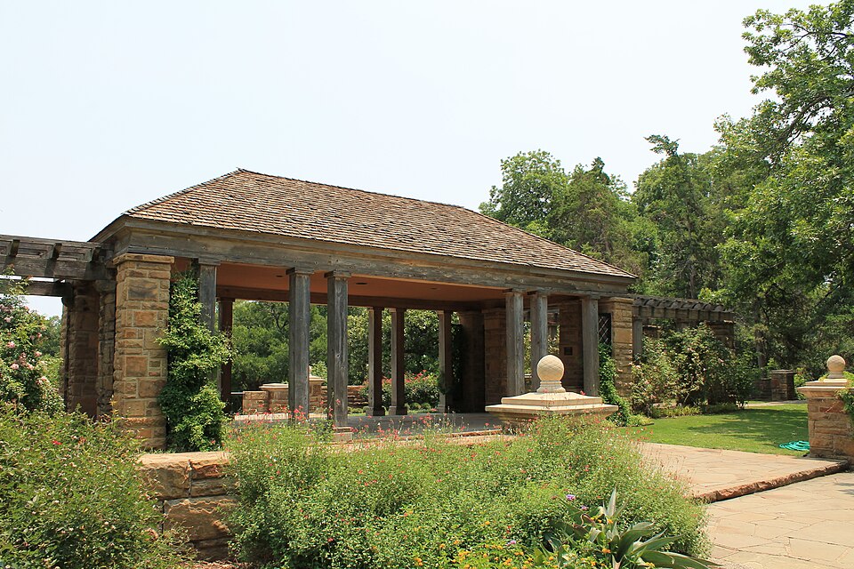
Photograph of Fort Worth Botanic Garden
Photograph by Renelibrary, CC BY-SA 3.0. Via Wikimedia Commons.

Fort Worth Botanic Garden

Built in 1933 (Renaissance Revival architecture). Listed on the National Register of Historic Places in 2009.

From the record

“The Fort Worth Botanic Garden is a botanical garden located in the cultural district of Fort Worth, Texas. Established in 1934, the garden is the oldest major botanic garden in Texas and was added to the National Register of Historic Places in 2009.”

Wikipedia article Fort Worth Botanic Garden, CC BY-SA 4.0.

One of 128 National Register listings published here for Tarrant County · listed in 2009 · category: District · built in 1933, Renaissance Revival architecture, by Hare & Hare.

Sources: the Wikipedia article · the case file at the National Archives · the National Register database, National Park Service

The listing

  • What is counted as historic. The nomination lists 14 structuress, 5 sitess, 1 building as contributing to the listing.
  • Address. 3220 Botanic Garden Blvd., Fort Worth, 76107
  • When was it listed? January 2009
  • Category. district
  • Census division. Fort Worth
  • When was it built? 1933
  • Architectural style. Renaissance Revival architecture
  • Architect. Hare & Hare
  • National Register reference number. 08001400 - the number the National Park Service assigned this property when it was listed, and the key its nomination file is catalogued under at the National Archives.

Fires near this property

566 since 2009

Regional context, not property-specific evidence. The federal wildfire occurrence database lists 566 fires within 5 miles of Fort Worth Botanic Garden between 2009 and 2020, burning about 121 acres in total. 2 started naturally. 3 were recorded as arson. Distance is straight-line from the map coordinates, so a fire counted here may appear on a neighbouring settlement's page as well.

Reported cause Fires
Missing data/not specified/undetermined508
Power generation/transmission/distribution17
Railroad operations and maintenance9
Recreation and ceremony8
Equipment and vehicle use7
Misuse of fire by a minor4
Smoking4
Arson/incendiarism3
Debris and open burning3
Natural2
Other causes1

The most recent of them, most recent first, with the day each was reported and the service that recorded it.

DateCause SizeReported by Name on the report
9 September 2019Missing data/not specified/undeterminedunder an acreTexas A & M Forest ServiceOAKHURST SCENIC
8 September 2019Missing data/not specified/undeterminedunder an acreTexas A & M Forest ServiceFARNSWORTH
7 September 2015Missing data/not specified/undeterminedunder an acreTexas A & M Forest Service2500
6 September 2020Missing data/not specified/undeterminedunder an acreTexas A & M Forest ServiceSOUTH FREEWAY
6 September 2019Missing data/not specified/undeterminedunder an acreTexas A & M Forest ServiceAIRPORT FREEWAY
6 September 2015Missing data/not specified/undeterminedunder an acreTexas A & M Forest ServiceCOLD SPRINGS
6 September 2014Missing data/not specified/undeterminedunder an acreTexas A & M Forest ServiceNE 23RD
5 September 2020Missing data/not specified/undeterminedunder an acreTexas A & M Forest ServiceROSEDALE

Every fire recorded in Tarrant County

Storms near this property

37 since 1993

Regional context, not property-specific evidence. The National Weather Service names Fort Worth, the town this property stands in, in 37 storm reports between 1993 and 1995: 21 hail, 14 thunderstorm wind, 2 tornado. The reports record 109 injuries. Each account below is quoted exactly as the forecast office filed it, from the NOAA Storm Events Database, and each date opens the federal record of that event.

WhenEvent Place namedHarm What the report says
May 1995HailFort Worth109 hurtAt Trinity Park, just west of downtown Fort Worth, an outdoor festival, called Mayfest, was in progress. Over 10,000 people were caught in the open with little shelter by hail up to softball-size. One hundred nine people were treated for injuries at hospitals, four people were in critical condition. Many injuries occurred as parents covered their children with their bodies to protect them from the hail.
April 1995Tornado (F2)Fort Worth$4,000,000The tornado track was approximately five miles long from the Texas Christian University campus to 1.5 miles southeast of downtown Fort Worth. At least six vehicles were overturned, major damage was sustained by an apartment complex, and significant damage occurred to roofs. Power lines, telephone and power poles, and a large number of trees were blown down by high winds.
November 1994Tornado (F0)Fort Worth$500,000A brief tornado produced intermittent damage along a 1.2 mile path in southwest Fort Worth between 600 and 630 am. Large tree limbs were broken, numerous wood fences were blown down and a school had major damage to a composition roof. Total damage was $60-70,000.
November 1994Thunderstorm WindFort Worth$50,000A downburst 5.5 miles northeast of the track of the first storm between 600 and 630 am peeled off a large section of a house roof and carried it 100 yards. Minor damage occurred to surrounding homes. Total damage was $10-20,000.
April 1995Thunderstorm WindFort Worth$10,000Large tree limbs and signs were blown down in South Fort Worth.
August 1995Thunderstorm WindFort Worth$5,000High winds damaged the roof of a business in east Fort Worth.
June 1994Thunderstorm WindFort Worth$5,000Signs and power line poles were blown down by thunderstorm winds.
July 1994Thunderstorm WindFort Worth$5,000Thunderstorm winds blew down trees and did some roof damage in Edgecliff Village.
April 1994Thunderstorm WindFort Worth$5,000Strong winds blew power lines down in southwestern Fort Worth.
November 1993Thunderstorm WindEast Fort Worth$5,000Downburst winds downed trees and power lines.
April 1995Thunderstorm WindFort Worth$2,000Power lines were blown down by high winds.
May 1995HailFort Worth-Considerable damage was sustained to buildings in the downtown area.
May 1995HailFort Worth-Half dollar-size hail was reported at the National Weather Service Office in north Fort Worth.
May 1995HailFort Worth-Baseball-size hail was reported in east Fort Worth.
May 1995HailFort Worth-Grapefruit-size hail was reported at Television Station KXAS in southeast Fort Worth.
May 1995Thunderstorm WindFort Worth-The wind gusted to 75 miles an hour at Television Station KXAS in southeast Fort Worth.
April 1995Thunderstorm WindFort Worth-Winds gusted to 80 mph just east of downtown Fort Worth.
April 1995HailWest Fort Worth-A fence was blown down by high winds.
April 1995HailSouth Fort Worth-A fence was blown down by high winds.
May 1995Thunderstorm WindFort Worth-A GM parts plant at I-35 and Everman Parkway had $20 million damage done to a collapsed roof and blown in wall. In the same area Morgan Spa reported major damage, and an RV park just north of Morgan Spa had 15 to 20 RV's blown from west to east and stacked up against a cyclone fence.
May 1995Thunderstorm WindFort Worth-A wall was blown in at the GE warehouse in south Fort Worth.
May 1995HailFort Worth-Baseball-size hail was reported just west of downtown Fort Worth.
April 1995Thunderstorm WindFort Worth-A mobile home was blown off a trailer on Interstate 35 one mile north of the Highway 287 turnoff.
April 1994HailSouth Fort Worth-Two-inch diameter hail was reported at the intersection of Loop 820 and McCart.
May 1994HailFort Worth-Baseball-size hail fell in east Fort Worth.
May 1994HailFort Worth-Quarter-size hail fell in south Forth Worth, four miles southwest of Edgecliff Village.
May 1994HailFort Worth-Quarter-size hail was reported in southeast Fort Worth.
April 1994HailWest Fort Worth-Golf ball-size hail occurred in west Fort Worth at the intersection of Interstate 30 and Loop 820. Lake Worth,28,2350CST,,,0,0,0,0,Hail (0.75)
April 1994HailFort Worth-Quarter-size hail fell in downtown Fort Worth.
April 1994HailNorth Fort Worth-Hail nickel- to quarter-size fell at WSFO Fort Worth, at the intersection of North Beach Street and Loop 820.
October 1993HailSouth Fort Worth-Blair Street was reported as flooded.
October 1993HailWest Fort Worth-Power lines and tree limbs blown down by high winds.
July 1995HailFort Worth-no account filed
April 1995HailFort Worth-no account filed
April 1994HailSouth Fort Worth-no account filed
May 1993Thunderstorm WindFort Worth-no account filed

Every storm recorded in Tarrant County

Map coverage status

No historic map-sheet match is published for this property yet. That does not mean no map exists. This record needs a coordinate-quality review before it can be joined to a sheet boundary. Browse the county's mapped places while that work is pending.

Listed places nearby

6 within 8 miles

Other National Register properties close enough to walk or drive between, ordered by distance from this one. Both positions come from the same geocoding pass that matched these properties to their map sheets.

Photograph PropertyDistance Listed
Inc. Texas Garden Clubs Headquarters0.2 miles2011
Van Zandt Cottage0.5 miles2012
Will Rogers Memorial Center0.6 miles2016
Dr. Arvel and Faye Ponton House0.6 miles2006
Eighth Avenue Historic District1.0 miles2006
Roy A. and Gladys Westbrook House1.1 miles2009

Sources for this property

National Archives recordThe nomination case file for reference 08001400 in Record Group 79.
Wikipedia articleCommunity-written account of this property, licensed CC BY-SA.
Tarrant CountyAll 128 listed properties in this county.

Provenance

  • Listing record. National Park Service National Register of Historic Places, listed-properties dataset, current to 2026-05-22.
  • Map join. Address geocoded through the United States Census geocoder, then tested against the published boundary of every sheet in the USGS Historical Topographic Map Collection.
  • How this page is made. Listing fields come from federal records; map-sheet coverage is a labelled coordinate-to-boundary calculation, not a source-field claim.
  • Wildfire. Short, Karen C. 2022. Spatial wildfire occurrence data for the United States, 1992-2020 [FPA_FOD_20221014]. 6th Edition. Fort Collins, CO: Forest Service Research Data Archive. https://doi.org/10.2737/RDS-2013-0009.6 Collected with United States Government funding and usable without additional permissions or fees.
  • Storms. NOAA National Centers for Environmental Information, Storm Events Database https://www.ncei.noaa.gov/stormevents/ A work of the United States government, no copyright under 17 U.S.C. 105. Narratives are quoted verbatim from the National Weather Service report and are not edited or summarised.