 Block
BlockFrom the record
One of 113 National Register listings published here for Victoria County · listed in 2018 · category: Object · built in 1938, by Page.
Sources: the National Register database, National Park Service
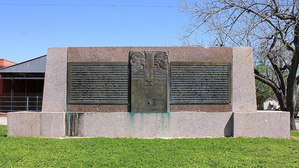
Built in 1938. Listed on the National Register of Historic Places in 2018.
One of 113 National Register listings published here for Victoria County · listed in 2018 · category: Object · built in 1938, by Page.
Sources: the National Register database, National Park Service
Regional context, not property-specific evidence. The federal wildfire occurrence database lists 260 fires within 5 miles of Victoria County Monument between 2005 and 2020, burning about 1,833 acres in total. None started naturally. 1 was recorded as arson. Distance is straight-line from the map coordinates, so a fire counted here may appear on a neighbouring settlement's page as well.
| Reported cause | Fires |
|---|---|
| Missing data/not specified/undetermined | 120 |
| Debris and open burning | 79 |
| Equipment and vehicle use | 24 |
| Power generation/transmission/distribution | 15 |
| Smoking | 9 |
| Railroad operations and maintenance | 5 |
| Recreation and ceremony | 4 |
| Misuse of fire by a minor | 3 |
| Arson/incendiarism | 1 |
The most recent of them, most recent first, with the day each was reported and the service that recorded it.
| Date | Cause | Size | Reported by | Name on the report |
|---|---|---|---|---|
| 9 September 2019 | Smoking | under an acre | Texas A & M Forest Service | MARRIOTT GRASS FIRE |
| 7 September 2017 | Missing data/not specified/undetermined | under an acre | Texas A & M Forest Service | SUTTON MOTT |
| 7 September 2017 | Missing data/not specified/undetermined | 1.0 acres | Texas A & M Forest Service | JUAN LINN 2 |
| 7 September 2017 | Missing data/not specified/undetermined | under an acre | Texas A & M Forest Service | SW MOODY |
| 30 September 2016 | Missing data/not specified/undetermined | 4.0 acres | Texas A & M Forest Service | MOODY |
| 29 September 2015 | Debris and open burning | under an acre | Texas A & M Forest Service | DELORAS |
| 29 September 2013 | Missing data/not specified/undetermined | 1.0 acres | Texas A & M Forest Service | GRASS FIRE |
| 26 September 2012 | Missing data/not specified/undetermined | under an acre | Texas A & M Forest Service | ZAC LENTZ PKWY |
Regional context, not property-specific evidence. The federal mineral resources record lists 4 workings within 5 miles of Victoria County Monument: 3 producers, 1 past producer. 3 still produce. What was taken out: Sand and Gravel, Construction. Distance is straight-line from the map coordinates, so a quarry counted here may appear on a neighbouring settlement's page as well.
| Where | Site | Commodity | Status | Recorded |
|---|---|---|---|---|
| Chipley Pit | Sand and Gravel, Construction | Producer | Gravel, Sand | |
| Fordyce Co Chipley Pit and Plant | Sand and Gravel, Construction | Producer | ||
| Unknown | Sand and Gravel, Construction | Past Producer | ||
| Victoria Pit & Plant | Sand and Gravel, Construction | Producer |
Regional context, not property-specific evidence. The National Weather Service names Victoria, the town this property stands in, in 117 storm reports between 1993 and 2025: 42 hail, 35 thunderstorm wind, 27 flash flood, 4 lightning. No death or injury is recorded in these reports. Each account below is quoted exactly as the forecast office filed it, from the NOAA Storm Events Database, and each date opens the federal record of that event.
| When | Event | Place named | Harm | What the report says |
|---|---|---|---|---|
| July 2007 | Flash Flood | Victoria | $1,000,000 | Widespread flash flooding occurred across much of Victoria county during the early morning. Between 2 and 4 inches of rain fell across the southern half of the county and between 4 and 8 inches fell across the northern half of the county, with isolated amounts between 8 and 11 inches. Flooding was reported at Benbow Road and Garcitas Creek and at U.S. 77 at Garcitas Creek, numerous roads throughout the city of Victoria and several Farm to Market Roads in the northern half of the county. U.S. 77 was closed from the north side of the city of Victoria to the Lavaca/De Witt/Victoria county line due to flooding at the county line and at least one vehicle was completely submereged in a high water crossing along U.S. 77. In Nursery, widespread flash flooding of creeks resulted in 25 homes with water in them as well as cars reported underwater. Up to 10 homes in the Tropical Acres subdivision of Victoria had water in them due to flash flooding of Spring Creek. Flooding of 3 homes along Benbow Road near Garcitas Creek also occured. Several evacuations of families were needed. |
| May 1993 | Thunderstorm Wind | Victoria | $50,000 | Several trees were reported blown down near Russel and Haynes roads in the City. After the first report of damage three other reported of trees damage were made from within the City. The Sheriff's Office reported power lines down on the Upper Mission Valley road. |
| July 2017 | Thunderstorm Wind | Victoria | $25,000 | Victoria County Sheriff's Office reported wind gusts estimated to around 60 mph in downtown Victoria. Trees and street signs were blown down. |
| August 2011 | Lightning | Victoria | $20,000 | Lightning caused two separate house fires in Victoria. The lightning blew out electrical panels and the fires damaged structures. |
| May 2022 | Thunderstorm Wind | Victoria | $10,000 | A power pole was blown down along with power lines down on East Virginia Street in Victoria. |
| July 2017 | Thunderstorm Wind | Victoria | $10,000 | Report received through social media of wind damage in downtown Victoria. A power pole was blown down and trees were damaged at the intersection of South Navarro Street and East Forrest Street. |
| March 2016 | Thunderstorm Wind | Victoria | $10,000 | Large trees were blown down on the road near Nimitz Street and Rosebud Avenue in Victoria. |
| April 2012 | Hail | Victoria | $10,000 | Stripes Convenience store employee reported quarter sized hail at U. S. Highway 59 and North Laurent Street. |
| August 2011 | Thunderstorm Wind | Victoria | $10,000 | Thunderstorm winds caused roof damage, blew down several trees, and blew over a small travel camper. |
| August 2005 | Lightning | Victoria | $10,000 | Lightning struck a home on Ridgewood in Victoria. Fire was contained to attic, but did cause smoke damage to remainder of the home. |
| March 2016 | Thunderstorm Wind | Victoria | $5,000 | A large tree was blow on to a mobile home on Leary Lane and damaged the home. |
| May 1994 | Thunderstorm Wind | Victoria | $5,000 | A gust to 53 knots was measured at an electronic weather station in Woodhigh. Pea-sized hail accompanied the strong winds. |
| May 1994 | Thunderstorm Wind | Victoria | $5,000 | Large tree limbs were knocked down and several trees were uprooted in Nursery. At 0120 CST the public reported wind damage to brick wall in a mobile home park in Victoria and several more trees uprooted in the Woodway area. |
| May 1993 | Thunderstorm Wind | Victoria | $5,000 | Several trees were reported blown down near Russel and Haynes roads in the City. After the first report of damage three other reported of trees damage were made from within the City. The Sheriff's Office reported power lines down on the Upper Mission Valley road. |
| May 2022 | Thunderstorm Wind | Victoria | $2,000 | Tree was blown down on the road near Delmar Drive and Lone Tree Road in Victoria. |
| April 2009 | Lightning | Victoria | $1,000 | Lightning struck the Victoria 911 call center. A backup system was used until the main system came back online at 4 AM. |
| June 2025 | Flash Flood | Victoria | - | Numerous streets flooded throughout the City of Victoria. |
| June 2025 | Heavy Rain | Victoria | - | Total rainfall accumulation of 7.05 inches. |
| June 2025 | Heavy Rain | Victoria | - | Total rainfall accumulation of 7.52 inches. |
| June 2025 | Heavy Rain | Victoria | - | Rainfall total of 6.03 inches since midnight. |
| September 2025 | Heavy Rain | Victoria | - | A total of 3.05 inches of rain measured between 1:00PM-4:40PM. |
| September 2025 | Flash Flood | Victoria | - | Flash flooding occurred due to heavy rainfall. |
| September 2025 | Flash Flood | Victoria | - | Flash flooding forced the closure of the Navarro Street underpass on Sunday, blocking traffic at the entrances on East North Street, Navarro Street and Goodwin Avenue. City officials said barricades were placed at all entry points to keep drivers out of high water. Crews are monitoring the area and will reopen the intersection once conditions improve. Police say the intersection could remain closed until Monday. |
| May 2024 | Hail | Victoria | - | Videos sent from Victoria Emergency Management observed large hail. |
| May 2024 | Hail | Victoria | - | Report from mPing. |
| December 2024 | Thunderstorm Wind | Victoria | - | A CWOP weather station in Victoria, TX measured a wind gust of 58 mph. |
| January 2023 | Flash Flood | Victoria | - | Flash flooding occurred on numerous roadways around Victoria. This included the Navarro Street and Laurent Street Underpasses, the Five Points area, and Crestwood Drive and Ben Jordan Street. |
| July 2022 | Flash Flood | Victoria | - | Broadcast meteorologist shared a public photo of street flooding in northwest Victoria. |
| August 2011 | Thunderstorm Wind | Victoria | - | Winds downed pine tree 8 to 10 inches in diameter. |
| July 2010 | Funnel Cloud | Victoria | - | A funnel cloud was observed near Port Lavaca Highway and Ben Jordan, in Victoria. |
| April 2010 | Flash Flood | Victoria | - | Several inches of flowing water was reported at a low water crossing on Briggs Blvd. Minor flooding of roadways was reported elsewhere through the city. |
| September 2010 | Flash Flood | Victoria | - | Public reported water over the roadways in portions of the city of Victoria near Mockingbird Lane. |
| September 2010 | Funnel Cloud | Victoria | - | Law enforcement reported a funnel cloud near the Victoria Community Center. |
| June 2009 | Hail | Victoria | - | Reported at the Victoria Advocate Newspaper. |
| June 2009 | Hail | Victoria | - | Nicle size hail reported at Memorial High School. |
| June 2009 | Hail | Victoria | - | Nickle size hail repoted by KAVU. |
| June 2009 | Hail | Victoria | - | Nickle size hail reported by Fire Chief. |
| June 2009 | Hail | Victoria | - | Pea to nickle size hail reported by public. |
| June 2009 | Hail | Victoria | - | Quarter size hail reported along U.S. 59. |
| June 2009 | Thunderstorm Wind | Victoria | - | Several 3 to 4 inch diameter tree limbs snapped. |
| June 2009 | Hail | Victoria | - | Quarter sized hail reported at Port Lavaca Highway and Laurent Street. |
| March 2008 | Hail | Victoria | - | Observed at Citizens Medical Center in Victoria. |
| March 2008 | Flash Flood | Victoria | - | Flash flooding occurred in the city of Victoria when 2-4 inches of rain fell over a two hour period. Several low water crossings and underpasses were flooded, with cars reported stalled. |
| March 2007 | Hail | Victoria | - | Nickle sized hail fell for 10 minutes on the southeast side of Victoria, near Business 59 and Loop 463.| |
| July 2007 | Flash Flood | Victoria | - | Between 1 and 3 inches of rainfall fell during the early morning across central Victoria county. City streets in Victoria flooded around Second Street and Liberty and Second Street and Williams. At least 10 homes had up to 6 inches of water in them from the flooding.| |
| March 2007 | Thunderstorm Wind | Victoria | - | Straight line winds broke several large tree limbs across the north side of Victoria. A few fences were also blown over. |
| March 2007 | Flash Flood | Victoria | - | Flooding was reported on many roads in the city of Victoria, including Navarro at Rio Grande, Ben Wilson St. near the University of Houston-Victoria and the Laurent Street underpass.| |
| September 2007 | Flash Flood | Victoria | - | The underpass at 900 North Loran Street in Victoria was completely flooded with several feet of water and impassable. Additional city streets were flooded, including Sam Houston, Lilac and Mockinbird with several vehicles stranded.| |
| May 2006 | Tornado (F0) | Victoria | - | Tornado observed by newspaper reporter between Guadalupe and Wood Hi, over open rural country. |
| May 2006 | Hail | Victoria | - | Reported at Hanselman and U.S. 59. |
| May 2006 | Flash Flood | Victoria | - | Lorent Street underpass at Highway 185 flooded with roughly two feet of water. |
| May 2006 | Flash Flood | Victoria | - | Red River Road became impassible from Laurent to Nimitz and Ben Wilson from Red River to Airline. N. Laurent Street at the railroad overpass also became impassible with high water. |
| June 2006 | Flash Flood | Victoria | - | Doppler radar estimated showers and thunderstorms produced an isolated 3 to 5 inches of rainfall in the southern portion of Victoria County. Old Refugio Road at U.S. 77 was reported barricaded due to high water over the road. |
| May 2005 | Hail | Victoria | - | Quarter-sized hail on north side of city. |
| May 2005 | Hail | Victoria | - | Minor hail damage reported to cars. |
| May 2005 | Lightning | Victoria | - | Lightning struck a tank battery near Ragsdale Road in eastern Victoria County. The tank was destroyed and flames were sent 100 feet into the air. The time of 1900 CST was roughly estimated from media reports. |
| July 2005 | Flash Flood | Victoria | - | Heavy rainfall resulted in low water crossings flooded on the southeast side of Victoria, including Lone Tree Road. NWS radar estimated between 1 and 3 inches of rainfall fell in about 1 hour. |
| October 2005 | Hail | Victoria | - | Quarter size hail at U.S. 77 and Hwy 444 in far northern Victoria County. |
| June 2004 | Flash Flood | Victoria | - | Flooding occurred on several city streets in the city of Victoria. 0.89 inches of rain was recorded at the Victoria Regional Airport, however radar estimated up to 2 inches may have fallen quickly in other areas in and around Victoria. |
| June 2004 | Flash Flood | Victoria | - | Heavy rainfall resulted in flooding along Highway 185 just south of Victoria. Radar estimated 2 to 3 inches of rain fell across southern portions of Victoria county. |
No historic map-sheet match is published for this property yet. That does not mean no map exists. This record needs a coordinate-quality review before it can be joined to a sheet boundary. Browse the county's mapped places while that work is pending.
Other National Register properties close enough to walk or drive between, ordered by distance from this one. Both positions come from the same geocoding pass that matched these properties to their map sheets.
| Photograph | Property | Distance | Listed |
|---|---|---|---|
 | Schummacker Company Building | under 500 feet | 1986 |
 | House at 401 East Stayton | under 500 feet | 1986 |
 | Victoria Grist Windmill | under 500 feet | 1976 |
 | Jordan-Koch House | under 500 feet | 1986 |
 | Gervais House | 0.1 miles | 1990 |
 | Gramann House | 0.1 miles | 1986 |
| National Archives record | The nomination case file for reference 100002760 in Record Group 79. |
| Victoria County | All 113 listed properties in this county. |