 Block
BlockFrom the record
One of 8 National Register listings published here for Fort Bend County · listed in 2014 · category: Building.
Sources: the National Register database, National Park Service
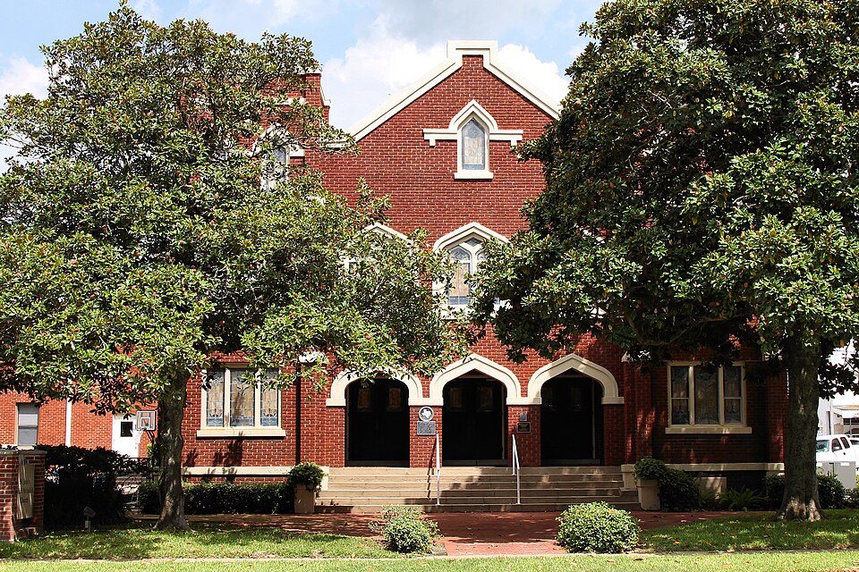
Listed on the National Register of Historic Places in 2014.
One of 8 National Register listings published here for Fort Bend County · listed in 2014 · category: Building.
Sources: the National Register database, National Park Service
Regional context, not property-specific evidence. The federal wildfire occurrence database lists 13 fires within 5 miles of Methodist Church of Richmond between 2003 and 2017, burning about 82 acres in total. 1 started naturally. 2 were recorded as arson. Distance is straight-line from the map coordinates, so a fire counted here may appear on a neighbouring settlement's page as well.
| Reported cause | Fires |
|---|---|
| Missing data/not specified/undetermined | 4 |
| Debris and open burning | 4 |
| Power generation/transmission/distribution | 2 |
| Arson/incendiarism | 2 |
| Natural | 1 |
The most recent of them, most recent first, with the day each was reported and the service that recorded it.
| Date | Cause | Size | Reported by | Name on the report |
|---|---|---|---|---|
| 11 September 2011 | Arson/incendiarism | 5.0 acres | Texas A & M Forest Service | CLAY ST |
| 3 August 2003 | Debris and open burning | 4.0 acres | Texas A & M Forest Service | CONROE - 62 |
| 15 August 2011 | Missing data/not specified/undetermined | 3.0 acres | Texas A & M Forest Service | GRASS FIRE |
| 25 July 2011 | Missing data/not specified/undetermined | under an acre | Texas A & M Forest Service | GRASS FIRE |
| 6 June 2011 | Natural | 10 acres | Texas A & M Forest Service | GRASS FIRE |
| 29 June 2013 | Debris and open burning | 5.0 acres | Texas A & M Forest Service | 715 SECR 1190 |
| 8 May 2011 | Missing data/not specified/undetermined | under an acre | Texas A & M Forest Service | GRASS FIRE |
| 28 May 2011 | Arson/incendiarism | under an acre | Texas A & M Forest Service | GRASS FIRE |
Regional context, not property-specific evidence. The federal mineral resources record lists 10 workings within 5 miles of Methodist Church of Richmond: 6 past producers, 4 producers. 4 still produce. What was taken out: Sand and Gravel, Construction. Distance is straight-line from the map coordinates, so a quarry counted here may appear on a neighbouring settlement's page as well.
| Where | Site | Commodity | Status | Recorded |
|---|---|---|---|---|
| Unknown | Sand and Gravel, Construction | Past Producer | ||
| Unknown | Sand and Gravel, Construction | Past Producer | ||
| Unknown | Sand and Gravel, Construction | Past Producer | ||
| Unknown | Sand and Gravel, Construction | Past Producer | ||
| Unknown | Sand and Gravel, Construction | Past Producer | ||
| Unknown | Sand and Gravel, Construction | Past Producer | ||
| Unnamed Dredging Corporation | Sand and Gravel, Construction | Producer | Gravel, Sand | |
| Unnamed Pit | Sand and Gravel, Construction | Producer | Sand | |
| Unnamed Pit | Sand and Gravel, Construction | Producer | Gravel, Sand | |
| Unnamed Pit | Sand and Gravel, Construction | Producer | Gravel, Sand |
Regional context, not property-specific evidence. The National Weather Service names Richmond, the town this property stands in, in 35 storm reports between 1996 and 2023: 12 thunderstorm wind, 11 hail, 6 flash flood, 3 lightning. No death or injury is recorded in these reports. Each account below is quoted exactly as the forecast office filed it, from the NOAA Storm Events Database, and each date opens the federal record of that event.
| When | Event | Place named | Harm | What the report says |
|---|---|---|---|---|
| April 2001 | Thunderstorm Wind | Richmond | $100,000 | Roof was torn off a mobile home. |
| May 2000 | Thunderstorm Wind | Richmond | $100,000 | Numerous trees and signs blown down in area. Small building destroyed at Cottonwood with barn blown down on Psencik Road. Power poles down at Cottonwood and on Band Road. |
| March 2002 | Hail | Richmond | $75,000 | Quarter sized hail occurred in the Pecan Grove Plantation subdivision, reported by a ham radio operator. |
| January 2012 | Flash Flood | Richmond | $30,000 | Heavy rains produced flash flooding across portions of Fort Bend County from the Richmond area to the Sugar Land area. Boat rescues were needed due to submerged vehicles and stranded motorists. |
| June 2006 | Thunderstorm Wind | Richmond | $25,000 | Trees and a fence down in the Pecan Creek Subdivision near the intersection of FM Road 359 and FM Road 723. |
| January 2020 | Thunderstorm Wind | Richmond | $18,000 | There was some roof damage to the Richmond Police Department building. In the nearby park, several trees lost limbs or were blown down. |
| August 2010 | Thunderstorm Wind | Richmond | $12,000 | Thunderstorm winds uprooted a tree that damaged a concrete path at the Fort Bend Country Club. There were also reports of roof and water line damage. |
| June 1996 | Thunderstorm Wind | Richmond | $10,000 | no account filed |
| June 1996 | Hail | Richmond | $10,000 | no account filed |
| August 2010 | Thunderstorm Wind | Richmond | $8,000 | Thunderstorm wind gusts damaged windows at Hutchinson Elementary School. |
| February 2012 | Flash Flood | Richmond | $5,000 | Water was over the roads along FM 359 and Pitts Road near Melody Lane. Water was rising and threatening residences as nearby creeks were at bankfull. |
| March 2007 | Hail | Richmond | $5,000 | Penny size hail. |
| October 2006 | Lightning | Richmond | $5,000 | A lightning strike caused damage to a residential home. |
| June 1998 | Thunderstorm Wind | Richmond | $5,000 | Downburst downed trees. |
| May 1996 | Thunderstorm Wind | Richmond | $5,000 | no account filed |
| June 1996 | Hail | Richmond | $5,000 | no account filed |
| March 2005 | Hail | Richmond | $4,000 | Hail reported at intersection of Highways 90 and 36. |
| August 2010 | Thunderstorm Wind | Richmond | $3,000 | Power lines were downed at FM 359 and Plantation Road. |
| March 2013 | Hail | Richmond | $1,000 | Half dollar size hail fell on Thomson Crossing Drive. The hail damaged a residential home including a cracked window. |
| March 2007 | Thunderstorm Wind | Richmond | $1,000 | Tree down. |
| March 2007 | Hail | Richmond | $1,000 | Penny-size hail. |
| April 2007 | Lightning | Richmond | $1,000 | Lightning strike at Richmond Police Department. Lightning struck an antique 1897 flag pole atop building and exploded it into several splinters. One 4 foot section of the pole was reported to have embedded itself in the ground across the street from the police station. |
| October 2006 | Lightning | Richmond | $1,000 | A lightning strike caused minimal damage to a residential home. |
| April 2023 | Hail | Richmond | - | There was quarter sized hail in the Pecan Grove area. |
| October 2021 | Flash Flood | Richmond | - | Heavy rainfall resulted in the US 90 underpass at Thompson Rd becoming impassable due to floodwaters. |
| May 2019 | Flash Flood | Richmond | - | There was street flooding and road closures in the town of Richmond. |
| April 2017 | Flash Flood | Richmond | - | The intersection of U.S. Highway 59 and FM 762 was flooded. |
| August 2017 | Flash Flood | Richmond | - | Sections of FM 762 were flooded around SH 69 south of Richmond.||Major record level flooding of both the Brazos and San Bernard Rivers caused significant home flooding from Richmond to Rosharon. Massive flooding occurred in Tierra Grande subdivision along the San Bernard River in southwestern Fort Bend County. Home flooding occurred at Valley Lodge in Simonton, along Edgewood and Baudet Roads in Richmond, along Bar, Barker, Cumings, Sixth Street, Avenue B and Rio Brazos Roads in Rosenberg. Sections of FM 2759 as well as the Grand River, Rivers Edge and Pecan Estates in Thompsons flooded. Many countywide roads became inundated in flood waters including, but not limited to, Highway 90A, Pitts Road, FM 1489, FM 723, FM 1093, FM 359, SH 6 feeder roads, Sienna Parkway, Carrol Road, McKeever Road, Knights Court, Miller Road, river Oaks Road, Thompsons Ferry Road, Strange Drive, Greenwood Drive, Second Street and low lying roads in Quail Valley in Missouri City. Due to record pool levels in Barker Reservoir, homes in Cinco Ranch flooded. Big Creek flooding in Needville caused the flooding of homes on Ansel Road. |
| April 2015 | Hail | Richmond | - | Golf ball sized hail was reported in Richmond. |
| August 2015 | Hail | Richmond | - | Nickel sized hail was reported. |
| August 2015 | Hail | Richmond | - | Quarter sized hail was reported. |
| October 2013 | Heavy Rain | Richmond | - | Heavy rain caused street flooding in the town of Richmond. |
| August 2010 | Thunderstorm Wind | Richmond | - | A spotter reported strong winds that were lifting shingles off residences. |
| July 2008 | Funnel Cloud | Richmond | - | The funnel cloud was sighted near the intersection of US 90 and FM 359. |
| May 2001 | Funnel Cloud | Richmond | - | no account filed |
No historic map-sheet match is published for this property yet. That does not mean no map exists. This record needs a coordinate-quality review before it can be joined to a sheet boundary. Browse the county's mapped places while that work is pending.
Other National Register properties close enough to walk or drive between, ordered by distance from this one. Both positions come from the same geocoding pass that matched these properties to their map sheets.
| Photograph | Property | Distance | Listed |
|---|---|---|---|
 | Fort Bend County Courthouse | under 500 feet | 1980 |
 | John M. and Lottie D. Moore House | under 500 feet | 2001 |
 | Lamar-Calder House | 0.3 miles | 2005 |
| Holy Rosary Catholic Church | 3.9 miles | 2022 | |
 | Imperial Sugar Company Refinery Historic District | 8.0 miles | 2017 |
| National Archives record | The nomination case file for reference 14000339 in Record Group 79. |
| Fort Bend County | All 8 listed properties in this county. |