BlockBefore
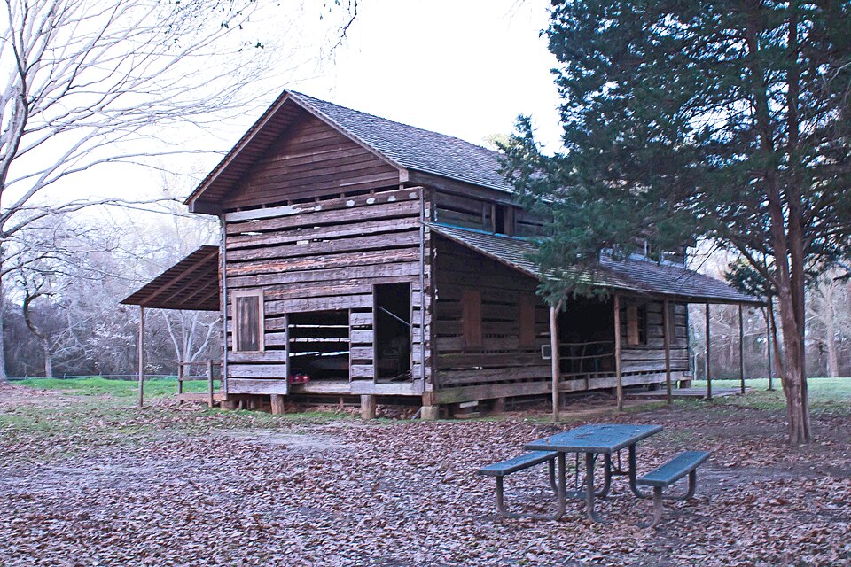
Photograph of Gaines-Oliphint House
Photograph by Renelibrary, CC BY-SA 4.0. Via Wikimedia Commons.

Oliphant House

Listed on the National Register of Historic Places in 1977.

From the record

One of 2 National Register listings published here for Sabine County · listed in 1977 · category: Building.

Sources: the case file at the National Archives · the National Register database, National Park Service · the Wikipedia article

The listing

  • What is counted as historic. The nomination lists 1 building as contributing to the listing.
  • Address. 7 mi. E of Milam off TX 21, Milam, 75948
  • When was it listed? August 1977
  • Category. building
  • Census division. Milam
  • National Register reference number. 77001473 - the number the National Park Service assigned this property when it was listed, and the key its nomination file is catalogued under at the National Archives.

Fires near this property

143 since 1992

Regional context, not property-specific evidence. The federal wildfire occurrence database lists 143 fires within 5 miles of Oliphant House between 1992 and 2020, burning about 1,376 acres in total. 7 started naturally. 25 were recorded as arson. Distance is straight-line from the map coordinates, so a fire counted here may appear on a neighbouring settlement's page as well.

Reported cause Fires
Debris and open burning56
Arson/incendiarism25
Power generation/transmission/distribution15
Missing data/not specified/undetermined15
Recreation and ceremony12
Natural7
Equipment and vehicle use6
Smoking5
Misuse of fire by a minor1
Other causes1

The most recent of them, most recent first, with the day each was reported and the service that recorded it.

DateCause SizeReported by Name on the report
5 September 2015Missing data/not specified/undeterminedunder an acreTexas A & M Forest Service7099
4 September 2006Arson/incendiarism16 acresNational Forests And Grasslands In TexasALLEN CREEK
29 September 1993Debris and open burning4.0 acresTexas A & M Forest Servicenot named
23 September 2005Arson/incendiarism24 acresNational Forests And Grasslands In TexasALPINE
21 September 2006Missing data/not specified/undetermined2.0 acresTexas A & M Forest Servicenot named
20 September 2006Missing data/not specified/undetermined2.0 acresTexas A & M Forest Servicenot named
19 September 2005Arson/incendiarism1.0 acresTexas A & M Forest ServiceWOODVILLE - 235
13 September 2012Debris and open burningunder an acreTexas A & M Forest Service12.09.13F1

Every fire recorded in Sabine County

Storms near this property

32 since 1995

Regional context, not property-specific evidence. The National Weather Service names Milam, the town this property stands in, in 32 storm reports between 1995 and 2025: 20 thunderstorm wind, 5 hail, 4 tornado, 3 flash flood. The reports record 1 injury. Each account below is quoted exactly as the forecast office filed it, from the NOAA Storm Events Database, and each date opens the federal record of that event.

WhenEvent Place namedHarm What the report says
May 2009Thunderstorm WindMilam1 hurt, $40,000A tree fell on a trailer at Alpine Marina on Hwy. 21. There was an injured man reported in the trailer from the fallen tree.
July 2024Tornado (EF1)Milam$85,000An EF-1 tornado with estimated maximum winds near 110 mph touched down along the western sections of Toledo Bend Reservoir near Holly Park Marina off of Carters Ferry Road. The tornado initially touched down as a waterspout on Toledo Bend, before moving ashore just south of Holly Park Marina, where it tossed and overturned a couple of RV's at an RV park. The tornado also threw a few boats, destroyed a boat dock, and a small fish cleaning station while also snapping a number of large hardwood trees. The tornado then moved back out over the open water before coming back ashore south of Nine Mile Road. Numerous trees were snapped and uprooted along East Hamilton Road as well as nearby privately owned land, before the tornado again moved back over the water and lifted.
June 2012Thunderstorm WindMilam$10,000Wind damage was reported at Holly Park near the Toledo Bend Reservoir.
June 2009Thunderstorm WindMilam$10,000Several trees were downed along with power lines. One tree was down across a car in the northern portion of the county. No injuries were reported.
March 2008Tornado (EF0)Milam$1,000An EF0 tornado with winds of 65 to 70 mph occurred approximately 1.5 miles southwest of Milam, Texas in Sabine County, Texas along a path approximately 50 yards wide and 2 miles long. Several large trees were snapped off or uprooted along the path which originated along Dorsey Road extending northeastward across Hwy. 21 before lifting. Smaller limbs were broken along the path as well.
June 2025Thunderstorm WindMilam-Several trees downed on Dorsey Road.
June 2025Thunderstorm WindMilam-Tree downed on FM Road 1592.
June 2025Thunderstorm WindMilam-Tree downed on Highway 21 near Cedar Grove Road.
June 2025Thunderstorm WindMilam-Tree downed on Highway 21 near FM Road 3121.
June 2024Thunderstorm WindMilam-Two trees downed near the intersection of Highway 87 North and Telephone Road.
May 2024Thunderstorm WindMilam-Widespread power outages reported with downed trees and power lines in Milam.
July 2022Thunderstorm WindMilam-Trees downed near the intersection of Highway 21 and Highway 103 west of Milam.
May 2021Thunderstorm WindMilam-Trees were downed in the Pendleton Harbor community.
May 2021Flash FloodMilam-Several streets were flooded near Milam.
April 2020Thunderstorm WindMilam-A large tree was downed in Milam.
July 2018Thunderstorm WindMilam-Trees were downed near FM 3121 and Pecan Estates Loop east of Milam.
July 2018Tornado (EF0)Milam-A photo of a waterspout was taken from the Highway 6 bridge over the Toledo Bend Reservoir on the Sabine Parish Louisiana side and posted to Facebook. This waterspout touched down just inside Sabine County Texas, was brief in duration, and did not cause any damage before dissipating.
May 2017Flash FloodMilam-High water resulted in the closure of Hwy. 3121 northeast of Hemphill, Texas.
August 2017Flash FloodMilam-Davidson Road was washed out and impassable.
July 2016Thunderstorm WindMilam-Several trees were downed north of Hemphill Texas.
March 2013Thunderstorm WindMilam-A few trees were downed in the town of Milam, Texas.
June 2012Thunderstorm WindMilam-Trees were downed along Hwy. 21 near Geneva, Texas.
August 2008Thunderstorm WindMilam-Powerlines were downed in the community of Mid Lake, Texas.
November 2007HailMilam-Hail fell north of Milam.
May 2006HailMilam-Hail reported on Hwy 87.
May 1999Thunderstorm WindMilam-Numerous trees down across Hwy 87.
July 1997Thunderstorm WindMilam-Trees and power lilnes were downed along Hwy 276 leading to numerous electrical outages.
December 1995Tornado (F0)Milam-Sheriff's office reported the tornado crossing over Toledo Bend Lake.
March 2008HailMilam-no account filed
February 1998Thunderstorm WindMilam-no account filed

Every storm recorded in Sabine County

Map coverage status

No historic map-sheet match is published for this property yet. That does not mean no map exists. This record needs a coordinate-quality review before it can be joined to a sheet boundary. Browse the county's mapped places while that work is pending.

Sources for this property

National Archives recordThe nomination case file for reference 77001473 in Record Group 79.
Wikipedia articleCommunity-written account of this property, licensed CC BY-SA.
Sabine CountyAll 2 listed properties in this county.

Provenance

  • Listing record. National Park Service National Register of Historic Places, listed-properties dataset, current to 2026-05-22.
  • Map join. Address geocoded through the United States Census geocoder, then tested against the published boundary of every sheet in the USGS Historical Topographic Map Collection.
  • How this page is made. Listing fields come from federal records; map-sheet coverage is a labelled coordinate-to-boundary calculation, not a source-field claim.
  • Wildfire. Short, Karen C. 2022. Spatial wildfire occurrence data for the United States, 1992-2020 [FPA_FOD_20221014]. 6th Edition. Fort Collins, CO: Forest Service Research Data Archive. https://doi.org/10.2737/RDS-2013-0009.6 Collected with United States Government funding and usable without additional permissions or fees.
  • Storms. NOAA National Centers for Environmental Information, Storm Events Database https://www.ncei.noaa.gov/stormevents/ A work of the United States government, no copyright under 17 U.S.C. 105. Narratives are quoted verbatim from the National Weather Service report and are not edited or summarised.