 Block
BlockFrom the record
One of 101 National Register listings published here for Bastrop County · listed in 1978 · category: Building.
Sources: the case file at the National Archives · the National Register database, National Park Service
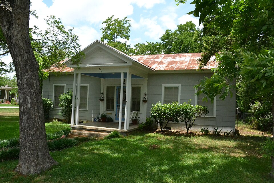
Listed on the National Register of Historic Places in 1978.
One of 101 National Register listings published here for Bastrop County · listed in 1978 · category: Building.
Sources: the case file at the National Archives · the National Register database, National Park Service
Regional context, not property-specific evidence. The federal wildfire occurrence database lists 437 fires within 5 miles of House at 604 Elm between 1992 and 2020, burning about 1,533 acres in total. 16 started naturally. 26 were recorded as arson. Distance is straight-line from the map coordinates, so a fire counted here may appear on a neighbouring settlement's page as well.
| Reported cause | Fires |
|---|---|
| Debris and open burning | 237 |
| Missing data/not specified/undetermined | 98 |
| Equipment and vehicle use | 27 |
| Arson/incendiarism | 26 |
| Natural | 16 |
| Recreation and ceremony | 11 |
| Misuse of fire by a minor | 10 |
| Power generation/transmission/distribution | 6 |
| Smoking | 6 |
The most recent of them, most recent first, with the day each was reported and the service that recorded it.
| Date | Cause | Size | Reported by | Name on the report |
|---|---|---|---|---|
| 7 September 2015 | Missing data/not specified/undetermined | under an acre | Texas A & M Forest Service | 1513 FAYETTE ST |
| 6 September 2006 | Missing data/not specified/undetermined | 15 acres | Texas A & M Forest Service | MCALLISTER ROAD - 184 |
| 5 September 2015 | Missing data/not specified/undetermined | under an acre | Texas A & M Forest Service | 1000 95 HWY N |
| 4 September 2019 | Equipment and vehicle use | 4.9 acres | Texas A & M Forest Service | TACO TRUCK |
| 3 September 2002 | Debris and open burning | 8.0 acres | Texas A & M Forest Service | CENTRAL TX - 37 |
| 26 September 1997 | Missing data/not specified/undetermined | 1.0 acres | Texas A & M Forest Service | not named |
| 22 September 2008 | Debris and open burning | under an acre | Texas A & M Forest Service | not named |
| 20 September 2008 | Debris and open burning | under an acre | Texas A & M Forest Service | not named |
Regional context, not property-specific evidence. The National Weather Service names Bastrop, the town this property stands in, in 68 storm reports between 1993 and 2024: 29 hail, 24 thunderstorm wind, 14 flash flood, 1 flood. The reports record 1 death. Each account below is quoted exactly as the forecast office filed it, from the NOAA Storm Events Database, and each date opens the federal record of that event.
| When | Event | Place named | Harm | What the report says |
|---|---|---|---|---|
| November 2002 | Flash Flood | Bastrop | 1 killed | A Bastrop woman was swept away in her car as she attempted to drive through the Cedar Creek crossing at Lower Red Rock Road, just off FM304 southwest of Bastrop. She called police at 0525CST to say that she had driven into deep water and the car was beginning to flood. She was rescued by emergency personnel but died shortly afterward at the Smithville hospital. |
| May 2015 | Flash Flood | Bastrop | $2,000,000 | Thunderstorms produced heavy rain that caused flash flooding in Bastrop. A 1000 foot long earthen dam holding a small fishing pond in Bastrop State Park ruptured. In addition multiple roads were closed across the county. Damage to infrastructure likely exceeded 2 million dollars. |
| August 2017 | Flood | Bastrop | $1,500,000 | A number of places in Fayette, Lavaca, and Bastrop Counties received 20 or more inches of rain. Tropical storm force winds with estimated gusts up to 60 mph caused damage across the region. Trees and branches were knocked down by the winds. Some of these in turn knocked down power lines causing power outages. 100 People were evacuated in Bastrop County. Rainfall over the far western side of Bastrop County was about 12 inches, while the Smithville area had a 7 day rain total of nearly 24 inches. The Colorado River at Smithville crested near 32 feet on August 28, flooding about 60 homes in the Smithville area. There were about 150 low water crossings underwater and many roads were damaged. Overall estimates to damage in the county are about 1.5 million dollars, about a million of that coming from damage to roads and bridges. |
| September 1997 | Thunderstorm Wind | Bastrop | $90,000 | no account filed |
| June 2003 | Thunderstorm Wind | Bastrop | $80,000 | The Bastrop Sheriff's Department reported that severe thunderstorm winds had blown down trees and knocked over power lines in Bastrop. |
| April 1997 | Thunderstorm Wind | Bastrop | $50,000 | Winds damaged numerous roofs and trees. |
| August 2003 | Thunderstorm Wind | Bastrop | $20,000 | A severe thunderstorm produced damaging winds as it approached Bastrop. The severe winds knocked down several trees. |
| September 1997 | Thunderstorm Wind | Bastrop | $20,000 | no account filed |
| May 1999 | Thunderstorm Wind | Bastrop | $15,000 | Trees were blown over and large limbs knocked down by high winds. |
| May 2024 | Thunderstorm Wind | Bastrop | $10,000 | A thunderstorm produced wind gusts estimated at 65 mph that damaged a carport and barn roof on the westside of Bastrop. The carport was ripped from the building. |
| September 1996 | Thunderstorm Wind | Bastrop | $10,000 | no account filed |
| June 2019 | Thunderstorm Wind | Bastrop | $5,000 | A thunderstorm produced wind gusts estimated at 70 mph that downed multiple trees in and around Bastrop. |
| May 2019 | Thunderstorm Wind | Bastrop | $5,000 | A thunderstorm produced wind gusts estimated at 70 mph. These winds knocked down several trees and caused power outages near the intersection of Hwy 95 and Chestnut St. in Bastrop. |
| April 2018 | Thunderstorm Wind | Bastrop | $5,000 | A thunderstorm produced wind gusts estimated at 60 mph that tore the roof off a mobile home just east of downtown Bastrop. |
| May 2024 | Thunderstorm Wind | Bastrop | $2,000 | A thunderstorm produced wind gusts estimated at 60 mph that blew down some three inch diameter tree limbs on the west side of Bastrop. |
| August 2009 | Thunderstorm Wind | Bastrop | $2,000 | A thunderstorm produced wind gusts, estimated at 45 knots, that blew down numerous trees in Bastrop. |
| June 2010 | Thunderstorm Wind | Bastrop | $500 | A thunderstorm produced wind gusts estimated at 50 mph which knock down several tree limbs. |
| April 2024 | Hail | Bastrop | - | A thunderstorm produced quarter to chicken egg size hail in Bastrop. |
| April 2024 | Hail | Bastrop | - | A thunderstorm produced quarter size hail in Bastrop. |
| April 2024 | Hail | Bastrop | - | A thunderstorm produced ping pong ball size hail behind the HEB in the Riverside Grove neighborhood in Bastrop. |
| April 2024 | Hail | Bastrop | - | A thunderstorm produced quarter size hail in Bastrop. |
| April 2023 | Hail | Bastrop | - | A thunderstorm produced quarter size hail in Bastrop. |
| April 2023 | Thunderstorm Wind | Bastrop | - | A thunderstorm produced wind gusts estimated at 60 mph that caused sporadic tree and fence damage along a path from the 2800 block of N. Main St. to the 200 block of Sayers Rd. in Bastrop. |
| March 2022 | Hail | Bastrop | - | A thunderstorm produced nickel size hail near Bastrop State Park. |
| September 2021 | Thunderstorm Wind | Bastrop | - | A thunderstorm produced wind gusts estimated at 65 mph that knocked down tree branches from two to five inches in diameter in Bastrop. |
| April 2019 | Hail | Bastrop | - | A thunderstorm produced one inch hail in Bastrop. |
| June 2019 | Hail | Bastrop | - | A thunderstorm produced one inch hail in Bastrop. |
| March 2016 | Thunderstorm Wind | Bastrop | - | A thunderstorm produced wind gusts estimated at 60 mph that blew down a number of residential fences. |
| April 2016 | Thunderstorm Wind | Bastrop | - | A thunderstorm produced wind gusts estimated at 70 mph that tore roofs off and blew windows out of numerous houses, knocked down numerous trees and power lines, and caused structural damage to houses and businesses. |
| April 2016 | Thunderstorm Wind | Bastrop | - | A thunderstorm produced wind gusts estimated at 70 mph that snapped or blew down numerous large trees some of which were 40 feet tall. |
| April 2016 | Flash Flood | Bastrop | - | Thunderstorms produced heavy rain that caused flash flooding closing several roads in central Bastrop. |
| May 2016 | Flash Flood | Bastrop | - | Thunderstorms produced heavy rain that caused flash flooding closing Hwy 71 in multiple locations across the county. |
| May 2016 | Flash Flood | Bastrop | - | Thunderstorms produced heavy rain that caused flash flooding closing Hwy 71 east of Tahitian Dr. and Hwy 21 near Norfolk Dr. |
| May 2013 | Flash Flood | Bastrop | - | Thunderstorms produced heavy rain that caused flash flooding closing several roads in Bastrop. |
| April 2013 | Flash Flood | Bastrop | - | Thunderstorms produced heavy rain that caused flash flooding closing multiple roads in Bastrop. The Lower Colorado River Authority rain gauge at Smithville recorded 3.50 inches of rain in the three hours ending at 15:57 CST. |
| May 2012 | Flash Flood | Bastrop | - | Thunderstorms produced heavy rain that flooded a home on Pine Hill Loop in Bastrop. |
| January 2012 | Flash Flood | Bastrop | - | Thunderstorms produced heavy rain which caused flooding in Bastrop. People were rescued from a submerged car on Highway 71. A CoCoRAHS observer west-northwest of Bastrop reported 9.35 inches of rain from these storms. |
| March 2012 | Flash Flood | Bastrop | - | Thunderstorms produced heavy rain that caused flash flooding of numerous low water crossings around Bastrop. |
| May 2011 | Thunderstorm Wind | Bastrop | - | A thunderstorm produced wind gusts estimated at 50 knots which blew down a few trees in the Bastrop area. |
| August 2010 | Thunderstorm Wind | Bastrop | - | Thunderstorms produced wind gusts estimated at 60 mph. These winds blew out the windows of a CVS Pharmacy at the intersection of SH95 and SH71, caused major damage to the roof of the appraisal district building, moderate damage to the roof of the Bastrop County Sheriff's office, a gas leak from an air conditioning unit being damaged, and knocked down numerous trees and power lines. |
| February 2008 | Hail | Bastrop | - | The Bastrop County sheriff's office reported penny size hail. |
| February 2008 | Hail | Bastrop | - | A trained spotter reported one and one quarter inch hail. |
| February 2008 | Hail | Bastrop | - | A trained spotter reported quarter size hail. |
| July 2007 | Flash Flood | Bastrop | - | Thunderstorms dropped 2 to 3 inch amounts over southern Bastrop County, with up to 5 inches near Rosanky. Flash flooding closed sections of US290 and SH21. |
| August 2007 | Flash Flood | Bastrop | - | Showers and thunderstorms associated with Erin produced general 2 to 3 inch amounts across Bastrop County, with up to 4 inches near Elgin. FM1704 and SH95 were closed through mid-morning due to flash flooding. |
| June 2007 | Thunderstorm Wind | Bastrop | - | Severe thunderstorms winds produced large hail and blew down trees and knocked over power lines in the Bastrop area. |
| June 2004 | Flash Flood | Bastrop | - | Rainfall over Bastrop County averaged near 1 inch with the heaviest rain in the Bastrop area, where over 3 inches fell. Roads in and around Bastrop were under water from late afternoon into the evening |
| October 2004 | Flash Flood | Bastrop | - | Between 1 and 2 inches of rain fell between Bastrop and Cedar Creek during the morning, with some areas receiving over 3 inches. Flash flooding developed quickly and closed FM812 through the rest of the morning. |
| November 2004 | Thunderstorm Wind | Bastrop | - | Amateur radio operators reported that severe thunderstorms winds blew down trees along SH71 about 10 miles southeast of Bastrop. No other damage was reported. |
| November 1994 | Thunderstorm Wind | Bastrop | - | Winds estimated at over 60 mph knocked down several trees near Bastrop. The combination of strong winds and wet highways caused one vehicle to be washed off a road. Five inches of rain was produced by the storm, causing flash flooding across numerous county roads. Most of the damage from the storm was due to the washing out of roads. |
| March 1993 | Hail | Bastrop | - | Half-dollar-size hail was reported in Utley by a weather observer. As a second areas of thunderstorms moved into the county, quarter-size hail was reported between Elgin and Bastrop. Five minutes later the Elgin Police reported quarter-size hail just south of Elgin. Hail up to softball-size was reported in Paige. At least one car had its windshield knocked out. |
| April 2022 | Hail | Bastrop | - | no account filed |
| March 2014 | Hail | Bastrop | - | no account filed |
| March 2014 | Hail | Bastrop | - | no account filed |
| March 2014 | Hail | Bastrop | - | no account filed |
| March 2013 | Hail | Bastrop | - | no account filed |
| March 2013 | Hail | Bastrop | - | no account filed |
| June 2007 | Hail | Bastrop | - | no account filed |
| June 2007 | Hail | Bastrop | - | no account filed |
| March 2005 | Hail | Bastrop | - | no account filed |
No historic map-sheet match is published for this property yet. That does not mean no map exists. This record needs a coordinate-quality review before it can be joined to a sheet boundary. Browse the county's mapped places while that work is pending.
Other National Register properties close enough to walk or drive between, ordered by distance from this one. Both positions come from the same geocoding pass that matched these properties to their map sheets.
| Photograph | Property | Distance | Listed |
|---|---|---|---|
 | Jenkins House | under 500 feet | 1978 |
 | Phieffer House | under 500 feet | 1978 |
 | Bartholomew Manlove House | under 500 feet | 1978 |
 | Waugh House | under 500 feet | 1978 |
 | Elbert S. Orgain House | under 500 feet | 1978 |
| Gov. Joseph Sayers House | 0.1 miles | 1978 |
| National Archives record | The nomination case file for reference 78003310 in Record Group 79. |
| Bastrop County | All 101 listed properties in this county. |