 Block
BlockFrom the record
One of 69 National Register listings published here for Collin County · listed in 1983 · category: Building.
Sources: the case file at the National Archives · the National Register database, National Park Service
Listed on the National Register of Historic Places in 1983.
One of 69 National Register listings published here for Collin County · listed in 1983 · category: Building.
Sources: the case file at the National Archives · the National Register database, National Park Service
Regional context, not property-specific evidence. The federal wildfire occurrence database lists 102 fires within 5 miles of Aston Building between 2004 and 2019, burning about 1,026 acres in total. 1 started naturally. 2 were recorded as arson. Distance is straight-line from the map coordinates, so a fire counted here may appear on a neighbouring settlement's page as well.
| Reported cause | Fires |
|---|---|
| Debris and open burning | 59 |
| Missing data/not specified/undetermined | 18 |
| Equipment and vehicle use | 12 |
| Smoking | 5 |
| Misuse of fire by a minor | 3 |
| Arson/incendiarism | 2 |
| Natural | 1 |
| Power generation/transmission/distribution | 1 |
| Fireworks | 1 |
The most recent of them, most recent first, with the day each was reported and the service that recorded it.
| Date | Cause | Size | Reported by | Name on the report |
|---|---|---|---|---|
| 9 September 2011 | Missing data/not specified/undetermined | 3.0 acres | Texas A & M Forest Service | CR 697 & COUNTY LINE |
| 8 September 2013 | Debris and open burning | 1.0 acres | Texas A & M Forest Service | GRASS FIRE |
| 8 September 2013 | Smoking | under an acre | Texas A & M Forest Service | SH 78/ CR 607 |
| 8 September 2011 | Missing data/not specified/undetermined | 80 acres | Texas A & M Forest Service | 2011073 |
| 8 September 2011 | Debris and open burning | 30 acres | Texas A & M Forest Service | 19000 CR 656 - 11076624 |
| 30 September 2011 | Equipment and vehicle use | 5.0 acres | Texas A & M Forest Service | GRASS FIRE |
| 28 September 2010 | Debris and open burning | 1.0 acres | Texas A & M Forest Service | 4349 FM 903 HUNT CO FIRE |
| 26 September 2015 | Equipment and vehicle use | 15 acres | Texas A & M Forest Service | CR 565 GRASS FIRE |
Regional context, not property-specific evidence. The National Weather Service names Farmersville, the town this property stands in, in 38 storm reports between 1994 and 2025: 20 hail, 12 thunderstorm wind, 4 flash flood, 2 tornado. The reports record 3 injuries. Each account below is quoted exactly as the forecast office filed it, from the NOAA Storm Events Database, and each date opens the federal record of that event.
| When | Event | Place named | Harm | What the report says |
|---|---|---|---|---|
| October 2019 | Thunderstorm Wind | Farmersville | 3 hurt, $500,000 | The same line of storms that produced the Allen tornado moved east and produced a brief downburst wind event east of Farmersville. Approximately 15 homes were damaged by straight line winds to the southeast of Farmersville on CR 697. One mobile home was rolled approximately 100 feet and destroyed, resulting in injuries to 3 of the occupants. Damage to the other homes in the area consisted primarily of minor roof damage and damage to underpinning. |
| December 2015 | Tornado (EF1) | Farmersville | $1,500,000 | The National Weather Service damage survey crew found damage that began near U.S 380 and traveled north, just on the northwest side of Farmersville. Several homes, including six mobile homes in close proximity, were either damaged or destroyed. |
| June 2023 | Hail | Farmersville | $250,000 | Two-inch diameter hail was reported in Farmersville. |
| March 2004 | Thunderstorm Wind | Farmersville | $250,000 | A downburst, associated with the tornado, occurred east and northeast of the tornado track into the Farmersville area. Extensive damage was done to a school complex on the north side of Farmersville.Many homes lost trees, porches, carports, fencing, and roofing. |
| May 1995 | Thunderstorm Wind | Farmersville | $200,000 | Widespread wind damage was done to homes and barns, with hundreds of trees being blown down. |
| April 2014 | Thunderstorm Wind | Farmersville | $90,000 | Amateur radio spotters recorded a wind gust within a microburst near Farmersville. |
| June 2024 | Flash Flood | Farmersville | $50,000 | Several county roads closed due to flooding including CRs 514, 618, and 590. Emilia Drive, CR 601, West Street, and Highride Lane sustained road and culvert damage due to the flooding as well. |
| November 2022 | Hail | Farmersville | $50,000 | A trained spotter reported golf ball sized hail in Farmersville, TX. |
| July 1994 | Tornado (F0) | Farmersville | $50,000 | A brief tornado touchdown unroofed a mobile home and lifted another mobile home off its foundation. |
| May 2013 | Thunderstorm Wind | Farmersville | $40,000 | A trained spotter measured 62 mph winds in Farmersville. |
| April 1996 | Thunderstorm Wind | Farmersville | $40,000 | no account filed |
| May 2015 | Hail | Farmersville | $30,000 | Amateur radio operators reported hail increased to the size of golf balls in Farmersville. |
| May 2003 | Thunderstorm Wind | Farmersville | $20,000 | High winds damaged roofs and blew down trees. |
| October 2014 | Thunderstorm Wind | Farmersville | $10,000 | Fire and rescue reported roof damage to one home and a few power poles down. |
| July 2011 | Thunderstorm Wind | Farmersville | $10,000 | A microburst caused damage to two barns and a manufactured home at County Roads 2194 and 1025 north of Farmersville. The roofs of both barns were torn off and the metal covering of the roof of the manufactured home was peeled back. One of the barns had a tin metal roof and the tin was twisted around a pole. The other barn had a plywood roof with shingles. In addition, a power pole was leaning on the property. |
| June 1994 | Thunderstorm Wind | Farmersville | $5,000 | Thunderstorm winds destroyed a barn. |
| October 2010 | Hail | Farmersville | $500 | Hen egg size hail was reported at FM 2194 and CR 658 northeast of Farmersville. |
| March 2025 | Thunderstorm Wind | Farmersville | - | A pole barn was heavily damaged on CR 697 southeast of Farmersville. |
| May 2019 | Hail | Farmersville | - | A trained spotter reported penny size hail just south of the city of Farmersville, TX. |
| June 2019 | Hail | Farmersville | - | Amateur radio reported nickel size hail in the city of Farmersville, TX. |
| June 2019 | Hail | Farmersville | - | Amateur radio reported quarter-size hail in the city of Farmersville, TX. |
| April 2016 | Hail | Farmersville | - | Fire and rescue reported dime sized hail in Farmersville, TX. |
| March 2014 | Hail | Farmersville | - | Penny sized hail in Farmersville reported via mPing. |
| March 2013 | Hail | Farmersville | - | Hail to the size of nickels was reported in Farmersville. |
| June 2007 | Flash Flood | Farmersville | - | Roads were closed due to high water near Farmersville and Highway 5 was flooded at Railroad Bridge in Fairview. |
| June 2000 | Flash Flood | Farmersville | - | Flash flooding was reported in the city. |
| April 1997 | Thunderstorm Wind | Farmersville | - | Large trees were blown down. |
| June 2023 | Hail | Farmersville | - | no account filed |
| December 2021 | Hail | Farmersville | - | no account filed |
| May 2015 | Hail | Farmersville | - | no account filed |
| May 2015 | Hail | Farmersville | - | no account filed |
| May 2015 | Hail | Farmersville | - | no account filed |
| June 2005 | Hail | Farmersville | - | no account filed |
| March 2000 | Hail | Farmersville | - | no account filed |
| February 1999 | Hail | Farmersville | - | no account filed |
| February 1997 | Flash Flood | Farmersville | - | no account filed |
| February 1996 | Hail | Farmersville | - | no account filed |
| May 1994 | Hail | Farmersville | - | no account filed |
No historic map-sheet match is published for this property yet. That does not mean no map exists. This record needs a coordinate-quality review before it can be joined to a sheet boundary. Browse the county's mapped places while that work is pending.
Other National Register properties close enough to walk or drive between, ordered by distance from this one. Both positions come from the same geocoding pass that matched these properties to their map sheets.
| Photograph | Property | Distance | Listed |
|---|---|---|---|
| Farmersville Commercial Historic District | under 500 feet | 2017 | |
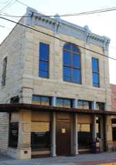 | Farmersville Masonic Lodge No. 214, A.F. and A.M | 0.2 miles | 2005 |
| Plano Downtown Historic District | 3.6 miles | 2017 |
| National Archives record | The nomination case file for reference 83003131 in Record Group 79. |
| Collin County | All 69 listed properties in this county. |