 Block
BlockFrom the record
One of 16 National Register listings published here for Nueces County · listed in 1983 · category: Building.
Sources: the case file at the National Archives · the National Register database, National Park Service
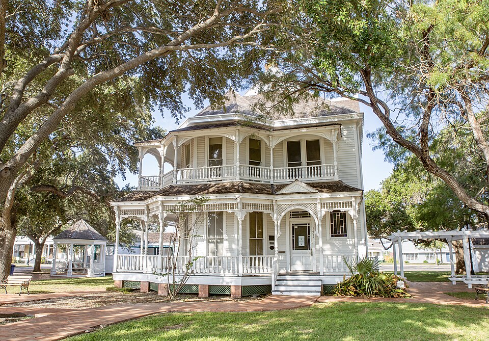
Listed on the National Register of Historic Places in 1983.
One of 16 National Register listings published here for Nueces County · listed in 1983 · category: Building.
Sources: the case file at the National Archives · the National Register database, National Park Service
Regional context, not property-specific evidence. The federal wildfire occurrence database lists 5 fires within 5 miles of Charlotte Sidbury House between 2008 and 2017, burning about 204 acres in total. None started naturally. None was recorded as arson. Distance is straight-line from the map coordinates, so a fire counted here may appear on a neighbouring settlement's page as well.
| Reported cause | Fires |
|---|---|
| Debris and open burning | 2 |
| Misuse of fire by a minor | 1 |
| Power generation/transmission/distribution | 1 |
| Equipment and vehicle use | 1 |
The most recent of them, most recent first, with the day each was reported and the service that recorded it.
| Date | Cause | Size | Reported by | Name on the report |
|---|---|---|---|---|
| 18 July 2010 | Misuse of fire by a minor | 1.0 acres | Texas A & M Forest Service | 2146 SAVOY |
| 2 April 2009 | Power generation/transmission/distribution | 100 acres | Texas A & M Forest Service | 5217 SUNBELT |
| 27 February 2008 | Equipment and vehicle use | 100 acres | Texas A & M Forest Service | not named |
| 12 February 2017 | Debris and open burning | 2.0 acres | Texas A & M Forest Service | 17-022 |
| 18 October 2017 | Debris and open burning | 1.0 acres | Texas A & M Forest Service | BRUSH FIRE |
Regional context, not property-specific evidence. The federal mineral resources record lists 10 workings within 5 miles of Charlotte Sidbury House: 7 producers, 3 plants. All of them still produce. What was taken out: Sulfur, Chromium, Barium-Barite, Silica. Distance is straight-line from the map coordinates, so a quarry counted here may appear on a neighbouring settlement's page as well.
| Where | Site | Commodity | Status | Recorded |
|---|---|---|---|---|
| (Facility) Corpus Christi Zinc Refinery | Zinc, Cadmium | Plant | ||
| Centex Corp Clay Pit | Clay | Producer | ||
| Corpus Christi Grinding Plant | Cement Rock | Producer | ||
| Corpus Christi Texas Plant | Chromium | Producer | ||
| Corpus Cristi Mill | Barium-Barite | Producer | ||
| Hitox Plant | Titanium | Producer | ||
| P P G Industries Inc Operation | Silica | Producer | ||
| (Facility) Champlin's Corpus Christi Refinery | Sulfur | Plant | ||
| (Facility) Valero Corpus Christi Refinery | Sulfur | Plant | ||
| Coastal Sulfur Plant | Sulfur | Producer |
Regional context, not property-specific evidence. The National Weather Service names Corpus Christi, the town this property stands in, in 142 storm reports between 1993 and 2025: 63 flash flood, 34 hail, 30 thunderstorm wind, 4 waterspout. The reports record 4 injuries. Each account below is quoted exactly as the forecast office filed it, from the NOAA Storm Events Database, and each date opens the federal record of that event.
| When | Event | Place named | Harm | What the report says |
|---|---|---|---|---|
| July 2004 | Lightning | Corpus Christi | 3 hurt | Lightning nearly struck three golfers at the Corpus Christi County Club. All three were knocked to the ground and one blacked out. Injuries were very minor. |
| March 2000 | Flash Flood | Corpus Christi | 1 hurt, $100,000 | 6.55 inches of rainfall was recorded at the downtown storm water pump station. The city storm drainage pumps were unable to remove the excess runoff caused by heavy rainfall. Several streets were flooded, with some water damage to downtown businesses. Emergency crews rescued several people from cars stalled in the flood waters. One man was injured when he was pinned in a storm drain by flowing water. |
| June 2010 | Thunderstorm Wind | Corpus Christi | $1,000,000 | Several hundred large trees and tree limbs snapped throughout the city of Corpus Christi in addition to many power poles. Minor damage was reported to some homes were trees came down on them. Some business signs were blown out. Over 31,000 customers were left without power in Nueces County alone. Debris and brush cleanup by the city went on for weeks after the storm. |
| May 2015 | Tornado (EF1) | Corpus Christi | $750,000 | The tornado touched down near Cunningham Middle School just north of Golihar Road where trees were snapped and uprooted. A residence just north of the school at the corner of Hudson and Stafford Streets sustained moderate roof damage and a had a fence blown down. The tornado continued to the northeast crossing Horne Road and parallel to Sarita Street. Dozens of trees were snapped and uprooted with many falling on homes or vehicles. Several residences suffered roof and siding damage in this area. Further northeast, the tornado hit a grocery store on Tarlton Street destroying a sign and blowing several windows out. Tree and minor roof damaged was observed northeast of this area as the tornado crossed Baldwin and Morgan Avenues. The last evidence of the tornado was at 16th Street and Crosstown Expressway where a nursery sustained damage and a baseball dugout was destroyed. Maximum winds were estimated around 90 mph. |
| April 2015 | Thunderstorm Wind | Corpus Christi | $500,000 | Widespread tree damage occurred across the city of Corpus Christi. Damage started southwest of the downtown Bayfront and continued southeast across the area around Ray High School to south of Oso Beach Municipal Golf Course and then to Flour Bluff. This caused widespread power outages due to downed power lines also. |
| June 2006 | Flash Flood | Corpus Christi | $300,000 | Nearly 12 inches of rain fell across west-central Corpus Christi during the late night hours of May 31st and the early morning hours of June 1st. The flooding began at roughly 2345 CST on May 31st and continued through roughly 0615 CST on June 1st. The Corpus Christi International Airport recorded a 24 hour rainfall total of 11.47", establishing a new all time 24 hour precipitation record. Numerous city streets became flooded, along with a seven mile stretch of Highway 44 (from the Corpus Christi International Airport to F.M. 1694), North Padre Island Drive (Highway 358) and a section of Interstate 37 (near Corn Products Road). Numerous cars became stranded in high water. There was one indirect fatality when a 51 year old woman abandoned her flooded vehicle and began walking on the shoulder of Highway 358. The woman was struck and killed by a van exiting Highway 358. Many high water vehicle rescues were performed by the Corpus Christi Fire Department, including rescues on I-37, Highway 44 and Highway 358. Several people were also evacuated from their homes, which included homes near Manchester Avenue and I-37.Other areas in the city that flooded included, but were not limited to, homes near Clarkwood Road and Highway 44, homes in the Las Colonias subdivsion near Greenwood Avenue and Saratoga, sections of Old Brownsville Road near Saratoga and several roads and neighborhood between Highway 44 and I-37Dollar estimates on the damages are rough, conservative estimates and are likely underestimated. See episode narrative below for further details on the event.The flash flooding also complicated efforts to contain an oil spill, intially caused by lightning, at the Valero Refinery. More info on this oil spill can be found below, in the lightning event. |
| June 2017 | Flash Flood | Corpus Christi | $250,000 | Flood waters made multiple roads impassable in the downtown area of Corpus Christi. Numerous vehicles were stranded in the high water. |
| October 2021 | Flash Flood | Corpus Christi | $100,000 | Severe flooding occurred on North Padre Island Drive under Leopard Street and along Interstate 37. Several vehicles were disabled or stranded due to driving through high water. |
| June 2007 | Thunderstorm Wind | Corpus Christi | $50,000 | The bow echo resulted in wind damage across portions of Corpus Christi and Port Aransas. Many tree limbs were snapped across Corpus Christi and several trees were completely uprooted. Power lines were downed by falling tree limbs in many areas, and a power pole was completely snapped in half by the winds in Flour Bluff. More than 10,000 customers lost power, including many businesses that were forced to temporarily close. A boat was also flipped off the trailer it was on at North Beach.| |
| May 1993 | Thunderstorm Wind | Corpus Christi | $50,000 | ,Dime-size hail was reported at the National Weather Service Office and at the Navel Air Station along with wind gusts to 58 MPH. The Sheriff's Office reported power lines down south of the International Airport. TV-Channel 6 reported wind gusts between 55 and 60 MPH in Robstown. |
| May 1995 | Thunderstorm Wind | Corpus Christi | $30,000 | A local radio station KCCT 1190 AM reported 52 kt winds with damage to large sections of the station's roof. The radio transmitter was also damaged with the station reported off-the-air for three days with a total damage estimated at $30 thousand. |
| July 2015 | Thunderstorm Wind | Corpus Christi | $25,000 | A large carport was blown on to power lines. Power poles were blown down near the intersection of Staples and Ayers Streets. |
| June 2013 | Thunderstorm Wind | Corpus Christi | $10,000 | Trees were blown down and blocked Santa Fe Street in Corpus Christi. |
| September 2013 | Flash Flood | Corpus Christi | $10,000 | Flooding was observed on many city streets in the central portion of Corpus Christi. Two to three feet of water was reported over the roadway at McArdle Road near La Palmera Mall, leading to stalled vehicles. Water was over the road at several intersections from Port Avenue and Crosstown Expressway to Alameda and Robert Streets. |
| March 2000 | Thunderstorm Wind | Corpus Christi | $10,000 | Roof damage to drive-in restaurant. |
| April 2013 | Flash Flood | Corpus Christi | $5,000 | Local television station reported Morgan and Baldwin Streets near 19th Street and Crosstown Expressway were flooded. |
| April 1994 | Thunderstorm Wind | Corpus Christi | $5,000 | Corpus Christi International Airport recorded a peak wind gust to 58 knots. |
| June 2017 | Thunderstorm Wind | Corpus Christi | $1,000 | Public submitted images of a large tree blown down next to a house near Santa Fe Street. |
| September 2025 | Flash Flood | Corpus Christi | - | Social media post on Facebook shows photos of several inches of standing water. Photos of cars driving through the water are also included. Report came from the intersection of Baldwin Blvd, Virginia Ave, and Morgan Avenue. |
| September 2025 | Flash Flood | Corpus Christi | - | Facebook post of trash cans floating in a few inches of standing water at the intersection of Dolores St and Highland St. |
| September 2025 | Flash Flood | Corpus Christi | - | Social media video from Facebook showed a Chevrolet pickup truck driving through several inches of standing water at the intersection of Baldwin Blvd and Osage St. |
| May 2023 | Flash Flood | Corpus Christi | - | Corpus Christi Emergency Manager reported the 4500 block of Baldwin Boulevard was flooded. |
| August 2023 | Flash Flood | Corpus Christi | - | The northwest loop exit from Interstate 37 to Highway 286 flooded. |
| August 2022 | Flash Flood | Corpus Christi | - | The northwest loop ramp to southbound State Highway 286 was closed due to flooding. |
| August 2022 | Flash Flood | Corpus Christi | - | The Nueces Bay Boulevard exit on Martin Luther King Drive was closed due to flooding. |
| August 2022 | Flash Flood | Corpus Christi | - | Emergency manager reported street flooding at Tarlton Street and Blanc Courts near downtown Corpus Christi. |
| April 2021 | Flash Flood | Corpus Christi | - | Streets were flooded around downtown Corpus Christi. |
| May 2021 | Flash Flood | Corpus Christi | - | Ayers Street and Tarlton Street flooded due to heavy rain. |
| May 2021 | Flash Flood | Corpus Christi | - | Baldwin and Osage Streets flooded. |
| May 2021 | Flash Flood | Corpus Christi | - | Several roads flooded and closed in Corpus Christi, including: Interstate 37 at Carbon Plant, State Highway 286 at Holly Road, Rodd Field Road from South Padre Island Drive to Holly Road. |
| September 2021 | Flood | Corpus Christi | - | Construction road ramps from Interstate 37 and Highway 286 were flooded and not passable. Law enforcement reported multiple road closures in this area around downtown Corpus Christi. |
| September 2021 | Flood | Corpus Christi | - | Road closure on Tarlton Street between Churchill Drive and Ayers Street occurred due to flood waters. |
| October 2021 | Flash Flood | Corpus Christi | - | Flooding was reported near the downtown area of Corpus Christi. Flooding was reported on Crosstown Expressway from downtown to near Tarlton Street. Flooding also occurred near Interstate 37 near North Staples Street. |
| October 2021 | Flash Flood | Corpus Christi | - | Twitter video showed flood waters up to bumpers of cars near Louis Lynch Drive and Interstate 37. |
| October 2021 | Flash Flood | Corpus Christi | - | High water was over the road at Buford and 3rd Streets in downtown Corpus Christi. |
| May 2020 | Flash Flood | Corpus Christi | - | Flooding of roads occurred near the intersection of Staples Street and Texas Avenue in Corpus Christi. |
| May 2020 | Flash Flood | Corpus Christi | - | Roads were closed due to flooding near the Leopard Street and Crosstown Expressway. |
| September 2018 | Flood | Corpus Christi | - | Water was over the road at Buford Street and 3rd Street intersection in Corpus Christi. |
| September 2018 | Flood | Corpus Christi | - | Multiple streets were affected by minor flooding in Corpus Christi to south of town. Water affected Weber Road, Highway 286 south to Farm to Market Road 70 and County Roads 28 and 57. |
| June 2017 | Flash Flood | Corpus Christi | - | Water flooded Alameda and Staples Streets around the Six Points area. |
| March 2017 | Flash Flood | Corpus Christi | - | High water rescue occurred with no injuries reported. |
| March 2017 | Flash Flood | Corpus Christi | - | Numerous reports of roads flooded around the downtown area of Corpus Christi. |
| June 2017 | Thunderstorm Wind | Corpus Christi | - | Corpus Christi Police Department reported 60 mph winds on Crosstown Expressway near Baldwin Boulevard. Nickel sized hail was also reported. |
| March 2016 | Flash Flood | Corpus Christi | - | Corpus Christi Police reported flooding at the intersections of Highway 286 and Coleman Avenue, Staples Street at Six Points, Staples Street and Furman Avenue, and Interstate 37 northbound at Mesquite Street. |
| April 2015 | Flash Flood | Corpus Christi | - | Water flooded the roadways in several parts of Corpus Christi. Flooding was reported near Leopard and Peabody, along the South Padre Island Drive frontage road, and near the intersection of Staples and Lipe Streets. |
| May 2015 | Flash Flood | Corpus Christi | - | Brawner Parkway from Kostoryz Road to Devon Drive was flooded. |
| September 2014 | Flash Flood | Corpus Christi | - | High water made roads impassable on Morgan Street between Alameda Street and 15th Street in Corpus Christi. |
| October 2014 | Flash Flood | Corpus Christi | - | Public reported flood waters were deep enough to prevent fire trucks from reaching the downtown area at Crosstown Expressway and Leopard Street. |
| July 2007 | Flash Flood | Corpus Christi | - | Between 1 and 3 inches of rain feel quickly over already saturated ground in southwest Corpus Christi. Many frontage roads near the Crosstown Expressway and S.P.I.D. interchange were under 1 to 2 feet of water and impassable. Weber road out near Hwy 286 was also flooded and impassable. Frontage roads at S.P.I.D. and Kostoryz were under several feet of water and impassable.| |
| April 2007 | Hail | Corpus Christi | - | Pea to nickle size hail reported thoughout portions of south-central and the downtown areas of Corpus Christi.| |
| July 2007 | Flash Flood | Corpus Christi | - | Between 1 and 3 inches of heavy rain fell over portions of Corpus Christi. Hardest hit were several city streets in and around Mcardle at Nile as well as the Pharaoh Valley subdivision, were flash flooding occurred. NAS Corpus Christi was forced to close incoming and outgoing gates at one point when floodwaters caused several vehicles to stall. The Crosstown Expressway underpass near Mexico Street and Leopard was also flooded and barricaded. |
| July 2007 | Flash Flood | Corpus Christi | - | One to two inches of rain fell during the evening, over already saturated grounds from morning rainfall. A few city streets in central and northern Corpus Christi were flooded and impassable due flooding. |
| July 2007 | Flash Flood | Corpus Christi | - | Between 3 and 5 inches of heavy rainfall resulted in several city streets flooded and impassable throughout Corpus Christi. In addition, Interstate 37 at Corn Products Road was flooded with several feet of water. |
| May 2006 | Flash Flood | Corpus Christi | - | Nearly 12 inches of rain fell across west-central Corpus Christi during the late night hours of May 31st and the early morning hours of June 1st. The Corpus Christi International Airport recorded a 24 hour rainfall total of 11.47", establishing a new all time 24 hour precipitation record. Numerous city streets became flooded, along with portions of Highway 44, North Padre Island Drive (Highway 358) and Interstate 37. Numerous cars became stranded in high water. There was one indirect fatality when a 51 year old woman abandoned her flooded vehicle and began walking on the shoulder of Highway 358. The woman was struck and killed by a van exiting Highway 358. The flooding began at roughly 2345 CST on May 31st and continued through roughly 0615 CST on June 1st. Please reference June Storm Data for damage estimates and an episode narrative. |
| June 2006 | Lightning | Corpus Christi | - | Lightning struck a waste oil tank at the Valero Bill Greehey Refinery between 100 and 130 AM CDT. The lightning strike resulted in a fire as well as an oil spill. The fire destroyed the large oil storage tank and part of the pipe rack behind it, used to offload oil from ships. The oil spilled into a containment dike. The heavy rainfall, as well as well as water used to put out the fire, caused the oil to spill over the containment dike and into the Corpus Christi Ship Channel. Valero estimated roughly 63,000 gallons of an oil water mix (roughly 1500 barrels) spilled into the ship channel. The Corpus Christi Ship Channel was closed for several days while the oil was cleaned up.Dollar estimates on the damage that occurred to the tank and pipe rack, as well as the cost of the oil and cleanup, were unknown at the time of this publication.See episode narrative below for further details on the event. |
| July 2006 | Flash Flood | Corpus Christi | - | Heavy rainfall fell across the south side of Corpus Christi leading to all S.P.I.D. (Hwy 358) underpasses from Staples St. to Flour Bluff flooded, including Nile and Rodd Field which caused backups on Hwy 358. Several cars became stranded in the high water. High water on Airline, from Hwy 358 to Gollihar, also caused several cars to stall in the high water. High water and impassable streets were also reported in neighborhoods near Century Theater on S.P.I.D. There were several other reports of minor flooding of secondary streets throughout the south side of Corpus Christi.NWS radar estimated 1 to 3 inches of rain fell across central and south Corpus Christi, with isolated amounts of 3 to 4 inches across the south side. |
| March 2005 | Hail | Corpus Christi | - | Reported in downtown Corpus Christi by Fire Dept. |
| March 2005 | Thunderstorm Wind | Corpus Christi | - | Trained spotters and off-duty NWS employee reported pea to marble sized hail and estimated 50 kt winds on south side of Corpus Christi. (Lipes at Clubgate and Airline at Yorktown) |
| May 2005 | Hail | Corpus Christi | - | Quarter size hail reported by NWS employee at Weber and Saratoga. |
| May 2005 | Hail | Corpus Christi | - | Reported by NWS employee at Weber and Saratoga. |
No historic map-sheet match is published for this property yet. That does not mean no map exists. This record needs a coordinate-quality review before it can be joined to a sheet boundary. Browse the county's mapped places while that work is pending.
Other National Register properties close enough to walk or drive between, ordered by distance from this one. Both positions come from the same geocoding pass that matched these properties to their map sheets.
| Photograph | Property | Distance | Listed |
|---|---|---|---|
 | Simon Gugenheim House | under 500 feet | 1983 |
 | S. Julius Lichtenstein House | 0.2 miles | 1983 |
 | Nueces County Courthouse | 0.3 miles | 1976 |
| Old Bayview Cemetery | 0.4 miles | 2020 | |
 | Sherman Building | 0.6 miles | 2010 |
| Ritz Theatre | 0.6 miles | 2024 |
| National Archives record | The nomination case file for reference 83003157 in Record Group 79. |
| Nueces County | All 16 listed properties in this county. |