 Block
BlockFrom the record
One of 316 National Register listings published here for Harris County · listed in 1996 · category: Building.
Sources: the case file at the National Archives · the National Register database, National Park Service
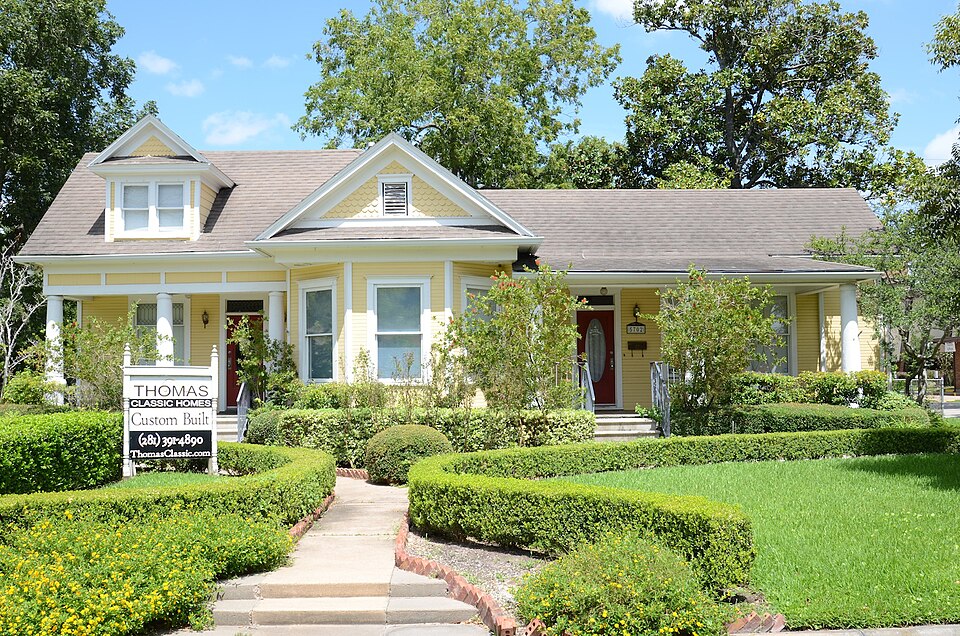
Listed on the National Register of Historic Places in 1996.
One of 316 National Register listings published here for Harris County · listed in 1996 · category: Building.
Sources: the case file at the National Archives · the National Register database, National Park Service
Regional context, not property-specific evidence. The federal wildfire occurrence database lists 6 fires within 5 miles of Dr. James M. and Dove Stewart House between 2003 and 2019, burning about 7 acres in total. None started naturally. None was recorded as arson. Distance is straight-line from the map coordinates, so a fire counted here may appear on a neighbouring settlement's page as well.
| Reported cause | Fires |
|---|---|
| Missing data/not specified/undetermined | 3 |
| Debris and open burning | 3 |
The most recent of them, most recent first, with the day each was reported and the service that recorded it.
| Date | Cause | Size | Reported by | Name on the report |
|---|---|---|---|---|
| 13 August 2019 | Missing data/not specified/undetermined | 1.0 acres | Texas A & M Forest Service | KATY FREEWAY |
| 27 July 2003 | Debris and open burning | 2.0 acres | Texas A & M Forest Service | CONROE - 61 |
| 13 April 2013 | Debris and open burning | 1.0 acres | Texas A & M Forest Service | GRASS FIRE |
| 11 April 2013 | Debris and open burning | 1.0 acres | Texas A & M Forest Service | ILLEGAL BURN |
| 1 January 2008 | Missing data/not specified/undetermined | 1.0 acres | Texas A & M Forest Service | not named |
| 1 January 2008 | Missing data/not specified/undetermined | 1.0 acres | Texas A & M Forest Service | not named |
Regional context, not property-specific evidence. The National Weather Service names Katy, the town this property stands in, in 52 storm reports between 1993 and 2024: 24 hail, 15 thunderstorm wind, 6 funnel cloud, 4 flash flood. The reports record 1 injury. Each account below is quoted exactly as the forecast office filed it, from the NOAA Storm Events Database, and each date opens the federal record of that event.
| When | Event | Place named | Harm | What the report says |
|---|---|---|---|---|
| November 2000 | Tornado (F1) | Katy | 1 hurt, $250,000 | Tornado near intersection of Grand Parkway and Colonial Parkway. Tornado damaged portion of roof on Albertson's warehouse then flipped over two office trailers. Several homes damaged in Williamsburg Hamlet subdivision with roof damage to three homes, windows blown out, and major fence damage. One home completely destroyed. One man was injured in a tractor-trailer that flipped over on the Grand Parkway. |
| May 2024 | Thunderstorm Wind | Katy | $70,000,000 | Trained spotters reported trees downed in Katy by strong thunderstorm winds as a derecho moved through the area. Damage dollar totals include all of Harris County and City of Houston for this event. |
| May 1999 | Thunderstorm Wind | Katy | $100,000 | Power poles down along Clay Rd., roof damage at Taylor H.S., and traffic signals damaged along Mason Rd. and Fry Rd. |
| August 2022 | Lightning | Katy | $50,000 | A lightning strike caused a residential fire on Murano Garden Court. |
| April 2004 | Hail | Katy | $50,000 | Golfball-size hail in the Bear Creek subdivision at intersection of Hwy 6 and Clay road (Key Map 448E). |
| February 1998 | Thunderstorm Wind | Katy | $30,000 | Widespread trees down and minor structural damage reported from a bow echo moving across western Harris County. Wind measured at 60 mph at I-10 & Beltway 8. |
| August 1998 | Thunderstorm Wind | Katy | $25,000 | Trees down in Katy (some on roofs). Katy High School sustained $10,000 in damage. |
| April 2001 | Hail | Katy | $25,000 | no account filed |
| April 2000 | Hail | Katy | $25,000 | no account filed |
| May 2019 | Flash Flood | Katy | $20,000 | Many west and northwestern Houston roadways became impassable due to flooding. There were many stranded or flooded vehicles near the Katy Freeway with reports of some high water rescues from vehicles. |
| April 2004 | Hail | Katy | $15,000 | Penny-sized hail reported. |
| April 2004 | Hail | Katy | $15,000 | Penny-sized hail reported. |
| November 2000 | Thunderstorm Wind | Katy | $15,000 | Power lines down. |
| April 2001 | Hail | Katy | $15,000 | no account filed |
| June 2020 | Flash Flood | Katy | $10,100 | There was widespread street flooding between the Jersey Village area and the Katy area. Several roads were flooded. There were multiple reports of stalled cars. |
| March 2000 | Hail | Katy | $10,000 | no account filed |
| April 2003 | Hail | Katy | $6,000 | no account filed |
| August 2012 | Thunderstorm Wind | Katy | $5,000 | Large tree limbs stripped off trees near the intersection of Katy Hockley Road and Longenbaugh Road. |
| February 2003 | Hail | Katy | $5,000 | 3/4 inch hail. |
| October 1998 | Thunderstorm Wind | Katy | $5,000 | Trees and powerlines blown down. |
| July 1998 | Thunderstorm Wind | Katy | $5,000 | Trees blown down at key map 485G. |
| June 1997 | Thunderstorm Wind | Katy | $5,000 | Large tree uprooted on Fry Rd. |
| February 1993 | Hail | Katy | $5,000 | A report was received from Houston Emergency Management of 1-inch hail in Katy. |
| April 1997 | Hail | Katy | $5,000 | no account filed |
| June 1996 | Thunderstorm Wind | Katy | $5,000 | no account filed |
| August 1996 | Hail | Katy | $5,000 | no account filed |
| December 2006 | Hail | Katy | $4,000 | Nickel size hail. |
| March 2007 | Hail | Katy | $3,000 | Nickel size hail at the Fry Road and Sun Glenn Blvd intersection. |
| August 1998 | Thunderstorm Wind | Katy | $3,000 | Large limbs blown down along HWY 90. |
| February 1998 | Hail | Katy | $3,000 | no account filed |
| May 1995 | Hail | Katy | $1,000 | Amateur radio operators reported 3/4 inch hail in Katy at the intersection of Highways 6 and 290. |
| May 1995 | Hail | Katy | $1,000 | Amateur radio operators reported three-quarters inch hail in Katy at the intersection of Highways 6 and 290. |
| May 1993 | Thunderstorm Wind | Katy | $500 | The HAMS spotter network reported winds of 60 mph in Katy. |
| March 2024 | Hail | Katy | - | Nickel sized hail was observed. |
| December 2024 | Funnel Cloud | Katy | - | A member of the public reported a funnel cloud in western Harris county. |
| April 2023 | Hail | Katy | - | There was quarter sized hail in the Katy area. |
| August 2022 | Thunderstorm Wind | Katy | - | Large trees were downed near East Avenue in Katy. |
| August 2022 | Thunderstorm Wind | Katy | - | Some trees were knocked down. |
| October 2021 | Flash Flood | Katy | - | Peek Rd was closed between Stockdick School Rd and Beckendorf Rd due to floodwaters. |
| April 2020 | Hail | Katy | - | Ping pong ball sized hail was reported. |
| April 2020 | Hail | Katy | - | Quarter sized hail was reported near Legacy Stadium. |
| April 2020 | Hail | Katy | - | Golf ball sized hail was reported at the Waller Harris County ESD 200 Fire And EMS Station. |
| April 2015 | Thunderstorm Wind | Katy | - | This wind gust was at the intersection of Franz Road and Highway 99. |
| October 2015 | Flash Flood | Katy | - | There was widespread flooding around the city of Houston. There were numerous reports of flooded and impassable roadways with submerged vehicles. Vehicles were submerged near Fondren Road and the Highway 59 southwest freeway as well as in the Galleria area. The Katy exit ramp to the north freeway was closed due to high water. Interstate 45 at North Shepherd had two feet of water flowing across all lanes. Highway 59 at the 610 Loop interchange was closed due to high water. There was also high water reported over Clay Road at North Eldridge in Bear Creek Pioneers Park that was blocking traffic. Sections of Memorial Drive near Bagby Street were closed due to high flood waters. All entrances to downtown Houston off of Interstate 45 were closed due to high water over the roadways. Eastbound Interstate 10 was closed due to high water near White Oak Bayou. |
| July 2014 | Heavy Rain | Katy | - | Heavy rain (an estimated three inches) from a slow moving thunderstorm produced localized street flooding. There was up to two feet of water over the road along Avenue D in Katy. |
| August 2007 | Funnel Cloud | Katy | - | Funnel cloud sighted in the Katy area. |
| April 2004 | Funnel Cloud | Katy | - | Funnel cloud sighted on Mason Road, north of I-10. |
| September 2003 | Funnel Cloud | Katy | - | Funnel cloud reported near Katy. |
| August 2003 | Funnel Cloud | Katy | - | Descending funnel cloud observed. |
| May 2007 | Hail | Katy | - | no account filed |
| September 2000 | Funnel Cloud | Katy | - | no account filed |
| March 1995 | Hail | Katy | - | no account filed |
No historic map-sheet match is published for this property yet. That does not mean no map exists. This record needs a coordinate-quality review before it can be joined to a sheet boundary. Browse the county's mapped places while that work is pending.
| National Archives record | The nomination case file for reference 96000067 in Record Group 79. |
| Harris County | All 316 listed properties in this county. |