 Block
From the record
7 National Register listings published here, 1 of them a National Historic Landmark.
Sources: the National Register database, National Park Service
104 topographic sheets cover 50 settlements here, and 7 properties are on the National Register of Historic Places.
7 National Register listings published here, 1 of them a National Historic Landmark.
Sources: the National Register database, National Park Service
Every property in this county listed on the National Register of Historic Places, with the year it was listed and the federal nomination document.
| Photograph | Property | Type | Listed | Reference |
|---|---|---|---|---|
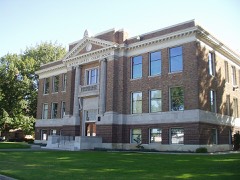 | Benton County Courthouse | building | 1976 | 76001869 |
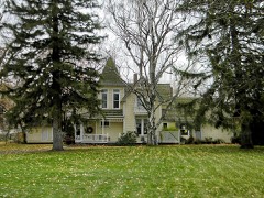 | J. W. Carey House | building | 1989 | 89002096 |
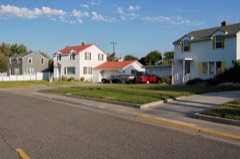 | Gold Coast Historic District | district | 2005 | 04000315 |
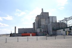 | Hanford B Reactor | structure | 1992 | 92000245 |
| Kennewick Fruit & Produce Company Building | building | 2025 | 100011980 | |
| Post Office and Federal Office Building | building | 2024 | 100010893 | |
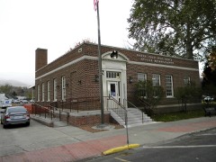 | US Post Office-Prosser Main | building | 1991 | 91000653 |
Every wildfire the federal occurrence database records inside this county: 253 of them, burning about 304,070 acres. 41 started naturally and 23 were recorded as arson. Each settlement page carries the fires within five miles of it.
| Reported cause | Fires |
|---|---|
| Missing data/not specified/undetermined | 83 |
| Equipment and vehicle use | 42 |
| Natural | 41 |
| Arson/incendiarism | 23 |
| Debris and open burning | 19 |
| Railroad operations and maintenance | 16 |
| Recreation and ceremony | 10 |
| Firearms and explosives use | 10 |
| Fireworks | 3 |
| Power generation/transmission/distribution | 2 |
| Smoking | 2 |
| Misuse of fire by a minor | 2 |
The five largest, by the area the report gives. None of them was recorded as arson.
| Date | Cause | Size | Reported by | Name on the report |
|---|---|---|---|---|
| 27 June 2000 | Equipment and vehicle use | 163,884 acres | Hanford Reach National Monument | 24 COMMAND |
| 18 July 2019 | Recreation and ceremony | 41,748 acres | Hanford Reach National Monument | COLD CREEK |
| 28 July 1998 | Natural | 6,500 acres | Hanford Reach National Monument | ELKMEADOW |
| 29 July 2007 | Missing data/not specified/undetermined | 6,000 acres | Washington State Fire Marshal's Office | LES BLAIR |
| 26 August 1997 | Debris and open burning | 5,500 acres | Spokane District | OLYMPIA ST |
| 22 June 2005 | Missing data/not specified/undetermined | 5,000 acres | Oregon Department of Forestry Salem Headquarters | JUNIPER CANYON |
| 13 August 2007 | Missing data/not specified/undetermined | 4,704 acres | Hanford Reach National Monument | MILEPOST 17 |
| 11 August 2018 | Missing data/not specified/undetermined | 4,700 acres | Washington State Fire Marshal's Office | BOFFER |
Every settlement page carries the fires within five miles of it - see the settlement index below.
The NOAA Storm Events Database holds 88 reports for this county, causing no deaths, no injuries and about $576,500 in recorded property damage. Each settlement page carries the reports that name it.
| Kind of event | Reports |
|---|---|
| Thunderstorm Wind | 52 |
| Hail | 14 |
| Flood | 6 |
| Tornado | 5 |
| Funnel Cloud | 5 |
| Wildfire | 3 |
| Flash Flood | 2 |
| Dust Devil | 1 |
The most serious of them, by death, then injury, then recorded damage. The accounts are quoted exactly as the forecast office filed them.
| When | Event | Place named | Harm | What the report says |
|---|---|---|---|---|
| January 2009 | Flood | Prosser | $453,000 | The Kiona river gage rose to 2.55 feet above flood stage. |
| January 2011 | Flood | North Prosser | $60,000 | In Benton County, there was minor flooding at the RV park along the river at Benton City and through the rural areas of West Richland. At the higher levels, some water from the river flows through a low bank area and moves overland through a rural subdivision and then rejoins the main river channel. Homes are built up so water does not enter them, but there was 60,000 dollars in damages to roads and outbuildings. |
| May 2016 | Tornado (EF0) | Kennewick Vista Arpt | $20,000 | We received a cell phone video captured from the general public that showed swirling motion at the surface. |
| July 2002 | Thunderstorm Wind | Kennewick | $20,000 | Ham radio operator reported trees blown into cars and homes. |
| August 2000 | Thunderstorm Wind | Kennewick | $20,000 | no account filed |
| June 2008 | Thunderstorm Wind | Kennewick | $2,000 | Carport roof was blown off. |
| June 2005 | Dust Devil | Richland | $1,000 | no account filed |
| May 2011 | Thunderstorm Wind | Prosser | $500 | Swirling winds from a thunderstorm gust front picked up lawn furniture which flew 500 feet, crashed into, and broke the back window of a car traveling along Byron Road west of Prosser. Cushions from the furniture traveled 300-400 yards across the Yakima River. The swirling winds were about 5 yards wide and traveled 250 yards to the north and then dissipated in trees north of the Yakima River. |
| March 2020 | Tornado (EF0) | North Richland | - | Multiple public videos of a weak landspout tornado on the north side of Richland, WA in an open area. No damage reported. |
| May 2020 | Thunderstorm Wind | Kennewick | - | Large tree blocking Kennewick Avenue near Newport Street. |
| May 2020 | Thunderstorm Wind | Prosser | - | Downed trees in Prosser. |
| May 2019 | Funnel Cloud | Benton City | - | A member of the public posted a picture of a funnel cloud to social media. Weak rotation verified by RADAR. |
| May 2019 | Hail | Benton City | - | A member of the public posted a video showing hail with a maximum size of 1 inch. |
| June 2019 | Flash Flood | Vista | - | Significant ponding was reported along West Forth and South Steptoe Street with water up to the bumpers on vehicles. |
| June 2019 | Thunderstorm Wind | Hanford | - | A mesonet station at the Hanford Site reported a gust to 62 mph near the Vernita Bridge. |
| May 2017 | Hail | Acton | - | Estimated 1.00 inch hail occurred at West Richland in Benton county. Report from social media via NBC Tri-Cities. |
| February 2017 | Flood | Badger | - | Mild temperatures February 9 -13 allowed an initial snow melt and heavy rain caused rapid melting and increased runoff across Benton county. This area had a snowpack of 5-10 inches on February 15, with much of it melted by February 21. Rain amounts of 0.50 to 0.75 were seen on February 16 and temperatures remained above freezing through February 22 with additional rain amounts of 0.50 to 1.00 inches on February 21-22. Numerous county roads had washouts, erosion, slides and undermining. |
| June 2017 | Thunderstorm Wind | Acton | - | A severe thunderstorms produced wind gusts of 62 to 68 mph occurred in and around West Richland in Benton county. |
| June 2017 | Flash Flood | Richland | - | Numerous intersections were flooded in Kennewick and Richland Washington, including Canal Drive and Volland Street, Gage Boulevard and Quinault Street. The Columbia Park Trail was closed from Hillwood to Rockwood due to flooding. Vista Field in Kennewick had 1.05 inches in one hour, with spotter reports of 0.64 inches to 0.94 inches in Richland and 0.70 inches to 1.01 inches in Kennewick. |
| August 2014 | Tornado (EF0) | North Prosser | - | Small tornado touched down in an open field with no damage reported. |
| August 2014 | Thunderstorm Wind | Badger | - | Public reported 3200 pound shed moved 20 feet with shingle damage. |
| August 2014 | Thunderstorm Wind | Prosser | - | Public reported a power outage due to strong winds. |
| September 2013 | Thunderstorm Wind | North Mc Nary | - | Multiple highway signs blown down along I-82 between Coffin Road and Oregon State Line. |
| September 2013 | Thunderstorm Wind | North Richland | - | Hanford Mesonet measured a 68 mph wind gust. |
| September 2013 | Thunderstorm Wind | Kennewick Vista Arpt | - | Mesonet at Vista Field measured a 58 mph wind gust. |
| September 2013 | Thunderstorm Wind | (Rld)Richland Arpt | - | Four inch tree limbs down, with blowing dust and restricting visibilities. |
| September 2013 | Thunderstorm Wind | Acton | - | A 77 mph wind gust measured by Hanford Mesonet. |
| September 2013 | Thunderstorm Wind | (Rld)Richland Arpt | - | Few power lines down and limbs on power lines. Power out until Friday morning for for some customers in the county. |
| September 2013 | Thunderstorm Wind | Kennewick Vista Arpt | - | Weather station measured a wind gust of 62 mph. Power went out at 715 pm. Wind blew down tree limbs 4 to 5 inches in diameter. |
| September 2013 | Thunderstorm Wind | North Mc Nary | - | Washington Ag Wx Net Station. |
| September 2013 | Thunderstorm Wind | North Mc Nary | - | Washington Ag Wx Net observation. |
| August 2013 | Thunderstorm Wind | Kennewick Vista Arpt | - | Tree limbs approx 4-7 inches in diameter down from thunderstorm wind gusts. |
| April 2012 | Funnel Cloud | Badger | - | The air traffic control tower at Pasco airport reported at funnel cloud about 15 miles southwest of the airport with little or no movement. |
| July 2012 | Hail | Finley | - | Radio operator reported hail damaged 3 vehicles and broke 2 house windows. |
| July 2012 | Thunderstorm Wind | Kennewick Vista Arpt | - | Wind caused the rain and hail to move sideways parallel to the ground. |
| May 2011 | Flood | Prosser | - | The Yakima River at Kiona crested at 15.5 feet on May 18th, which was 2.5 feet above flood stage. The flooding damaged several businesses in Prosser and farmland, roads, businesses, and residential areas from Prosser to Richland, including the Beach RV Park in Benton City and the West Richland Golf Course. |
| April 2011 | Flood | Gibbon | - | The river gage at Kiona crested at 1.3 feet above flood stage. |
| January 2009 | Flood | Yellepit | - | The Walla Walla River at Touchet crested at 1.87 feet above flood stage. |
| June 2008 | Thunderstorm Wind | Richland | - | Hanford Army Loop Road station reported 61 mph. |
| May 2006 | Thunderstorm Wind | Plymouth | - | Several irrigation pivots blown over. |
| May 2006 | Thunderstorm Wind | Finley | - | Winds damaged sheds, downed 4 poplar trees, and snapped a flag pole in half. |
| May 2006 | Thunderstorm Wind | Kennewick | - | Grain bin roof blown over and crushed. |
| May 2006 | Thunderstorm Wind | Finley | - | Numerous trees and powerlines down, some on houses and cars. |
| July 2006 | Thunderstorm Wind | Paterson | - | Thunderstorm wind gust ripped off large tree branches and blew nearly all apples onto the ground. A large aluminum tool box was blown 25 feet and an irrigation wheel line was moved. |
| April 2003 | Funnel Cloud | Prosser | - | A funnel cloud associated with a thunderstorm moved slowly northward. |
| July 2002 | Wildfire | Prosser | - | The Crosby Road Fire, sparked by lightning, consumed 2,000 acres and one structure. |
| June 2001 | Funnel Cloud | Hanford Works | - | A cold-core funnel cloud was reported underneath a convective shower over the Hanford Nuclear Reservation. |
| July 2001 | Thunderstorm Wind | Richland | - | A wind gust of 60 mph was measured at one of the observing sites on the Hanford Reservation. |
| July 2000 | Wildfire | Finley | - | Lightning from dry thunderstorms started two range fires near the town of Finley. One fire burned around 40 acres of fallow farmland near the intersection of Finley and Farm Roads south of Finley. The second fire started near Ayers Road and Yellepit pond. No structures were harmed by these two fires. |
| August 1997 | Wildfire | Berrian | - | A brush fire fueled by a powerful dust storm blackened the hills of south Kennewick. Over 5100 acres of sage brush were burnt and electricity to a local TV and radio tower was cut off by the fire. No homes were destroyed. |
| July 1995 | Thunderstorm Wind | not stated | - | In the Tri Cities street flooding and power outages accompanied the thunderstorm. Quarter-inch hail was also reported. |
| May 1994 | Hail | Hanford | - | A severe thunderstorm produced golf ball-sized hail and very heavy rain in the vicinity of Hanford. |
| May 2020 | Thunderstorm Wind | Plymouth | - | no account filed |
| May 2016 | Hail | Kennewick Vista Arpt | - | no account filed |
| August 2014 | Thunderstorm Wind | Hanford Works | - | no account filed |
| August 2013 | Thunderstorm Wind | Hanford | - | no account filed |
| August 2013 | Thunderstorm Wind | North Richland | - | no account filed |
| June 2013 | Hail | Prosser | - | no account filed |
| September 2013 | Thunderstorm Wind | Biggam | - | no account filed |
| August 2013 | Thunderstorm Wind | North Richland | - | no account filed |
The Survey's mineral resources record lists 87 workings inside this county. 8 still produce and 79 are closed or unrecorded. Each settlement page carries the workings within five miles of it.
| Commodity | Workings |
|---|---|
| Sand and Gravel, Construction | 42 |
| Stone, Crushed/Broken | 26 |
| Gold | 8 |
| Pumice | 4 |
| Clay | 3 |
| Perlite | 1 |
| Gemstone | 1 |
| Silver | 1 |
| Diatomite | 1 |
| Flagstone | 1 |
| Stone, Dimension | 1 |
The least common of them first, because a county's hundredth gravel pit says nothing its first ten did not.
| Where | Site | Commodity | Status | Recorded |
|---|---|---|---|---|
| Barrel Springs | Gemstone | Prospect | ||
| Gravel Pit | Stone, Dimension | Past Producer | ||
| Kiona | Diatomite | Occurrence | ||
| Prosser | Perlite | Occurrence | ||
| Prosser | Gold, Silver | Prospect | ||
| Prosser Quarry | Flagstone | Past Producer | ||
| Hanford | Clay | Past Producer | ||
| Kennewick | Clay | Past Producer | ||
| Prosser | Clay | Past Producer | ||
| Nine Canyon | Pumice | Occurrence | ||
| Prosser | Pumice | Occurrence | ||
| Rider Pit | Pumice | Past Producer | ||
| South Prosser | Pumice | Occurrence | ||
| Artesian Coulee Placer | Gold | Unknown | ||
| Berrian Island Placer | Gold | Occurrence | Placer | |
| Berrian Island Placer | Gold | Past Producer | ||
| Blalock Island Placer | Gold | Past Producer | ||
| Chinaman Bar Placer | Gold | Past Producer | 1939 | |
| Gone Busted Placer | Gold | Occurrence | Placer | |
| Gone Busted Placer | Gold | Past Producer | ||
| Borrow Pit | Stone, Crushed/Broken | Past Producer | ||
| Borrow Pit | Stone, Crushed/Broken | Past Producer | ||
| Crow Butte Pit | Stone, Crushed/Broken | Past Producer | ||
| D.O.E. Pit No. 1 | Sand and Gravel, Construction, Stone, Crushed/Broken | Producer | ||
| Farmers Field Pit | Stone, Crushed/Broken | Producer | ||
| Gravel Pit | Stone, Crushed/Broken | Past Producer | ||
| Gravel Pit | Stone, Crushed/Broken | Past Producer | ||
| Gravel Pit | Stone, Crushed/Broken | Past Producer | ||
| Highway 221 Quarry | Stone, Crushed/Broken | Past Producer | ||
| Johnson Pit | Stone, Crushed/Broken | Past Producer | ||
| Luth Quarry | Stone, Crushed/Broken | Past Producer | ||
| Marin Quarry | Stone, Crushed/Broken | Past Producer | ||
| Reils Quarry | Stone, Crushed/Broken | Past Producer | ||
| Rothrock Quarry | Stone, Crushed/Broken | Past Producer | ||
| Unnamed Quarry | Stone, Crushed/Broken | Past Producer | ||
| Unnamed Quarry | Stone, Crushed/Broken | Past Producer | ||
| Unnamed Quarry | Stone, Crushed/Broken | Past Producer | ||
| Unnamed Quarry | Stone, Crushed/Broken | Past Producer | ||
| Unnamed Quarry | Stone, Crushed/Broken | Past Producer | ||
| Unnamed Quarry | Stone, Crushed/Broken | Past Producer | ||
| Unnamed Quarry | Stone, Crushed/Broken | Past Producer | ||
| Unnamed Quarry | Stone, Crushed/Broken | Past Producer | ||
| Unnamed Quarry | Stone, Crushed/Broken | Past Producer | ||
| Unnamed Quarry | Stone, Crushed/Broken | Past Producer | ||
| Unnamed Quarry | Stone, Crushed/Broken | Past Producer | ||
| Unnamed Quarry S | Stone, Crushed/Broken | Past Producer | ||
| Acme Concrete Co | Sand and Gravel, Construction | Past Producer | ||
| Anderson Pit & Plant | Sand and Gravel, Construction | Past Producer | ||
| Benton City | Sand and Gravel, Construction | Occurrence | ||
| Cherry Lane Quarry | Sand and Gravel, Construction | Past Producer | ||
| Fallon Bridge Pit | Sand and Gravel, Construction | Past Producer | ||
| Fallon River Bar | Sand and Gravel, Construction | Occurrence | ||
| Finley Pit | Sand and Gravel, Construction | Past Producer | ||
| Gravel Pit | Sand and Gravel, Construction | Past Producer | ||
| Gravel Pit | Sand and Gravel, Construction | Past Producer | ||
| Hibbs Pit | Sand and Gravel, Construction | Past Producer | ||
| Hoit Pit | Sand and Gravel, Construction | Past Producer | ||
| Kennewick Pit | Sand and Gravel, Construction | Past Producer | ||
| Kiona | Sand and Gravel, Construction | Occurrence | ||
| Matheson Pit | Sand and Gravel, Construction | Producer | ||
| Matheson Pit | Sand and Gravel, Construction | Producer | ||
| Pf R-76 Pit | Sand and Gravel, Construction | Past Producer | ||
| Plymouth Pit | Sand and Gravel, Construction | Past Producer | ||
| Prairie Rock Pit | Sand and Gravel, Construction | Past Producer | ||
| Prosser Pit | Sand and Gravel, Construction | Past Producer | ||
| Putnam Pit | Sand and Gravel, Construction | Past Producer | ||
| Richland Pit | Sand and Gravel, Construction | Past Producer | ||
| Sanders and Young Pit | Sand and Gravel, Construction | Producer | ||
| Shelby Road Pit | Sand and Gravel, Construction | Past Producer | ||
| South Kiona | Sand and Gravel, Construction | Occurrence | ||
| State R-50 Quarry | Sand and Gravel, Construction | Past Producer | ||
| Unnamed Pit | Sand and Gravel, Construction | Past Producer | ||
| Unnamed Pit | Sand and Gravel, Construction | Past Producer | ||
| Unnamed Pit | Sand and Gravel, Construction | Past Producer | ||
| Unnamed Pit | Sand and Gravel, Construction | Producer | ||
| Unnamed Pit | Sand and Gravel, Construction | Past Producer | ||
| Unnamed Pit | Sand and Gravel, Construction | Producer | ||
| Unnamed Pit | Sand and Gravel, Construction | Past Producer | ||
| Unnamed Pit | Sand and Gravel, Construction | Past Producer | ||
| Unnamed Pit | Sand and Gravel, Construction | Past Producer | ||
| Unnamed Pit | Sand and Gravel, Construction | Past Producer | ||
| Unnamed Pit | Sand and Gravel, Construction | Past Producer | ||
| Unnamed Pit | Sand and Gravel, Construction | Producer | ||
| Unnamed Pit | Sand and Gravel, Construction | Past Producer | ||
| Unnamed Pit | Sand and Gravel, Construction | Past Producer | ||
| Unnamed Pit | Sand and Gravel, Construction | Past Producer | ||
| Unnamed Pit L | Sand and Gravel, Construction | Past Producer |
Named settlements recorded in the Geographic Names Information System, each with the topographic sheets covering it. Villages, hamlets and abandoned places alike. Each is shown with the nearest named watercourse or landform and the survey quadrangle it falls on.
Richland-Kennewick census division · 99320 · Near Scouten Canyon · Badger Mountain quadrangle
11 sheets, 1917 to 1965
South Benton census division · 99337 · Near Rush Canyon · Hat Rock quadrangle
14 sheets, 1908 to 1993
Hanford Site census division · 98944 · Locke Island quadrangle
12 sheets, 1924 to 1986
Richland-Kennewick census division · 99337 · Near Nine Canyon · Pasco quadrangle
12 sheets, 1917 to 1992
Hanford Site census division · 98944 · Wooded Island quadrangle
14 sheets, 1917 to 1992
Northwest Benton census division · 99350 · On Snipes Creek · Whitstran quadrangle
10 sheets, 1915 to 1965
Richland-Kennewick census division · 99352 · Near Bateman Island · Kennewick quadrangle
12 sheets, 1917 to 1992
Richland-Kennewick census division · 99336 · Near Zintel Canyon · Kennewick quadrangle
12 sheets, 1917 to 1992
Northwest Benton census division · 99350 · Prosser quadrangle
11 sheets, 1915 to 1965
No longer a settlement
South Benton census division · 99346 · Near Fourmile Canyon · Irrigon quadrangle
14 sheets, 1908 to 1993
No longer a settlement
South Benton census division · 99346 · Near Sillusi Butte · Umatilla quadrangle
15 sheets, 1908 to 1993
South Benton census division · 99350 · Near Monument Island · Paterson quadrangle
15 sheets, 1906 to 1993
Richland-Kennewick census division · 99336 · Near Clover Island · Pasco quadrangle
12 sheets, 1917 to 1992
Richland-Kennewick census division · 99352 · Near Bateman Island · Kennewick quadrangle
12 sheets, 1917 to 1992
Richland-Kennewick census division · 99352 · Near Bateman Island · Kennewick quadrangle
12 sheets, 1917 to 1992
Hanford Site census division · 98944 · Near Johnson Island · Wooded Island quadrangle
14 sheets, 1917 to 1992
Richland-Kennewick census division · 99337 · Near Zintel Canyon · Kennewick quadrangle
12 sheets, 1917 to 1992
Hanford Site census division · 98944 · Near Gable Butte · Gable Butte quadrangle
13 sheets, 1916 to 1986
Richland-Kennewick census division · 99336 · Kennewick quadrangle
12 sheets, 1917 to 1992
Richland-Kennewick census division · 99353 · Near Flat Top Hill · Richland quadrangle
13 sheets, 1917 to 1992
South Benton census division · 99345 · Near Canoe Ridge · Crow Butte quadrangle
17 sheets, 1906 to 1993
Northwest Benton census division · 99350 · On Spring Creek · Whitstran quadrangle
10 sheets, 1915 to 1965
The vanished settlements of Benton County: the places named above that are no longer on the map.