 Block
From the record
8 National Register listings published here.
Sources: the National Register database, National Park Service
56 topographic sheets cover 33 settlements here, and 8 properties are on the National Register of Historic Places.
8 National Register listings published here.
Sources: the National Register database, National Park Service
Every property in this county listed on the National Register of Historic Places, with the year it was listed and the federal nomination document.
| Photograph | Property | Type | Listed | Reference |
|---|---|---|---|---|
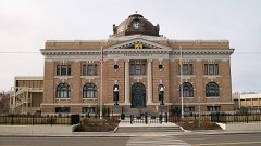 | Franklin County Courthouse | building | 1978 | 78002740 |
| Kurtzman Park Mini Station | building | 2022 | 100008491 | |
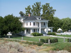 | James Moore House | building | 1979 | 79002532 |
| Morningstar Baptist Church | building | 2022 | 100008226 | |
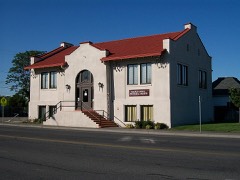 | Pasco Carnegie Library | building | 1982 | 82004212 |
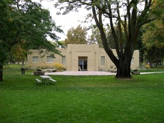 | Sacajawea State Park | district | 2007 | 07000364 |
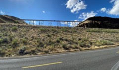 | Spokane, Portland and Seattle Railway Company-Box Canyon Viaduct | structure | 2018 | 100003280 |
Every wildfire the federal occurrence database records inside this county: 91 of them, burning about 95,408 acres. 18 started naturally and 3 were recorded as arson. Each settlement page carries the fires within five miles of it.
| Reported cause | Fires |
|---|---|
| Missing data/not specified/undetermined | 24 |
| Natural | 18 |
| Equipment and vehicle use | 15 |
| Recreation and ceremony | 14 |
| Debris and open burning | 9 |
| Firearms and explosives use | 4 |
| Arson/incendiarism | 3 |
| Power generation/transmission/distribution | 2 |
| Smoking | 2 |
The five largest, by the area the report gives. None of them was recorded as arson.
| Date | Cause | Size | Reported by | Name on the report |
|---|---|---|---|---|
| 7 September 2020 | Power generation/transmission/distribution | 22,000 acres | Spokane District | KAHLOTUS |
| 13 July 2007 | Natural | 17,946 acres | Hanford Reach National Monument | OVERLOOK |
| 7 October 2019 | Missing data/not specified/undetermined | 8,743 acres | Spokane District | MATSON |
| 29 June 1996 | Equipment and vehicle use | 8,480 acres | Spokane District | JUNIPER |
| 9 August 2005 | Debris and open burning | 6,851 acres | Hanford Reach National Monument | MCLANE |
| 22 August 2016 | Missing data/not specified/undetermined | 5,942 acres | Washington State Fire Marshal's Office | KAHLOTUS |
| 6 August 2003 | Natural | 5,200 acres | Spokane District | JUNIPER DU |
| 7 August 2016 | Missing data/not specified/undetermined | 4,033 acres | Washington State Fire Marshal's Office | PALOUSE FALLS |
Every settlement page carries the fires within five miles of it - see the settlement index below.
The NOAA Storm Events Database holds 45 reports for this county, causing 1 death, 4 injuries and about $3,817,000 in recorded property damage. Each settlement page carries the reports that name it.
| Kind of event | Reports |
|---|---|
| Thunderstorm Wind | 31 |
| Hail | 5 |
| Lightning | 3 |
| Tornado | 2 |
| Flood | 2 |
| Dust Devil | 1 |
| Funnel Cloud | 1 |
The most serious of them, by death, then injury, then recorded damage. The accounts are quoted exactly as the forecast office filed them.
| When | Event | Place named | Harm | What the report says |
|---|---|---|---|---|
| May 2020 | Thunderstorm Wind | Joso | 1 killed | A small recreational fishing vessel with 3 people on board capsized in rough seas created by a severe thunderstorms on the Snake River. 2 people (one male and one female) were able to make it safely to shore. One male was missing until Sunday morning (5/31) when he was located deceased by Search and Rescue. |
| May 2020 | Lightning | Pasco | 4 hurt, $12,000 | Cattle company near Pasco lost 6 registered Charolais cattle during a lightning storm. |
| February 2017 | Flood | Sagehill | $3,000,000 | Mild temperatures February 9 -13 allowed an initial snow melt and heavy rain caused rapid melting and increased runoff across Franklin County. This area had a snow pack of 5-10 inches on February 15, with much of it melted by February 21. Rain amounts of 0.50 to 0.75 were seen on February 16 and temperatures remained above freezing through February 22 with additional rain amounts of 0.50 to 1.00 inches on February 21-22. Numerous county roads had washouts, erosion, slides and undermining. In Connell, the ground was saturated with the melting snow pack and heavy rain to the north of town ( Lind, Washington had about 1 inch of rain over the 2 day period, February 15 and 16). The Esquatzel Coulee at Connell was over-topped with water and ice running through streets. A large sinkhole/erosion area was noted near Eltopia. Damage is estimated at 3 million dollars for Franklin County, for mainly roads. |
| July 2002 | Thunderstorm Wind | Pasco | $770,000 | Strong wind gusts from a thunderstorm flipped two small airplanes at the Tri-Cities airport in Pasco. Five feeding bunks at DeVries Dairy were also destroyed. The winds knocked out power to thousands of residents in the county, and toppled many trees. |
| April 1983 | Tornado (F1) | not stated | $25,000 | no account filed |
| June 2008 | Thunderstorm Wind | Pasco | $5,000 | Trees down and shingles taken from roofs. |
| June 2008 | Lightning | Pasco | $5,000 | Lightning struck radio tower and knocked station off air. |
| August 2020 | Thunderstorm Wind | Pasco | - | Measured at mesonet station HPASC. |
| May 2020 | Flood | Connell | - | Connell PD. reported roads flooded in town. |
| June 2017 | Thunderstorm Wind | Kahlotus | - | A severe thunderstorm produced wind gusts up to 67 mph at Kahlotus in Franklin county. |
| June 2015 | Thunderstorm Wind | Levey | - | Juniper Dunes mesonet. |
| September 2013 | Thunderstorm Wind | Sagemoor | - | A 68 mph wind gust measured by Hanford Mesonet. |
| September 2013 | Thunderstorm Wind | Connell | - | A 60 mph wind gust was measured by a trained storm spotters weather station. |
| September 2013 | Thunderstorm Wind | Connell | - | Spotter called to update that trees are down and they are at least 12 inches in diameter. |
| September 2013 | Thunderstorm Wind | Connell | - | At Scooteney park several 3 to 4 inch diameter tree branches down from thunderstorm winds. |
| September 2013 | Thunderstorm Wind | Connell | - | A trained spotter estimated 60 mph winds and 10 inch diameter tree was blown down. |
| September 2013 | Thunderstorm Wind | Mesa | - | Washington Ag Wx Net observation. |
| May 2010 | Funnel Cloud | (Psc)Tri-Cities Arpt | - | Spotter observed wall cloud with small funnel cloud about 2000 feet above ground. |
| June 2008 | Thunderstorm Wind | Pasco West | - | Plywood signs 4 feet by 6 feet knocked over. |
| May 2006 | Hail | Redd | - | Wind and hail destroyed up to 50 percent of this year's apple crop at Broetje Farms. |
| July 2002 | Hail | Pasco | - | Hail from this storm severely damaged thousands of acres of crops in Pasco. Some of the hardest hit crops were tomatoes, cucumbers, corn, green beans, and peppers. |
| June 2001 | Hail | Mesa | - | Dime-sized hail fell for around 15 minutes. |
| May 1999 | Dust Devil | Pasco | - | A dust devil tore shingles and tarpaper off the roof of the Physician's Medical Center in Pasco. |
| February 1998 | Lightning | Pasco Arpt | - | A thunderstorm moved through Pasco that produced lightning and hail up to one half inch. A resident reported that a tree was stuck by lightning. |
| May 2020 | Thunderstorm Wind | Kahlotus | - | no account filed |
| August 2014 | Thunderstorm Wind | Pasco West | - | no account filed |
| August 2013 | Thunderstorm Wind | (Psc)Tri-Cities Arpt | - | no account filed |
| April 2012 | Thunderstorm Wind | (Psc)Tri-Cities Arpt | - | no account filed |
| April 2012 | Thunderstorm Wind | Sagemoor | - | no account filed |
| July 2012 | Hail | Levey | - | no account filed |
| June 2008 | Thunderstorm Wind | (Psc)Tri-Cities Arpt | - | no account filed |
| May 2006 | Thunderstorm Wind | Connell | - | no account filed |
| May 2006 | Thunderstorm Wind | Eltopia | - | no account filed |
| May 2006 | Thunderstorm Wind | Pasco Arpt | - | no account filed |
| April 2006 | Thunderstorm Wind | Eltopia | - | no account filed |
| April 2005 | Thunderstorm Wind | Pasco | - | no account filed |
| June 2005 | Thunderstorm Wind | Pasco | - | no account filed |
| October 2004 | Thunderstorm Wind | Pasco | - | no account filed |
| July 2002 | Thunderstorm Wind | Pasco | - | no account filed |
| July 1998 | Thunderstorm Wind | Pasco Arpt | - | no account filed |
| June 1992 | Thunderstorm Wind | not stated | - | no account filed |
| May 1989 | Thunderstorm Wind | not stated | - | no account filed |
| May 1987 | Thunderstorm Wind | not stated | - | no account filed |
| July 1978 | Tornado (F1) | not stated | - | no account filed |
| July 1955 | Hail | not stated | - | no account filed |
The Survey's mineral resources record lists 80 workings inside this county. 2 still produce and 78 are closed or unrecorded. Each settlement page carries the workings within five miles of it.
| Commodity | Workings |
|---|---|
| Sand and Gravel, Construction | 65 |
| Stone, Crushed/Broken | 11 |
| Gemstone | 1 |
| Clay | 1 |
| Aluminum | 1 |
| Silica | 1 |
| Pumice | 1 |
The least common of them first, because a county's hundredth gravel pit says nothing its first ten did not.
| Where | Site | Commodity | Status | Recorded |
|---|---|---|---|---|
| Columbia River Clays | Clay, Aluminum | Occurrence | ||
| Richland | Pumice | Occurrence | ||
| Ringold Gravel | Silica | Occurrence | ||
| White Bluffs | Gemstone | Prospect | ||
| Anderson Quarrys | Stone, Crushed/Broken | Past Producer | ||
| Developed Rock Pit | Stone, Crushed/Broken | Past Producer | ||
| Kuney Pit | Stone, Crushed/Broken | Past Producer | ||
| Mesa Quarry | Stone, Crushed/Broken | Past Producer | ||
| Stock Gravel Crushing, Inc., Keith | Stone, Crushed/Broken | Past Producer | ||
| Unnamed Pit | Stone, Crushed/Broken | Past Producer | ||
| Unnamed Quarry | Stone, Crushed/Broken | Past Producer | ||
| Unnamed Quarry | Stone, Crushed/Broken | Past Producer | ||
| Unnamed Quarry | Stone, Crushed/Broken | Past Producer | ||
| Unnamed Quarry | Stone, Crushed/Broken | Past Producer | ||
| Unnamed Quzrry | Stone, Crushed/Broken | Past Producer | ||
| Ambacher Pit | Sand and Gravel, Construction | Past Producer | ||
| Borrow Pit | Sand and Gravel, Construction | Past Producer | ||
| Borrow Pit | Sand and Gravel, Construction | Past Producer | ||
| Borrow Pit | Sand and Gravel, Construction | Past Producer | ||
| Borrow Pit | Sand and Gravel, Construction | Past Producer | ||
| Borrow Pit | Sand and Gravel, Construction | Past Producer | ||
| Borrow Pit | Sand and Gravel, Construction | Past Producer | ||
| Connell Pit | Sand and Gravel, Construction | Past Producer | ||
| Eltopia Pit | Sand and Gravel, Construction | Past Producer | ||
| Glade Pit | Sand and Gravel, Construction | Past Producer | ||
| Goodfellow Pit | Sand and Gravel, Construction | Past Producer | ||
| Gravel Pit | Sand and Gravel, Construction | Past Producer | ||
| Gravel Pit | Sand and Gravel, Construction | Past Producer | ||
| Gravel Pit | Sand and Gravel, Construction | Past Producer | ||
| Gravel Pit | Sand and Gravel, Construction | Past Producer | ||
| Gravel Pit | Sand and Gravel, Construction | Past Producer | ||
| Gravel Pit | Sand and Gravel, Construction | Past Producer | ||
| Gravel Pit | Sand and Gravel, Construction | Past Producer | ||
| Hanford Pit | Sand and Gravel, Construction | Past Producer | ||
| Kahlotus Pit | Sand and Gravel, Construction | Past Producer | ||
| Levey Pit | Sand and Gravel, Construction | Past Producer | ||
| Mesa Pit | Sand and Gravel, Construction | Producer | ||
| Mesa Pit | Sand and Gravel, Construction | Past Producer | ||
| Muir Pit | Sand and Gravel, Construction | Past Producer | ||
| Pasco Pit | Sand and Gravel, Construction | Past Producer | ||
| Pit No. 11147 | Sand and Gravel, Construction | Past Producer | ||
| Rickerts Pit | Sand and Gravel, Construction | Past Producer | ||
| Ringold Pit | Sand and Gravel, Construction | Past Producer | ||
| Smith Canyon Hazardous Waste Site | Sand and Gravel, Construction | Past Producer | ||
| Sulphur Pit | Sand and Gravel, Construction | Past Producer | ||
| Unnamed Pit | Sand and Gravel, Construction | Past Producer | ||
| Unnamed Pit | Sand and Gravel, Construction | Past Producer | ||
| Unnamed Pit | Sand and Gravel, Construction | Past Producer | ||
| Unnamed Pit | Sand and Gravel, Construction | Past Producer | ||
| Unnamed Pit | Sand and Gravel, Construction | Past Producer | ||
| Unnamed Pit | Sand and Gravel, Construction | Past Producer | ||
| Unnamed Pit | Sand and Gravel, Construction | Past Producer | ||
| Unnamed Pit | Sand and Gravel, Construction | Past Producer | ||
| Unnamed Pit | Sand and Gravel, Construction | Past Producer | ||
| Unnamed Pit | Sand and Gravel, Construction | Past Producer | ||
| Unnamed Pit | Sand and Gravel, Construction | Past Producer | ||
| Unnamed Pit | Sand and Gravel, Construction | Past Producer | ||
| Unnamed Pit | Sand and Gravel, Construction | Past Producer | ||
| Unnamed Pit | Sand and Gravel, Construction | Past Producer | ||
| Unnamed Pit | Sand and Gravel, Construction | Past Producer | ||
| Unnamed Pit | Sand and Gravel, Construction | Past Producer | ||
| Unnamed Pit | Sand and Gravel, Construction | Past Producer | ||
| Unnamed Pit | Sand and Gravel, Construction | Past Producer | ||
| Unnamed Pit | Sand and Gravel, Construction | Past Producer | ||
| Unnamed Pit | Sand and Gravel, Construction | Past Producer | ||
| Unnamed Pit | Sand and Gravel, Construction | Past Producer | ||
| Unnamed Pit | Sand and Gravel, Construction | Past Producer | ||
| Unnamed Pit | Sand and Gravel, Construction | Past Producer | ||
| Unnamed Pit | Sand and Gravel, Construction | Past Producer | ||
| Unnamed Pit | Sand and Gravel, Construction | Past Producer | ||
| Unnamed Pit | Sand and Gravel, Construction | Past Producer | ||
| Unnamed Pit | Sand and Gravel, Construction | Past Producer | ||
| Unnamed Pit | Sand and Gravel, Construction | Past Producer | ||
| Unnamed Pit | Sand and Gravel, Construction | Past Producer | ||
| Unnamed Pit | Sand and Gravel, Construction | Past Producer | ||
| Unnamed Pit | Sand and Gravel, Construction | Past Producer | ||
| Unnamed Pit | Sand and Gravel, Construction | Past Producer | ||
| Unnamed Pit Inc | Sand and Gravel, Construction | Producer | ||
| Unnamed Pitunty | Sand and Gravel, Construction | Past Producer | ||
| Vale Pit | Sand and Gravel, Construction | Past Producer |
Named settlements recorded in the Geographic Names Information System, each with the topographic sheets covering it. Villages, hamlets and abandoned places alike. Each is shown with the nearest named watercourse or landform and the survey quadrangle it falls on.
Pasco census division · 99301 · Near Indian Island · Pasco quadrangle
12 sheets, 1917 to 1992
Connell census division · 99326 · Near Providence Coulee · Connell quadrangle
8 sheets, 1916 to 1983
Connell census division · 99326 · Near Rattlesnake Canyon · Connell quadrangle
8 sheets, 1916 to 1983
Kahlotus census division · 99335 · Ayer quadrangle
8 sheets, 1948 to 1983
No longer a settlement
Connell census division · 99343 · Near Old Maid Coulee · Mesa West quadrangle
11 sheets, 1925 to 1986
Kahlotus census division · 99301 · Near Wilson Canyon · Lower Monumental Dam quadrangle
8 sheets, 1916 to 1983
Kahlotus census division · 99371 · On Palouse River · Starbuck West quadrangle
8 sheets, 1948 to 1983
Pasco North census division · 99301 · Mathews Corner quadrangle
11 sheets, 1917 to 1992
Kahlotus census division · 99335 · On Palouse River · Starbuck West quadrangle
8 sheets, 1948 to 1983
Pasco census division · 99301 · Near Wade Island · Kennewick quadrangle
12 sheets, 1917 to 1992
Connell census division · 99326 · Near Paradise Flats · Frischknecht quadrangle
8 sheets, 1916 to 1983
Kahlotus census division · 99326 · Near Hardesty Coulee · Sulphur Lake quadrangle
8 sheets, 1916 to 1983
Pasco census division · 99301 · Near Wade Island · Kennewick quadrangle
12 sheets, 1917 to 1992
Kahlotus census division · 99301 · Near Wilson Canyon · Lower Monumental Dam quadrangle
8 sheets, 1916 to 1983
The vanished settlements of Franklin County: the places named above that are no longer on the map.