 Block
From the record
15 National Register listings published here.
Sources: the National Register database, National Park Service
91 topographic sheets cover 54 settlements here, and 15 properties are on the National Register of Historic Places.
15 National Register listings published here.
Sources: the National Register database, National Park Service
Every property in this county listed on the National Register of Historic Places, with the year it was listed and the federal nomination document.
| Photograph | Property | Type | Listed | Reference |
|---|---|---|---|---|
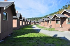 | Cama Beach Resort | district | 2001 | 01000505 |
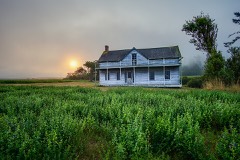 | Central Whidbey Island Historic District | district | 1973 | 73001869 |
| Deception Pass State Park-Cornet Bay Fire Circle | structure | 2019 | 100004769 | |
| Deception Pass State Park-Cornet Bay Incinerator | structure | 2019 | 100004771 | |
| Deception Pass State Park-Cranberry Lake Bathing and Picnic Area Historic District | district | 2019 | 100004770 | |
| Deception Pass State Park-Cranberry Lake Caretaker's Area Historic District | district | 2019 | 100004647 | |
| Deception Pass State Park-North Beach Picnic Area Historic District | district | 2019 | 100004645 | |
| Deception Pass State Park-Rosario and Bowman Bathing, Picnic, and Caretaker's Areas Historic District | district | 2019 | 100004772 | |
| Colonel Granville & Henrietta Haller House | building | 2022 | 100008426 | |
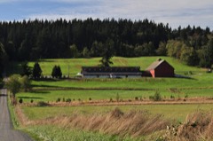 | Kristoferson Dairy | building | 2012 | 11000986 |
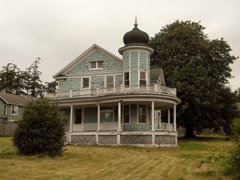 | Benjamin Loers House | building | 1977 | 77001334 |
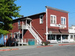 | Olympic Club | building | 1991 | 91000630 |
| Schooner SUVA | structure | 2025 | 100012445 | |
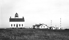 | Smith Island Light Station | site | 1978 | 78002746 |
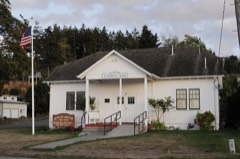 | Utsalady Ladies Aid Building | building | 1998 | 98001186 |
Every wildfire the federal occurrence database records inside this county: 257 of them, burning about 189 acres. 5 started naturally and 11 were recorded as arson. Each settlement page carries the fires within five miles of it.
| Reported cause | Fires |
|---|---|
| Debris and open burning | 94 |
| Recreation and ceremony | 77 |
| Fireworks | 22 |
| Missing data/not specified/undetermined | 17 |
| Smoking | 12 |
| Arson/incendiarism | 11 |
| Misuse of fire by a minor | 11 |
| Natural | 5 |
| Other causes | 4 |
| Equipment and vehicle use | 4 |
The five largest, by the area the report gives. One of them was set deliberately.
| Date | Cause | Size | Reported by | Name on the report |
|---|---|---|---|---|
| 11 October 2003 | Equipment and vehicle use | 18 acres | Washington State Department of Natural Resources Headquarters | not named |
| 1 August 1996 | Fireworks | 15 acres | Washington State Department of Natural Resources Headquarters | not named |
| 3 July 2015 | Missing data/not specified/undetermined | 15 acres | Washington State Department of Natural Resources Headquarters | DOUBLE BLUFF |
| 12 August 1996 | Misuse of fire by a minor | 12 acres | Washington State Department of Natural Resources Headquarters | not named |
| 8 July 2015 | Misuse of fire by a minor | 10 acres | Washington State Department of Natural Resources Headquarters | EBEY |
| 17 September 1995 | Debris and open burning | 5.0 acres | Washington State Department of Natural Resources Headquarters | not named |
| 14 August 1992 | Recreation and ceremony | 5.0 acres | Washington State Department of Natural Resources Headquarters | not named |
| 19 July 2000 | Arson/incendiarism | 5.0 acres | Washington State Department of Natural Resources Headquarters | not named |
Every settlement page carries the fires within five miles of it - see the settlement index below.
The NOAA Storm Events Database holds 6 reports for this county, causing no deaths, no injuries and about $530,000 in recorded property damage. Each settlement page carries the reports that name it.
| Kind of event | Reports |
|---|---|
| Heavy Rain | 2 |
| Debris Flow | 2 |
| Thunderstorm Wind | 1 |
| Flood | 1 |
The most serious of them, by death, then injury, then recorded damage. The accounts are quoted exactly as the forecast office filed them.
| When | Event | Place named | Harm | What the report says |
|---|---|---|---|---|
| December 2014 | Debris Flow | Clinton | $250,000 | A house along the private sidewalk Brighton Boardwalk in Clinton was destroyed by a Sunday afternoon mudslide. The house next door was also damaged. |
| January 2013 | Debris Flow | Clinton | $250,000 | Neighbors are cleaning up after a Wednesday afternoon landslide destroyed a home and damaged others on Whidbey Island. The house that took the brunt of the force was turned almost sideways and is now just inches away from falling into Puget Sound. Nobody was hurt in the 100-yard slide, but a lot of damage was done to several summer homes. |
| December 2007 | Heavy Rain | Clinton | $20,000 | A private school in Clinton was flooded by over an inch of water. |
| April 2009 | Flood | Glendale | $10,000 | Heavy rain over Whidbey Island, from a stationary Puget Sound convergence zone, caused enough flow on Glendale Creek to burst a beaver dam. Subsequent rain and plugging of a culvert on Glendale Road led to part of the road being washed away. The flood stream eventually damaged about 8 homes. |
| August 2001 | Heavy Rain | Countywide | - | no account filed |
| January 1986 | Thunderstorm Wind | not stated | - | no account filed |
The Survey's mineral resources record lists 35 workings inside this county. 8 still produce and 27 are closed or unrecorded. Each settlement page carries the workings within five miles of it.
| Commodity | Workings |
|---|---|
| Sand and Gravel, Construction | 32 |
| REE | 2 |
| Diatomite | 1 |
The least common of them first, because a county's hundredth gravel pit says nothing its first ten did not.
| Where | Site | Commodity | Status | Recorded |
|---|---|---|---|---|
| Useless Bay | Diatomite | Occurrence | ||
| Greenbank Sand & Gravel | REE | Producer | ||
| Henni Pit and Mill | REE | Producer | ||
| Airport Pit | Sand and Gravel, Construction | Past Producer | ||
| Camano Island Pit and Mill | Sand and Gravel, Construction | Past Producer | ||
| Christensen Gravel Pit | Sand and Gravel, Construction | Producer | ||
| Christie Pit | Sand and Gravel, Construction | Past Producer | ||
| Coupeville Pit | Sand and Gravel, Construction | Past Producer | ||
| Erling Pit | Sand and Gravel, Construction | Past Producer | ||
| Everett Bros. | Sand and Gravel, Construction | Producer | ||
| Good Beach Pit | Sand and Gravel, Construction | Past Producer | ||
| Gravel Pit | Sand and Gravel, Construction | Past Producer | ||
| Gravel Pit | Sand and Gravel, Construction | Past Producer | ||
| Harrington Lagoon Pit | Sand and Gravel, Construction | Past Producer | ||
| Island County Road Dept. Pit | Sand and Gravel, Construction | Past Producer | ||
| Island Excavators Pit | Sand and Gravel, Construction | Past Producer | ||
| Keystone Pit | Sand and Gravel, Construction | Past Producer | ||
| Krieg Pit | Sand and Gravel, Construction | Producer | ||
| Libbey-Didco Pit | Sand and Gravel, Construction | Past Producer | ||
| Marine Asphalt Pit 3 | Sand and Gravel, Construction | Past Producer | ||
| Oak Harbor Pit | Sand and Gravel, Construction | Past Producer | ||
| Oak Harbor Pit | Sand and Gravel, Construction | Past Producer | ||
| Oak Harbor Pit | Sand and Gravel, Construction | Past Producer | ||
| Penn Cove Pit | Sand and Gravel, Construction | Past Producer | ||
| Prairie Gravel Pit | Sand and Gravel, Construction | Producer | ||
| Trask Pit | Sand and Gravel, Construction | Past Producer | ||
| Unnamed Pit | Sand and Gravel, Construction | Past Producer | ||
| Unnamed Pit | Sand and Gravel, Construction | Past Producer | ||
| Unnamed Pit | Sand and Gravel, Construction | Past Producer | ||
| Unnamed Pit | Sand and Gravel, Construction | Past Producer | ||
| Unnamed Pit | Sand and Gravel, Construction | Producer | ||
| Veit Asphalt Pit & Plant | Sand and Gravel, Construction | Past Producer | ||
| Whidbey Island Highway 20 Pit | Sand and Gravel, Construction | Past Producer | ||
| Whidbey Island Pit and Mill | Sand and Gravel, Construction | Producer | ||
| Whidbey Pit | Sand and Gravel, Construction | Past Producer |
Named settlements recorded in the Geographic Names Information System, each with the topographic sheets covering it. Villages, hamlets and abandoned places alike. Each is shown with the nearest named watercourse or landform and the survey quadrangle it falls on.
South Whidbey Island census division · 98249 · By Double Bluff · Hansville quadrangle
13 sheets, 1937 to 1997
South Whidbey Island census division · 98260 · Near Baby Island · Freeland quadrangle
14 sheets, 1939 to 1998
South Whidbey Island census division · 98260 · Langley quadrangle
14 sheets, 1911 to 1993
South Whidbey Island census division · 98249 · Freeland quadrangle
14 sheets, 1939 to 1998
Camano Island census division · 98282 · On Camano Island · Camano quadrangle
11 sheets, 1939 to 1993
Central Whidbey Island census division · 98239 · Coupeville quadrangle
10 sheets, 1939 to 1993
South Whidbey Island census division · 98236 · Mukilteo quadrangle
25 sheets, 1895 to 1992
North Whidbey Island census division · 98277 · Near Ben Ure Island · Deception Pass quadrangle
12 sheets, 1943 to 1998
Central Whidbey Island census division · 98239 · Near Ebeys Prairie · Coupeville quadrangle
10 sheets, 1939 to 1993
Central Whidbey Island census division · 98239 · Coupeville quadrangle
10 sheets, 1939 to 1993
Central Whidbey Island census division · 98239 · Near Ebeys Prairie · Coupeville quadrangle
10 sheets, 1939 to 1993
Camano Island census division · 98282 · On Kristoferson Creek · Juniper Beach quadrangle
16 sheets, 1911 to 1993
Central Whidbey Island census division · 98239 · Near Ebeys Prairie · Coupeville quadrangle
10 sheets, 1939 to 1993
Central Whidbey Island census division · 98239 · Coupeville quadrangle
10 sheets, 1939 to 1993
Central Whidbey Island census division · 98253 · By Pratts Bluff · Freeland quadrangle
14 sheets, 1939 to 1998
South Whidbey Island census division · 98249 · Freeland quadrangle
14 sheets, 1939 to 1998
Camano Island census division · 98282 · Juniper Beach quadrangle
16 sheets, 1911 to 1993
Central Whidbey Island census division · 98239 · Coupeville quadrangle
10 sheets, 1939 to 1993
Central Whidbey Island census division · 98239 · Coupeville quadrangle
10 sheets, 1939 to 1993
Camano Island census division · 98282 · On Kristoferson Creek · Juniper Beach quadrangle
16 sheets, 1911 to 1993
Camano Island census division · 98282 · Crescent Harbor quadrangle
14 sheets, 1943 to 1998
North Whidbey Island census division · 98277 · Oak Harbor quadrangle
14 sheets, 1943 to 1998
South Whidbey Island census division · 98236 · Maxwelton quadrangle
25 sheets, 1895 to 1997
South Whidbey Island census division · 98236 · Maxwelton quadrangle
25 sheets, 1895 to 1997
Camano Island census division · 98282 · Juniper Beach quadrangle
16 sheets, 1911 to 1993
North Whidbey Island census division · 98277 · Oak Harbor quadrangle
14 sheets, 1943 to 1998
North Whidbey Island census division · 98277 · By Blowers Bluff · Coupeville quadrangle
10 sheets, 1939 to 1993
Central Whidbey Island census division · 98239 · Near Ebeys Prairie · Coupeville quadrangle
10 sheets, 1939 to 1993
No longer a settlement
South Whidbey Island census division · 98236 · Maxwelton quadrangle
25 sheets, 1895 to 1997
Central Whidbey Island census division · 98239 · Near Ebeys Prairie · Coupeville quadrangle
10 sheets, 1939 to 1993
Camano Island census division · 98282 · Near Camano Island · Camano quadrangle
11 sheets, 1939 to 1993
Central Whidbey Island census division · 98239 · Near Smith Prairie · Coupeville quadrangle
10 sheets, 1939 to 1993
Central Whidbey Island census division · 98239 · Coupeville quadrangle
10 sheets, 1939 to 1993
South Whidbey Island census division · 98236 · Maxwelton quadrangle
25 sheets, 1895 to 1997
Camano Island census division · 98282 · Langley quadrangle
14 sheets, 1911 to 1993
Central Whidbey Island census division · 98239 · Near Ebeys Prairie · Coupeville quadrangle
10 sheets, 1939 to 1993
North Whidbey Island census division · 98277 · Oak Harbor quadrangle
14 sheets, 1943 to 1998
Camano Island census division · 98282 · Juniper Beach quadrangle
16 sheets, 1911 to 1993
The vanished settlements of Island County: the places named above that are no longer on the map.