 Block
From the record
One of 19 National Register listings published here for Stevens County · listed in 1974 · category: Building · built in 1870.
Sources: the case file at the National Archives · the National Register database, National Park Service
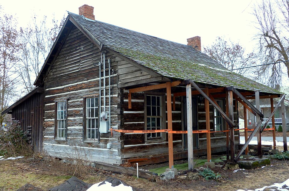
Built in 1870. Listed on the National Register of Historic Places in 1974.
One of 19 National Register listings published here for Stevens County · listed in 1974 · category: Building · built in 1870.
Sources: the case file at the National Archives · the National Register database, National Park Service
Regional context, not property-specific evidence. The federal wildfire occurrence database lists 128 fires within 5 miles of Old Indian Agency between 1992 and 2020, burning about 185 acres in total. 28 started naturally. 1 was recorded as arson. Distance is straight-line from the map coordinates, so a fire counted here may appear on a neighbouring settlement's page as well.
| Reported cause | Fires |
|---|---|
| Debris and open burning | 37 |
| Natural | 28 |
| Missing data/not specified/undetermined | 27 |
| Recreation and ceremony | 9 |
| Power generation/transmission/distribution | 8 |
| Equipment and vehicle use | 6 |
| Other causes | 6 |
| Smoking | 2 |
| Railroad operations and maintenance | 2 |
| Fireworks | 2 |
| Arson/incendiarism | 1 |
The most recent of them, most recent first, with the day each was reported and the service that recorded it.
| Date | Cause | Size | Reported by | Name on the report |
|---|---|---|---|---|
| 8 September 2008 | Missing data/not specified/undetermined | 3.0 acres | Washington State Department of Natural Resources Headquarters | HORSESHOE LAKE |
| 6 September 1998 | Recreation and ceremony | 3.5 acres | Little Pend Oreille National Wildlife Refuge | WEINER |
| 6 September 1998 | Natural | 5.0 acres | Colville National Forest | INCIDENT 136 |
| 6 September 1993 | Debris and open burning | 1.0 acres | Washington State Department of Natural Resources Headquarters | not named |
| 28 September 2009 | Recreation and ceremony | under an acre | Washington State Department of Natural Resources Headquarters | SAND CANYON |
| 23 September 2014 | Natural | under an acre | Colville National Forest | DEVILS CAN |
| 21 September 1992 | Railroad operations and maintenance | under an acre | Washington State Department of Natural Resources Headquarters | not named |
| 21 September 1992 | Railroad operations and maintenance | 1.1 acres | Washington State Department of Natural Resources Headquarters | not named |
Regional context, not property-specific evidence. The federal mineral resources record lists 84 workings within 5 miles of Old Indian Agency: 32 occurrences, 22 prospects, 15 past producers, 8 producers. 8 still produce. What was taken out: Copper, Silver, Sand and Gravel, Construction, Lead. Distance is straight-line from the map coordinates, so a quarry counted here may appear on a neighbouring settlement's page as well.
| Where | Site | Commodity | Status | Recorded |
|---|---|---|---|---|
| Belcher | Copper, Silver, Gold, Lead | Prospect | ||
| Chewelah Eagle | Dolomite, Limestone, Dimension | Producer | ||
| Chewelah Standard | Copper, Silver, Gold, Molybdenum | Occurrence | ||
| Chewelah Standard | Copper, Silver, Molybdenum, Gold | Past Producer | ||
| Chinto | Copper, Silver, Gold, Zinc, Arsenic, Antimony | Occurrence | Chalcopyrite, Pyrite, Sphalerite, Tetrahedrite | |
| Chinto | Copper, Silver, Gold | Past Producer | ||
| Copper Queen | Copper, Gold, Lead, Silver | Past Producer | ||
| Eagle | Silver, Lead, Zinc, Gold, Molybdenum, Copper | Occurrence | ||
| Eagle | Silver, Lead, Gold, Copper, Zinc | Prospect | ||
| Fibco, Inc | Stone, Crushed/Broken | Producer |
Regional context, not property-specific evidence. The National Weather Service names Chewelah, the town this property stands in, in 10 storm reports between 1996 and 2023: 3 hail, 3 flood, 2 thunderstorm wind, 1 flash flood. No death or injury is recorded in these reports. Each account below is quoted exactly as the forecast office filed it, from the NOAA Storm Events Database, and each date opens the federal record of that event.
| When | Event | Place named | Harm | What the report says |
|---|---|---|---|---|
| May 1998 | Flash Flood | Chewelah | $50,000 | Roads flooded in and around Chewelah |
| January 2006 | Flood | Chewelah | $20,000 | Heavy rains over the past week flooded all of the classrooms and the school library on the east end of the Chewelah High School causing 20,000 dollars worth of damage. |
| August 2022 | Thunderstorm Wind | Chewelah | $10,000 | Collapsing thunderstorms caused downed tree limbs and numerous power outages near Chewelah and areas to the southwest. Estimated over 2000 people were without power. Time estimated from radar. No observed gusts were recorded. |
| July 2022 | Lightning | Chewelah | $5,000 | Lightning severely damaged several power poles, downed wires, and ignited a fire on a tree in Chewelah. Time estimated based on dispatch reports and radar. |
| September 2009 | Thunderstorm Wind | Chewelah | $2,000 | Neighbors reported roof damage from strong winds associated with a thunderstorm. |
| May 2011 | Flood | Chewelah | $1,000 | Chewelah Creek flowed out of its banks on May 26th flooding portions of Highway 395, Lincoln Street, and Chewelah City Park. Water had dropped significantly by the |evening of May 28th with only some residual standing water on Lincoln Street. Damage estimates were only for the park and playground equipment. |
| May 2023 | Hail | Chewelah | - | Report was observed near Chewelah. |
| May 2011 | Flood | Chewelah | - | Chewelah Creek rose to bank level on May 12th resulting in portions of Chewelah Park being inundated with water next to the creek. By May 16th, the creek had risen considerably out of its banks with flooding observed over Lincoln Avenue south of the park forcing its closure. The creek continued to rise through May 17th at which time water began flowing over state route 395 between mile post 206.69 and 207.81 forcing its closure as well. Flood waters approached businesses next to the park, but did not appear to make it inside any buildings. |
| May 1997 | Hail | Chewelah | - | sheriff reports 1 inch hail |
| June 1996 | Hail | Chewelah | - | no account filed |
No historic map-sheet match is published for this property yet. That does not mean no map exists. This record needs a coordinate-quality review before it can be joined to a sheet boundary. Browse the county's mapped places while that work is pending.
| National Archives record | The nomination case file for reference 74001981 in Record Group 79. |
| Stevens County | All 19 listed properties in this county. |