
BlockBefore
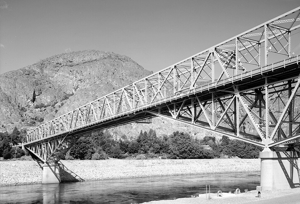
Photograph of Grand Coulee Bridge
Photograph by Jet Lowe, Public domain. Via Wikimedia Commons.

Grand Coulee Bridge

Listed on the National Register of Historic Places in 1982.

From the record

“The Grand Coulee Bridge, or Columbia River Bridge at Grand Coulee Dam, is a through-cantilever steel truss bridge built in 1934-35. It carries State Route 155 across the Columbia River immediately below Grand Coulee Dam, near the city of Grand Coulee, Washington.”

Wikipedia article Grand Coulee Bridge, CC BY-SA 4.0.

One of 16 National Register listings published here for Okanogan County · listed in 1982 · category: Structure.

Sources: the Wikipedia article · the case file at the National Archives · the National Register database, National Park Service

The listing

  • What is counted as historic. The nomination lists 1 structure as contributing to the listing.
  • Address. Spans Columbia River, Grand Coulee, 99116
  • When was it listed? July 1982
  • Category. structure
  • Also known as. Historic Bridges/Tunnels in Washington State TR
  • National Register reference number. 82004267 - the number the National Park Service assigned this property when it was listed, and the key its nomination file is catalogued under at the National Archives.

Fires near this property

85 since 1992

Regional context, not property-specific evidence. The federal wildfire occurrence database lists 85 fires within 5 miles of Grand Coulee Bridge between 1992 and 2020, burning about 25,536 acres in total. 5 started naturally. 9 were recorded as arson. Distance is straight-line from the map coordinates, so a fire counted here may appear on a neighbouring settlement's page as well.

Reported cause Fires
Fireworks19
Missing data/not specified/undetermined17
Arson/incendiarism9
Equipment and vehicle use8
Debris and open burning8
Power generation/transmission/distribution7
Misuse of fire by a minor6
Natural5
Recreation and ceremony3
Other causes2
Smoking1

The most recent of them, most recent first, with the day each was reported and the service that recorded it.

DateCause SizeReported by Name on the report
9 September 1994Arson/incendiarismunder an acreColville AgencyMANILA CR
5 September 2006Missing data/not specified/undeterminedunder an acreColville AgencyELMER CITY TRAILER P
28 September 2018Equipment and vehicle useunder an acreColville AgencyELMER CITY GUARDRAIL
23 September 2007Missing data/not specified/undetermined1.5 acresLake Roosevelt National Recreation AreaSPRING CANYON
2 September 2012Misuse of fire by a minor12 acresColville AgencySEATONS GROVE
19 September 2001Power generation/transmission/distribution227 acresLake Roosevelt National Recreation AreaSPRINGCANY
13 September 1997Debris and open burningunder an acreColville AgencyUSBR DUMP
12 September 2016Missing data/not specified/undetermined230 acresWashington State Fire Marshal's Office230 SWITCH YARD FIRE

Every fire recorded in Okanogan County

Mines and quarries near this property

10 of 23 shown

Regional context, not property-specific evidence. The federal mineral resources record lists 23 workings within 5 miles of Grand Coulee Bridge: 13 past producers, 3 prospects, 3 occurrences, 2 producers. 2 still produce. What was taken out: Sand and Gravel, Construction, Silver, Gold, Molybdenum. Distance is straight-line from the map coordinates, so a quarry counted here may appear on a neighbouring settlement's page as well.

Where SiteCommodity StatusRecorded
Black - RosauerMolybdenum, Silver, Gold, BismuthProducerGalena, Molybdenite, Pyrite
Black-RosauerSilver, Bismuth, Gold, Lead, MolybdenumPast Producer
Coulee City DepositAluminumOccurrence
Electric CityMolybdenum, Bismuth, Gold, Beryllium, SilverProspect
PetersonUraniumOccurrence
State Pit Ps-T-158StonePast Producer
Black Rosauer-Electric CityMolybdenumOccurrence
Hope No. 1Silver, GoldProspect
Silver QueenSilverProspect
Allied Concrete Pit and MillSand and Gravel, ConstructionPast Producer

Every working recorded in Okanogan County

Map coverage status

No historic map-sheet match is published for this property yet. That does not mean no map exists. This record needs a coordinate-quality review before it can be joined to a sheet boundary. Browse the county's mapped places while that work is pending.

Sources for this property

National Archives recordThe nomination case file for reference 82004267 in Record Group 79.
Wikipedia articleCommunity-written account of this property, licensed CC BY-SA.
Okanogan CountyAll 16 listed properties in this county.

Provenance

  • Listing record. National Park Service National Register of Historic Places, listed-properties dataset, current to 2026-05-22.
  • Map join. Address geocoded through the United States Census geocoder, then tested against the published boundary of every sheet in the USGS Historical Topographic Map Collection.
  • How this page is made. Listing fields come from federal records; map-sheet coverage is a labelled coordinate-to-boundary calculation, not a source-field claim.
  • Wildfire. Short, Karen C. 2022. Spatial wildfire occurrence data for the United States, 1992-2020 [FPA_FOD_20221014]. 6th Edition. Fort Collins, CO: Forest Service Research Data Archive. https://doi.org/10.2737/RDS-2013-0009.6 Collected with United States Government funding and usable without additional permissions or fees.
  • Mines and quarries. USGS Mineral Resources Data System (MRDS) https://mrdata.usgs.gov/mrds/ A work of the United States government, no copyright under 17 U.S.C. 105.