 Block
From the record
One of 16 National Register listings published here for Okanogan County · listed in 1982 · category: Building · built in 1896.
Sources: the case file at the National Archives · the National Register database, National Park Service
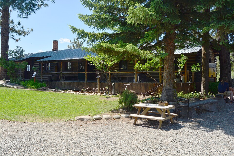
Built in 1896. Listed on the National Register of Historic Places in 1982.
One of 16 National Register listings published here for Okanogan County · listed in 1982 · category: Building · built in 1896.
Sources: the case file at the National Archives · the National Register database, National Park Service
Regional context, not property-specific evidence. The federal wildfire occurrence database lists 137 fires within 5 miles of Guy Waring Cabin between 1992 and 2020, burning about 257,518 acres in total. 50 started naturally. None was recorded as arson. Distance is straight-line from the map coordinates, so a fire counted here may appear on a neighbouring settlement's page as well.
| Reported cause | Fires |
|---|---|
| Natural | 50 |
| Missing data/not specified/undetermined | 28 |
| Debris and open burning | 24 |
| Recreation and ceremony | 20 |
| Power generation/transmission/distribution | 4 |
| Other causes | 3 |
| Smoking | 3 |
| Misuse of fire by a minor | 2 |
| Equipment and vehicle use | 2 |
| Fireworks | 1 |
The most recent of them, most recent first, with the day each was reported and the service that recorded it.
| Date | Cause | Size | Reported by | Name on the report |
|---|---|---|---|---|
| 7 September 2018 | Natural | under an acre | Washington State Department of Natural Resources Headquarters | STUD |
| 7 September 2003 | Recreation and ceremony | under an acre | Washington State Department of Natural Resources Headquarters | not named |
| 6 September 2009 | Natural | under an acre | Okanogan-Wenatchee National Forest | MAGPIE |
| 5 September 1993 | Missing data/not specified/undetermined | 1.2 acres | Okanogan-Wenatchee National Forest | not named |
| 5 September 1992 | Misuse of fire by a minor | under an acre | Okanogan-Wenatchee National Forest | not named |
| 30 September 1999 | Missing data/not specified/undetermined | 6.6 acres | Okanogan-Wenatchee National Forest | EAST CHEWUCH |
| 3 September 2019 | Missing data/not specified/undetermined | 11 acres | Washington State Department of Natural Resources Headquarters | BIG VALLEY |
| 3 September 1996 | Recreation and ceremony | under an acre | Okanogan-Wenatchee National Forest | ELBOW COULEE |
Regional context, not property-specific evidence. The federal mineral resources record lists 12 workings within 5 miles of Guy Waring Cabin: 5 past producers, 4 producers, 2 unknowns, 1 occurrence. 4 still produce. What was taken out: Sand and Gravel, Construction, Stone, Crushed/Broken, Salt, Copper. Distance is straight-line from the map coordinates, so a quarry counted here may appear on a neighbouring settlement's page as well.
| Where | Site | Commodity | Status | Recorded |
|---|---|---|---|---|
| Estes and Yeaple Pre Mix Inc | Salt | Unknown | ||
| Jones Property | Copper, Mercury, Gold, Silver | Occurrence | Cinnabar, Malachite | |
| Twin Lakes Pit | Stone, Crushed/Broken | Producer | ||
| Unnamed Basalt | Stone, Crushed/Broken | Past Producer | ||
| Cascade Concrete Pit | Sand and Gravel, Construction | Producer | ||
| Dept of Highways | Sand and Gravel, Construction | Unknown | ||
| Dept of Highways | Sand and Gravel, Construction | Past Producer | ||
| Dept of Highways | Sand and Gravel, Construction | Past Producer | ||
| Dibble | Sand and Gravel, Construction | Past Producer | ||
| Okanogan County | Sand and Gravel, Construction | Past Producer |
Regional context, not property-specific evidence. The National Weather Service names Winthrop, the town this property stands in, in 16 storm reports between 1999 and 2023: 5 flood, 4 heavy rain, 2 wildfire, 2 flash flood. The reports record 4 deaths and 4 injuries. Each account below is quoted exactly as the forecast office filed it, from the NOAA Storm Events Database, and each date opens the federal record of that event.
| When | Event | Place named | Harm | What the report says |
|---|---|---|---|---|
| July 2001 | Wildfire | Winthrop | 4 killed, 4 hurt | The "Thirtymile" wildfire was in the mop-up stages on July 10 when excessively hot and dry conditions that afternoon caused the smoldering fire to blow up. The fire came roaring back to life, quickly spreading from 25 to 2,500 acres in just three hours. The quickly-spreading fire overran a group of 14 firefighters, causing members of the group to deploy emergency shelters. Four members of the group perished (direct), and four others were hospitalized with injuries. The Thirtymile fire was contained on July 23 after burning a total of 9,300 acres. The cost of fighting this fire exceeded $4.3 million. |
| May 2018 | Flood | Winthrop | $100,000 | Spring time snow melt caused the Chewuch River near Winthrop to rise and cause minor flooding during the second and third weeks of May. Roads and fields along the river were inundated and a few homes suffered yard inundation and first floor minor flooding. |
| July 2016 | Debris Flow | Winthrop | $25,000 | The Forest Service reported that heavy rain from thunderstorms resulted in a road washout on Ramsey Creek Road. A one mile stretch was blocked with mud and debris. The time of the event was estimated. |
| June 2004 | Flash Flood | Winthrop | $10,000 | During the afternoon of June 27th a thunderstorm dumped heavy rain over the upper Chewuch River north of Winthrop. A mud slide resulted with a two acre stretch of mountain side sliding into the Chewuch River. This caused the river to change course and inundate the forest road along the river. |
| July 2023 | Flash Flood | Winthrop | $5,000 | Multiple reports of flash flooding two miles Northwest of Winthrop. Mud and debris on road reports for West Chewuch Road, Highway 20, and Wright Road. Methow Valley Airport recorded 0.9 of an inch fell in an hour and half. |
| June 2011 | Flood | Winthrop | $3,000 | A combination of landslides and flooding along creeks and rivers resulted in the closure of numerous campsites within Perygian State Park through the first two weeks of June. Damage costs were estimated based on an average loss of revenue from closed campgrounds. |
| April 2018 | Debris Flow | Winthrop | $2,000 | A debris flow was reported blocking West Chewuch Road. |
| July 2016 | Flood | Winthrop | $1,000 | A member of law enforcement reported heavy rainfall from a thunderstorm resulted in water over Bear Creek Road about 2 miles northeast of Winthrop, WA. |
| July 2016 | Flood | Winthrop | $1,000 | A member of law enforcement reported heavy rainfall from a passing thunderstorm resulted in a minor debris flow of rocks and water over Elbow Coulee Road which is about 5 miles south southwest of Winthrop, WA. |
| July 2016 | Flood | Winthrop | $1,000 | A member of law enforcement reported heavy rainfall from a thunderstorm resulted in water over the road at highway 20 in Winthrop, WA. |
| August 1999 | Heavy Rain | Winthrop | - | 1.15" of rain in three hours |
| August 1999 | Wildfire | Winthrop | - | 200 Acre fire 8S of Winthrop |
| July 2010 | Heavy Rain | Winthrop | - | no account filed |
| June 2010 | Heavy Rain | Winthrop | - | no account filed |
| May 2010 | Heavy Rain | Winthrop | - | no account filed |
| July 2006 | Thunderstorm Wind | Winthrop | - | no account filed |
No historic map-sheet match is published for this property yet. That does not mean no map exists. This record needs a coordinate-quality review before it can be joined to a sheet boundary. Browse the county's mapped places while that work is pending.
| National Archives record | The nomination case file for reference 82004268 in Record Group 79. |
| Okanogan County | All 16 listed properties in this county. |