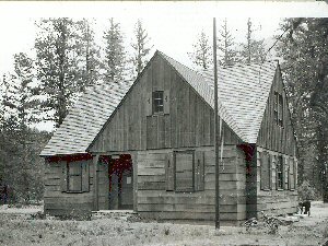
Listed on the National Register of Historic Places in 1986.
From the record
“The Early Winters Ranger Station Work Center in the Okanogan-Wenatchee National Forest near Winthrop, Washington was built in 1936 by the Civilian Conservation Corps. It was listed on the National Register of Historic Places in 1986 for its architecture.”
Wikipedia article Early Winters Ranger Station Work Center, CC BY-SA 4.0.
One of 16 National Register listings published here for Okanogan County · listed in 1986 · category: Building.
Also known as. Depression-Era Buildings TR; Depression-Era Buildings Oregon and Washington TR
Census division. Methow Valley
National Register reference number.86000841- the number the National Park Service assigned this property when it was listed, and the key its nomination file is catalogued under at the National Archives.
Fires near this property
102 since 1992
Regional context, not property-specific
evidence. The
federal wildfire occurrence database
lists 102 fires within 5 miles of Early Winters Ranger Station Work Center
between 1992 and 2020, burning about 41 acres in total. 67 started naturally. 1 was recorded as arson.
Distance is straight-line from the map coordinates, so a fire counted
here may appear on a neighbouring settlement's page as well.
Reported cause
Fires
Natural
67
Missing data/not specified/undetermined
11
Recreation and ceremony
9
Debris and open burning
7
Smoking
3
Power generation/transmission/distribution
2
Other causes
2
Arson/incendiarism
1
The most recent of
them, most recent first, with the day each was reported and the service
that recorded it.
Date
Cause
Size
Reported by
Name on the report
9 September 2019
Natural
under an acre
Okanogan-Wenatchee National Forest
VARDEN
9 September 2012
Natural
under an acre
Okanogan-Wenatchee National Forest
HUCKLEBERRY
8 September 2019
Natural
under an acre
Okanogan-Wenatchee National Forest
MONTANA MINE
3 September 2001
Recreation and ceremony
under an acre
Okanogan-Wenatchee National Forest
KLIPCHUCK
20 September 2020
Natural
under an acre
Okanogan-Wenatchee National Forest
PEKIN
19 September 2020
Natural
under an acre
Okanogan-Wenatchee National Forest
VARDEN 2
16 September 2020
Missing data/not specified/undetermined
under an acre
Washington State Department of Natural Resources Headquarters
Regional context, not property-specific
evidence. The federal mineral resources record lists
31 workings within 5 miles of Early Winters Ranger Station Work Center: 11 past producers, 11 prospects, 4 unknowns, 4 occurrences.
1 still produces. What was taken out: Copper, Gold, Sand and Gravel, Construction, Silver, Copper. Distance is straight-line from the
map coordinates, so a quarry counted here may appear on a neighbouring
settlement's page as well.
Regional context, not property-specific
evidence. The National Weather Service names
Winthrop, the town this property stands in, in 16 storm reports between 1999 and 2023: 5 flood, 4 heavy rain, 2 wildfire, 2 flash flood.
The reports record 4 deaths and 4 injuries. Each account below is quoted exactly as the forecast office
filed it, from the NOAA Storm Events Database, and each date
opens the federal record of that event.
The "Thirtymile" wildfire was in the mop-up stages on July 10 when excessively hot and dry conditions that afternoon caused the smoldering fire to blow up. The fire came roaring back to life, quickly spreading from 25 to 2,500 acres in just three hours. The quickly-spreading fire overran a group of 14 firefighters, causing members of the group to deploy emergency shelters. Four members of the group perished (direct), and four others were hospitalized with injuries. The Thirtymile fire was contained on July 23 after burning a total of 9,300 acres. The cost of fighting this fire exceeded $4.3 million.
Spring time snow melt caused the Chewuch River near Winthrop to rise and cause minor flooding during the second and third weeks of May. Roads and fields along the river were inundated and a few homes suffered yard inundation and first floor minor flooding.
The Forest Service reported that heavy rain from thunderstorms resulted in a road washout on Ramsey Creek Road. A one mile stretch was blocked with mud and debris. The time of the event was estimated.
During the afternoon of June 27th a thunderstorm dumped heavy rain over the upper Chewuch River north of Winthrop. A mud slide resulted with a two acre stretch of mountain side sliding into the Chewuch River. This caused the river to change course and inundate the forest road along the river.
Multiple reports of flash flooding two miles Northwest of Winthrop. Mud and debris on road reports for West Chewuch Road, Highway 20, and Wright Road. Methow Valley Airport recorded 0.9 of an inch fell in an hour and half.
A combination of landslides and flooding along creeks and rivers resulted in the closure of numerous campsites within Perygian State Park through the first two weeks of June. Damage costs were estimated based on an average loss of revenue from closed campgrounds.
A member of law enforcement reported heavy rainfall from a thunderstorm resulted in water over Bear Creek Road about 2 miles northeast of Winthrop, WA.
A member of law enforcement reported heavy rainfall from a passing thunderstorm resulted in a minor debris flow of rocks and water over Elbow Coulee Road which is about 5 miles south southwest of Winthrop, WA.
No historic map-sheet match is published
for this property yet. That does not mean no map exists. This record needs
a coordinate-quality review before it can be joined to a sheet boundary.
Browse the county's mapped places while that work is
pending.
Listing record. National Park Service National Register of Historic Places, listed-properties dataset, current to 2026-05-22.
Map join. Address geocoded through the United States Census geocoder, then tested against the published boundary of every sheet in the USGS Historical Topographic Map Collection.
How this page is made. Listing fields come from federal records; map-sheet coverage is a labelled coordinate-to-boundary calculation, not a source-field claim.
Wildfire. Short, Karen C. 2022. Spatial wildfire occurrence data for the United States, 1992-2020 [FPA_FOD_20221014]. 6th Edition. Fort Collins, CO: Forest Service Research Data Archive. https://doi.org/10.2737/RDS-2013-0009.6 Collected with United States Government funding and usable without additional permissions or fees.
Mines and quarries. USGS Mineral Resources Data System (MRDS) https://mrdata.usgs.gov/mrds/ A work of the United States government, no copyright under 17 U.S.C. 105.
Storms. NOAA National Centers for Environmental Information, Storm Events Database https://www.ncei.noaa.gov/stormevents/ A work of the United States government, no copyright under 17 U.S.C. 105. Narratives are quoted verbatim from the National Weather Service report and are not edited or summarised.
 Block