 Block
From the record
2 National Register listings published here.
Sources: the National Register database, National Park Service
51 topographic sheets cover 26 settlements here, and 2 properties are on the National Register of Historic Places.
2 National Register listings published here.
Sources: the National Register database, National Park Service
Every property in this county listed on the National Register of Historic Places, with the year it was listed and the federal nomination document.
| Photograph | Property | Type | Listed | Reference |
|---|---|---|---|---|
 | Adams County Courthouse | building | 1982 | 82000627 |
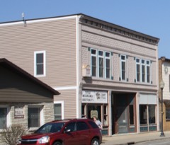 | Gunning-Purves Building | building | 2015 | 15000056 |
Every wildfire the federal occurrence database records inside this county: 1,474 of them, burning about 5,633 acres. 20 started naturally and 103 were recorded as arson. Each settlement page carries the fires within five miles of it.
| Reported cause | Fires |
|---|---|
| Debris and open burning | 447 |
| Equipment and vehicle use | 281 |
| Missing data/not specified/undetermined | 275 |
| Arson/incendiarism | 103 |
| Recreation and ceremony | 96 |
| Railroad operations and maintenance | 52 |
| Smoking | 50 |
| Power generation/transmission/distribution | 48 |
| Misuse of fire by a minor | 36 |
| Other causes | 34 |
| Fireworks | 32 |
| Natural | 20 |
The five largest, by the area the report gives. One of them was set deliberately.
| Date | Cause | Size | Reported by | Name on the report |
|---|---|---|---|---|
| 5 May 2005 | Debris and open burning | 3,410 acres | Wisconsin Department of Natural Resources | COTTONVILLE |
| 13 April 1998 | Arson/incendiarism | 160 acres | Wisconsin Department of Natural Resources | not named |
| 17 April 2009 | Debris and open burning | 106 acres | Wisconsin Department of Natural Resources | EASTON 2 |
| 23 October 1999 | Smoking | 62 acres | Wisconsin Department of Natural Resources | not named |
| 23 April 2001 | Debris and open burning | 60 acres | Wisconsin Department of Natural Resources | not named |
| 9 April 1994 | Debris and open burning | 55 acres | Wisconsin Department of Natural Resources | not named |
| 3 April 1995 | Debris and open burning | 40 acres | Wisconsin Department of Natural Resources | not named |
| 20 March 2006 | Railroad operations and maintenance | 40 acres | Wisconsin Department of Natural Resources | not named |
Every settlement page carries the fires within five miles of it - see the settlement index below.
The NOAA Storm Events Database holds 324 reports for this county, causing no deaths, 26 injuries and about $17,268,010 in recorded property damage. Each settlement page carries the reports that name it.
| Kind of event | Reports |
|---|---|
| Thunderstorm Wind | 167 |
| Hail | 109 |
| Tornado | 17 |
| Flood | 12 |
| Flash Flood | 7 |
| Lightning | 6 |
| Heavy Rain | 3 |
| Funnel Cloud | 2 |
| Wildfire | 1 |
The most serious of them, by death, then injury, then recorded damage. The accounts are quoted exactly as the forecast office filed them.
| When | Event | Place named | Harm | What the report says |
|---|---|---|---|---|
| June 2004 | Tornado (F1) | White Creek | 13 hurt, $100,000 | no account filed |
| May 1971 | Tornado (F1) | not stated | 5 hurt, $250,000 | no account filed |
| June 2004 | Thunderstorm Wind | Brooks | 5 hurt, $60,000 | no account filed |
| September 2000 | Thunderstorm Wind | Easton | 3 hurt, $50,000 | no account filed |
| August 2018 | Thunderstorm Wind | Plainville | $6,000,000 | Thousands of trees were blown down or snapped across southern Adams County. The damage was south of State Highway 82 across Springville and Jackson Townships. The damage started just south of the intersection of State Highways 13 and 82 and continued east to the Marquette County line east of Jordan Lake and was 3 to 4 miles wide in some spots. Some of the downed trees landed on houses. On Jordan Lake, boats were dislodged from docks and floated out into the lake. |
| April 2011 | Tornado (EF2) | Causeway | $3,300,000 | A National Weather Service storm survey team confirmed an EF2 tornado that tracked from approximately three miles west of Arkdale to County Road G. The tornado caused extensive damage to barns, trees, and parts of a house two miles west of Arkdale. A cement silo was knocked over as well. The tornado crossed Highway 21 north of Arkdale hitting nearby homes, irrigation systems, and hundreds of trees. A very distinct convergent pattern was noted in the trees at this location with winds estimated around 125 mph. Several more farms, homes, and trees were hit as the tornado continued toward the south side of Big Roche A Cri Lake near the small community of Cottonville. Several cars and mobile homes were flipped or heavily damage. A lake association building on the southwest side of Big Roche A Cri Lake was completely destroyed and numerous center-pivot irrigation systems were twisted or destroyed across the county. EF2 damage was noted as the tornado widened to nearly a half mile wide. It crossed Highway 13 at Cottonville and gradually began to weaken hitting more seasonal homes, trees, and roof tops. The tornado dissipated south of the Colburn Wildlife area. |
| July 1984 | Tornado (F2) | not stated | $2,500,000 | no account filed |
| August 2018 | Flash Flood | Easton | $780,000 | Runoff from heavy rains produced flash flooding across the southern sections of Adams County. County Highway G was closed because of flooding along Big Spring Creek and water was over County Highway H near White Creek. Additional township roads were closed or had water over them. |
| March 2019 | Flood | New Rome | $750,000 | Runoff from melting snow caused flooding to occur along numerous streams across Adams County. Most county highways were impacted by water with numerous closures. Some homes had water in the basements or first floor. Almost 20 homes sustained minor damage with 5 homes and businesses sustaining major damage. At least two drivers unknowingly drove into washouts on county roads. A county-wide state of emergency was declared. |
| June 2002 | Flash Flood | Northeast Portion | $577,000 | no account filed |
| April 2011 | Tornado (EF1) | Big Flats | $426,000 | A National Weather Service storm survey team confirmed that a second tornado formed near County Road G and Buttercup Ave. north of where the Arkdale to Cottonville tornado dissipated. EF1 damage was noted to some homes and trees, especially along Buttercup Ave. as the tornado tracked into Waushara County. Several center-post irrigation systems were destroyed along with some roof damage to homes and power poles. |
| June 2000 | Thunderstorm Wind | Countywide | $250,000 | no account filed |
| April 1984 | Tornado (F1) | not stated | $250,000 | no account filed |
| June 2004 | Flash Flood | North Portion | $125,000 | no account filed |
| September 2016 | Flash Flood | Plainville | $116,000 | Runoff from heavy rain caused flood waters from Big Spring Creek to washout a section of County Highway G northwest of Big Spring. Flood waters from Big Spring Creek also covered County Highway P near Big Spring. Flooding elsewhere in the county damaged three homes. |
| March 1998 | Hail | New Rome | $100,000 | no account filed |
| September 2010 | Flood | Adams | $91,000 | County Road Z was underwater between County Road H and State Highway 82. Gem Court was underwater west of State Highway 13 and the shoreline along Castle Rock Lake was flooded near the dam. There were 8 homes and 1 business that incurred minor damage due to the flooding. |
| April 1998 | Wildfire | New Rome | $80,000 | no account filed |
| July 2023 | Thunderstorm Wind | Strongs Prairie | $75,000 | Public reported multiple fallen mature trees near and west of Arkdale along Wisconsin State Highway 21. |
| May 2000 | Hail | Friendship | $70,000 | no account filed |
| July 2023 | Thunderstorm Wind | Monroe Center | $65,000 | Public reported fallen mature pine trees and power outages near Monroe Center. |
| July 2023 | Thunderstorm Wind | Monroe Center | $65,000 | Public reported fallen mature pine trees and power outages in Monroe Center. |
| May 2000 | Hail | Big Flats | $60,000 | no account filed |
| September 1997 | Thunderstorm Wind | Friendship | $55,000 | no account filed |
| April 1994 | Thunderstorm Wind | Dellwood | $50,000 | no account filed |
| July 1997 | Thunderstorm Wind | Colburn | $45,000 | no account filed |
| May 2025 | Hail | Friendship | $30,000 | Law enforcement reported golf ball sized hail 1 mile southeast of Friendship. |
| June 2022 | Thunderstorm Wind | White Creek | $30,000 | A mobile home was damaged by winds southwest of Grand Marsh. |
| July 2015 | Thunderstorm Wind | Monroe Center | $30,000 | Trees were blown down east of Monroe Center where at least one house was damaged when a tree fell on it. |
| September 2011 | Thunderstorm Wind | Adams | $30,000 | Trees and power lines were blown down across portions of Adams County. The downed trees blocked roadways and fell on top of homes and cars. According to the emergency manager, it appears that Preston Township in the central part of the county, was hit the hardest with downed trees. |
| July 1997 | Flash Flood | Grand Marsh | $30,000 | no account filed |
| June 2022 | Thunderstorm Wind | Easton | $25,000 | Extensive tree damage occurred west of White Creek in the Quincy Bluffs area. |
| June 2022 | Thunderstorm Wind | White Creek | $25,000 | Trees were blown down and irrigation equipment flipped east of White Creek in the Easton area. |
| June 2016 | Thunderstorm Wind | Monroe Center | $25,000 | An estimated 70 mph wind gust occurred near Monroe Center. Several trees were blown down near Petenwell Lake and in Monroe Center. Some of these trees landed on houses in Monroe Center. Power lines were also taken down by the storm. |
| August 2006 | Hail | Brooks | $25,000 | no account filed |
| July 2002 | Thunderstorm Wind | New Rome | $25,000 | no account filed |
| August 1992 | Tornado (F1) | not stated | $25,000 | no account filed |
| May 1989 | Tornado (F0) | not stated | $25,000 | no account filed |
| July 1983 | Tornado (F1) | not stated | $25,000 | no account filed |
| July 1980 | Tornado (F2) | not stated | $25,000 | no account filed |
| April 1975 | Tornado (F0) | not stated | $25,000 | no account filed |
| June 1974 | Tornado (F1) | not stated | $25,000 | no account filed |
| July 2017 | Thunderstorm Wind | Brooks | $20,000 | Power poles were broken southeast of Brooks. |
| July 2015 | Lightning | New Rome | $20,000 | A house located near Lake Camelot sustained significant fire and water damage from a fire started by a lightning strike. The lightning strike also damaged the phone lines of a neighboring house. |
| May 1998 | Thunderstorm Wind | Friendship | $20,000 | no account filed |
| September 1998 | Hail | Dellwood | $20,000 | no account filed |
| June 2025 | Thunderstorm Wind | Dellwood | $15,000 | Local broadcast media reported a big pine tree blown over along with some boats 4 miles south-southeast of Dellwood. |
| October 2006 | Hail | Big Flats | $15,000 | no account filed |
| July 2003 | Thunderstorm Wind | Easton | $15,000 | no account filed |
| September 1998 | Hail | Grand Marsh | $15,000 | no account filed |
| August 2000 | Lightning | Easton | $13,000 | no account filed |
| June 1998 | Thunderstorm Wind | Adams | $12,000 | no account filed |
| August 1998 | Thunderstorm Wind | Friendship | $12,000 | no account filed |
| August 2025 | Thunderstorm Wind | Plainville | $10,000 | An amateur radio operator reported trees down on Freedom Ct with powerlines down 3 miles north of Plainville. |
| June 2019 | Lightning | New Rome | $10,000 | A lightning strike from a thunderstorm struck a parked boat near Lake Camelot east of Rome. The resulting fire destroyed the boat and damaged some trees. |
| August 2007 | Thunderstorm Wind | Adams | $10,000 | Numerous trees were blown down, several on nearby homes. Power lines were also knocked down causing house fires. Railroad crossings were also blown down. |
| October 2006 | Hail | White Creek | $10,000 | no account filed |
| October 2006 | Hail | Frndshp Adams Co Arp | $10,000 | no account filed |
| June 1998 | Thunderstorm Wind | Arkdale | $10,000 | no account filed |
| September 1997 | Thunderstorm Wind | Big Flats | $10,000 | no account filed |
The Survey's mineral resources record lists 8 workings inside this county. 6 still produce and 2 are closed or unrecorded. Each settlement page carries the workings within five miles of it.
| Commodity | Workings |
|---|---|
| Sand and Gravel, Construction | 8 |
The least common of them first, because a county's hundredth gravel pit says nothing its first ten did not.
| Where | Site | Commodity | Status | Recorded |
|---|---|---|---|---|
| Adams Co. Hwy. Dept. | Sand and Gravel, Construction | Producer | ||
| Adams County Operations | Sand and Gravel, Construction | Producer | ||
| Butera Pit | Sand and Gravel, Construction | Past Producer | ||
| D. Patterson Pit | Sand and Gravel, Construction | Producer | ||
| Oxford Pit | Sand and Gravel, Construction | Past Producer | ||
| Oxford Wash Plant | Sand and Gravel, Construction | Plant | ||
| Seven Sisters Pit | Sand and Gravel, Construction | Producer | ||
| Werner Pit | Sand and Gravel, Construction | Producer |
Named settlements recorded in the Geographic Names Information System, each with the topographic sheets covering it. Villages, hamlets and abandoned places alike. Each is shown with the nearest named watercourse or landform and the survey quadrangle it falls on.
New Haven town · 53965 · On Big Spring Creek · Big Spring quadrangle
15 sheets, 1902 to 1990
Dell Prairie town · 53965 · Big Spring quadrangle
15 sheets, 1902 to 1990
No longer a settlement
Strongs Prairie town · 54613 · On Little Roche a Cri Creek · Dellwood quadrangle
10 sheets, 1957 to 1990
Adams town · 53934 · By Preston Cliffs · Grand Marsh quadrangle
11 sheets, 1957 to 1990
No longer a settlement
New Chester town · 53952 · Brooks quadrangle
10 sheets, 1957 to 1990
No longer a settlement
Rome town · 54457 · On Chester Creek · Arkdale NE quadrangle
7 sheets, 1955 to 1985
No longer a settlement
Richfield town · 54930 · By Horseshoe Bluff · Westfield West quadrangle
11 sheets, 1957 to 1990
No longer a settlement
Dell Prairie town · 53965 · On Plainville Creek · Wisconsin Dells North quadrangle
16 sheets, 1901 to 1990
Preston town · 53934 · On Dead Horse Creek · Roche A Cri quadrangle
7 sheets, 1955 to 1985
No longer a settlement
Lincoln town · 53936 · Grand Marsh quadrangle
11 sheets, 1957 to 1990
No longer a settlement
The vanished settlements of Adams County: the places named above that are no longer on the map.