 Block
From the record
5 National Register listings published here.
Sources: the National Register database, National Park Service
42 topographic sheets cover 34 settlements here, and 5 properties are on the National Register of Historic Places.
5 National Register listings published here.
Sources: the National Register database, National Park Service
Every property in this county listed on the National Register of Historic Places, with the year it was listed and the federal nomination document.
| Photograph | Property | Type | Listed | Reference |
|---|---|---|---|---|
 | Calumet County Courthouse | building | 1982 | 82000640 |
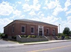 | Chilton Post Office | building | 2000 | 00001249 |
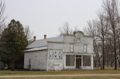 | Haese Memorial Village Historic District | district | 1982 | 82000641 |
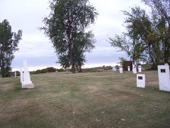 | Stockridge Indian Cemetery | site | 1980 | 80000111 |
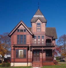 | Herman C. Timm House | building | 1996 | 96000727 |
Every wildfire the federal occurrence database records inside this county: 22 of them, burning about 42 acres. 1 started naturally and 1 was recorded as arson. Each settlement page carries the fires within five miles of it.
| Reported cause | Fires |
|---|---|
| Missing data/not specified/undetermined | 9 |
| Debris and open burning | 5 |
| Equipment and vehicle use | 4 |
| Natural | 1 |
| Arson/incendiarism | 1 |
| Fireworks | 1 |
| Smoking | 1 |
The five largest, by the area the report gives. None of them was recorded as arson.
| Date | Cause | Size | Reported by | Name on the report |
|---|---|---|---|---|
| 19 October 2010 | Equipment and vehicle use | 18 acres | Wisconsin Department of Natural Resources | not named |
| 10 November 2020 | Debris and open burning | 7.0 acres | Wisconsin Department of Natural Resources | 92 |
| 23 May 1997 | Equipment and vehicle use | 5.0 acres | Wisconsin Department of Natural Resources | not named |
| 14 June 2020 | Equipment and vehicle use | 4.0 acres | Wisconsin Department of Natural Resources | 47 |
| 1 May 2020 | Missing data/not specified/undetermined | 2.0 acres | Wisconsin Department of Natural Resources | 31 |
| 2 June 2020 | Natural | 1.0 acres | Wisconsin Department of Natural Resources | 41 |
| 5 November 2020 | Equipment and vehicle use | 1.0 acres | Wisconsin Department of Natural Resources | 84 |
| 27 May 2018 | Fireworks | 1.0 acres | Wisconsin Department of Natural Resources | 32 |
Every settlement page carries the fires within five miles of it - see the settlement index below.
The NOAA Storm Events Database holds 279 reports for this county, causing 2 deaths, 8 injuries and about $45,171,500 in recorded property damage. Each settlement page carries the reports that name it.
| Kind of event | Reports |
|---|---|
| Thunderstorm Wind | 118 |
| Hail | 95 |
| Tornado | 24 |
| Funnel Cloud | 13 |
| Flash Flood | 11 |
| Heavy Rain | 8 |
| Lightning | 5 |
| Flood | 4 |
| Waterspout | 1 |
The most serious of them, by death, then injury, then recorded damage. The accounts are quoted exactly as the forecast office filed them.
| When | Event | Place named | Harm | What the report says |
|---|---|---|---|---|
| August 1979 | Tornado (F2) | not stated | 1 killed, $25,000 | no account filed |
| June 1997 | Lightning | New Holstein | 1 killed | no account filed |
| April 1981 | Tornado (F2) | not stated | 6 hurt, $250,000 | no account filed |
| June 1967 | Tornado (F2) | not stated | 1 hurt, $250,000 | no account filed |
| August 1988 | Thunderstorm Wind | not stated | 1 hurt | no account filed |
| May 2000 | Hail | Stockbridge | $32,200,000 | no account filed |
| May 2002 | Hail | Appleton | $4,900,000 | no account filed |
| May 1964 | Tornado (F2) | not stated | $2,500,000 | no account filed |
| April 2006 | Thunderstorm Wind | Hilbert | $1,000,000 | no account filed |
| May 1998 | Thunderstorm Wind | Sherwood | $500,000 | no account filed |
| June 2008 | Flash Flood | St Anna | $480,000 | Torrential rain flooded roads and washed out a 10 foot section of railroad ties near Highway BB south of St. John. Numerous streets and basements were flooded and the St. Ana Fire Department needed to be sand bagged to avoid flooding. The flooding caused major damage to 1 home and minor damage to 60 others. |
| May 2018 | Flood | High Cliff Jct | $300,000 | Heavy rainfall caused rivers, roads and basements to flood. The flooding washed out several roads throughout the county. |
| July 2010 | Hail | Darboy | $300,000 | Half dollar size hail and strong winds caused damage to 150 homes near Darboy. The homes sustained at least minor damage to roofs and siding. |
| July 2006 | Hail | Potter | $300,000 | no account filed |
| May 1998 | Tornado (F1) | Stockbridge | $300,000 | no account filed |
| May 2012 | Flash Flood | Harrison | $250,000 | Flash flooding caused authorities to close many roads across Calumet County. The Village of Hilbert sustained the worst flooding, with approximately 100 homes impacted. A flooded creek washed out a section of asphalt on Cemetery Road near Forest Junction and ripped away the culvert. One motorist was injured while attempting to cross the missing section of road during the predawn hours. The driver was hospitalized and the front wheels were torn from the vehicle. |
| May 1989 | Tornado (F1) | not stated | $250,000 | no account filed |
| July 1983 | Tornado (F1) | not stated | $250,000 | no account filed |
| August 2013 | Tornado (EF1) | Forest Jct | $200,000 | The tornado that formed in Outagamie County 3.5 miles east of Greenville at 12:38 am CDT, and briefly moved across Brown County, entered Calumet County 1.6 miles north of Forest Junction at 12:50 am CDT. The tornado damaged about three dozen trees (DI 28, DOD 3 and 4). Two metal truss towers collapsed under the weight of several high voltage power lines (that weighed two pounds per foot) which were likely moving in unison as their resonance frequency was reached. Engineers that inspected the damage estimated winds of 100 mph. Nearby trees sustained relatively minor damage (DI 28, DOD 2 and 3). The average path width in Calumet County was 125 yards. |
| July 2010 | Flash Flood | Stockbridge | $140,000 | A thunderstorm produced very heavy rain in only a couple of hours in Calumet County near Stockbridge. Between 3:00 am and 4:00 am, 2.6 inches of rain fell, with a storm total of 4.40 inches recorded. The heavy rainfall caused a portion of a road to collapse along a drainage ditch which leads into Mud Creek. Several other county roads suffered damage from the fast moving water and a home experienced damage as water rushed into the structure's basement. |
| April 2011 | Tornado (EF1) | Quinney | $100,000 | A brief tornado moved off Lake Winnebago and onshore south of Stockbridge just before 9:00 pm CDT (2000 CST). The waterspout was seen as it moved onto the shore, damaging two homes. A three-season room on one of the houses was ripped off the structure (DI 2, DOD 4). The tornado moved northeast and tore off a section of the roof of a large outbuilding (DI 1, DOD 4). The tops of trees were snapped in two areas along the path of the tornado. The average path width was 75 yards. |
| July 2008 | Hail | High Cliff | $100,000 | Hail up to 2 inches in diameter caused damage to approximately 20 homes and several cars. |
| July 2021 | Lightning | Kiel | $75,000 | Lightning struck a house on 10th Street in Kiel and causing a fire and extensive damage. |
| August 2009 | Lightning | Gravesville | $75,000 | Lightning struck a home in Collins at about 4:30 AM CDT, which started a two story farm house on fire. The occupants were able to safely evacuate. The fire did major damage to the structure. Part of the roof collapsed and a portion of the second floor fell onto the first floor. |
| September 2011 | Thunderstorm Wind | Chilton | $70,000 | Thunderstorm winds uprooted large trees at the county fair grounds and damaged several vehicles and campers. The high winds also caused scattered power outages. |
| March 2019 | Flood | High Cliff Jct | $55,000 | Runoff from rainfall and melting snow, along with clogged storm drains and ice jams, caused numerous roads, ditches, rivers and streams to flood throughout Calumet County. Some of the roads were damaged by the flooding and required repairs after the water receded. |
| August 2011 | Tornado (EF0) | Sherwood | $50,000 | A tornado struck less than a mile northeast of Sherwood at 9:05 PM CDT. The EF0 tornado toppled two trees that damaged the roof of a house and snapped or uprooted six pine trees near Highway M. The tornado continued east-southeast, moving over a swamp, where swirl marks were seen in the thick swamp grass. The tornado then hit a farm on Kesler Road. Two old barns were heavily damaged (DI 1, DOD 5, 6 -- lower bound due to condition of structures). Peak winds were estimated near 85 mph. Average path width of the tornado was 75 yards. |
| September 2019 | Flash Flood | Darboy | $30,000 | Street closed due to flash flooding and vehicles stranded in Darboy. A culvert was washed out in the village of Sherwood. |
| July 2016 | Lightning | New Holstein | $25,000 | Lightning stuck a house in New Holstein, causing roof damage. |
| June 2014 | Heavy Rain | Stockbridge | $25,000 | Thunderstorms produced heavy rain in parts of central and southern Calumet County. 3.38 of rain fell near Stockbridge in less than three hours. The heavy rain caused fields to flood and washed out culverts of several area roads. Several houses had water in their basements. |
| July 2006 | Thunderstorm Wind | Potter | $25,000 | no account filed |
| July 1965 | Tornado (F2) | not stated | $25,000 | no account filed |
| July 2015 | Thunderstorm Wind | St John | $15,000 | Thunderstorm winds damaged a metal outbuilding along CR-BB east of Sherwood. |
| July 2007 | Thunderstorm Wind | New Holstein | $15,000 | Straight-line winds from a thunderstorm, likely a wet microburst, downed trees and branches and flooded area roads. The high winds blew two airplanes into each other at New Holstein Municipal Airport when a tie-down broke loose, threw a tree branch through the top of another plane's wing and flipped a pop-up camper severely damaging it. |
| July 1999 | Lightning | Appleton | $12,000 | no account filed |
| July 2006 | Thunderstorm Wind | Hilbert | $10,000 | no account filed |
| May 1998 | Thunderstorm Wind | New Holstein | $10,000 | no account filed |
| June 2012 | Thunderstorm Wind | Darboy | $5,000 | Thunderstorm winds knocked a tree onto a home on Fire Lane 8, on the shore of Lake Winnebago. The tree caused damage to the roof of the house and broke a window. |
| April 2002 | Thunderstorm Wind | Chilton | $5,000 | no account filed |
| May 1998 | Thunderstorm Wind | Chilton | $5,000 | no account filed |
| July 1997 | Thunderstorm Wind | Sherwood | $5,000 | no account filed |
| August 1996 | Thunderstorm Wind | Chilton | $5,000 | no account filed |
| July 2010 | Heavy Rain | Stockbridge | $4,000 | Heavy rainfall around Stockbridge washed out a section of Mapleview Lane and the shoulder along County Highway E about 2 miles east of town. One basement sustained water damage. The Calumet County Emergency Manager reported a measured rainfall total of 3.45 inches at Chilton, about 8 miles away, between 4:15 pm and 9:15 pm CST. |
| July 2021 | Thunderstorm Wind | Harrison | $3,500 | Thunderstorm winds damaged a sturdy large wooden playset. |
| August 2015 | Thunderstorm Wind | Chilton | $3,000 | Thunderstorm winds downed trees in Chilton. |
| July 2006 | Thunderstorm Wind | Brothertown | $3,000 | no account filed |
| April 2020 | Thunderstorm Wind | Hilbert | $2,000 | Thunderstorm winds tipped over and damaged a large play set. The time of this event is an estimate based on radar data. |
| July 2006 | Thunderstorm Wind | Stockbridge | $2,000 | no account filed |
| July 1997 | Thunderstorm Wind | New Holstein | $2,000 | no account filed |
| June 1997 | Thunderstorm Wind | Kiel | $2,000 | no account filed |
| August 1996 | Thunderstorm Wind | Chilton | $2,000 | no account filed |
| August 1996 | Thunderstorm Wind | New Holstein | $2,000 | no account filed |
| July 1999 | Thunderstorm Wind | Chilton | $1,500 | no account filed |
| April 2014 | Thunderstorm Wind | New Holstein | $1,000 | Thunderstorm winds tipped over a camper, ripped sheet metal roofing from a building, and downed four trees as the storm passed through New Holstein. The time of this event is estimated. |
| April 2002 | Thunderstorm Wind | Brothertown | $1,000 | no account filed |
| May 1998 | Thunderstorm Wind | Stockbridge | $1,000 | no account filed |
| May 1998 | Thunderstorm Wind | New Holstein | $1,000 | no account filed |
| May 1998 | Thunderstorm Wind | New Holstein | $1,000 | no account filed |
| June 1997 | Thunderstorm Wind | Sherwood | $1,000 | no account filed |
| June 1996 | Thunderstorm Wind | Chilton | $1,000 | no account filed |
The Survey's mineral resources record lists 21 workings inside this county. 9 still produce and 12 are closed or unrecorded. Each settlement page carries the workings within five miles of it.
| Commodity | Workings |
|---|---|
| Sand and Gravel, Construction | 10 |
| Stone, Crushed/Broken | 9 |
| Stone | 1 |
| Limestone, Dimension | 1 |
The least common of them first, because a county's hundredth gravel pit says nothing its first ten did not.
| Where | Site | Commodity | Status | Recorded |
|---|---|---|---|---|
| Charlesburg Quarry | Stone | Unknown | ||
| Chilton Quarry | Limestone, Dimension | Producer | ||
| Bishop Quarry | Stone, Crushed/Broken | Producer | ||
| Brant Quarry | Stone, Crushed/Broken | Past Producer | ||
| Brillion Quarry | Stone, Crushed/Broken | Producer | ||
| Brown Quarry | Stone, Crushed/Broken | Past Producer | ||
| Buechel Quarry | Stone, Crushed/Broken | Producer | ||
| Charlesburg Quarry | Stone, Crushed/Broken | Past Producer | ||
| Haepner Quarry | Stone, Crushed/Broken | Past Producer | ||
| J and E Quarries | Stone, Crushed/Broken | Producer | ||
| Soyburn Quarry | Stone, Crushed/Broken | Past Producer | ||
| Arnold Ortlepp Pit | Sand and Gravel, Construction | Past Producer | ||
| Brillion Pit | Sand and Gravel, Construction | Producer | ||
| Geiger Pit | Sand and Gravel, Construction | Producer | ||
| Haese Pit | Sand and Gravel, Construction | Past Producer | ||
| Lefeber Pit | Sand and Gravel, Construction | Past Producer | ||
| Mueller Pit | Sand and Gravel, Construction | Producer | ||
| Schneider Pit | Sand and Gravel, Construction | Unknown | ||
| Whittman Pit | Sand and Gravel, Construction | Past Producer | ||
| Winkler Pit | Sand and Gravel, Construction | Producer | ||
| Wiskerchen Pit | Sand and Gravel, Construction | Past Producer |
Named settlements recorded in the Geographic Names Information System, each with the topographic sheets covering it. Villages, hamlets and abandoned places alike. Each is shown with the nearest named watercourse or landform and the survey quadrangle it falls on.
Stockbridge town · 53014 · On Roberts Creek · Stockbridge quadrangle
10 sheets, 1911 to 1992
Stockbridge town · 53014 · On Johnson Creek · Stockbridge quadrangle
10 sheets, 1911 to 1992
Harrison village · 54129 · By High Cliff · Sherwood quadrangle
11 sheets, 1911 to 1992
No longer a settlement
Sherwood village · By High Cliff · Sherwood quadrangle
11 sheets, 1911 to 1992
No longer a settlement
Stockbridge town · 53014 · On Johnson Creek · Stockbridge quadrangle
10 sheets, 1911 to 1992
Stockbridge town · 54129 · On Mill Creek · Stockbridge quadrangle
10 sheets, 1911 to 1992
Stockbridge town · 53088 · On Mill Creek · Stockbridge quadrangle
10 sheets, 1911 to 1992
Stockbridge town · 53014 · On Mill Creek · Stockbridge quadrangle
10 sheets, 1911 to 1992
The vanished settlements of Calumet County: the places named above that are no longer on the map.