 Block
From the record
5 National Register listings published here.
Sources: the National Register database, National Park Service
60 topographic sheets cover 19 settlements here, and 5 properties are on the National Register of Historic Places.
5 National Register listings published here.
Sources: the National Register database, National Park Service
Every property in this county listed on the National Register of Historic Places, with the year it was listed and the federal nomination document.
| Photograph | Property | Type | Listed | Reference |
|---|---|---|---|---|
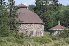 | Annala Round Barn | building | 1979 | 79000085 |
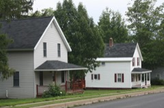 | Montreal Company Location Historic District | district | 1980 | 80000141 |
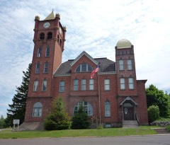 | Old Iron County Courthouse | building | 1977 | 77000031 |
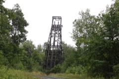 | Plummer Mine Headframe | structure | 1997 | 97001141 |
| Springstead | building | 1997 | 97000326 |
Every wildfire the federal occurrence database records inside this county: 298 of them, burning about 597 acres. 15 started naturally and 34 were recorded as arson. Each settlement page carries the fires within five miles of it.
| Reported cause | Fires |
|---|---|
| Missing data/not specified/undetermined | 69 |
| Debris and open burning | 61 |
| Equipment and vehicle use | 47 |
| Arson/incendiarism | 34 |
| Power generation/transmission/distribution | 25 |
| Recreation and ceremony | 19 |
| Natural | 15 |
| Misuse of fire by a minor | 10 |
| Other causes | 9 |
| Smoking | 5 |
| Fireworks | 3 |
| Railroad operations and maintenance | 1 |
The five largest, by the area the report gives. None of them was recorded as arson.
| Date | Cause | Size | Reported by | Name on the report |
|---|---|---|---|---|
| 10 May 2007 | Missing data/not specified/undetermined | 120 acres | Wisconsin Department of Natural Resources | not named |
| 9 June 2000 | Natural | 79 acres | Wisconsin Department of Natural Resources | not named |
| 29 April 2007 | Missing data/not specified/undetermined | 67 acres | Wisconsin Department of Natural Resources | not named |
| 20 May 2009 | Power generation/transmission/distribution | 39 acres | Wisconsin Department of Natural Resources | SOUTH END RD |
| 17 October 1995 | Missing data/not specified/undetermined | 35 acres | Wisconsin Department of Natural Resources | not named |
| 7 June 2000 | Natural | 29 acres | Chequamegon-Nicolet National Forest | BEAVER CREEK |
| 19 May 2012 | Natural | 21 acres | Great Lakes Agency | BEAR RIVER |
| 10 August 2001 | Debris and open burning | 20 acres | Wisconsin Department of Natural Resources | not named |
Every settlement page carries the fires within five miles of it - see the settlement index below.
The NOAA Storm Events Database holds 114 reports for this county, causing 1 death, 6 injuries and about $1,465,530 in recorded property damage. Each settlement page carries the reports that name it.
| Kind of event | Reports |
|---|---|
| Thunderstorm Wind | 59 |
| Hail | 40 |
| Tornado | 6 |
| Flash Flood | 4 |
| Lightning | 3 |
| Flood | 2 |
The most serious of them, by death, then injury, then recorded damage. The accounts are quoted exactly as the forecast office filed them.
| When | Event | Place named | Harm | What the report says |
|---|---|---|---|---|
| July 2016 | Flash Flood | Cedar | 1 killed, $1,000 | Flash flooding along the Oronto and Parker Creeks damaged the infrastructure of Saxon Harbor and parts of the Saxon Harbor Campground. One man died from the flooding. |
| July 2010 | Tornado (EF1) | Springstead | 3 hurt, $160,000 | This tornado likely began on the southern tip of Big Island. Aerial photographs taken by the Wisconsin Department of Natural Resources showed evidence of tornado damage on smaller islands over the western part of the flowage between the Turtle Dam and Springstead Landing. These islands had large sections of trees completely destroyed - either snapped or uprooted, and the aerial photographs revealed trees laying across one another in a cross-hatched pattern, in a few cases at 90 degree incidence angles. ||Substantial tree damage began occurring near Springstead Landing and east into a small neighborhood near the intersection of Flowage Rd. and Franks Ln. A stand of large trees between Flowage Landing Rd. and Simmons Rd. was completely demolished with similar evidence of tornadic winds. All of the trees were snapped or uprooted. ||Impacts to cabins in the area started on the western edge of Simmons Rd. and then continued into the neighborhood near the northern tip of Flowage Rd. Some structures in this area were damaged by falling trees. The tree damage in this neighborhood was still rather significant, with large trees up to 2 feet in diameter uprooted or snapped. The tornado then continued east where uprooted and snapped trees were noted along the edge of the shoreline near campsites D-31, C-2, and D-35 before damage became much more sporadic near the canoe portage. It was at this point where the damage path narrowed and the tornado likely ended. Three campers were injured while camping at remote campsites on the Turtle-Flambeau Flowage. |
| July 2000 | Lightning | Hurley | 2 hurt | A couple were struck by lightning while camping on an island in the Turtle-Flambeau Flowage, causing injuries severe enough for hospitalization. |
| August 2000 | Thunderstorm Wind | Springstead | 1 hurt | Several trees were knocked over by strong thunderstorm winds. A man was injured when an 18 inch diameter tree fell on him as he was in his camper on the Turtle Flambeau Flowage. Wind speed is estimated. |
| August 2013 | Lightning | Mercer | $1,000,000 | A house was hit by lightning. |
| July 1970 | Tornado | not stated | $250,000 | no account filed |
| May 2022 | Thunderstorm Wind | Sandrock | $15,000 | Part of a roof was ripped off a house along with part of a wall attached to a screen porch blown down. Approximately 10 trees as large as a foot and a half to two feet in diameter were down along with a pine tree that was snapped. |
| July 2011 | Lightning | Mercer | $10,000 | Lightning hit a shed and the shed caught on fire. The shed was located on Fisher Lake road in Mercer WI. |
| July 2010 | Thunderstorm Wind | Mercer | $10,000 | Numerous trees and power lines were blown down along Murray Landing Road. |
| August 2010 | Thunderstorm Wind | Sandrock | $5,000 | Numerous trees and power lines were blown down in the Oma community. |
| August 2010 | Thunderstorm Wind | Mercer | $5,000 | Numerous trees and power lines were blown down. |
| July 2010 | Thunderstorm Wind | Mercer | $5,000 | Numerous trees were blown down. |
| July 1958 | Tornado (F2) | not stated | $2,500 | no account filed |
| August 2010 | Thunderstorm Wind | Mercer | $2,000 | Trees were blown down with power outages reported around town. |
| June 1983 | Tornado (F0) | not stated | $30 | no account filed |
| June 2025 | Thunderstorm Wind | Gurney | - | Significant wind damage was reported with many uprooted trees that were twisted and broken. |
| July 2023 | Thunderstorm Wind | Springstead | - | A tree was downed onto a road in Springstead. |
| July 2023 | Thunderstorm Wind | Mercer | - | A tree was downed onto a road in Mercer. |
| May 2022 | Thunderstorm Wind | Springstead | - | Photos were received showing numerous large trees down across roads that were cracked near the base or uprooted. |
| June 2022 | Thunderstorm Wind | Gile | - | A tree collapsed onto powerlines. |
| July 2021 | Thunderstorm Wind | Mercer | - | Multiple trees were reported down in the Town of Mercer and the local fire department was dispatched to several locations around town following the storm. |
| July 2020 | Thunderstorm Wind | Mercer | - | A large tree 14 inches in diameter fell and took out power lines. The tree was removed by the local fire department. |
| July 2020 | Thunderstorm Wind | Manitowish | - | A 9 inch diameter healthy tree was downed by the storm. |
| September 2020 | Tornado (EF0) | Rouse | - | A brief, weak tornado caused tree damage across mainly county-owned forested land southwest of Upson. |
| June 2018 | Thunderstorm Wind | Gile | - | There was tree damage from the winds along Highway C in and near Carey. |
| June 2018 | Thunderstorm Wind | Mercer | - | The thunderstorm winds broke power poles. |
| June 2018 | Flash Flood | Germania | - | Two feet of water covered the intersection of US Highway 2 and County Highway D. |
| June 2018 | Flash Flood | Gile | - | Water was flowing over Knight Road were it crosses the Gile Flowage. |
| August 2018 | Thunderstorm Wind | Montreal | - | Several trees were downed along State Highway 77 in Montreal. |
| August 2018 | Thunderstorm Wind | Hurley | - | A few trees were knocked down into business parking lots along 10th Avenue North. |
| May 2017 | Hail | Powell | - | A member of the public called in reporting pea to dime size hail. |
| May 2016 | Thunderstorm Wind | Mercer | - | A thunderstorm blew down trees near the intersection of Highway 51 and Moose Lake Road. |
| August 2016 | Hail | Hurley | - | The hailstones ranged from the size of peas to just less than the size of quarters. The hail fell for approximately 10 minutes. |
| July 2016 | Tornado (EF1) | Van Buskirk | - | There was enough evidence to indicate a quasi-linear convective tornado developed over rural east-central Iron County, south of Van Buskirk, during the late evening. It heavily damaged a barn structure and a car, and it also damaged some homes and mangled some trees. |
| July 2016 | Thunderstorm Wind | Iron Belt | - | There were many trees and power lines down in Iron Belt. |
| July 2016 | Hail | Mercer | - | The hail fell for about 5 minutes. The largest stones were a little less than one inch in diameter. |
| April 2013 | Flood | Birch | - | Numerous roads were flooded. |
| July 2013 | Hail | Montreal | - | A thunderstorm dropped pea to quarter size hail. Wind gusts knocked down a 6 inch diameter tree. |
| July 2013 | Thunderstorm Wind | Montreal | - | Thunderstorm wind gusts blew down numerous trees in Montreal and in the area Hundreds of homes and businesses lost power due to downed power lines. |
| May 2013 | Flood | Cedar | - | Flooding continued from late April. Numerous roads were flooded. |
| August 2013 | Thunderstorm Wind | Tyler Forks | - | There was a tree down on Wisconsin Highway 77 just east of the county border. The time was based on radar. |
| July 2012 | Thunderstorm Wind | Hurley | - | Sporadic wind damage was reported, especially along the Rt 2 corridor. |
| July 2012 | Thunderstorm Wind | Mercer | - | Numerous trees and power lines were brought down along County Road FF. |
| July 2011 | Thunderstorm Wind | Springstead | - | Trees were blown down near Fishermans' Landing. Trees were also down across many other parts of Iron County. |
| July 2011 | Thunderstorm Wind | Springstead | - | Campers were stranded as their canoes and boats were blown away from their campsites. |
| May 2011 | Thunderstorm Wind | Mercer | - | Several trees were blown down. |
| May 2010 | Thunderstorm Wind | Mercer | - | Some trees were reported blown down. |
| May 2008 | Hail | Springstead | - | The hail fell at Cedar Cove Cabins. |
| June 2007 | Thunderstorm Wind | Mercer | - | Large trees were blown down. |
| July 2007 | Thunderstorm Wind | Mercer | - | Two trees downed on County Highway H. |
| July 2007 | Thunderstorm Wind | Mercer | - | Three large trees downed on Cedar Lake Circle. |
| July 2006 | Thunderstorm Wind | Upson | - | Several twelve to eightenn inch diameter trees were blown down. |
| June 2005 | Thunderstorm Wind | Mercer | - | Trees and large brances were blown down. |
| June 2005 | Thunderstorm Wind | Mercer | - | Trees and power lines were blown down. |
| June 2005 | Thunderstorm Wind | Mercer | - | Power was lost when trees fell on power lines. |
| July 2005 | Flash Flood | Mercer | - | Ditches filled with water and spread onto area roads. |
| August 2005 | Thunderstorm Wind | Mercer | - | Numerous trees and power lines were blown down. Most damage was along and either side of County Highway FF near Pike Lake and Little Pike Lake. Power was out at Mercer. |
| June 2002 | Thunderstorm Wind | Hurley | - | Numerous trees were blown down. |
| June 2002 | Thunderstorm Wind | Gile | - | Falling trees downed power lines. |
| July 2002 | Thunderstorm Wind | Mercer | - | Numerous trees and power lines were blown down. |
The Survey's mineral resources record lists 96 workings inside this county. 4 still produce and 92 are closed or unrecorded. Each settlement page carries the workings within five miles of it.
| Commodity | Workings |
|---|---|
| Sand and Gravel, Construction | 65 |
| Iron | 25 |
| Stone, Crushed/Broken | 2 |
| Water, Free | 2 |
| Kyanite | 1 |
| Iron, Nickel | 1 |
| Clay, Sand and Gravel, Construction | 1 |
| Manganese, Iron | 1 |
The least common of them first, because a county's hundredth gravel pit says nothing its first ten did not.
| Where | Site | Commodity | Status | Recorded |
|---|---|---|---|---|
| Barr Creek Pit | Clay, Sand and Gravel, Construction | Occurrence | ||
| Manitowish Range Kyn Occurrence | Kyanite | Occurrence | Metamorphic | |
| Montreal Mine | Manganese, Iron | Past Producer | 1886 | |
| Pence Mine | Iron, Nickel | Past Producer | 1888, 1912 | |
| Gogebic Deposit | Iron, Water, Free | Prospect | 1848 | |
| Hurley Quarry #1 | Stone, Crushed/Broken | Occurrence | ||
| Hurley Quarry #2 | Stone, Crushed/Broken | Occurrence | ||
| Pine Lake Taconite Deposit | Iron, Water, Free | Prospect | Surface | |
| Atlantic Mine | Iron | Past Producer | 1848, 1887, 1913 | |
| Atlantic Mine | Iron | Past Producer | 1887 | |
| Cary Mine | Iron | Past Producer | 1848, 1886, 1950 | |
| Cary Mine | Iron | Past Producer | 1886 | |
| Germania Mine | Iron | Past Producer | 1848, 1885, 1912 | |
| Germania Mine | Iron | Past Producer | 1885 | |
| Gogebic Deposit | Iron | Occurrence | 1848 | |
| Hennepin-Snyder | Iron | Past Producer | 1888 | |
| Hennepin-Snyder Mine | Iron | Past Producer | 1848, 1888, 1906 | |
| Iron Belt Mine | Iron | Past Producer | 1848, 1888, 1912 | |
| Iron Belt Mine | Iron | Past Producer | 1888 | |
| Mercer District | Iron | Unknown | Magnetite | |
| Montreal Mine | Iron | Producer | 1848, 1886 | |
| Moose Lake | Iron | Unknown | Magnetite | |
| Pence Mine | Iron | Past Producer | 1888 | |
| Pine Lake Taconite Deposit | Iron | Prospect | Hematite, Magnetite | |
| Plumer Mine | Iron | Past Producer | 1848, 1912, 1932 | |
| Plumer Mine | Iron | Past Producer | 1912 | |
| Shores Mine | Iron | Past Producer | 1848, 1896, 1899 | |
| Shores Mine | Iron | Past Producer | 1896 | |
| Tyler's Fork Prospect | Iron | Past Producer | 1848, 1890 | |
| Tylers Fork Mine | Iron | Past Producer | 1902 | |
| Upson Prospect | Iron | Past Producer | 1848, 1902, 1903 | |
| Apple Creek Pit | Sand and Gravel, Construction | Past Producer | ||
| Beaver Creek Pit #1 | Sand and Gravel, Construction | Occurrence | ||
| Beaver Creek Pit #2 | Sand and Gravel, Construction | Occurrence | ||
| Boot Lake Pit | Sand and Gravel, Construction | Occurrence | ||
| Casey Sag Rd Pit | Sand and Gravel, Construction | Past Producer | ||
| Cecil Lovell Pit #1 | Sand and Gravel, Construction | Occurrence | ||
| Cecil Lovell Pit #2 | Sand and Gravel, Construction | Occurrence | ||
| Cedar Sand Pit | Sand and Gravel, Construction | Occurrence | ||
| Dump Rd Pit | Sand and Gravel, Construction | Occurrence | ||
| Erickson Cr Pit | Sand and Gravel, Construction | Past Producer | ||
| Ferry Lake Pit | Sand and Gravel, Construction | Occurrence | ||
| Flood Creek Pit | Sand and Gravel, Construction | Occurrence | ||
| Fred Losby Pit | Sand and Gravel, Construction | Occurrence | ||
| Hurley Sand Pit | Sand and Gravel, Construction | Past Producer | ||
| Iron County Operations | Sand and Gravel, Construction | Producer | ||
| John Malone Pit | Sand and Gravel, Construction | Occurrence | ||
| Kamke Pit #1 | Sand and Gravel, Construction | Occurrence | ||
| Kamke Pit #2 | Sand and Gravel, Construction | Occurrence | ||
| Katie Saari Pit | Sand and Gravel, Construction | Occurrence | ||
| Koehmstedt Rd Pit | Sand and Gravel, Construction | Occurrence | ||
| Lahti Rd Pit | Sand and Gravel, Construction | Occurrence | ||
| Lawrence Creek Pit #1 | Sand and Gravel, Construction | Occurrence | ||
| Lawrence Creek Pit #2 | Sand and Gravel, Construction | Occurrence | ||
| Layman's Creek Gravel Pit #1 | Sand and Gravel, Construction | Past Producer | ||
| Layman's Creek Gravel Pit #2 | Sand and Gravel, Construction | Past Producer | ||
| Lillian Sorvari Pit | Sand and Gravel, Construction | Occurrence | ||
| Little Muskie Lake Pit | Sand and Gravel, Construction | Past Producer | ||
| Lower Rd Pit #1 | Sand and Gravel, Construction | Occurrence | ||
| Lower Road Pit #2 | Sand and Gravel, Construction | Occurrence | ||
| Lower Springstead Lake Pit | Sand and Gravel, Construction | Occurrence | ||
| Lyon Rd Pit | Sand and Gravel, Construction | Occurrence | ||
| Manitowish River Pit #1 | Sand and Gravel, Construction | Past Producer | ||
| Manitowish River Pit #2 | Sand and Gravel, Construction | Occurrence | ||
| Mercer Pit #1 | Sand and Gravel, Construction | Occurrence | ||
| Mercer Pit #2 | Sand and Gravel, Construction | Past Producer | ||
| Mercer Pit #3 | Sand and Gravel, Construction | Occurrence | ||
| Mirror Lake Pit | Sand and Gravel, Construction | Occurrence | ||
| Montreal River Pit | Sand and Gravel, Construction | Occurrence | ||
| Montreal Sand Pit | Sand and Gravel, Construction | Occurrence | ||
| Mosinee Rd Pit | Sand and Gravel, Construction | Occurrence | ||
| Muskie Lake Pit | Sand and Gravel, Construction | Past Producer | ||
| O'Brian Lake Rd Pit #1 | Sand and Gravel, Construction | Past Producer | ||
| O'Brian Lake Rd Pit #2 | Sand and Gravel, Construction | Past Producer | ||
| Paul Witkin Pit | Sand and Gravel, Construction | Past Producer | ||
| Peterson Sand & Gravel Pit | Sand and Gravel, Construction | Unknown | ||
| Pine Lake Rd Pit | Sand and Gravel, Construction | Occurrence | ||
| Potato River Pit #1 | Sand and Gravel, Construction | Past Producer | ||
| Potato River Pit #2 | Sand and Gravel, Construction | Past Producer | ||
| Potato River Pit #3 | Sand and Gravel, Construction | Past Producer | ||
| Potato River Pit #4 | Sand and Gravel, Construction | Past Producer | ||
| Powell Pit #1 | Sand and Gravel, Construction | Past Producer | ||
| Powell Pit #2 | Sand and Gravel, Construction | Past Producer | ||
| Richards Pit | Sand and Gravel, Construction | Occurrence | ||
| Sandy Beach Lake Pit | Sand and Gravel, Construction | Past Producer | ||
| Sherman Lake Pit #1 | Sand and Gravel, Construction | Occurrence | ||
| Sherman Lake Pit #2 | Sand and Gravel, Construction | Past Producer | ||
| Springstead Pit | Sand and Gravel, Construction | Past Producer | ||
| Stone Lake Pit | Sand and Gravel, Construction | Occurrence | ||
| T-Bird Pit | Sand and Gravel, Construction | Producer | ||
| Tomak Pit | Sand and Gravel, Construction | Producer | ||
| Upper Rd Pit | Sand and Gravel, Construction | Occurrence | ||
| Upson Lake Rd Sand Pit | Sand and Gravel, Construction | Past Producer | ||
| Valley Rd Pit | Sand and Gravel, Construction | Occurrence | ||
| Vaughn Creek Pit | Sand and Gravel, Construction | Occurrence | ||
| William Vittone Pit | Sand and Gravel, Construction | Occurrence |
Named settlements recorded in the Geographic Names Information System, each with the topographic sheets covering it. Villages, hamlets and abandoned places alike. Each is shown with the nearest named watercourse or landform and the survey quadrangle it falls on.